2. How are glacial landforms developed?
1/37
There's no tags or description
Looks like no tags are added yet.
Name | Mastery | Learn | Test | Matching | Spaced | Call with Kai |
|---|
No analytics yet
Send a link to your students to track their progress
38 Terms
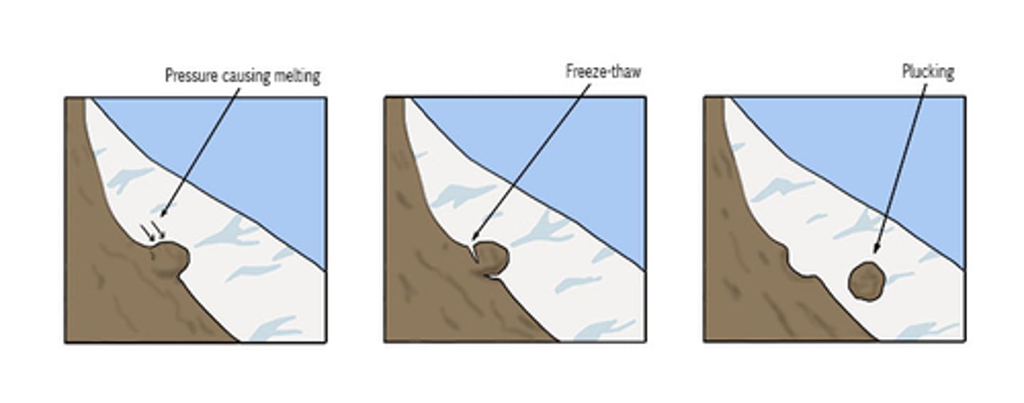
Plucking
- Meltwater freezes into joints or cracks in the rocks surface and becomes attached to the glacier
- As the glacier advances it pulls pieces of the rocks away
- Plucking is most effective on jointed or previously weathered rock surfaces
- It requires presence of meltwater, so can take place where ice reaches PMP

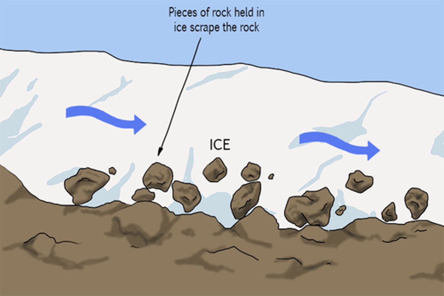
Abrasion
- Occurs where glacial ice is in contact with the valley bottom and sides
- Ice at the bottom of the glacier carries debris with it and this, in turn, scratches or abrades the bedrock surface
- Clear ice alone is not able to scratch the surface of the rock
- The glacial debris itself is also worn down in the process, forming a fine rock flour that is responsible for the milky white appearance of glacial meltwater streams

Nivation
A glacial process that is not easily classified as erosion or weathering. Complex combination of freeze-thaw action, soliflucation, transport by running water and possibly chemical weathering. Nivation is thought to be responsible for the initial enlargement of hillside hollows and the incipient development of corries
Material transported in glacial environment
Rockfall - Weathered debris falls under gravity from the exposed rock above the ice down onto the edge of the glacier
Avalanches - These often contain rock debris within the snow and ice that moves under gravity
Debris flows - In areas of high precipitation and occassional warmer periods, melting snow or ice can combine with scree, soil and mud
Aeolian deposits - Fine material carried and deposited by wind, often blowing across outwash deposits
Volcanic eruptions - A source of ash and dust
Plucking - Large rocks plucked from the side and base of valleys
Abrasion - Smaller material worn away from valley floors and sides
Supraglacial transportation
Debris carried on the surface of the glacier. This will most often come from weathering and rockfall
Englacial transportation
Debris within the ice - supraglacial material covered by further snowfall, fallen into crevasses or sunk in ice due to localised PMP
Subglacial transportation
Debris embedded in base of glacier which may have been derived from plucking and abrasion, or that has continued to move down through the ice as former englacial debris
Mass movement - Rock fall
On slopes of 40 degrees or more, especially if the surface is bare, rocks may become detached from the slope by physical weathering processes. These then fall to the foot of the slope under gravity. Transport processes may then remove this material, or it may accumulate as a relatively straight, low angled scree slope
Mass movement - Slides
These may be linear, with movement along a straight line slip plane, such as a fault or a bedding plane between layers of rock, or rotational, with movement taking place along a curved slip plane. Rotational slides are also known as slumps. In glaciated landscape systems, slides may occur due to steepening or undercutting of valley sides by erosion at the base of the slope, adding to the downslope forces. Slumps are common in weak rocks such as clay, which also become heavier when wet, adding to the downslope force
Corrie
Armchair-shaped hollow found on upland hills or mountainsides
How does a corrie form
1. Development starts with nivation of a small hollow on a hillside in which snow accumulates and collects year on year
2. Eventually, the hollow enlarges and the snow compresses to form glacial ice
3. At a critical depth, ice acquires rotational movement under its own weight, which further enlarges the hollow
4. The rotational movement creates plucking of the back wall, making it increasingly steep
5. The debris derived from plucking and weathering above the hollow falls into the bergschrund crevasse which abuts the back wall (freeze-thaw)
6. The rock debris helps to abrade, and therefore deepen the hollow
7. Once the hollow has deepened, the thinner ice at the front is unable to erode as rapidly, and so a higher lip is left
8. The lip may also consist of moraine deposited by the ice as it moves out of the corrie
9. In a post-glacial landscape, a corrie may become filled with water forming a small circular lake (tarn)
Arete
A narrow, steep-sided ridge found between two corries E.g. striding edge, lake district
Plucking makes an arete increasingly steep
Pyramidal peak
When a hill has been eroded to form three or four corries, leaving a sharp tip/horn or a pyramidal peak
Glacial trough
Also can be called U-shaped valleys
Typically have steep valley sides, some material has been dumped down to make the sides a bit gentler over the years (scree slopes)
When compressing flow occurs, the valley is over-deepened to form rock basins and rock steps
Misfit stream
A small stream in the bottom of a glacial trough, it looks too small to have made the valley
Truncated spurs
Interlocking spurs are truncated as the glacier cuts/bulldozes straight through the landscape
Ribbon lakes
Long and thin lakes created by an over-deepened valley floor, that collects meltwater and rainwater after the glacier has melted.
rouche moutonnee
A rock hill shaped by the passage of ice to give a smooth up side and a rough, plucked surface on the downside
How is a rouche moutonnee formed
1. Forms as a glacier moves over pertruding bedrock in the valley, it erodes as it does so
2. As the glacier moves over the rock its weight applies a lot of pressure on the base
3. PMP is hit and this causes the glacier's base to melt, creating meltwater. Localised PMP allows there to be a smooth and streamlined side of the rock
4. The meltwater allows the glacier to move over the rock. It stays as meltwater due to pressure
5. The uphill part of the rock is getting smoothed
6. After the glacier has moved uphill, the pressure decreases and less energy is needed to travel
7. This causes the meltwater to freeze again as there is less pressure
8. The frozen water then freezes to the back of the rock and plucks it as the ice moves forward, leaving cracks in the back
Striations
On the valley floor, striations can be found carved into the resistant bedrock. These are gauges or scratches in the rock where moraine has been dragged over the bedrock
Formed by abrasion
They run parallel in direction to ice movement
Till
unsorted sediment in the glacier valley
Lodgement till
Till deposited from a moving glacier
Ablation till
Till deposited from a melting glacier
Ground moraine
Moraine spread all over the ground as a glacier retreats up valley in warmer times
Lateral moraine
Ridges of moraine that come down the valley sides and run parallel to valley sides
Medial moraine
Ridge of rocks running down the middle of a valley formed by two lateral moraines from two glaciers coming together
Recessional moraine
These often run parallel to terminal moraines and these ridges of material mark the retreat of each glacier. Each recessional moraine marks a point where the ice has been static long enough in the glaciers retreat for material to build up
Push moraines
Mounds of material found where a drop in temperature or increase in precipitation allows glacial re-advance, and the glacier pushed previously deposited moraines forward into a new landform. This can change the orientation of the stones found in the original landform
Why is till deposited as moraine
A period of ablation
Glacier is carrying too much weight and doesn't have enough energy
Till plain
Formed when large masses of unstratified drift, deposited at the end of an advance, smother the surface. It is an unsorted mixture of rocks, clays and sands.
Largely transported as supraglacial debris, later deposited to form moraine, either during periods of active ice movement or when the glacier was in retreat
A till plain is a large expanse of gently rolling hills of till, formed when an ice sheet melts where it is
Erratic
Large rocks or boulders that have been picked up by a glacier or an ice sheet, carried along and dropped in an area of completely different geology. Could be as large as a boulder
Norber erratics in the Yorkshire Dales -- Silurian Sandstone boulders sit on top of limestone which is 100 million years younger
Meltwater streams could move the erratic slightly further after it has been deposited by the glacier
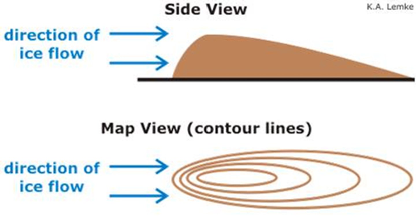
Drumlin
Half-egg shaped hills of till, up to 1500m long and 100m high. The upstream (stoss) end is wide and tall, and the downstream (lee) end is narrow and long.
Drumlins often form in groups (swarm)
Streamlined shape seems to suggest that they were formed during the glacial period
Theories are that the till got stuck around a rock or a little hill sticking out into the glacier. The ice readvances over it. Subglacial sediment deformation can lead to the formation of a drumlin --> the moulding and sculpting of till beneath the glacier by force of the moving glacier
Can form both during deposition and erosion
Meltwater streams can also create the drumlins
