Tropical Storms
1/24
There's no tags or description
Looks like no tags are added yet.
Name | Mastery | Learn | Test | Matching | Spaced | Call with Kai |
|---|
No study sessions yet.
25 Terms
What is a tropical storm? Characteristics?
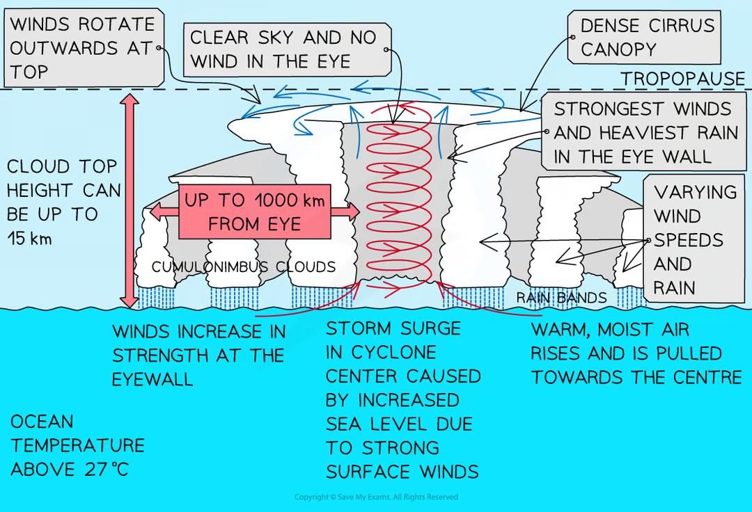
A localised, intense, low pressure system characterized by heavy rainfall, high windspeeds of over 119kmh and high waves & storm surges
Where are the strongest most destructive winds found?
Within the eyewall.
Explain the global distribution of tropical storms:
Tropical storms from between 5° to 30° N & S of the equator because the sea temperature must be 26.5°C or higher.
What are tropical storms known as in the South China Sea & West pacific ocean?
Typhoons.

What are tropical storms known as in the Gulf of Mexico, Caribbean Sea and the west coast of Mexico?
Hurricanes.
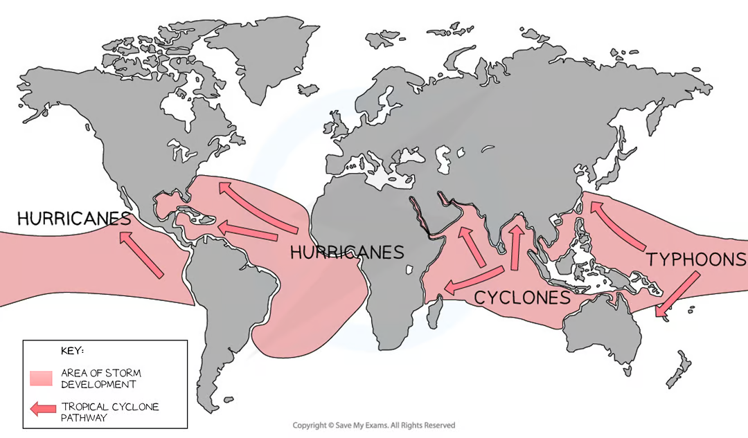
What are tropical storms known as in the Bay of Bengal & Indian ocean?
Cyclones.

When do tropical storms develop?
When the sea temperature is 26.5°C or higher and the wind shear between higher and lower parts of the atmosphere is low.
When do tropical storms tend to occur in the Northern hemisphere?
From June to November.
When do tropical storms tend to occur in the Southern hemisphere?
From November to April.
How long do tropical storms tend to last?
7-14 days.
Describe the formation of a tropical storm:
Warm, moist air rapidly rises, the rising air creates areas of low pressure, which increases surface winds
Air from high-pressure areas rushes in to replace the rising air
This air then rises, forming a continuous flow of air
As the air rises, it cools & condenses - this releases large amount of heat energy which helps to power the tropical storm
Air at the top of the storm goes outwards away from the center of the storm
The Coriolis effect causes the rising air to spiral around the center
Some of the air sinks in the middle of the storm, creating a cloudless, calm eye
The tropical storm moves westward from its source due to the easterly winds near the equator
If it makes landfall/moves over cool water →no longer has a supply of warm moist water so loses speed + energy and rainfall & winds decrease
When do tropical storms dissipate (lose strength)?
When moving over land or cooler water because it loses its supply of warm moist water so loses speed & energy and this also causes rainfall & winds to decrease.
When do tropical storms intensify?
When moving on areas of warmer water which gives them more energy.
Why do tropical storms move west?
Due to easterly winds near the equator.
What is the calm central area of a tropical storm called?
The eye.
What is the maximum distance the eye of storm can stretch?
up to 50km.
Describe the conditions in the eye:
Low pressure, light winds, no clouds, no rain & high temperature.
Describe the conditions on the outer edges of the storm:
Lighter wind speeds, smaller + more scattered clouds, rain is less intense, temperatures begin to increase.
What are tropical storms rated on?
The Saffir Simpson scale, based on windspeeds.
When are tropical storms considered major on the scale?
When they reach category 3 and have wind-speeds between 178-208km/h.
How fast can a category 5 storm deliver windspeeds?
More than 252km/h.
Why might tropical storms be becoming more frequent & intense?
Due to global warming, as sea temperatures rise more of the worlds ocean could be above 26.5°C, this means more places may experience tropical storms. Plus oceans will stay at 26.5°C or higher for longer during the year.
In addition, warmer ocean temperatures provide more energy for storms to intensify. As the earth’s atmosphere heats up, it can hold more moisture - heavier rainfall during storms.
Rising sea levels can also increase the impact of storm surges - making them more destructive.
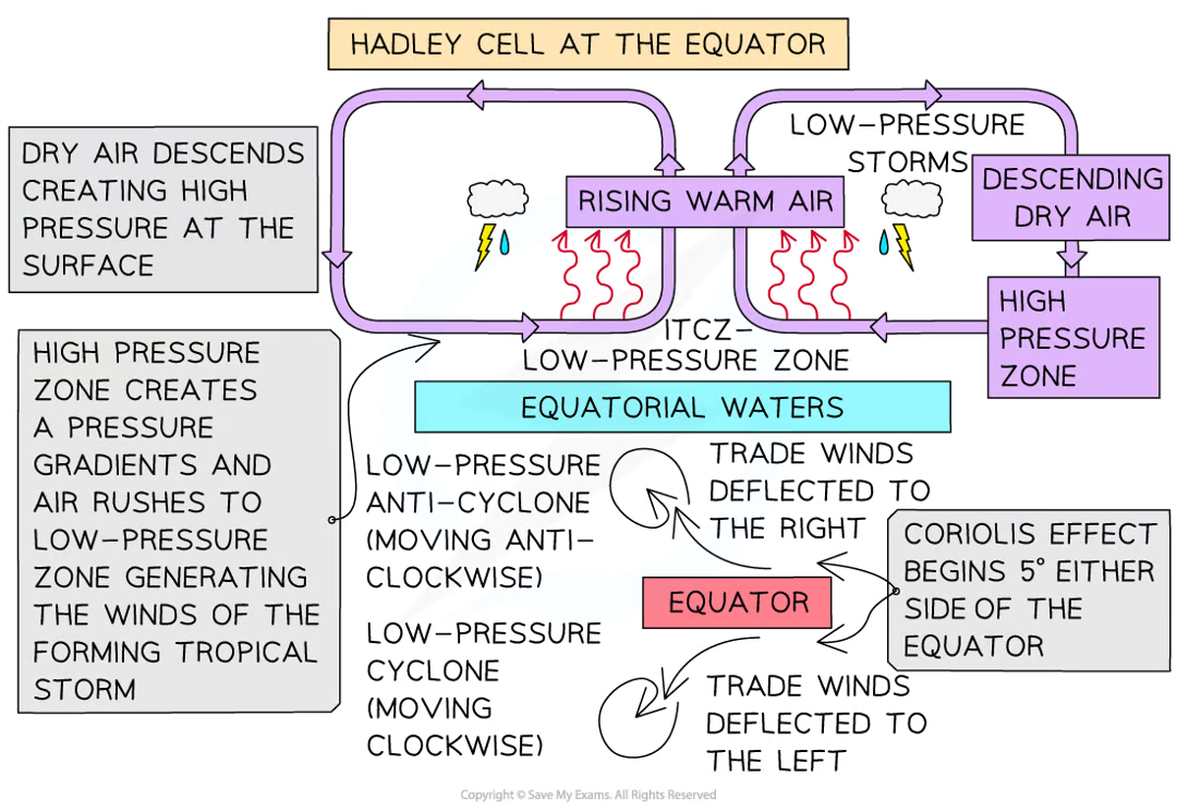
What 3 aspects of atmospheric circulation are most closely related to tropical storms?
Hadley Cell
Coriolis effect
Equatorial trade winds
Describe how the 2 Hadley cells at the equator play a part in forming tropical storms:
The equatorial regions receive intense solar energy - raising ocean temps
This warm, moist air rises, leading to an intense low-pressure zone between the 2 Hadley cells called the Intertropical Convergence zone (ITCZ)
This generates thunderstorms, strong winds & intense rainfall at the surface
Dry air descends creating a high-pressure zone at the surface
This generates pressure gradients & air rushes to the low pressure zone generating the winds of the forming tropical storm
How are tropical cyclones predicted?
Satellites are used to spot a tropical cyclone forming and track its progress
Forecasters can predict its track and estimate likely storm surge heights and rainfall levels