Archaeological Survey Methods - Study Outline Attached
1/180
There's no tags or description
Looks like no tags are added yet.
Name | Mastery | Learn | Test | Matching | Spaced |
|---|
No study sessions yet.
181 Terms
What is an archaeological site?
Any place where material evidence exists about the human past, often referring to a concentration of such evidence.
What is the primary objective of CRM archaeology?
To locate archaeological sites rather than excavate them, ensuring the protection of cultural resources.
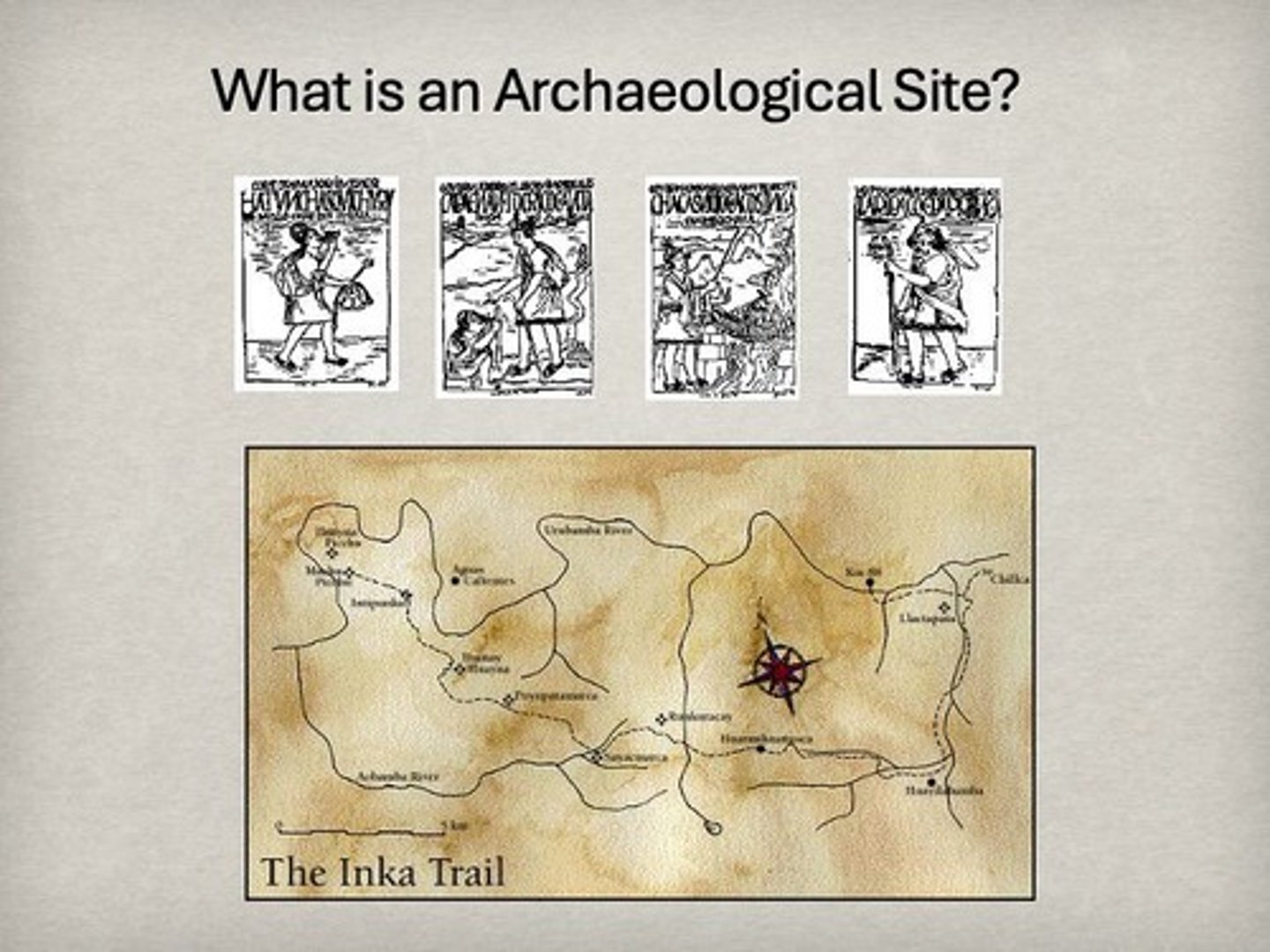
Who was John Hyslop and what did he study?
An archaeologist who investigated the Inka road systems in Peru, mapping their location and understanding their function.
What are some examples of archaeological site types?
Lithic scatters, rock art sites, road systems, irrigation systems, and offering places.
What are Songlines in Indigenous Australian culture?
Spiritual and physical pathways used for navigation, cultural knowledge transmission, and connecting to ancestral lands.
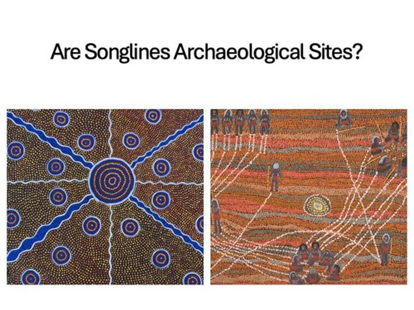
How do Songlines function as navigational tools?
They serve as 'mental maps' that provide information on landmarks, water sources, and safe travel through songs and rituals.
What role do oral traditions play in Songlines?
They are passed down through generations, encoding cultural knowledge and navigation instructions within songs and stories.
What is the significance of Songlines for Indigenous identity?
They carry social laws, customs, and values that shape community life and maintain cultural identity.
What is an example of an industrial archaeological site?
The Turner Valley Gas Plant, located in Diamond Valley.
What is the Stampede Elm and its significance?
A heritage tree over 100 years old, representing cultural history before being removed for urban development.
Can landscapes be considered archaeological sites?
Yes, landscapes can hold cultural significance even without material remains, as seen in traditional place names indicating historical events.
What is the fallacy of the 'typical' archaeological site?
The misconception that archaeological sites must fit a conventional definition, ignoring diverse site types and cultural significance.
What is the role of statistical sampling in archaeological surveys?
It helps archaeologists systematically locate and assess sites across a region.
What is non-site archaeology?
The study of archaeological evidence that does not conform to traditional site definitions, focusing on broader regional patterns.
What is the importance of recognizing diverse site types in archaeology?
It allows archaeologists to understand the full complexity of human interaction with the landscape.
What does the term 'cultural landscape' refer to?
A broader concept that includes archaeological sites as part of the cultural significance of a landscape.
How do Songlines facilitate cultural exchange?
Their melodic and rhythmic nature can transcend linguistic barriers, promoting communication among different Indigenous groups.
What is the significance of the oral encyclopedia aspect of Songlines?
They encode vital information about the environment, including safe food and water sources and territorial boundaries.
What is the relationship between Songlines and ancestral lands?
Songlines create a deep connection between people and their ancestral lands, linking them to cultural narratives and histories.
What is the role of kinetic rituals in Songlines?
They activate the knowledge embedded in the songs through the act of walking and singing along the landscape.
What are some examples of cultural resources that need protection in CRM archaeology?
Natural and cultural resources affected by development, mining, and logging activities.
What is the significance of the Northwest Trail in archaeological studies?
It serves as an example of a trail used historically, representing human interaction with the landscape.
What is the purpose of archaeological surveying?
To locate and document archaeological sites for research and heritage management.
What is the significance of a regional approach in archaeology?
It allows archaeologists to investigate the past by considering the broader cultural landscape and variations in features across regions.
What are the stone outlines of kayaks (qajaqs) at Arvia'juaq used for?
They were used to train young people in kayak hunting techniques.
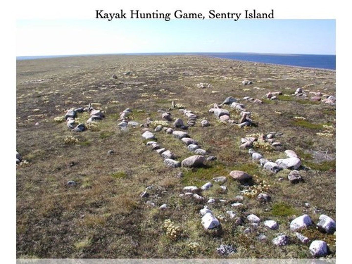
Name three archaeological features found at Arvia'juaq.
Caribou Crossing Game, Healing Stones, Tent Rings.
What does the archaeological site of Arvia'juaq represent?
It constitutes a microcosm of the larger cultural landscape of the Kivalliq District of Nunavut, reflecting Inuit activities over millennia.
What time period does the Fremont culture cover?
AD 500-1400.
What are some characteristics of the Fremont culture?
Horticulture, pit house villages, above-ground pueblos, distinctive pottery, and hunting of bighorn sheep and deer.
What is the Promontory culture and when did it exist?
Defined by Julian Steward as dating to about AD 1000, characterized by hunting/gathering and absence of architecture.
What led to the misinterpretation of Promontory culture?
Closer examination revealed that Promontory sites were seasonal hunting camps used by Fremont groups, not a distinct culture.
What is the importance of defining different types of archaeological sites?
It helps avoid generalizations about pre-contact culture change and improves understanding of cultural dynamics.
Who is Richard 'Scotty' MacNeish and what is his contribution to archaeology?
A famous archaeologist known for using deductive reasoning to locate archaeological sites based on environmental characteristics.
What factors did MacNeish consider when predicting the location of archaeological sites?
Presence of water, access to game lookouts, and characteristics of the landscape such as slope and cave features.
How did A.V. Kidder contribute to archaeological site location?
He used previous experiences to predict site locations based on where other sites were found, particularly in the American Southwest.
What is the role of Geographic Information Systems (GIS) in archaeology?
GIS helps archaeologists predict site locations based on terrain attributes like slope, aspect, and proximity to water.
How is AI transforming archaeological site prediction?
AI uses extensive archaeological databases to automate and enhance the accuracy of site location predictions.
What is the fallacy of the typical site in archaeology?
The assumption that a single site within a culture area is representative of all other sites, which is often inaccurate.
What defines a subsistence-settlement system in archaeology?
It describes how people make different seasonal and functional uses of the land, leading to a variety of site types.
What is the significance of the Kivalliq District in Nunavut for archaeology?
It contains important archaeological sites that reflect the long history and cultural practices of the Inuit people.
What types of archaeological features are associated with the Fremont culture?
Pit houses, above-ground pueblos, distinctive pottery, and evidence of horticulture.
What is an example of a seasonal hunting camp in archaeology?
Promontory sites were initially thought to be a distinct culture but were actually seasonal hunting camps used by Fremont groups.
What is the significance of the healing stones found at Arvia'juaq?
They represent cultural practices and beliefs of the Inuit people related to health and spirituality.
What challenges do archaeologists face when interpreting site contents?
Determining whether features reflect a single group's seasonal movements or multiple cultural groups occupying the same area.
What does the term 'artifact of archaeological mis-interpretation' refer to?
It describes a scenario where archaeological materials are incorrectly classified, such as the Promontory culture being misidentified.
What is the role of environmental criteria in locating archaeological sites?
Environmental factors like wildlife crossings and terrain features help archaeologists predict where sites may be found.
What is the significance of the Caribou Crossing Game at Arvia'juaq?
It reflects the hunting practices and training methods of the Inuit culture in the region.
Why is it important for archaeologists to study multiple site types?
To gain an accurate view of the economic, social, and ideological aspects of a cultural group.
What anthropologist defined the subsistence-settlement system for the Great Basin Shoshone and Paiute?
Julian Steward
What types of sites composed the subsistence-settlement system of the Shoshone and Paiute?
Winter villages, isolated hunting stands, gathering camps, antelope drive stations, and festival areas.
What would happen if an archaeologist only excavated winter camps of the Shoshone?
They would interpret Shoshone culture as consisting of extended families living in semi-sedentary villages.
What is the significance of the Carson Desert Survey?
It aimed to understand how wetland areas were used within the subsistence-settlement system of hunter-gatherers.
What were the two hypotheses proposed by Robert Kelley regarding wetland use?
1. Groups intensively used wetlands, living in large semi-sedentary villages. 2. Hunter-gatherers used wetlands briefly as part of a seasonal round.
What expectation would indicate that hunter-gatherers were intensifying their use of wetland areas?
Finding larger sites indicating more sedentary behavior.
What is surface archaeology?
The study of archaeological materials found on the surface of the ground, often in areas not disturbed by ploughing.
What is the first step in defining a subsistence-settlement system?
Acquiring a sample of archaeological sites that represent the entire range of site types in the area.
What is probabilistic sampling in archaeology?
A method where archaeologists divide areas into quadrats and randomly sample them to study site distribution.
What is a statistical population in the context of archaeological surveys?
A set of observations of interest, such as the lengths and widths of projectile points.
What is stratified random sampling?
A sampling method that adjusts sample sizes based on ecological zones to improve site discovery.
What is systematic sampling in archaeology?
A method where archaeologists systematically search selected quadrats using transects or test pits.
What is the purpose of using transect methods in systematic sampling?
To enable archaeologists to search quadrats in a linear direction.
What might be found in areas where archaeological materials are located on the surface?
Artifacts that have not been disturbed and occur where they were first dropped.
What is the significance of understanding the seasonal round of a cultural group?
It provides insight into their subsistence strategies and lifestyle.
What can happen if different types of archaeological sites are mistaken for different cultural groups?
It can lead to inaccurate interpretations of cultural diversity and practices.
What role does oral history play in understanding subsistence-settlement systems?
It provides additional context and insights into the cultural practices and environmental interactions.
What are the implications of finding smaller sites in wetland areas?
It suggests greater mobility and brief use of wetlands by hunter-gatherers.
How can historic and ecological information aid archaeological surveys?
They help develop hypotheses about where specific site types should be located.
What is the significance of identifying each type of site in a region?
It is essential for defining the complete seasonal round of a cultural group.
What is the relationship between site size and sedentary behavior in archaeological studies?
Larger sites typically indicate more sedentary behavior among hunter-gatherers.
What are the expected outcomes of testing hypotheses through archaeological surveys?
To validate or refute assumptions about cultural practices and site usage.
What is the role of statistical analysis in archaeological surveys?
It helps in interpreting data and making informed conclusions about site distributions.
Why is it impractical to search all quadrats in a large valley?
Due to time limitations and labor costs.
What two variables affect the accuracy of transect sampling strategies?
The distance between transects and the intervals along the transect at which the archaeologist stops to look for evidence.
What is the effect of closer transects on archaeological site discovery?
Closer transects increase discovery probability but also increase the time spent in the field.
What happens when transects are further apart?
Further apart transects decrease the probability of finding archaeological sites but also decrease the survey cost in terms of time.
What type of sampling strategy is used in transect sampling?
Systematic sample selection.
What methods can archaeologists use along transects?
They can either walk along the transect looking for remains or dig test pits at regular intervals.
What is the relationship between the distance between test pits and discovery probability?
Reducing the distance between test pits increases discovery probability but also increases cost in terms of time.
What is a circular sampling unit in archaeological surveys?
A sampling design where archaeologists survey around a point, such as a water source, at a defined radius.
How did Thomas conduct his survey in the Monitor Valley?
He used a circular sampling unit around springs to study the relationship of archaeological sites to water sources.
What is the significance of random sampling strategies in archaeology?
Random sampling can identify different site types before moving to a systematic strategy for more detailed data.
What challenges do archaeologists face in Gwaii Haanas?
Dense rainforests and rapid sea level changes complicate the search for archaeological sites.
What did Daryl Fedje's sea level history reveal about archaeological site locations?
It indicated that potential sites would be found between 15 and 20 meters above the modern high-tide mark, and 100 meters to 2 kilometers inland.
What is the significance of the time period between 9000 and 5000 bp in Gwaii Haanas?
During this period, sea levels were stable, which likely preserved cultural deposits in landforms.
What remote sensing technique did Fedje use for underwater surveys?
Swath bathymetric imaging.
What is swath bathymetric imaging used for?
It maps submerged landscapes using radar waves.
What did the underwater surveys in Gwaii Haanas aim to find?
Evidence of early human inhabitants and potential coastal migration routes.
What is a key outcome of Fedje's archaeological work in Gwaii Haanas?
The discovery of 17 new archaeological sites dating to the mid to early Holocene.
What does the term 'drowned landscapes' refer to?
Landforms that were once above water but are now submerged due to rising sea levels.
How did sea level changes affect the search for archaeological sites?
Fluctuating sea levels made it difficult to locate sites, as many are now underwater.
What hypothesis did archaeologists have about the migration of First Nations peoples?
They entered the New World before 12,500 bp, possibly through an ice-free corridor or along coastlines.
What challenges do rapid sea level changes present for archaeological surveys?
They complicate the identification and location of archaeological sites that may now be submerged.
What is the significance of the Carson Desert survey in relation to sampling strategies?
It began with random sampling to identify site types before transitioning to systematic sampling for detailed analysis.
What do quadrat and transect surveys provide information about?
They provide information on both where archaeological sites are and where they are not.
How does non-site archaeology assist developers and contractors?
It helps them re-route infrastructure like roads and pipelines by understanding archaeological site distributions.
What distinguishes non-site archaeology from site-oriented archaeology?
Non-site archaeology works at a regional scale, while site-oriented archaeology focuses on individual sites.
What type of sites are often found in Alberta during archaeological surveys?
Lithic scatters.
What factors can influence the discovery of archaeological sites?
Weather, vegetation cover, and contrast between artifacts and the ground surface.
What is the goal of full coverage surveys in archaeology?
To find all archaeological sites by surveying even unlikely areas.
What significant project surveyed the entire Valley of Oaxaca?
The Valley of Oaxaca Settlement Pattern Project.