AP Human Geography Unit 1 Vocabulary
 Call Kai
 Learn
Learn Practice Test
 Spaced Repetition
 Match
Match Flashcards
 Knowt Play
1/30

Earn XP
Description and Tags
Vocabulary flashcards covering Unit 1 concepts including geographic tools, scales of analysis, map projections, thematic maps, geospatial technology, spatial interaction, diffusion types, human-environment interaction, and regional types.
Name | Mastery | Learn | Test | Matching | Spaced | Call with Kai | Chat |
|---|
No analytics yet
Send a link to your students to track their progress
31 Terms
Large-scale maps
Maps that show a small geographic area with high detail, such as a city map with a ratio of 1:10,000.
Small-scale maps
Maps that show a large geographic area with less detail, such as a world map with a ratio of 1:1,000,000.
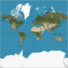
Mercator projection
A projection map that accurately shows direction and angles for navigation and compass points, but significantly distorts the size of landmasses at high latitudes.

Peters projection
A projection map that preserves true landmass size and area but distorts shapes.
Robinson projection
A visual compromise map that balances all map distortions including shape, size, distance, and direction.
Choropleth map
A thematic map that uses differences in shading or coloring across predefined administrative boundaries to show statistical data.
Dot Density map
A thematic map that uses dots to show frequency and distribution, where one dot represents a specific quantity like 10,000 harvested acres of wheat.
Proportional Circle map
A thematic map that uses sized circles to show data amounts.
Cartogram
A thematic map that distorts geographic size and space to reflect a specific variable, such as population where densely populated regions like Asia appear much larger.
Contour / Isoline map
A thematic map that uses contour lines to show elevations or physical changes across a surface.
Latitude
Parallels running east-west that measure north and south of the Equator (0∘).
Longitude
Meridians running north-south that measure east and west of the Prime Meridian (0∘).
GPS (Global Positioning Satellites)
A geospatial technology that provides absolute location data.
GIS (Geographic Information Systems)
A geospatial technology that analyzes multi-layered spatial data, essential for emergency dispatch routing and layering spatial features.
Remote Sensing
A geospatial technology that gathers imagery and data from a distance.
Time-Distance Decay
The geographic concept where interaction between places drops off as the distance and travel time between them increase.
Time-Space Compression
The geographic concept where modern technology and transport have shrunk global distance, dramatically increasing connectivity.
Globalization
The expansion of economic, cultural, and social processes on a global scale, such as Coca-Cola being sold in around 200 countries.
Interdependence
Mutual reliance between countries, often institutionalized through trade agreements such as NAFTA.
Relocation Diffusion
The spread of a feature or trend through the physical movement of people, such as immigrants bringing cultural holidays like Italian festivals to Boston.
Contagious Diffusion
Rapid, uniform spread of a feature or trend across a population, similar to a virus.
Hierarchical Diffusion
The spread of an idea or feature downward from centers of wealth, power, or authority.
Reverse Hierarchical Diffusion
The spread of an idea or feature upward from small or remote areas to major hubs.
Stimulus Diffusion
Diffusion in which the underlying idea spreads, but the specific form adapts to fit a new culture.
Environmental Determinism
An outdated theory stating that the physical environment completely dictates human culture and societal development.
Possibilism
The modern, accepted theory that the environment places limits or presents challenges, but human choices, culture, and technology ultimately shape development.
Nonrenewable resources
Resources such as fossil fuels that deplete much faster than they form.
Renewable resources
Resources such as solar and wind energy that replenish naturally.
Formal (Uniform) Region
A region defined by shared physical or cultural traits, such as the Sahara Desert or the Corn Belt.
Functional (Nodal) Region
A region organized around a focal point or node where activity fades outward, such as a city subway system or a pizza delivery zone.
Perceptual (Vernacular) Region
A region defined by people's cultural identities, shared concepts, and informal mental maps rather than strict scientific boundaries, such as John Shelton Reed's description of 'The South'.