AP human geo unit 1
1/60
Earn XP
Description and Tags
Name | Mastery | Learn | Test | Matching | Spaced | Call with Kai | Chat |
|---|
No analytics yet
Send a link to your students to track their progress
61 Terms
physical geography
study of natural processes and distribution of features in the enviorment such as landforms, plants, animals and climate
spatial perspective
refers to where something occurs
ecological persepctive
refers to the relationships between living things and their enviroments
location
position that a point or object occupies earth
absoulte location
exact location of an object
relative location
where a place is in relation to other places/ featrures
site
refers to a places absoulte location as well as physical characteristics
situation
places location in relation to other places/ surrounding featrures
place
location on earth that is distinguished by physical and human characteristics
space
area between two or more things on earth surface
distribution
arranged within a given space
density
number of things in a specific area op
pattern
how things are aranged
flow
how things move and change
enviornmental determinism
argues that human behavior is largley controlled by the physical envionemnt
possibilsm
argues that humnas have more agency, or ability to produce a result, then enviornemntal determinism would suggest
distance decay
describes the effect of distance on interactions
time-space compression
key geographic principle that is related to friction or distance
formal region
area that has one or more shared traits. can be physical or cultural or both; defined by data
scale
area of the world being studied
region
area on earth’s surface w/ certain characteristics that make it distinct from other areas
functional region
defined as an area organized by its function around a focal point, or center of interest
node
focus of region such as the downtown of a city
suburbs
residentials areas around a city
perceptual/ vernacular region
type of region that reflects people’s feeling and attuitudes about a place
world system theroy
describes spatial function relationships bertween countires in world economy
core
countires that are highly interconnected, good trnasportation and communication networks. good education, large political allies
periphery
countires that have less wealth, lower education and worse tech
semi periphery
both core and periphery processes. have a bit of both
sustainable development
development that meets the need of present with out compramising the ability of future generations to meet their own needs
quantitative
info measured by numbers
census
offical count of number of people in a difined area
qualititve
data interpreted of data sourecs such as field observations, media reports, travel narratives, policy doc, personal interviews, landscape analysis, and visuals
GIS
sophisticated mapping software. captures, stores, organizes, and displays geographic data that can be used to configure both simple and complex maps
topography
shape and features of land surfaces. (lakes and mountains)
remote sensing
collects data remotly, uses satellites or aircraft-based sensors to collect data
GPS
integrated network of atleast 31 satellites in the U.S. system that orbit Earth and trnasmit location data to handheld recivers
absoulte distance
distance that can be measured using a standerted unit of length
relative distance
measured in terms of other criteria such as time or money
absolute direction
north, south, east, west
relative direction
left, right, up, down
map scale
mathermatical relationship between the size of the map of part of the real world it shows
reference maps
generalized sources of geographic data and focus location
thematic maps
have a theme or specific purpose and focus on the relationship among geographic data
what does GIS stand for
Geographic information system
what does GPS stand for
Global Positioning System
human geography
is the study of events and processes that have shaped how humans understand, use, and alter earth
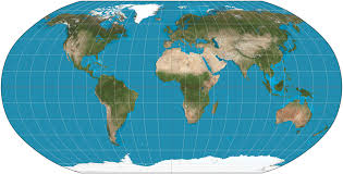
what map is this
robinson projection
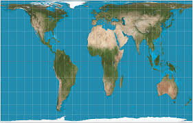
what map is this
mercator projection
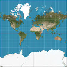
what map is this
gall-peters projection
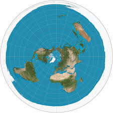
what map is this
azimuthal projection
socialogy
the science of study of the orgin and devolpment
ecology
study of ecosytems
cultural ecology
study of human - eviormental interactions
enviormental possibilsm
belief that the contraitns of physical enviornemntal can at times be overcome by culture
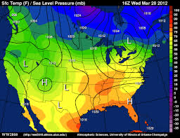
what map is this
Isoline
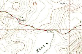
what map is this
topographic lines
what map is this
cartogram

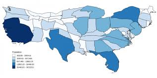
what map is this
choropleth
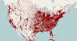
what map is this
dot density
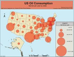
what map is this
proportinal symbol