3- distinctive landscapes
1/53
Earn XP
Description and Tags
Name | Mastery | Learn | Test | Matching | Spaced | Call with Kai |
|---|
No analytics yet
Send a link to your students to track their progress
54 Terms
what is a landscape?
comprises all visible features of an area of land
main elements of any landscape
physical- like mountains/valleys
water- rivers/lakes
living- trees/grass
transitory (temporary)- weather/seasons
human- buildings, other land uses
natural landscape vs built landscape
a natural landscape has more physical features e.g. mountains/ forests
a built landscape has more visible human features e.g. a town/city
upland areas distribution
north and west UK
lowland areas distribution
south and east UK
glaciated landscape distribution
north and west UK
features of an upland area
formed of harder rocks that resist erosion (e.g. slate, granite, limestones)
many are glaciated
gradient is steep
cooler, wetter climate
low temperatures
often mountainous
harsh climate and thin soils are good for vegetation
land uses- sheep farming, quarrying, tourism
features of a lowland area
made from softer rocks (e.g. chalk, clay, sandstones)
landscape flatter with gently rolling hills
warmer drier climate
milder temperatures
not high above sea level
vegetation grows easily in fertile soils
land uses- quarrying, tourism, dairy/ arable farming
urban areas and industries found here
features of a glaciated landscape
weathering
break down/ dissolving of rocks
freeze- thaw weathering
water enters cracks in rocks and when temperatures drop, the water freezes and contracts putting pressure on the rock. the ice melts, making its way deeper into the crack. repeated freezing and thawing causes the rock to widen until it splits
chemical weathering
breakdown of rock by changing its chemical composition
this happens when theres a reaction between water and the atmosphere, CO2 reacts with water making acid rain which weathers down rocks like sandstone and limestone
biological weathering
breakdown of rock by living things
movements of plants and animals e.g. a rabbit could burrow into a crack in a rock or a plant could grow making it bigger, eventually splitting it
mass movement
the movement of material downhill due to the force of gravity
examples of mass movement
rock falls
landslides
slumping
soil creep
erosion
process in which rocks are broken down by natural forces e.g. wind/water
4 types of erosion
hydraulic action
attrition
abrasion
solution
hydraulic action
waves crash against the coast, compressing air into the cracks. this puts pressure on the rock, repeated compression widens cracks and makes bits of rock break off
attrition
pebbles are picked up by waves and bash into each other, wearing down into smaller rounder particles
abrasion
waves pick up rocks from the seabed and smash them against the coast wearing them away
solution
rocks like limestone slowly dissolve in water due to dissolved co2 in the rivers/ sea which make the water slightly acidic
4 types of transportation
traction
saltation
suspension
solution
traction
large boulders and stones are dragged along the river bed/ sea floor due to the force of the water
saltation
pebble sized particles are bounced along the river bed/sea floor due to the force of the water
suspension
tiny particles of silt/sand/clay are carried along by the flowing water
solution
soluble materials dissolve in the water and are carried along invisible to the eye
constructive waves
steep beach profile
smaller wave height
strong swash moves sediment up beach
weak backwash carries away little sediment
less frequent waves
destructive waves
gentle beach profile
larger wave height
weak swash moves little sediment up beach
strong backwash carries away lots of sediment
steep angle of wave break scours material away
waves break less often due to shallow wave angle
more frequent waves
headlands and bays formation
headlands and bays are formed where there is alternating bands of resistant and less resistant rock along a coast
the less resistant rock is eroded quickly, forming a bay with a gentle slope
the resistant rock is eroded more slowly and is left jutting out forming a headland with steep sides
what do headlands form
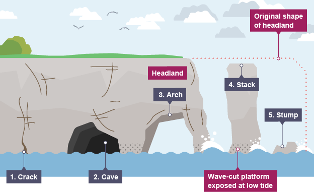
headlands are eroded to form caves, arches, stacks and stumps

cave
headlands are made of resistant rocks that have weaknesses like cracks
waves crash into the headlands and enlarge the cracks mainly by hydraulic action and abrasion
repeated erosion+ enlargement of the cracks causes a cave to form

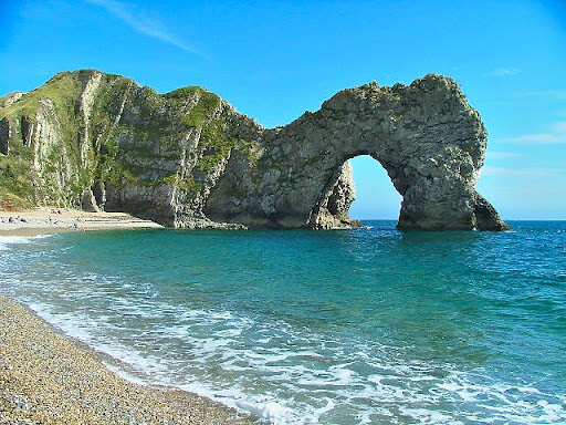
arch
repeated erosion deepens the cave until it breaks through the headland forming an arch

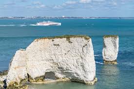
stack
erosion continues to wear away the rock supporting the arch until it eventually collapses which forms a stack -an isolated rock separate from the headland
stump
the stack is eroded forming a stump
coastal deposition
when the waves do not have adequate energy, they drop the sand, pebbles & rocks they are carrying
beaches formation
beaches form in sheltered environments such as bays. when the swash is stronger than the backwash, deposition occurs
spit
a coastal landform, a stretch of land that projects out to the sea and is connected to the mainland at one endcha
characteristics of a spit
curved end
made of rock, sand and pebbles
by a river estuary
thin
narrow
how a spit is formed
material is carried along the shore in a zigzag motion by waves as they swash material up the beach at an angle and then backwash the material down the beach at a right angle. the angle of the swash is decided by the prevailing wind.
where theres a break in the coastline then material is deposited closest to the shore
over time this material builds up out to sea forming a spit
a spit generally curves inwards towards the land as a result of the prevailing wind
hard engineering
using artificial structures to control the forces of nature
soft engineering
fitting in and working with the natural coastal processes
mouth
where a river flows into the sea or a lake
source
the area in which the river begins
confluence
where 2 rivers join
watershed
the area of high land forming the edge of a river basin
tributary
a smaller river that joins a larger river
upper course landforms
v shaped valley
waterfall
gorge
formation of a waterfall
forms where a river flows over an area of hard rock followed by an area of soft rock
softer rock is eroded by hydraulic action and abrasion more than the hard rock creating a ‘step’ in the ruver
as water goes over the step, more and more of the soft rock is eroded
a steep drop is created called a waterfall
the hard rock is undercut by erosion. its unsupported now and collapses causing a plunge pool
the collapsed rocks that fall into the plunge pool act to erode it further by abrasion
a gorge is formed. this takes thousands of years until the whole process starts again causing a retreat upstream

v shaped valley
a small stream will naturally follow small depressions in the landscape
as the stream flows downhill steeply, the bedload erodes downwards and scrapes away the bottom of the channel (this is vertical erosion)
vertical erosion deepens the valley making the sides more exposed and steep
over time, gravity and weathering wear away steep valley sides forcing material into the stream which cuts the valley deeper
middle course landforms
wider valleys
meanders
ox-bow lakes
formation of a meander/ ox-bow lake
time and disturbance causes a bend.
the water’s momentum slams against the wall causing more and more bends
the outside bend begins to erode
this causes the gap to narrow
hydraulic action
the river is lazy/idle and doesn’t flow through the bend
when in flood, the river will break through the narrow gap
the current along the straight path is more dominant
the old path is now dry and deposition from the upper course has built up
abandoned meander
lower course landforms
flood plains
levees
ox-bow lakes
flood plain
the land is flat with a large flood plain next to the river. material is deposited in this course, when the river floods, it deposits silt/ alluvium which is good soil for farming
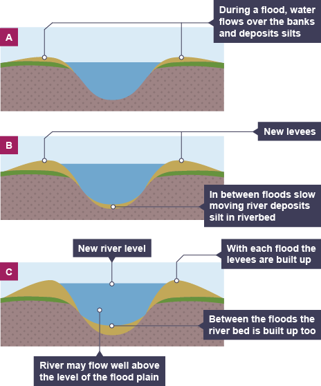
levees
when the river floods, it spreads water and alluvium across the flood plain. a layer of alluvium builds up on the flood plain, deepening it. the levee now raises the height of the river bank. the river returns to its normal level.
