AP HUG Unit 6
 Call Kai
 Learn
Learn Practice Test
 Spaced Repetition
 Match
Match Flashcards
 Knowt Play
1/103

Earn XP
Description and Tags
self study
Name | Mastery | Learn | Test | Matching | Spaced | Call with Kai | Chat |
|---|
No analytics yet
Send a link to your students to track their progress
104 Terms
What is Unit 6 all about?
Urbanization, the effects of urbanization & its infrastructure & its sustainability, world cities & globalization, urban models (7 of them), how population density affects land use policies, how to keep cities sustainable, smart growth policies, how qualitative and quantitative data is used for urban policies, gentrification, and challenges to urban change
Site
Physical geographical location on Earth - absolute location
Situation
The way urban areas are connected to other urban areas - relative location
Urbanization
All the various factors that cause cities to grow and function
What does situation determine for cities?
Situation determines a cities function
Urbanization influences
Transportation technology
Communication technology
Population growth and migration
Economic development
Government policies
What transportation technology advancements could influence urbanization?
The street car
Later on, it is the automobile
What does the automobile create as a result of its invention?
The automobile creates suburbs as a result of its invention
What communication technology could influence urbanization?
The telegraph and telephone
What government policies could influence urbanization?
Zoning restrictions, which determine what areas are allowed to do
Urbanization rate
The percentage of a country’s population that lived within the bounds of urban areas
Sprawl
Geographic expansion of an urban area with little to no planning
Suburbanization
Resettlement of urban residents to the outskirts of cities
Edge city
A new land use form that creates a semi-independent community. This land use form is found at the edges of cities with downtown areas, housing, etc
What is unique about edge cities?
They are uniquely American and self-sustaining
Exurb
A new land use form found outside the suburbs with more abundant land
Who typically lives on exurb land?
They are typically lived on by wealthier people
Boomburg
A new land use form that is a suburb that has experienced rapid growth (100,000+ residents) and becomes a city in itself
Megacities
Urban area that contain a regional population of over ten million
What is considered a region for cities?
The metropolitan area (city + suburbs)
Metacities
Urban areas with a regional population of 20+ million
Why are Metacities important?
They are important because they have great influence
World cities
They tend to be the headquarters of multinational corporations, stock exchanges, etc
What do world cities act as?
They act as nodes for political, cultural, and economic diffusion around the world
Examples of world cities
New York
London
Paris
Shanghai
How do world cities drive globalization
World cities drive globalization through efficient transportation, communication systems, and cultural innovations
Urban hierarchy
ranking of various cities - the most powerful and influential hold top spots, which the least powerful and influential are near the bottom
Rank
Size rule - explains the distribution of a country’s cities based on proportional population
The largest city acts as the baseline, where the rest are ranked according to it
Why does Rank only work in developed countries
they have highly distributed wealth, decentralized economies, and interconnected urban systems
They have decentralized urban hierarchies, meaning goods, services, and economic opportunities are spread across multiple regional hubs rather than concentrated in a single city
What does the size rule act as?
It acts as more of a suggestion rather than as a fact because urban growth is based off of political, cultural, and economic reasons, not purely from a mathematical point of view
Primate city rule
In developing countries in the periphery and semi-periphery, where primate cities exist, there will be very few other large/medium cities
Where does the primate city rule apply?
It can apply to a developed country, but les often
Gravity model
It explains the pattern of interaction between two cities
closer = more interaction
Size = larger = strong connection
How can the gravity model explain how two large businesses far apart from each other have a stronger connection with each other than two local places?
Two large businesses can have a stronger connection because they are much bigger than local organizations, which creates a strong connection
Christaller’s central place theory
It explains the size and spatial arrangement of cities, towns, and other settlements in an area
Central place
A settlement with the purpose of giving people goods and services
Threshold
The number of people needed to support a good/service
Range
Distance people are willing to travel to spend money on a good/servicec
Low-order goods and services
They have low range and threshold because they are common items (toilet paper, food, water, etc)
High-order goods and services
High range and threshold because they are luxury items
Limitations of the Christaller central place theory?
It assume flat land and no barriers
It assume settlements are arranged because of a person’s economic decisions
No account for development of transportation technology
What is the importance of urban models?
They can tell the city’s internal structure
What three entities are all cities made up of?
A central business district
An industrial/commercial district
Resident locations
Important facts about urban models
Each model has strengths and limitations
Innovations in transportation led to newer models being created
Why are different sectors located where they are & their relationship with each other
How does the bid-rent theory explain the models spatial arrangement
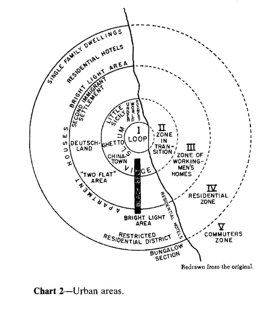
Burgess Concentric Zone
The first of four models, which are used to better understand North American city’s internal structure
It has five parts: the CBD, Factory Zone/zone of transition, working class zone, residential zone, and commuter zone
The model are multiple circles that spread out from the center, with the CBD in the middle
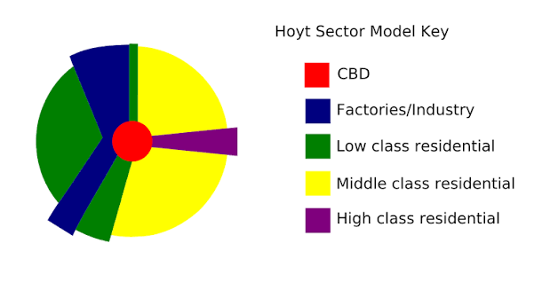
Hoyt sector model
The second of four models used to better understand North American city’s internal structure
It has four parts: the CBD, a high class residential area, middle class residential area, and low class residential area
It was created because it sought to address the burgess model by adding direction as a determining factor
What does the hoyt sector model’s wedges correspond to?
It corresponds to major transportation routes
What two major innovations drove the hoyt sector model?
The electric street car and elevated trains
where is housing built in the Hoyt sector model?
Housing is built along transportation routs rather than in concentric circles
Limitations of the Hoyt secotr model
It assumes city development to be a predictable manner
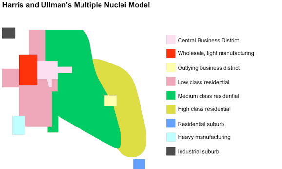
Multiple Nuclei model
The third model used to better understand North American city’s internal structure
This model argues that city development grew from several different nodes & that growth occurs independently around different focal points/nuclei
What are the three factors for multiple nuclei in the multiple nuclei model?
Specialized activities require specialized land and infrastructure
Economic benefits for companies - financial sectors or business districts
Negative consequences led to new nodes - noise and pollution
What are the limitations of the multiple nuclei model?
Over time, nuclei borders blend together with their surroundings, causing distinct nuclei to be hard to identify
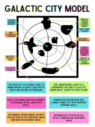
Galactic city model
The fourth model used to better understand North American city’s internal structure
This model developed as a response to the rise of urban sprawl, in which edge cities develop and beltways connect places
Limitations of the galactic city model
It is becoming more obsolete with the rise of the internet, which makes beltways less important
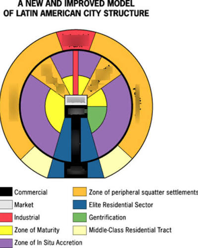
Latin-American model
Based on Mexico city, this model has higher residence close to the spine
The outside edges have little to nothing
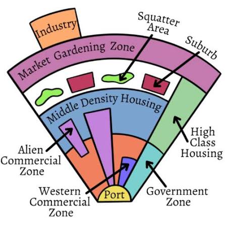
Southeast Asian model
Organized around a water-based trading port, this model is unique because it has a market gardening zone that accommodates agriculture
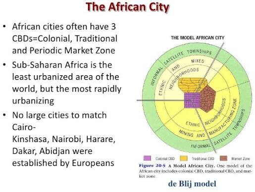
Sub-Saharan African model
A unique urban model that has three Central Business Districts, where surrounding CBD’s are ethnic neighborhoods
Population density
Measure of how many people occupy a given unit of area
Land use
assigned function of a given unit of urban land
Zoning regulations
laws that dictate how land can be used in residential, commercial, industrial, and other areas - they determine what can be built
What cultural factors shaped city spatial development?
Racist segregation and white flight
Infilling
Development of underdeveloped/underused land inside urban areas - done for commercial or residential use
What is land considered in cities?
Land is a commodity in cities, meaning it is limited
City governments find wats to fill/use that land
Infrastructure
All systems and structure that support a population in aplace
Examples of infrastructure
roads, power lines and stations, internet access, hospitals, schools, etc
What does infrastructure dictate in cities"?
Infrastructure heavily determines a city’s quality of life, meaning they play a role inch city arrangement and development
Why is it hard to raise the standard of living in peripheral & semi-peripheral countries?
They lack the fund to improve infrastructure
Sustainability
The use of resources sot hat an urban society is habitable while also ensuring that resources are available to future generations
cities = resource hogs
Ecological footprint
Amount of land required to support a given populations use of natural resources
Smart growth policies
Initiative from urban pioneers that fight urban sprawl, which is done by emphasizing environmental protection and compact, walkable neighborhoods with public transportation, etc
What do smart growth policies want?
Mixed land use - neighborhoods with diverse functions
Walkable neighborhoods - sidewalks
Diverse housing options - prevents racial problems
Protection of natural environment - infrastructure created with the environment in mind
New Urbanism
Quality architecture - variation in buildings
Smart transportation
Greentbelts
Slow growth cities
New Urbanism
It focuses on neighborhoods, with similar goals to smart growth policies
This basically wants European style neighborhoods with dense populations
Greentbelts
Circular area of trees, forests, etc that surround cities and act as a formal barrier between urban and rural places
This creates a place to enjoy nature while also taking in city carbon emissions
Slow growth cities
Urban areas that use zoning laws to slow urban sprawl
How do zoning laws slow down urban sprawl
City governments use zoning laws to limit the spread of cities & city planners can build high density residence buildings to combat the negative effects of sprawl
Various responses to smart growth policies
Quality of life improvement achieved
Creates new problems without living up to promises, such as increasing housing costs
De facto segregation
Loss of historical or place character
How do government decisions impact?
Government decisions impact the quality of life and development of cities
How does the government use quantitative data to impact the quality of life for its citizens?
The government collects census data, letting them know the population composition and size of urban areas - can be used to influence certain policies created
Analyzing data is useful in specific situations
How does the government use qualitative data to impact the quality of life for its citizens?
The govt. could interview residents to gather how people feel about certain decisions, which adds personal feelings to numerical decisions
redlining
A practice still present today (fueled by racism), which dates back to the 1930s in the U.S., where banks marked high risk urban areas on a map with red lines and reused to lend money to people wanting to buy houses/obtain home-improvement lands in those neighborhoods
Blockbusting
A practice in which real estate agents sowed fear into white homeowners by persuading them that their neighborhood were becoming unsafe due to black families moving in
House affordability
The max price a buyer can afford when purchasing a residence
This is influenced by redlining and Blockbusting
Challenges surrounding access to services
Lower income people struggle to gain access to policing, fire department, and public welfare services, as well as other services
Rising levels of crime
A social problem, in which it is a phenomena characterized with racial discrimination
Environmental injustice
A social problem, in which a city’s poor and immigrant population bear the negative effects of hazards to the environment (pollution) at a higher rate than wealthier groups
Disamenity zones
Places where no amenities like running water or sanitation exist - found in cities of peripheral countries
Zones of abandonment
Areas of a city that are completely abandoned because people can’t afford it or because of environmental disasters
Squatter sett;e,emts
temporary and often illegal housing found on the outskirts of urban areas in peripheral countries
Gentrification
The process by which deteriorating areas in the city are rebuilt and renewed t offer high quality housing
The problem with gentrification
Lower income folks can’t afford to live in the gentrified areas any more
Pros of Gentrification
It revitalizes urban areas
governments recover tax dollars as the wealthy move in
The government can provide services to the community
Cons of Gentrification
Majority of people dislocated because of low income
Harder access to services if low income
Fragmented governments
The power of government split from state to state and to smaller branches of government - it tries to fix problems, but this just makes it harder for the government to coordinate with each other
Inclusionary zoning
A response to fragmented governments, in which they are policies enacted by municipal governments that require new developments to include affordable housing to law and moderate income residents
Benefits of inclusionary zones
If done properly, it could reverse class and racial division
Criticism of inclusionary zoning
Even if housing prices go down, low income families might not be able to afford local amenities
Local food movements
The encouragement for low-income communities to grow their own food in urban gardens - sponsored by non government organizations
They give low income residents access to fruits and vegetables
Why is urban sustainability hard?
Suburban sprawl - land is cheaper when farther away from the city
Sanitation - garbage and human waste, cities produce a lot of it
Climate change - increase temperature, cities create a low of heat
Air & water quality - available water could be polluted & smog could be created (clouds vision and can cause respiratory problems)
Regional planning efforts
A sustainability initiative, in which regional authorities can collaborate to create plans to increase sustainability in urban areas