The formation of typical river landforms
1/19
There's no tags or description
Looks like no tags are added yet.
Name | Mastery | Learn | Test | Matching | Spaced | Call with Kai |
|---|
No analytics yet
Send a link to your students to track their progress
20 Terms
Deposition
the laying down of sediment carried by wind, flowing water, the sea or ice.
River discharge
the volume of water flowing through a river channel; measured at any given point in cubic metres per second
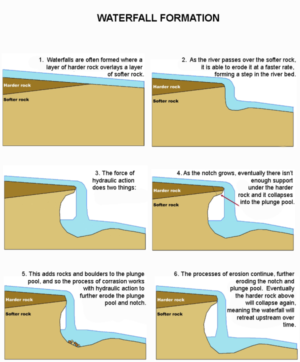
Waterfall (formation)
Waterfalls form in areas where the river crosses a band of harder rock
As the river flows over the landscape, it erodes the softer rock more rapidly, creating a step or sudden drop in the riverbed.
As water cascades over the edge, it creates a plunge pool at the base of the waterfall.
The plunge pool is deepened over time and begins to undercut the soft rock beneath the hard rock. With no support, the hard rock collapses and retreats.
Over thousands of years, the waterfall may retreat enough to form a gorge.
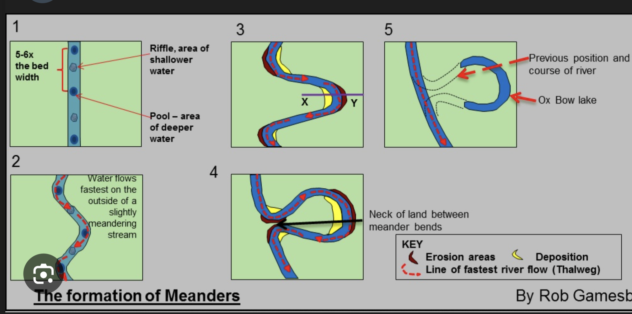
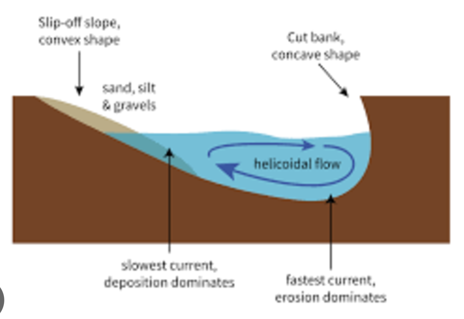
Meander (winding/sinuous, steep river cliff)
A meander is a winding/sinuous section of a river with a steep river cliff on the outside bend
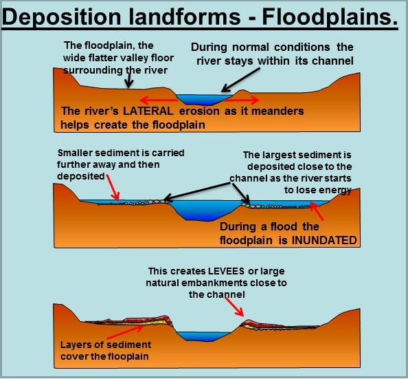
Flood plains (process)
The river transports sediment downstream. When the river floods, it transports the sediment over an area adjacent to the river, depositing largest sediment almost immediately on the sides of the river bank whilst small sediments are carried further away
The small fine sediments will help to rise and build the flood plains
The flood plains rise over time as a result of sediment built up, which raises the river channel
deposition landform
Meanders (process)
As the water flow from the upper course to the low course, the water travels faster (thalweg) on the outside bends, which creates erosion through abrasion and hydraulic action. This flow is the helicoidal flow
River cliff are formed when faster moving water on the outside of a bend erodes away at the rock, undercutting the bank
Water moves slowly on the inside of the bend and the river deposits some load, creating the point-bar, that is a slip-off slope
The deposition and erosion on the inner and outer banks of the river form a meander.
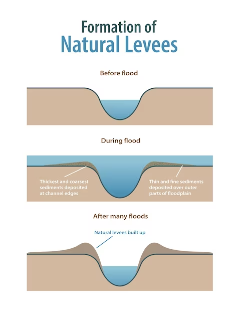
Levees
Levees are raised banks at the edge of a river.
The river transports sediment downstream. When the river floods, it transports the sediment over an area adjacent to the river, depositing largest sediment almost immediately on the sides of the river bank wears small sediments are carried further away
The larger sediments will build up the levees

Deltas (progadation)
Rivers carry a significant amount of sediment—such as sand, silt, and clay—As the river nears its mouth, the flow of water slows down, causing the river to deposit its sediment load.
At the river's mouth, the river may split into multiple channels called distributaries.
As the velocity of the water decreases in the distributaries, the sediment carried by the river is deposited.
Over time, repeated deposition of sediment builds up the delta in a process called progradation. As sediment accumulates, the delta extends outward into the body of water.
Gorge (narrow valley)
a narrow valley between hills or mountains, typically with steep rocky walls and a stream running through it.
Oxbow Lake
As the water flow from the upper course to the low course, the water travels faster on the outside bends (known as thalweg), which creates erosion through abrasion and hydraulic action
This forms a river cliff whilst water the travels slower on the inside bend causes deposition and a slipp-off slope.
This process of erosion continues over time, which causes the bend to be more extreme and exagerated.
As the bend become more extreme, the rivers current will begin to erode the neck of the meander, known as lateral erosion
Over time, continual erosion and deposition narrows the neck of the meander.
if the area floods, this area is cut through and the river continues on a straighter path
Meander is therefore abandoned as new deposition seals off the ends, cut off area of water becomes oxbow lake
An oxbow lake is left behind
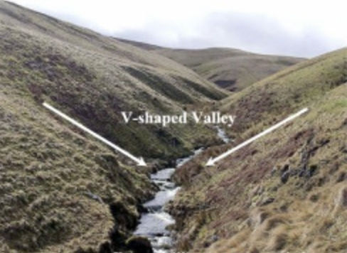
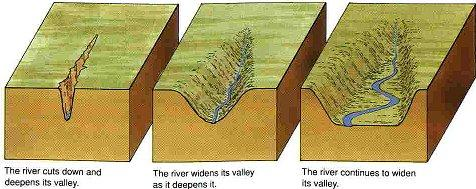
V-shaped valleys
River sources start in the mountains, The flow downhill eroding away the landscape.
Deep notches in the sides of the river valley are created by hydraulic action
Freeze thaw weathering exposes the sides of the valley. Rocks are loosened and the valley sides steepened, loosens the rocks (some may fall into the water flow) and steepens the valley sides.
Fallen rocks within the river erode for further through corrasion
The rocks are moved downstream. This widens and deepens the channel. Creates v shaped valley
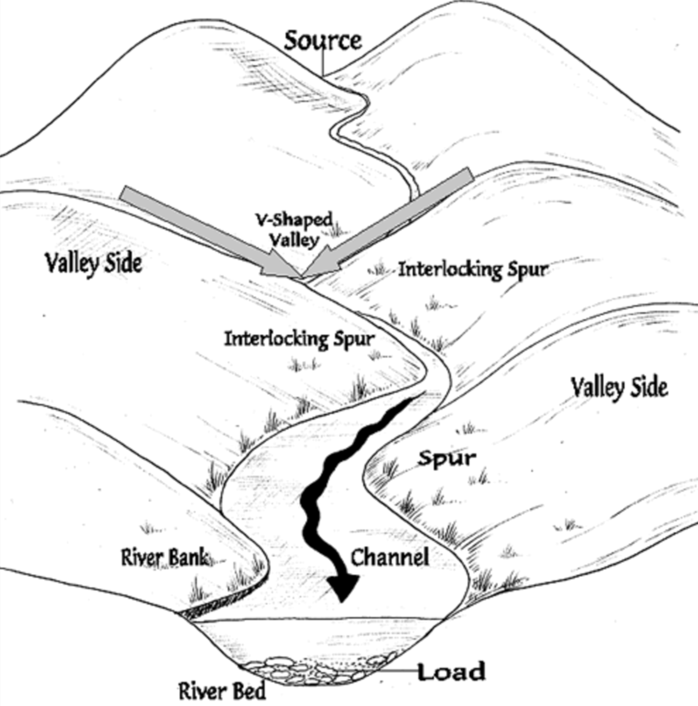
Interlocking spurs
Alternate hills that stick out in the river’s path. The river cuts down into the valley to form a narrow steep-sidedd V shape valley. If there are areas of hard rock which are harder to erode, the river bend around it. This results in land interlocking -- interlocking spurs
A scree
formed as a result of freeze-thaw weathering. Water seeps into cracks in the rock, expanding when it freezes and seeping in deeper when it melts, gradually splitting the rock apart a slope covered with small loose stones.
Depositional Landform
depositional landform that occurs on the inside convex bank of a meandering river
Alluvium
a deposit of clay, silt, sand, and gravel left by flowing streams in a river valley or delta, typically producing fertile soil.
Alluvium
erosion of sediments?
The eroded material is then transported by the moving water downstream. Larger particles like gravel and boulders settle out first, while smaller particles like silt and clay can be carried further.
When the velocity of the water decreases, such as on floodplains or in river deltas, the sediment is deposited. This deposition process forms layers of alluvium over time.
Uses of alluvium
Alluvial soils are highly fertile due to their composition of minerals and nutrients. They are often used for agriculture and farming, as they support the growth of a variety of crops.
Types of deltas
Bird’s foot
Arcuate

Estuaries
the tidal mouth of a large river, where the tide meets the stream.
useful for shipping
terraces
a flat or gently sloping geomorphic surface