Hot deserts
1/72
There's no tags or description
Looks like no tags are added yet.
Name | Mastery | Learn | Test | Matching | Spaced |
|---|
No study sessions yet.
73 Terms
where are hot deserts located?
roughly 30 degrees north and south of the equator
tropics if cancer and Capricorn
area of high pressure with dry air, little rainfall or clouds
what are the three types of desert landscape?
Hamada - bare rocky surface eg plateux
reg - stony desert with rock fragments scattered over a large area
erg - predominantly sand (‘sand sea’)
* solar radiation
* descending air in the ITCZ
what are the outputs and stores of a desert system?
outputs = water, sediment and reradiation from earth’s surface into atmosphere
stores = landforms, vegetation and soils
what are the processes/flows in a desert system?
isolation, oxidisation, wind action, wind erosion, transport, overgrazing, water management
what are the feedback loops in a desert system?
positive = absence of vegetation can affect the climate as less evapotranspiration, this leads to drier climate with less rainfall, lead to less vegetation
dynamic equilibrium = seasonal cycles of wind can lead to small scale and short term adjustments in sand dune profiles, but year to year their shape stays relatively the same
what atmospheric processes are related to the distribution and aridity of hot deserts?
global atmospheric circulation
air rising in the intertropical convergence zone sdreads north and south at the tropical hadley cells
due to the sinking between the hadley and ferrel cells air become drier and warmer creating a belt of high pressure (30 degrees north and south)
causes cloudless skies and lack of rainfall. therefor there is extreme temperatures - aridity
what is aridity
severely dry climate
briefly explain the importance of latent heat in the desert?
water evaporated and changes from liquid to gas using latent heat from the environment, causing a drop in temp
opposite occurres during condensation when heat is expended
in dry climates evaporational cooling is minimum in daytime (no moisture) so there are very high temps
at night there is little water vapour to trap longwave radiation so there is rapid cooling
How does continentality effect aridity?
aridity is higher in continental interiors eg central africa asia and australia.
due to reduced influence from moist airstreams from oceans
continental exterior deserts tend to be semi-arid as occasional storms can bring rain
How does relief effect aridity?
prevailing moist ocean winds can be forced up mountains
this means it is forced to rise and cools creating precipitation that mostly falls on the windward slopes
after precipitation the cool air sinks back down the sheltered side of the land drying and warming - creates a band of high pressure
this is called a rain shadow
How do cold ocean currents affect aridity?
some deserts are on coastlines of cold ocean currents eg (Atacama desert)
air that is in contact with the ocean currents is cooled and being denser and cooler than the warm air, remains close to the ground
the air passing over the oceans onto the land is also cool and unable to pick up moisture meaning the land remains very dry with little ability to form precipitation
what are some distinctive aspects of the water cycle in hot deserts?
rainfall low and sporadia (mostly occurs in heavy downpours causing overland flow and high evaporation)
actual evapotranspiration is low however rates of potential evapotranspiration are very high (up to 10x annual precip)
rivers have distinctive sources: exogenous, endoreic and ephemeral
What is the aridity index?
most common measure of aridity
ratio between annual average precipitation (P) and average annual potential evapotranspiration (PET)
arid areas have a ration of less that 0.2 = rainfall supplies less that 20% of water needed for optimum plant growth
semi arid = 0.2-0.5
What is the hot desert water balance?
relationship between precip, soil moist storage, evapostans and runoff
precipitation = evaporation ± soil water storage + runoff
What are the three main energy sources in hot deserts?
insolation - the amount of heat (shortwave radiation) that reaches the earth’s surface - this is high in deserts leads to
intense weathering due to extreme temperatures
high rates of PET
variable warming creating localised winds
water - following infrequent storm can flow in a sheet or in wadis, erosion very significant in a short amount of time.
wind - driven by the atmospheric circulation system. 20-25% of desert surfaces made from sand/small sediment that can be transported by wind.
What are some sources of sediment in hot deserts?
mass movement (rockfalls)
sand/finer sediment carried into desert by winds
erosion of rocks
weathering
What are sediment cells and their componenets?
the movement of sediment, commonly applied to coastal environments, that has….
inputs - sediment
outputs - sediment transported away from desert (wind/water)
sediment sinks - areas of deposition
transfers - movement of sediment (wind/water)
What is the sediment budget?
considers relative amount of sediment in each part of hot desert system.
What are the two main types of weathering in hot deserts?
mechanical (physical) = gradual disintegration of rocks without any chemical change
chemical = change in rocks due to chemical action, usually in the presence of water
What is the most common mechanical weathering in hot deserts?
thermal fracture (insolation weathering)
caused by intense temp fluctuations, where rock expands when heated and contracts when cooled
believed to be due to the presence of moisture eg dew
dependent on colour, lithology (rock type) and geological structure
less common include…
salt crystallization due to evaporation of salts dissolved in soil forms layers on surface that can break rocks
frost shattering, due to temp below freezing, water freezing in cracks and expanding causing breakage
What are the 4 types of thermal weathering?
block separation - if rocks have clear pattern of joints whole blocks will break off
shattering - rocks without joints or fragments to shatter of into angular fragments
exfoliation - repeated heating and cooling on surface of rock causes peeling or flaking
granular disintegration - crumbling or break down into individual grains
what is chemical weathering
due to chemical action rocks change in the presence of water
rocks containing salts are vulnerable to being dissolved (solution) leading to crystal growth which can damage and corrode buildings
What are the two main types of wind erosion in hot deserts?
deflation = removal of loose material from desert floor, resulting in exposed underlying rock. over time leaving behind only larger sediment
abrasion = ‘sandpaper effect’. wind is blown against rock surfaces, carving or sculpting them into various shapes, mainly occurring within m of the desert floof
What are the 3 types of wind transportation?
surface creep = particles rolled along the floor
saltation = sand particles move in series of leaps as they are picked up and dropped by gusts of wind
suspension = fine sands and clays picked up and carries for considerable distances, potentially out of the deserts, common in high velocity winds
How does wind deposition operate in the desert?
occurs when wind velocity falls below critical value where it can carry and move sediment
common that sediment will be deposited in sheltered areas from the wind like the leeward side of a rock formation
what are the various aeolian landforms?
deflation hollows
desert pavements
ventifacts
yardangs
zeugan
sand dunes
What is a deflation hollow?
depression created by strong winds that erode loose material from the desert surface.
depth is controlled by several factors such as wind dynamics, depth of loose material above consolidated and water table
saturated sand in the hollows can lead to the development of salt lakes etc
What are desert pavements?
or regs
suface covered with rock fragments resembling a cobbles pavement.
finer sand is blow away leaving this exposed
common on well developed aluvial fans due to deflation
What are ventifacts?
small scale featured found on desert flood
rock fragments the size of pebbles with an eroded facet (face) aligned with the prevailing wind.
some have a single facet - one wind direction
others have multiple indicating changes in wind direction (multidirectional)
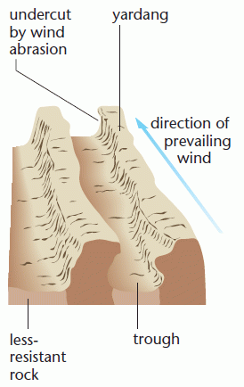
What are yardangs?
elongated ridges separated by deep groves cut into the desert surface
vary in size from cm- 100s of m and km in height
weaker rocks eroded by abrasion to form troughs in the direction of prevailing wind
tougher rocks left upstanding
don’t develop in regions with multidirectional winds
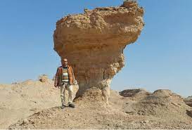
What are zuegen?
similar to yardangs up to 30m high
however develop in horizontally layered rocks
gives pedestal shape with a flat capped rock
primarily due to abrasion which occurs only a couple meters above floor
means top is often larger
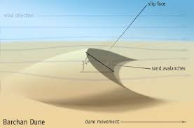
what are 2 common types of sand dune and how to they form?
barchans
a dune develops due to sand deposition, with sand being blown to a crest and then down a slip face which is steeper than the prevailing side
more sand blows around the base of the dune creating a crescent shape (the horns of the dune are extended around the base)
seif dunes
a barchan can develop into one when the wind direction changes and one horn is extended more than another
commonly found in extensive areas of sand (sand seas)
other slip faces may develop as it elongates
How do sand dunes tend to start?
some deposition of sand on the side of a rock. this increases over time depositing more and more sand and being shaped by the wind.
what is desertification?
‘destruction of biological potential of the land resulting in desert-like conditions’ - UN
destruction of ecosystems and habitats
unproductive wasteland
erosion to soil and death of vegetation
where are the most vulnerable locations for desertification?
margins of hot deserts
what are the natural causes of desertification?
CLIMATE CHANGE
natural climate change causes a fluctuation in global climate across the world
8000 years ago north Africa and middle east were much wetter . evidence; fossil aquifers, fossil plant remains.
human induced climate change has increased global temp by 1 degree census since 1880 (greenhouse effect)
What are the human causes for desertification?
over-cultivation = intense farming on land that lacks organic matter and is fragile can reduced soil fertility and cause erosion
overgrazing = if an area has too much livestock living on it, vegetation and soil will suffer as carrying capacity is exceeded
over-irrigation = if plant sare overirrigated causes salts in soil to dissolve and forms a crust on surface when water evaporates (infertile impermeable soil)
population increase = Sahel region doubles every 20 years (population 260 million) meaning land needs to be more productive
firewood = semi-arid regions may rely on firewood used for cooking, unsustainable and exposes soils to erosion
tourism = safaris cause damage to vegetation and soil
What are the impacts of desertification on ecosystems?
loss of nutrients due to over-exploitation by agriculture, reducing biodiversity
loss of top soil which is the most nutritious part of the soil due to exposure to wind and water
increases salinity with irrigation
depleted water sources affecting water table
vegetation destroyed impacting animals and meaning they must migrate
What are the impacts of desertification on people?
lack of water = disease spread and hygiene issues
loss of vegetation = less produce, meaning people abandon settlements
dust clouds affect air quality and effect health for even people far from desert regions
food insecurity (25% of India’s land turning into desert) compromising ability to feed people
depleted grassland means people cannot sustain animals so people migrate to overcrowded cities.
what are the impacts of desertification on landscapes?
sand dunes are created as material is dry and no longer trapped by vegitation
soil erosion can cause deep gullies to form in the landscape
sandstorms become more common when protective vegetation is removed - increased abrasion
landslides due to loss of vegetation
What is the climate of a hot desert like?
many hours of sunshine due to no cloud cover (zones of high pressure)
temperature variations of 30 degrees c day to night due to lack of cloud cover
sandstorms especially in areas with large variation in temp
what are the characteristics of desert soil?
too dry and sandy to support much vegetation so soil is poorly developed (no hummus due to lack of water)
red color due to oxidation with iron rich rocks
very porous and permeable with little water retention however leaching is not a problem so with correct management crops can be grown
What are the characteristics of desert vegetation?
there are some plants that adapt (xerophytes) due to the hostile climates that don’t support growth…
drought avoidance = plants live for only one season, dry up and die in drought season but store the necessary nutrients. some also use taproots
drought resistant = plants adjust their metabolism to be able to become dormant
water storage = succulent plants have shallow roots to quickly absorb water in storm events, stored in fleshy leaves, roots and stems
What is an oasis?
dense pocket of vegetation created by water existing close to the surface
eg water may be trapped due to impermeable layer near the surface resulting in lush vegetation forming important habitats
How is climate change impacting desertification?
by middle of this century world’s dryland may increase in temp by 2-5ºC, accelerating rates of desertification
increased rates of ET
soil water decrease - settlement and agriculture less viable (people migrate) causing a positive feedback loop of desertification then occuring in other areas
droughts more frequent and severe
rainfall decreases as the dryland expands
How can planting trees help desertification?
roots hold soil together reducing risk of erosion
ground gains nutrients due to leaf litter
shade for the soil reducing evaporation and reducing temperatures
great green wall sahel
* crop rotation means nutrients are not stripped from the soil
* local people can make their own compost to help nourish the soil
* for example stone lines across land that is level can trap soil being transported by the wind so it is not eroded
* This also prevents overland flow that strips the nutrients in the soil
How have people in the Badia, Jordan addressed desertification?
desertification in prevalent from overgrazing creating unproductive land.
2002 the tal rimha rangeland rehabilitation project make agreements with farmers to revere this. stone walls were constructed to control and retain water
water was diverted down ditches where drought tolerant shrubs have been planted; they grow quickly, provide firewood, hold soil together and encourage biodiversity.
birds nest in the base of shrubs
animals are returning to the area
sustainable living is now benefiting locals, the land and the economy
what are the 4 main sources of water in Hot deserts?
exogenous rivers = have their source in mountains outside deserts, have sufficient water flow, eg the river Nile despite high evap
endoreic rivers = rivers that flow into deserts but terminate at inland lakes or seas, eg the dead sea
ephemeral rivers = rivers that flow intermittently in deserts, flow after storm events or snow melt. flow rates vary largely and can be strong sources if erosion.
episodic flash floods = infrequent rainfall events that involve torrential convectional storms, lost of water in short period, sunbaked soil means there is lots of overland flow (erosion). sheet flooding or channel flooding.
what are the water processes of erosion in deserts?
hydraulic action - the force of water
abrasion - sandpaper effect of loose rocks
corrasion - fragments of rock carried by water gouging bedrock
solution - dissolved sediment
what are the 4 river processes of transportation
traction = rolling sediment along the channel bed
saltation = bouncing particles
suspension = sediment carried in the body of water
solution = dissolved sediment
what are the 5 sheet wash processes in deserts?
splash erosion - force of falling rain water displacing soil
sheet erosion - water running over a large impermeable surface as overland flow washing particles away
rill erosion - sheet wears away soil to form defined paths (rills)
gully erosion - over time rills become deeper and wider to form gullies
bank erosion - fast water flow wears away channel sides and causes widening
* vary in size and features
* steep edges due to sever erosion in periods of high water flow
* flat bottoms infilled with sediment - boulders, pebbles as finer material is removed by the wind
* there are often many channels that split up and rejoin due to flashy water flow
* as the water spreads from the mountain the larger sediment is deposited due to the reducing energy. this gives the appearance of layering of sized of sediment.
* they can extend several kilometers away from the mountain edge with a thickness of up to 300m.
* they also exhibit clear sorting of sediment
* playas may form on lower bajadas where they become extensive flat deposits
What is a pediment?
gently sloping rock surface at the base of a desert mountain range
low angled and may be completely. covered in sediment or bare
* some of this water will percolate through course sediment and travel as throughflow to a depression where it may form a playa
* this is an enclosed desert lake with no outflow. large surface area will encourage evaporation and a salty crust will often form around the edges
* in some places this salt can be collected and used commercially
* can be formed by exogenous rivers that run consistently over a spot
* grand canyon Arizona due to the Colorado river showing ancient layers of rock dating back up to 2 billion years ago.
what is a mesa
Mesas are table-like raised plateaus with steep sides bordered by wadis or canyons
how have scientists investigated historical extent and distribution of deserts?
carbon dating methods and pollen analysis to study patterns of vegetation
How has the extent and distribution of deserts changed over time?
has remained unchanged for past 5000 years due to relatively stable climate with GAC as the main driving force
8000 years ago - interglacial period with humid warm conditions with widespread forests, low aridity
20,000 years ago - glacial maximum aridity was widespread. deserts in far north were cold and in the south were distributed similar to today but far more extensive