EAPS 5 - Midterm 1
 Call Kai
 Learn
Learn Practice Test
 Spaced Repetition
 Match
Match Flashcards
 Knowt Play
1/74

There's no tags or description
Looks like no tags are added yet.
Name | Mastery | Learn | Test | Matching | Spaced | Call with Kai | Chat |
|---|
No analytics yet
Send a link to your students to track their progress
75 Terms
Differentiation of the Earth
The process when the planet separated into its distinct layers during the formation of the Earth 4.6 Ga
Based on physical and chemical properties (like density and heat!)
The heat in the middle of the planets caused elements to differentiate and separate → lighter
Accretion
When the gravitation pull of the early sun swept nebular dust → elements released into space (Fe, Ni) came together, or accrete
Planet building
Layers of the Earth
Inner Core
Outer Core
Mantle
Crust
Inner core
Solid most inner layer of the Earth
Made up of solid iron and nickel material (Fe, Ni)
Outer core
Made of liquid Fe and Ni that convects → creating Earth’s magnetic field
Only liquid layer in Earth’s interior
Mantle
Thickest layer of the Earth (84% of the volume of our planet)
Made of dense rock material
Oceanic crust
Dense crust layer that subducts under less dense continental crust
Made up of basalt
Formed at mid-ocean ridges through seafloor spreading (where magma rises, cools, and forms new crust)
Continental crust
Less dense outer crust layer; thicker than oceanic crust
Made up of granite
Plate tectonic causes the crust to constantly move
Lithosphere
Includes the crust and mantle
Mechanical properties: Strong, made of cool rigid rock; supports all life on Earth
Gets strength from it’s cool nature, making it rigid
Cooling by conduction only
Asthenosphere
Underneath the lithosphere; divided by temperature property
Mechanical properties: Weak because of its warm nature, meaning it can flow
Cooling by conduction and convection
*Tectonic plates from the lithosphere float on top of here
Conduction
The transfer of heat through direct physical contact
Convection
Transfer of heat through the movement of fluids (liquid or gas)
Compositional subdivisions of the Earth
Crust, mantle, core
Rheological subdivisions of the Earth
Asthenosphere, lithosphere
Rheo = greek word for flow or current
Oldest rock on Earth + How we know this
Acasta gneisses
Known because of radiometric dating (U-Pb) of zircon crystals
Zircon
Good for radiometric dating: locks in uranium when it forms and does not reset when subjected to heat/pressure
Radiometric dating
Process that calculates the absolute age of rocks by measuring the decay of unstable radioactive isotopes (parent atoms) into stable isotopes (daughter atoms)
Method that helped us figure out the age of the Earth (4.567 Ga)
Half life
Time it takes for half of a population of radioactive parent atoms to decay into daughter atoms
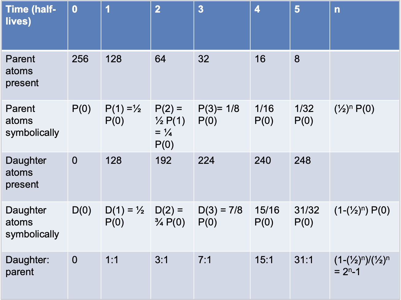
In one half life, ½ of atoms decay
Ex: 256 → 128 → 64 → 32 → 16 → 8 → 4 → 2
Why is C-14 useless for dating rocks?
It’s half-life is too short for rocks (5,730 years too short for dating deep time)
Only useful for once living things: 14C is formed in the atmosphere and found in living things → when they die they stop taking in C and the 14C/12C decreases
Plate boundaries
When two lithospheric plates end up next to each other
Precision
How tightly a number can be specified
The uncertainty of a number is equal to half of its last digit
Ex: 1.01 → (± 0.005) ; 2.2 → (± 0.05)
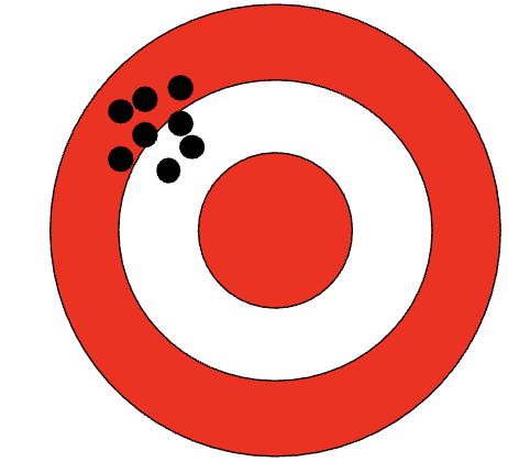
Accuracy
The degree to which a number is actually correct
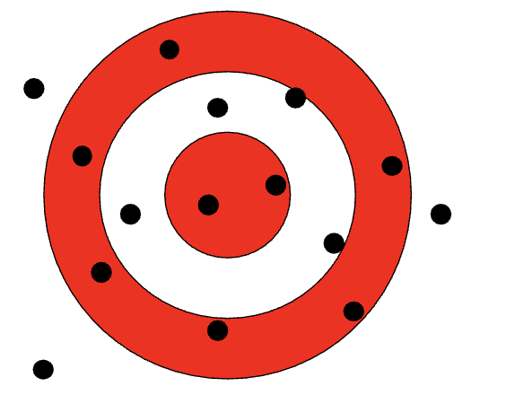
Significant figures
The number of sig figs should have the same sig figs as the least significant number in the calculation
Number of sig figs implies precision!
Mid-ocean ridge
Magma upwells from mantle → cools into basalt → creates new oceanic crust/ lithosphere
Process known as seafloor spreading
Divergent boundaries
When tectonic plates move apart
Occurs mostly in the ocean to build new oceanic crust through mid ocean ridges
Creates mid-ocean ridges and volcanoes
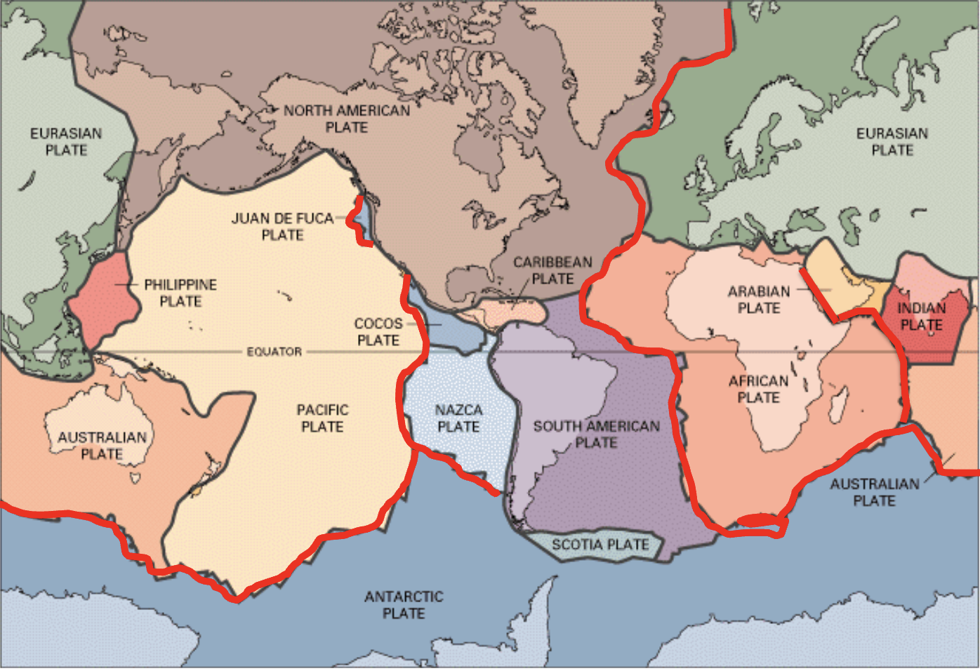
Convergent boundaries
Creates volcanoes and mountain ranges
Oceanic-continental
Type of convergent boundary
Denser oceanic plate subducts beneath less dense continental plate
Forms earthquakes and volcanic mountain ranges
South America
Oceanic-oceanic
Type of convergent boundary
Two oceanic plates collide → older plate subducts beneath younger one
Forms island arcs (chains of volcanic islands)
Japan/Phillippines
Continental-continental
Type of convergent boundary
Both continental plates are too buoyant to sink → crumple upwards
Creates mountain ranges (NO VOLANOES)
Ex: the Himalayas, Alps
Transform boundary
When two plates slide past/against each other
Neither create/destroy crust, just cause friction
Creates fault lines that trigger earthquakes
Oceanic crust
Thin and dense
Basalt
Younger than continental because of mid-ocean ridges
Subducts beneath continental crust
Youngest oceanic crust found:
Near continental margins (close to continents)
Near mid-ocean ridges
Continental crust
Less dense but larger in size
Sits on top of oceanic crust because of density difference
Granite
Old!
Continental drift
Theory created by Alfred Wegener in 1912 to explain why continents appear to fit together
Wegener proposed that all continents were once a supercontinent, Pangaea
Early evidence of continental drift
Shape of continents: look like they fit together
Age of rocks: Geological structures like the Appalachian mountains aligned perfected with age&rocks in Europe
Fossil correlation: Identical creatures were discovered widely spread, despite the fact that they don’t swim
Continental glaciation: Location of glaciation is the same today
Symmetry of magnetic reversal on ocean floor
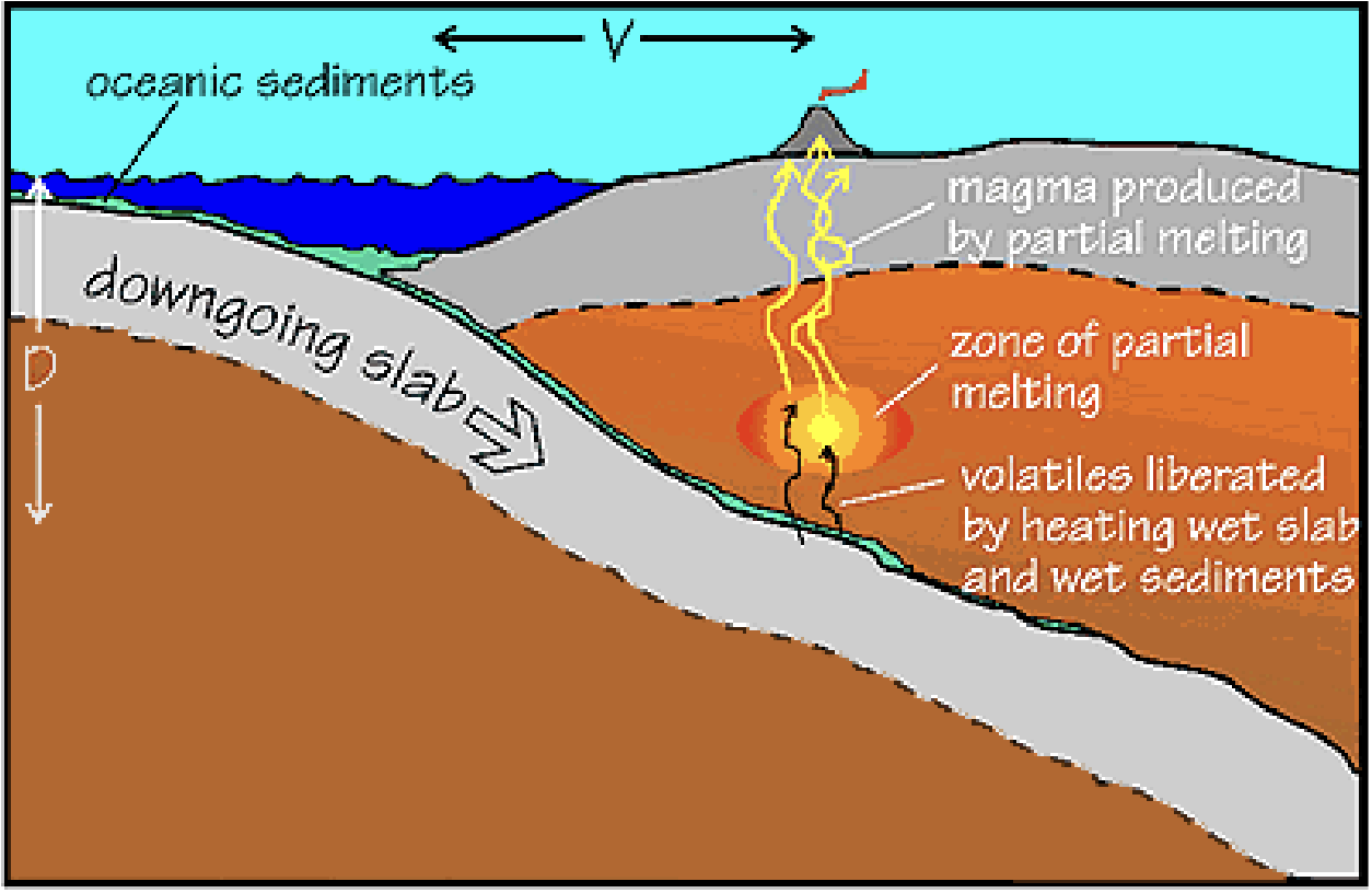
Volcanic Arcs
AKA Island arcs; Chains of volcanoes formed during oceanic-oceanic convergent boundary
Formed at subduction zones
Subduction of plate → heat/pressure make plate release water → partial melting creates magma → magma rises
Ex: Ring of Fire: Intense volcanic activity around the Pacific Ocean
Earthquakes
Release of energy in the Earth’s crust → seismic waves
Caused by shifting plate tectonics when there’s underground friction OR human activity
Fault
Fracture in the Earth’s crust where the rock on either side has moved relative to the other
Caused by tectonic movement (horizontal or vertical movement)
Faults release energy → earthquakes
Epicenter
The point directly above the hypocenter (fracture) of an earthquake
How we map earthquakes
*Distance from epicenter to hypocenter determines the earthquakes depth
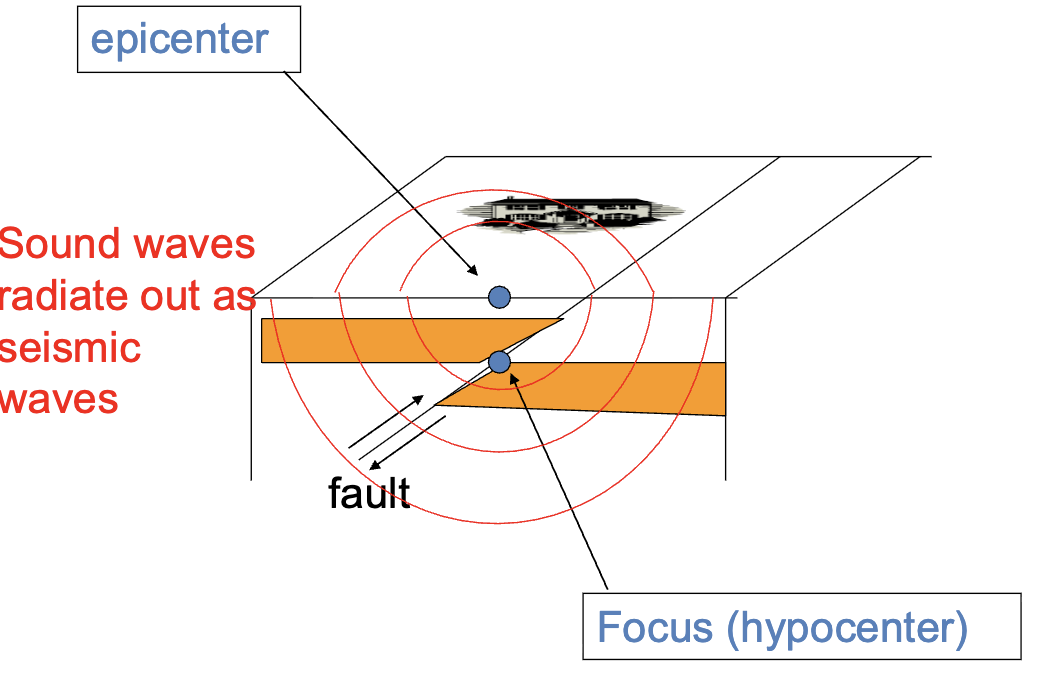
Focus
AKA Hypocenter
Exact underground location where the rock fractures during an earthquake
Releases stored energy → seismic rupture
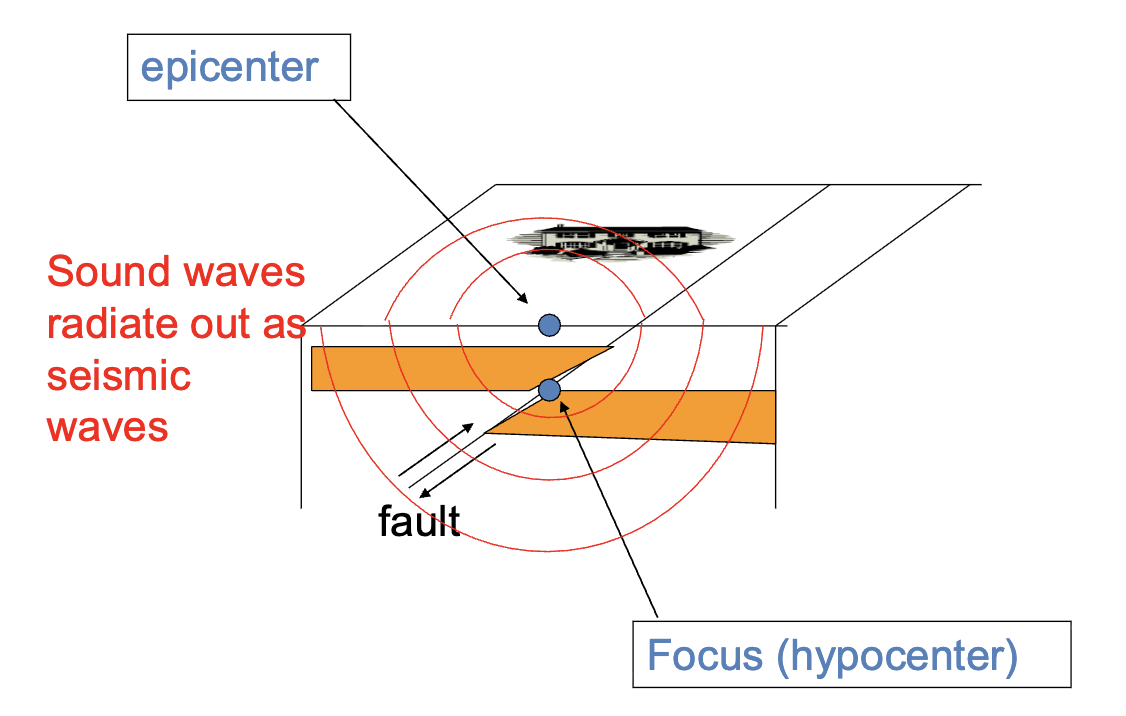
Seismic waves
Vibrations generated by earthquakes
Terms to describe a plane in 3D space
Strike
Dip
Dip direction
*How geologists define 3D orientation of tilted rock layers, faults, and fractures
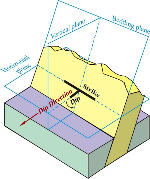
Strike
Direction of horizontal line on a planar surface, such as a rock layer or fault
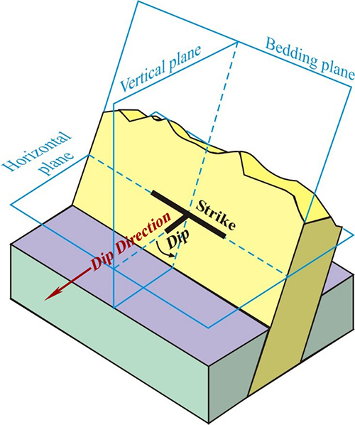
Dip
Angle of inclination of the layer, relative to horizontal
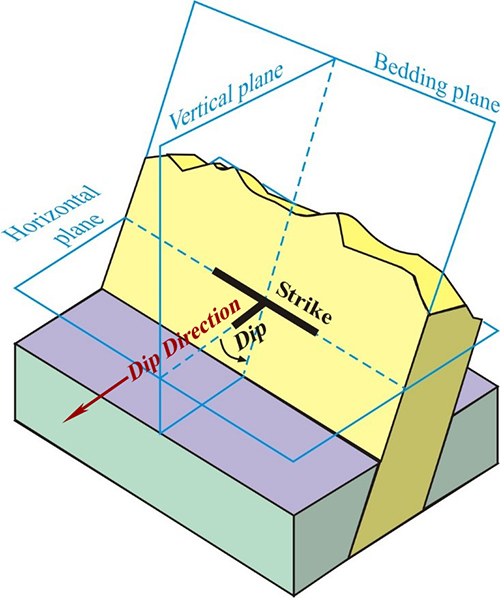
Dip direction
The down-dip direction (perpendicular to strike)
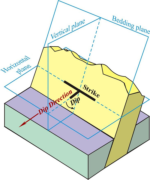
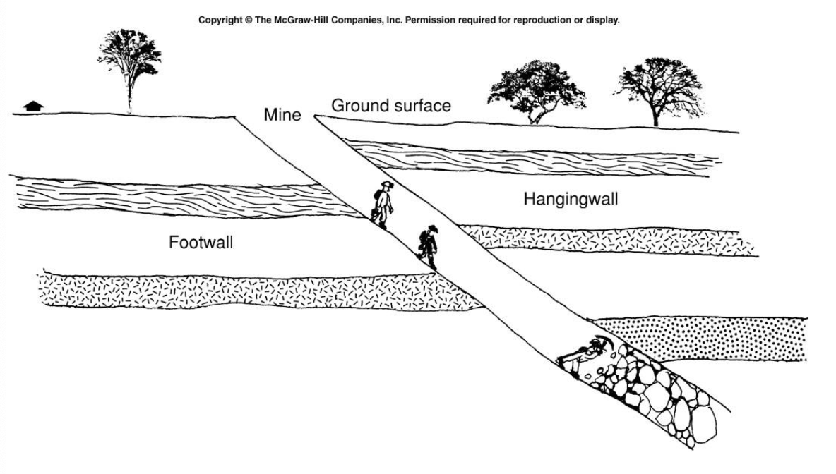
Hanging-wall
Block that sits above fault line (where you could hang a lantern)
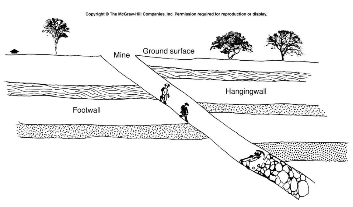
Footwall
Block that sits below the fault (where you stand)
Rested on
Types of faults
Normal Fault
Reverse fault
Strike-slip fault
Strike-slip fault, left lateral
Strike-slip fault, right lateral
Dip-slip
Fractures in the Earth’s crust where the rock blocks are vertical, moving up or down
Ex: Normal faults and reverse faults
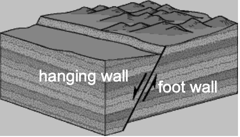
Reverse fault
Hanging-wall moves up-dip, footwall moves down-dip
Kind of dip-slip
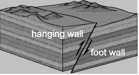
Normal fault
Hanging-wall moves down-dip, footwall moves up-dip
Strike-slip
Fractures in the Earth’s crust where the rock blocks move horizontally past each other, parallel to the fault line
Ex: Right-lateral, left-lateral
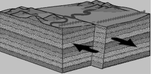
Strike-slip fault, right lateral
Far side moves parallel to strike and rightwards with respect to near side
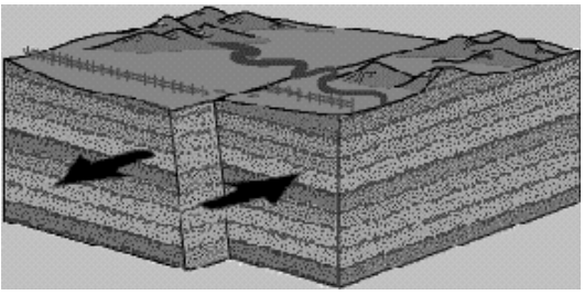
Strike-slip fault, left lateral
Far side moves parallel to strike and leftward with respect to near side
What kind of faulting do you expect from each plate boundary?
Divergent = Normal faulting
Convergent = Reverse faulting
Transform = Strike-slip faulting
Elastic rebound theory
Explains how tectonic forces create earthquakes
Stress & friction → rock along fault to bend & warp → stores elastic energy
When stress > frictional resistance → rock snaps → releasing stored energy as seismic waves
Two types of crustal deformations (earthquakes)
Stress: forces imposed on rock; the cause
Strain: change in rock’s shape in response to stress; physical deformation that happens to the rock as a result of stress (the effect)
Two kinds of earthquake strain
Elastic deformation = Happens under low stress; rock reverts to former shape when stress is removed
Plastic deformation = Rocks permanently change shape/flow; high stress conditions
Causes earthquakes
Foreshock
Smaller earthquakes that precede a larger earthquake
Smaller slips as fault begins to fail
Aftershock
Smaller earthquakes that follow it
Slips as fault continues to adjust after main shock
Offset
AKA displacement
Physical distance that the ground on either side of the fault shifted relative to one another
*How we measure the size of an earthquake
Surface rupture length
Total distance of the ground break created by an earthquake
*How we measure the size of an earthquake
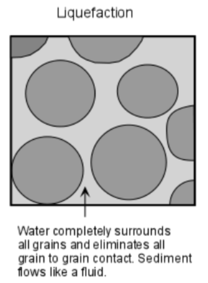
Liquefaction
Caused by an earthquake
When loosely packed soils temporarily lose their strength/stiffness → soil loses ability to support weight → behaves like liquid
Causes sandblows
Ex: 1976 Earthquake in Guatemala was triggered by intense liquefaction → destroyed homes
What can earthquakes trigger?
Sand blows
Expensive property damage
Landslides
Fire
Sandblows
When pressurized water and sand erupt into the surface
Liquefaction occurs → during earthquake, intense pressure squeezes water and sand through weak spots in the crust → erupts on surface
Caused by soil liquefaction
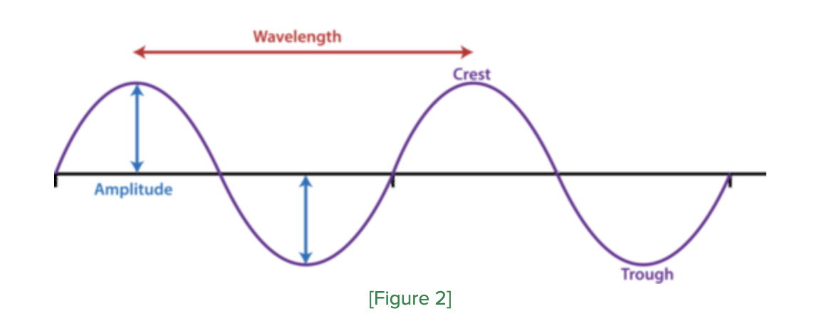
Terminology for waves
Wavelength: Distance between successive crests/troughs
Amplitude = ½ the difference in height between crests ands troughs
Velocity = Speed at which a crest/trough travels
Frequency = # of crest/troughs per unit of time
Period = Time interval between successive crests/troughs