Exam 1 GEOG 101 - Nature of Physical Geography, Nature of Planet Earth, & Minerals Rocks and Weathering
 Call Kai
 Learn
Learn Practice Test
 Spaced Repetition
 Match
Match Flashcards
 Knowt Play
1/105

There's no tags or description
Looks like no tags are added yet.
Name | Mastery | Learn | Test | Matching | Spaced | Call with Kai | Chat |
|---|
No analytics yet
Send a link to your students to track their progress
106 Terms
What is Geography?
Geography is a perspective in which you view and approach problems. Geographers ask where, when, and why when approaching issues.

What is Geographic Perspective?
a way to understand a topic or area using spatial features and relationships

What is a mental map? What are some problems with mental map
A mental map (also called a cognitive map) is your brain's internal representation of a physical space. It's the mental "map" you use to navigate, remember routes, and understand spatial relationships without looking at a physical map. Some issues include general inaccuracies associated with memories as well as bias.

What are the steps to the Scientific Method in order
Observation, question, hypothesis, experiment, analysis, conclusion

What are the differences between a hypothesis and a theory
Hypothesis: not scientifically tested or proven, based on limited data, can lead to a theory, proposed explanation for some phenomenon based on limited evidence
theory: idea or set of ideas that is intended to explain facts or events, scientifically tested or proven, based on wide range of data, can be formulated by a hypothesis

In what ways do Geographers collect spatial data
GPS, remote sensing, ground-based surveying, sonar, lidar, etc.

In what ways do Geographers analyze spatial data?
Maps --> GIS (geographic information systems)

What is remote sensing?
Remote sensing is the process of detecting and monitoring the physical characteristics of an area by measuring its reflected and emitted radiation at a distance (typically from satellite or aircraft). Special cameras collect remotely sensed images, which help researchers "sense" things about the Earth. Some examples are:
Cameras on satellites and airplanes take images of large areas on the Earth's surface, allowing us to see much more than we can see when standing on the ground.
Sonar systems on ships can be used to create images of the ocean floor without needing to travel to the bottom of the ocean.
Cameras on satellites can be used to make images of temperature changes in the oceans.
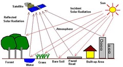
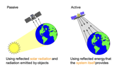
What are the differences between active and passive remote sensing
passive sensors are when the instrument just records the environment around you, like taking a picture, seismograph (measures earthquakes), or a compass. They simply respond to the world/energy around us.
active sensors produce their own energy and record the amount of energy they produce that is returned to them, like sonar, lidar, etc.
What is GIS (geographic information systems)?
Digital software for creating or presenting spatial data (maps)

What is a geographic grid?
Divides earth up into a series of circles (you see them as lines on a map)

What are the purposes of a geographic grid?
1. so you can determine your precise location
2. allows you to take the spherical earth and put it on a flat map

What is a great circle? What line of latitude is a great circle?
Great circles cut the earth in exactly half (longitude N/S)
Small circles divide earth into unequal parts (latitudes), the equator is the line of latitude that is a great circle.

What is a meridian? parallel?
Meridians are line of longitudes and converge at the polls
Parallels are lines of latitude and never converge

What are the geographic coordinates for Mankato, MN?
44.2N94W
How are coordinates for north, south, east, and western hemispheres reported?
Latitude (N/S) (0-90) then Longitude (E/W) (0-180)
Latitiudes: North of the equator is positive values (0 to 90), south is negative (0 to -90)
Longitude: West of the prime meridian negative (0 to -180), east is positive (0 to 180)
44N94W --> 44 -94

What is the purpose of a map projection?
To depict the curved Earth surface as flat

What are the three general categories for map projection?
1. Planar
2. Conical
3. Rectangular/cylindrical
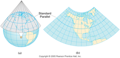
What is the name for a map that preserves size? shape? distance?
preserves shape: conformal (lambert)
preserves size: equal area
preserves distance: equidistance

What type of map projection is a Mercator map and what is a problem with the Mercator map?
equidistance, greatly distorts shape and size as you increase distance from the equator

What is geographic scale and why is it important?
a geographic scale is the level of detail that you study objects or phenomenon (like climate change [phenomenon] or trees [object])
![<p>a geographic scale is the level of detail that you study objects or phenomenon (like climate change [phenomenon] or trees [object])</p>](https://assets.knowt.com/user-attachments/580398c1-1d5a-4225-bbfe-ec139be3721a.jpg)
What are examples of geographic scale?
global scale (globe), continental scale (continent), regional scale (state or province), local scale (town, city, or county), individual (1:1)

What is map scale? How is it reported?
map scale is the ratio of distance covered on a map to the actual distance on earth
reported as a representative fraction (ex 1:600,000, "the map scale is 1 in on the map is 600,000 in on the ground"), think of it as a division

What is an example of a large-scale map? small-scale map?
large-scale map: Smaller area in more detail (MN)
small-scale map: Larger areas with less detail (globe)
What is the shape of Earth?
Oblate spheroid
Oblate = fattened
Spheroid = kinda like a shpere but not

Why does Earth have that shape?
Centripetal force from earth's rotation causes it to expand around the equator
Rotation and centripetal force and the glaciers smashing down on the poles (getting squished by the glaciers)

What is the approximate diameter of Earth?
7900 miles
For how long has it been known that Earth is round
2500
What are some simple observations that indicate Earth is round
if you are higher up in a building or mountain you will be able to see further extent of the horizon. I the earth was flat horizon wouldn't matter
Who "proved" Earth is round
Eratosthenes

How did they prove Earth is round?
using math, trigonometry, hand measured walking distance

Who is the "Father of Geography"? What did they do to earn this nickname
Eratosthenes because he proved with math it was a sphere, and invented the geographic grid

What is a systems view of Earth
an approach to study complex things by dividing them up

What are open versus closed systems?
open system is a system that energy and matter can never leave but can move
closed system, no true system on earth is closed, everything cycles. They would in theory not transfer energy or matter, the closest to a closed system on earth is an island

What are the major spheres of earth
atmosphere, cryosphere, biosphere, geosphere/lithosphere, hydrosphere

What is the environmental lapse rate
temp decreases at a constant rate as elevation increases, 3.5 degrees per thousand feet
What are the different layers of the atmosphere in order and what occurs in
each?
troposphere (weather and wind most planes), stratosphere (ozone layer and high level military planes), mesosphere (shoot stars), and thermosphere (satellite, almost outer space)
How much of Earth's surface is covered by ocean?
70-71%

What percentage of all the water on Earth is in the oceans
97.2%

What percentage of water on Earth is freshwater?
2.8%

What is the largest pool of freshwater?
Lake Superior

How does the cryosphere change throughout the year/season
Antarctic sea is starts expanding in February and retreats from October (grows in the cold season and shrinks in the warm season)(includes snow, sea ice, lake ice, glaciers, permafrost)
What percentage of Earth's land area is covered by glaciers
10%

What percentage of Earth's surface receives significant snowfal
30%

What are the different layers of Earth from the innermost to outermost
inner core solid, outer core magma, mantle, upper mantle/asthenosphere, crust/lithosphere

What is the asthenosphere
upper mantle and crust combo, mainly a very thick liquid, gives us earthquakes and volcanoes

What is the crust?
the outermost layer of rock

Where is the crust thickest
Himalayan mountains

What is the lithosphere?
the rigid outer part of the earth, consisting of the crust and upper mantle.

How is the biosphere divided?
all living organisms, divided into biomes, grassland, forest, desert, tundra, savannah, etc.
What is the name of the sphere that is the interface of all Earth's spheres except
the cryosphere?
Pedosphere, soil combo of sediment water air and organic matter

What are examples of physical cycles of Earth
water cycle (hydrologic cycle), rock cycle, and carbon cycle
How do the 1st and 2nd Laws of Thermodynamics relate to Earth
1st law - energy and matter can neither be created nor destroyed --> earth is a closed system, we cannot truly destroy matter in earth (rocks and water can change spheres and forms but cannot be created or destroyed, we have all water and rocks we will have)
2nd law - energy and matter can form uniform distribution --> earth wants to be a smooth ball (uniform and equilibrium everywhere) and is constantly working to balance out inequalities utilizing things such as wind to move warm and cold air and currents moving warm and cool water. Also, earth does not like having high places and low places, hence why mountains erode away to fill in low points, earth is trying to be even.
What is the diurnal cycle and what are some patterns/consequences of it for
Earth?
The diurnal cycle is the daily cycle (24 hours)
patters/consequences of diurnal cycle: sunrise and sunsets, temperature changes in correlation with sunrise/set, thunderstorms (correlate with sun heating air, cooling, and condensing rapidly), morning dew/frost (cooling at night), photosynthesis
What direction does Earth rotate
west to east (counterclockwise)
How fast does Earth rotate?
15 degrees per hour
How many time zones are there for Standard Time? How wide is each time zone
24 zones, 15 degrees
What is solar noon?
at the controlling meridian at line 00 when the sun is at its highest point in the sky and starts setting at 12:01, noon and solar noon are only the same thing at the solar meridian

What is a controlling meridian
every time zone that is a multiple of 15 (15 degrees wide) (lines of longitude time zones are based on)
What comes first in Mankato, noon or solar noon? why
noon will come first, then solar noon because we are at 94 degrees (4 degrees past 90 degrees [controlling meridian], so at 12:16 is our solar noon)
every 1 degree is 4 minutes; we are west of the solar meridian by 4 degrees (4 degrees west x 4 minutes per degree= 16) hence 12:16
temporal cycle
seasonal/annual cycle
What is the aphelion? perihelion? In what season does each occur
aphelion is when earth is furthest from the sun (during our summer early July)
perihelion is when earth is closest to the sun (during our winter early January)
What is the tilt of Earth's axis
23.5 degrees, coincides with the tropics (the tropic of cancer and the tropic of Capricorn)
What causes the seasons
earths revolution around the sun on a tilted axis
What is an equinox and when do they occur
Where the sun is directly over the equator, equal day (12 hrs) and equal night (earth is tilted neither towards nor away from the sun), occurs on March 20ths/21st and September 21st/22nd, half of the earth is in darkness (12 hr night) half the earth is in lightness (12 hr day)
What is a solstice and when do they occur?
The summer solstice is when the northern hemisphere is at its strongest tilt toward the sun (longest day June 21st/22nd).
The winter solstice is when the northern hemisphere is at its strongest tilt away from the sun (shortest day December 21st/22nd).
What are the tropics and why are they at that latitude
tropics are at 23.5 degrees due to/correlate with the tilt of the earths access
tropics of cancer (summer solstice sun is directly overhead) and tropics of Capricorn (winter solstice sun is directly overhead)
What is the Arctic/Antarctic Circle and why are they at that latitude?
points of earth at 66.5 degrees N and S (90 - 23.5 = 66.5), controlled by the tilt of the axis, where for 1 day a year the sun never sets, and one day a year the sun never rises
Where is the Prime Meridian? International Date Line? What are they?
the prime meridian is fixed at 0 degrees longitude
the international date line generally follows the 180-degree meridian (halfway around the world) (longitude E/W), traveling to the eastward you go back a day once crossing teh international date line, travel westward you move forward a day once you cross the international date line
What is an element? compound?
An element is a chemical substance that cannot be broken down any further
A compound is a combination of two or more elements

What are the five most common elements on Earth in order by percentage
Oxygen
Silicon
Aluminum
Iron
Calcium
What is a mineral?
a naturally occurring, inorganic solid that has a specific internal structure and a specific chemical composition (composed of elements and compounds)

What is an example of a soft mineral? hard mineral
Soft mineral: Graphite
Hard mineral: Diamond

What are the three primary rock types?
igneous, sedimentary, metamorphic

What is the most common rock type on Earth? on Earth's surface
Most common rock type on earth: igneous
Most common on earth's surface: Sedimentary

What are the different types of igneous rocks (with examples of each)
Intrusive: Gabbro, diorite, Granodiorite, and granite
Extrusive: Basalt, Andesite, Dacite, Rhyolite
How can you distinguish the different types of igneous rocks
Whether the rock was made out of lava (magma above earth's surface, extrusive) or whether it was made out of magma (lava that's below ground, intrusive)
What is the difference between magma and lava
Magma is molten rock located below the surface; lava is molten rock erupted above ground.

What is a pluton?
An extensive igneous rock (extensive, like a hill)

what is a batholith?
A huge pluton (miles)
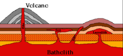
what is a laccolith?
Like a batholith, but it has to have a dome shape (bedrock hills)

what is a sill?
a skinny wide rock body (like a windowsill)

what is a dike/dyke?
A narrow tall rock body (like a wall)

What are the different types of sedimentary rocks
clastic, chemically precipitated, biological/organic

What is lithification?
the process by which sediment is accumulated, compacted, and cemented into rock due to pressure.

Where do most sedimentary rocks form?
In the ocean or marine settings (lakes and water bodies)

What are clasts? What is the most common clast?
clasts are rocks that are weathered into little pieces of rock and then accumulated and cemented together to create a bigger rock, the most common clast is sandstone

What are the different types of clastic sedimentary rocks? how are they
subdivided?
Sand, silt, shale, breccia (formed during volcanic eruptions, angular), and conglomerate (associated with water, round rocks cemented together in water)
Subdivided by size (sand, silt shale) and shape (breccia - angular, conglomerate - rounded)
What is a precipitate? evaporite? What are examples of each?
Chemically precipitated is where water dissolves a solid substance, it turns into a liquid, and then turns back into a solid (ex: Kool-Aid, you take water + sugar (solid) + stirring = Kool-Aid --> rivers mimic stirring)
Evaporite is when water evaporates and leaves behind the minerals that were dissolved within it (ex: salt from sweat, sweat evaporates but the salt is left over in white flakes)
How do biological sedimentary rocks form? What are examples
Biological are made of the remains of once living (organic matter), plants/animals die, they accumulate, compact, and cement into rock
Examples: Chalk limestone, coquina limestone, fossiliferous limestone, peat (not rock, future coal), lignite coal, anthracite coal
Where do metamorphic rocks form
Deep beneath the Earth's surface, when you take one rock and turn it into a different rock due to contact and compression (high/intense heat or pressure) (in volcanoes or at plate tectonics)
what is a metamorphic rock
igneous or sedimentary rock that gets metamorphosed into a different type of rock under intense heat or pressure (in volcanoes or at plate tectonics), making the rock very hard and dense
How are metamorphic rocks subdivided
Foliated (have bands/layers) and non-foliated (no bands/layers)
What are examples of metamorphic rocks and their original rock
Limestone + high heat/pressure --> marble
Shale + high heat/pressure --> slate
Diorite + high heat/pressure --> gneiss
What is the rock cycle?
Forces deep inside Earth and at the surface produce a slow cycle that builds, destroys, and changes the rocks in the crust. Doesn't matter where you start.
Ex: Volcano erupts, lava spews out and hardens into igneous rock, that rock is worn down into sediment, that sediment is carried into the ocean where is it accumulated, cemented, and lithified into sedimentary rock, that sedimentary rock is located near a fault where is undergoes high pressure at the subduction zones and turns into metamorphic rock, as that metamorphic rock goes deeper into earth's surface due to the subduction of the plates, it eventually spews up through a volcano and becomes an igneous rock and the cycle begins again

What is weathering, where does it occur, why is it important
The physical or chemical breakdown of particles (like rocks), occurs everywhere on earth, important because weathering creates new minerals important for soils (and we need soils for everything, food, resources, etc.)
What are the long-term effects of weathering
soil formation, erosion, denudation
What is denudation?
The wearing a way of landscapes through weathering and erosion
How can you tell a landscape is denuded
Rounded eroded hills covered in soils and vegetation
What is physical weathering? chemical weathering?
Physical also known as mechanical weathering, physical weathering involves the breakdown of rocks and minerals into smaller pieces without changing their chemical composition.
Chemical weathering involves the chemical alteration of minerals within rocks, forming new minerals and soluble salts. This type of weathering contributes to soil formation.