APHUG Unit 6
1/97
Earn XP
Description and Tags
terms marked * are not vocab terms
Name | Mastery | Learn | Test | Matching | Spaced | Call with Kai |
|---|
No analytics yet
Send a link to your students to track their progress
98 Terms
city
large, densely populated settlement w/ more residents than rural areas
urban
relating to city
agricultural surplus
crop yields more than enough to feed family
socioeconomic stratification
categorizing ppl into groups based on factors like wealth, job, power, race, that control goods & ppl
e.g. gov’t
first urban revolution
agricultural & socioeconomic innovations that led to rise of earliest cities
urban hearth areas
regions where world’s first cities evolved
e.g. Mesopotamia
site
absolute location of a place on Earth
situation
relative location of a place in terms of its surrounding features
capitalism
economic & political system where trade and industry = controlled by private owners for profit
communism
economic & political system where property = publicly owned
streetcar suburbs
settlement outside city w/ streetcar lines; streetcars take residents in & out city easily
second urban revolution
industrial innovations in mining & manufacturing led to increased urban growth
redevelopment
set of activities & gov’t policies intended to revitalize area that has fallen on hard times
metropolis
very large & densely populated city, esp capital of region or country
e.g. Mexico City
urban area
U.S. self-governing place w/ at least 2,500 ppl
urbanized area
U.S. urban area w/ at least 50,000 ppl
urban cluster
U.S. urban area fewer than 50,000 ppl
metropolitan statistical area (MSA)
U.S. region w/ at least one urbanized area as its core
micropolitan statistical area
U.S. region w/ at least one urban cluster of at least 10,000 ppl but fewer than 50,000 ppl at its core
suburb
populated area on outskirts of city
urbanization rate
percent of nation’s population living in towns & cities
suburbanization
movement of ppl from urban core areas to suburbs
sprawl
pattern of cities to grow outward in unchecked manner
automobile cities
size & shape are controlled by and often require industrial automobile ownership
e.g. Los Angeles, Denver, Phoenix
decentralize
to move business operations from core city areas into suburbs
edge city
concentration of business, shopping & entertainment developed in suburbs
e.g. Tysons or Tysons Corner, VA
boomburbs/boomburgs
places w/ more than 100,000 residents that’s not core city in a metropolitan - large suburb w/ its own gov’t
e.g. Mesa, AZ
infill development
building of new retail, business or residential spaces on available land plots in already developed areas
exurb
semi-rural district located beyond suburbs, often inhabited by well-off families
world city
world center of trade, finance, info & migration; control centers (nodes) of global economy
e.g. Paris, LA, NY, HK
gated communities
privately governed & highly secure residential areas in city, often has fence or gate outside
urban system
set of interdependent cities or urban places connected by networks
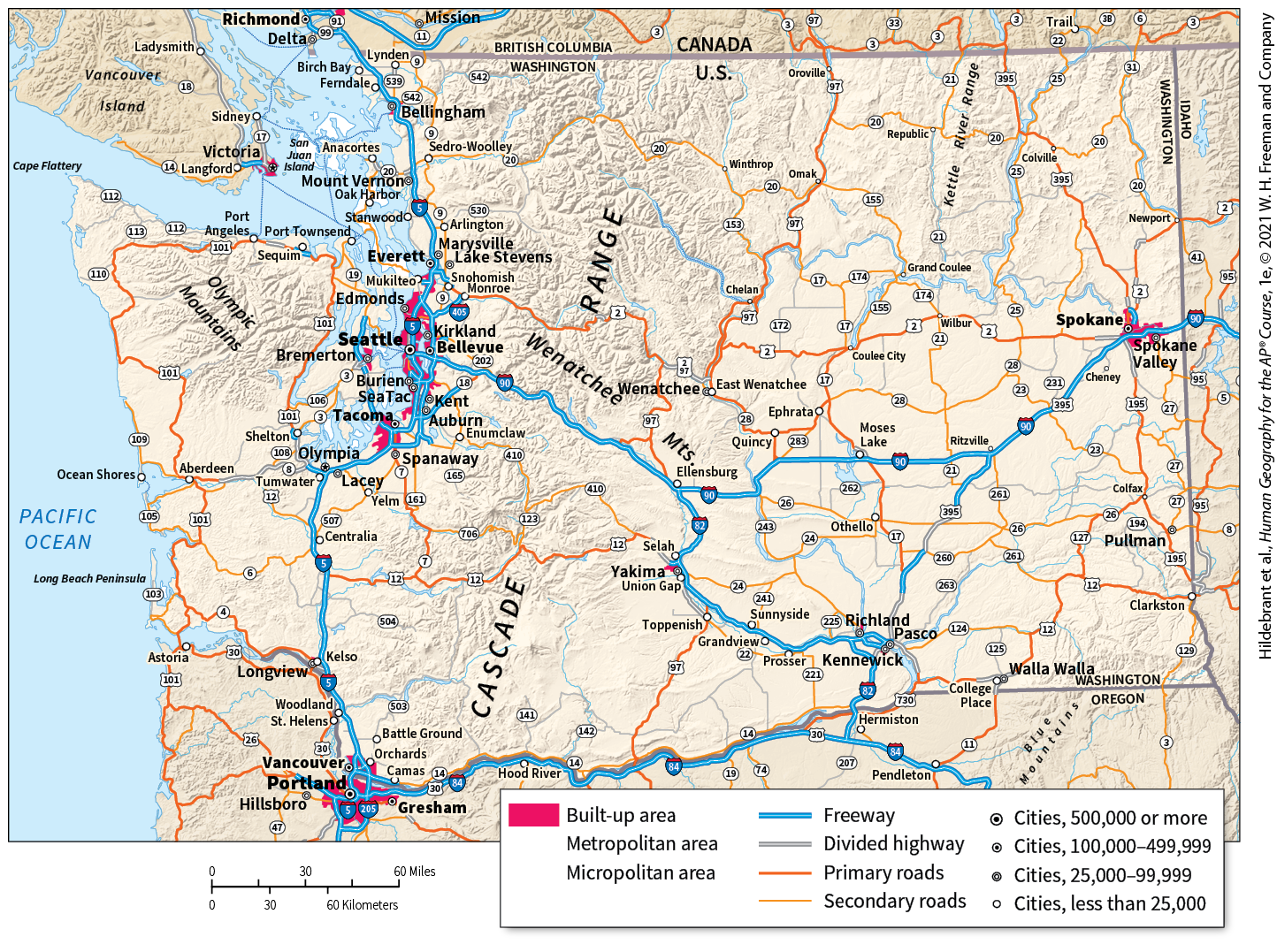
urban system of Washington*
cities btwn major cities linked by highways, ports & communication systems
rank-size rule
population of settlement = inversely proportional to its rank in urban hierarchy
i.e. city #1: x ppl, city #2: x/2 ppl, city #3: x/3 ppl
urban hierarchy
ranking of cities - most powerful & largest cities at top
primate city
city much larger than any other city in country & dominates country’s economic, political & cultural life
e.g. Lagos, Athens, London, Moscow
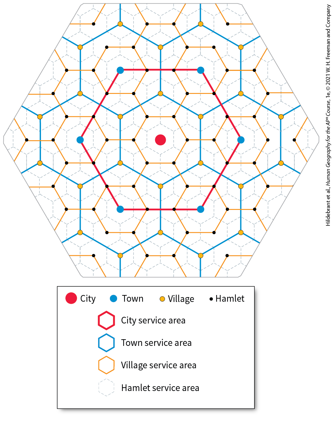
central place theory
model attempting to understand why cities located where they are
central places
settlements that make certain types of products & services available to consumers

central place theory assumptions*
1. surface of region = flat w/ no physical barriers (e.g. mountains)
2. soil quality uniform everywhere
3. population & purchasing power evenly distributed
4. region has uniform transport networks
5. at any given place, any good can be sold in all directions to certain distance
threshold
# of ppl required to support businesses
range
distance ppl will travel to acquire a good
gravity model
mathematical model attempting to predict how places will interact
equation: p1 x p2 divided by distance squared
closer 2 places are, more they will influence each other
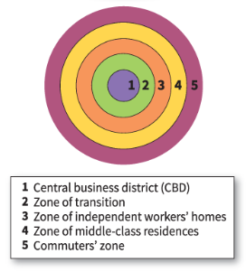
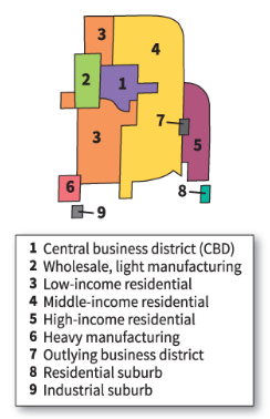
concentric zone model
model of city’s internal organization developed by E.W. Burgess showing rings of factory production & different residential zones expanding outwards from CBD
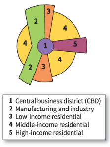
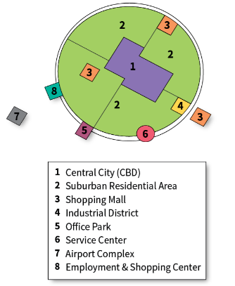
Hoyt sector model
model of city’s internal organization developed by Homer Hoyt w/ transportation & communication both determining city’s layout
e.g. Chicago
multiple-nuclei model
model of city’s internal organization developed by Chauncy Harris & Edward Ullman showing residential districts organized around several nodes (nuclei)
galactic city (peripheral) model
model of city’s internal organization where CBD remains central but scattered business & residential areas = linked by ring road or beltway
e.g. Detroit
bid-rent theory*
assumes accessibility & usefulness decreases as distance from CBD increases
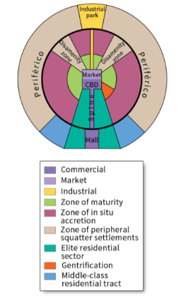
Griffin-Ford model
model of internal structure of LatAm city developed by Ernst Griffin & Larry Ford, combines concentric zones & radial sectors
gentrification
displacement of lower-income residents by higher-income residents as area improves
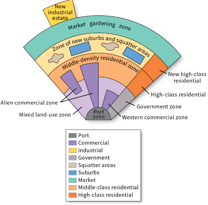
Southeast Asian city model
model of medium size port city in SEA developed by T.G. McGee, shows old colonial port as focal point w/ surrounding alien & Western commercial zones
large middle-class PUSH out ppl from focal point

sub-Saharan city model
shows cities w/ 3 CBDs to reflect colonial, traditional, marketing influences
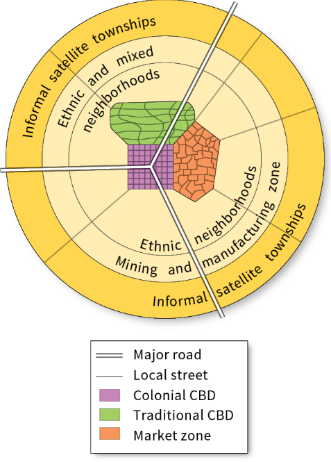
sub-Saharan city model’s CBDs*
- colonial: informal market, transitional business center
- traditional: traditional one-story buildings
- marketing: informal, essential to residents
commonality btwn non-North American city models*
all have expanding outer squatter settlements
perceived density
general impression of estimated # of ppl present in a given area
zoning regulations
laws dictating how land can be used
fiscal squeeze
occurs when city revenue cannot keep up w/ increasing demand for city services & costs on decaying infrastructure
built environment
human-made space where ppl live, work & engage in leisure activities on daily basis
smart growth
policies that combat regional sprawl by addressing problems of population density & transportation
focus of smart growth*
environmental protection & compact, walkable neighborhoods near public transportation
compact design
development that grows up rather than out
diverse housing options
policy encouraging building quality housing for ppl of various backgrounds in a range of prices
new urbanism
approach to city planning on fostering European-style cities of dense settlements w/ diverse housing, walkability, & attractive architecture
greenbelt
zone of grassy, forested or agricultural land separating urban areas - promote healthy lifestyles & ecological health
slow-growth cities
cities that change its zoning laws to decrease rate the city spreads horizontally w/ goal of avoiding sprawl’s negative effects
zoning
classification of land according to restrictions on use & development - chief planning tool of local gov’ts
anti-displacement tenant activists
advocates for poor & working-class residents at risk of losing affordable housing bc of new development
de facto segregation
racial segregation not supported by law but still apparent
mortgage
loan taken out to purchase a home
redlining
practice of identifying high-risk neighborhoods on city map & refusing to lend out mortgages to those interested in buying property
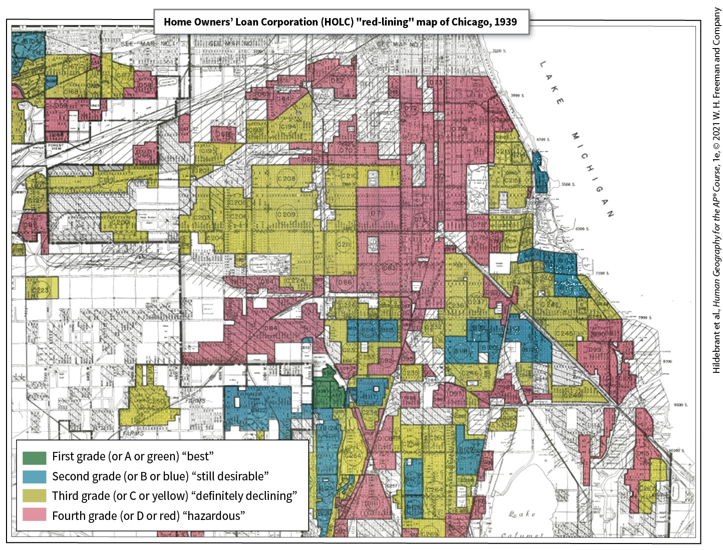
1939 Federal Housing Administration map of Chicago*
illustrates redlining
blockbusting
practice where realtors persuade homeowners to sell their homes bc neighborhood is declining from black families moving in
white flight
mass movement of white ppl from city to suburbs
affordability
maximum price a buyer can afford to pay for housing
housing choice voucher program
federal gov’t program to assist very-low-income families, elderly & disabled w/ affordable & satisfactory housing
violent crime
category of crime including murder, rape, robbery, & aggravated assault
social controls
formal/informal institutions that help maintain law & order
e.g. police
hotspots*
micro areas w/ higher incidence of violent crime
e.g. vacant lots
environmental injustice*
certain groups, usually poor or immigrants, carry more environmental risks than wealthy
environmental racism
occurs when areas inhabited by low-income POC are targeted for environmental contamination
environmental justice
movement to fix environmental discrimination
squatter settlements/favelas/shantytowns
areas of degraded, seemingly temporary, inadequate & often illegal housing
land tenure
right to own or hold property - defines ways how rights to that property are managed
inclusionary zoning (IZ)
laws requiring part of new construction to be affordable for low to moderate-income ppl
exclusionary zoning
attempts to keep low to moderate-income ppl out of neighborhood
NIMBYs
tries to prevent construction of affordable housing & other types of development
below market rate housing
costs much less than the going/market rate
urban renewal
large-scale redevelopment of built environment in downtown & older inner-city neighborhoods
fiscal imbalance
occurs when gov’t must spend more than it receives in taxes
fiscal zoning
practice of regulating local land use to preserve & possibly enhance local property tax base
ecological footprint
total amount of natural resources used & their impact on natural environment
urban heat island
mass of warm air that sits over a city, generated by urban building materials & human activities
urban footprint
spatial extent of urban area’s impacts on natural environment
urban risk divide
idea that disasters & disaster risk become urban phenomena as world population becomes increasingly concentrated in large cities
disasters become more destructive in cities bc so many ppl live in them
brownfields
properties whose use or development may be complicated by potential presence of hazardous substances
brownfield remediation
process of removing or sealing off contaminants so a site can be used again w/o any health concerns
phytoremediation
removal of contaminants w/ plants that react, degrade, or draw up contaminants from soil into shoots & leaves
Farmland Protection Policy Act (FPPA)
U.S. law granting municipalities oversight over federally funded development projects on farmland
scattering developments
subdivisions or developments that do not border on existing settlements but remove agricultural land from production