11) The Holderness Coastline
1/31
Earn XP
Name | Mastery | Learn | Test | Matching | Spaced |
|---|
No study sessions yet.
32 Terms
Holderness Coast
located on the east coast of England
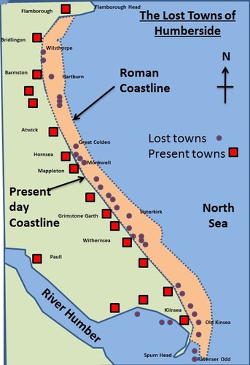
highest rates of coastal erosion in the UK of 2m/year
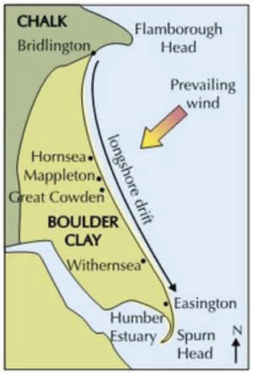
61km long from Flamborough Head in the north to Spurn Point in the south
Factors contributing to high rates of erosion
1. Geology
= cliffs made of boulder clay, absorbs a lot of water and very low resistance
2. Wave energy
= strong, shallow currents, destruction of waves from north sea
3. Movement of sediment
= sediment is rapidly removed from area
Cliff rock type
boulder clay
- known as a drift deposit or glacial till
- a thick blanket of rock that was eroded by an ice sheet and ground up into clay during the ice age
- dragged and eventually deposited as ice sheets melted away
... repositioned the coastline by filling in a previous chalk bay with glacial deposits
Physical processes at work
1. Erosion
... hydraulic action, attrition, corrasion
2. Mass Movement
... rotational slumping (weakening of cliffs due to water lubricating material so that it slumps), mudflows
3. Transport Processes
... longshore drift, suspension
4. Weathering Processes
... freeze thaw, salt crystallisation
sediment cell
Located on sediment cell 2a
- flamborough head to sunk island (saltmarsh)
- Holderness is eroded and the materials are deposited further south in sediment cells 2c and 2d
o Small quantities of sand transported north by tide cycle, with storms contributing to erosion
o Wave and tidal forces lead to erosion of clay cliffs
o Material is then eroded southwards by wave action (mud + clay in suspension)
o Sediment moves offshore or continues to build up beaches further south
= 3 million m^3 of clay eroded from area per year
Integrated Coastal Zone Management (ICZM)
looks at effects of defences within the sediment cell with sustainable defences in key locations, minimising negative impacts elsewhere
- Hold the line
- Managed retreat
- Advance the line
- Do nothing
Hold the line
= when coastal defences are built or maintained to protect the current
uses soft and hard engineering
Managed retreat
= deliberate coastal flooding of low-lying land and creation of wetlands on low value land
Advance the line
= extend the coast into what is naturally the sea
Do nothing
no active intervention
Flamborough Head to Gibraltar Point
= part of sediment cell 2, SMP 3
Only 2 methods of ICZM:
o Hold the line
o Do nothing
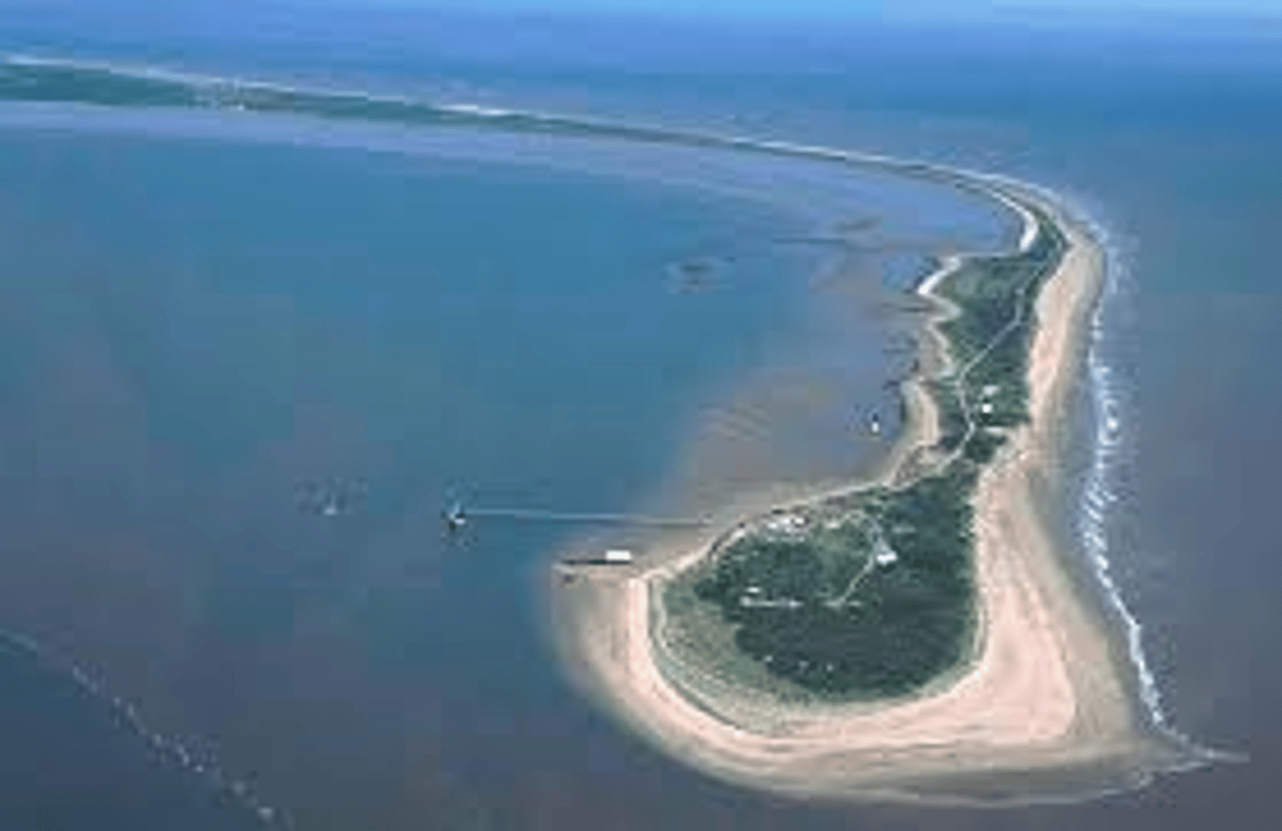
Spurn Point
= a peninsular spit, site of special scientific interest which attracts tourists from all around the world and protects estuary from erosion
145 acres in 1945, now only just over half that size
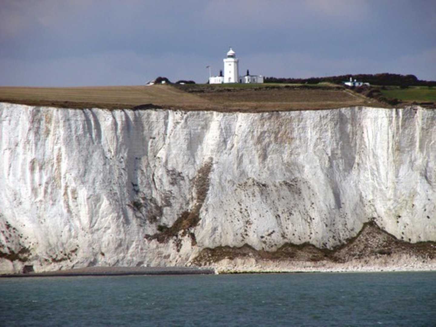
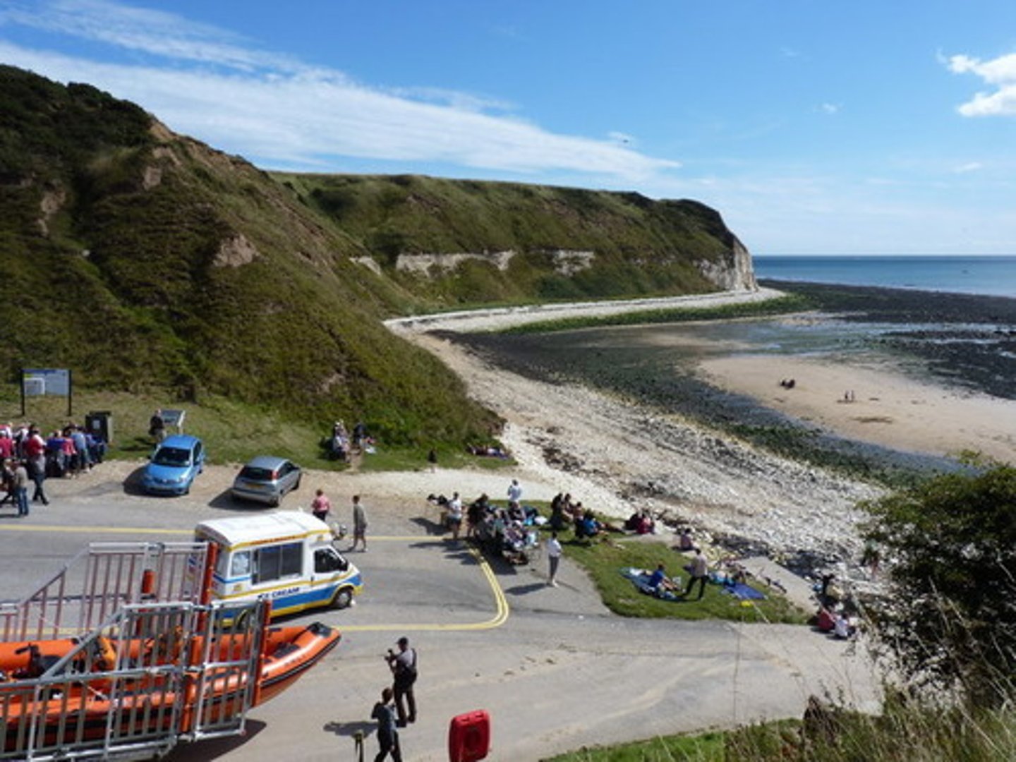
Flamborough Head
= important site of ecological value, habitats for birds, site of special scientific interest
- Chalk geology is more resistant than clay elsewhere, so stacks, caves, arches, and wave cut notch are formed via hydraulic action and abrasion
- When the cliff retreats, leaves an offshore platform from eroded material
... Prevailing winds from the north east transport any deposited material southwards by longshore drift
... Visitors put pressure on the landscape, removes vegetation and exposes it to wind and rain, causing more erosion
Defending the Coast
... local authorities have to decide which area stop protect and which to allow to erode
= Bridlington, Hornsea, Withernsea in Holderness are protected
- Timber groynes
... trap sand to prevent longshore drift, installed originally 150 years ago
- Resistant boulders
... to absorb wave energy, sea walls
Mapleton
= 3 miles south of Hornsea, situated on road that connects towns along the coast (34m from sea)
... coast of huge economic importance to the area as it provides access to a range of towns and villages for locals
... population of only 249, has experienced full force of coastal erosion with 75m of land disappearing
o Popular tourist destination for holidaymakers
o Widely used by local farmers for access to rich agricultural land
o Community needing protection + prevention of longshore drift
o 1/3rd of all UK natural gas from North Sea comes from Dimlington and Easington Gas Terminals
Mapleton Defences
1990, under threat from losing 30 houses + main road
1991 sea defences built in order to protect area, £1.9 million project
- 2 large rock groynes to absorb wavelength
- large granite boulder revetments (450m), expensive but long-lasting
RIP RAP PARALLEL TO COASTLINE - ROCK FROM NORWAY, COST AROUND 2 MILLION POUNDS
- vegetation planted to stabilse cliffs from mass movement
Strengths Mapleton Defences
= effective, reduced slope of cliffs, road remains intact, no properties lost, erosion slowed to point where it is no longer a threat to settlements
- Businesses have the confidence to invest and develop companies within the area, benefiting the local economy (e.g., 20 people employed at a garage which has been there since the 90's)
- Increases the size of the beach which attracts tourists, residents, and fishermen
- 25% of nations gas comes through Easington, new defences should protect gas supplies for next 50 years
Weakness Mapleton Defences
arguments against coastal management of some areas due to affects it will have elsewhere
= suggested "do nothing" approach" to protect other areas
- Deprivation and starved beaches south of defences as much of eroded material is transported to the river bed of the river Humber which helps decrease flooding further inland due to drainage of river basins
... without them community's further inland would flood
Around £200,000to maintain defences a year + every year the coastline becomes harder to defend
Sustainable management
Kiln Sea = most southernly village on Holderness coast
... There are no sea defences here as it is a small community of 80-90 people and the council believe it's not worth it as the costs outweigh benefits
- Areas are very low lying so susceptible to flooding from the Humber estuary and the sea itself
- Flood banks are protected by large rocks on the riverbank and maintained by EA
But...
- No hard engineering or effective defences on the coast line
- Soft engineering flood banks which are only expected to last another 20-30 years
... Houses have a finite life + people have to manage expectations as they may have to relocate due to retreating cliffs
Sandy beach caravan park
Located on an old army base called fort William which had groynes but without maintenance they disappeared, leaving beach vulnerable to erosion
- losing land = losing areas available to be used for business loss of money
... Roll back scheme introduced to give favourable planning consideration to park owners if they wanted to retreat back to agricultural land and allowed them to build 5 new caravan bases for every 4 they lose
Problems...
= Any defences at kiln sea would affect spurn point
... Would alter shipping channels + lanes, only launch and control lifeguard station located here, and it holds great economic importance
- plans to hold the spit in place to allow material to be deposited in the Humber estuary for improved drainage and sea defences would cause changes to the spit
- Any changes to the estuary may cause flooding inland, alter ports further south and disrupt shipping
Holderness coastal defences
· Revetments (Easington)
· Rock amour (Easington)
· Reinforced concrete walls (South Withernsea)
· Offshore structures (South Withernsea)
· Beach nourishment (Withernsea)
· Splash walls (Hornsea splash wall)
· Groynes (Hornsea)
· Seawalls (Hornsea)
· Sand dunes (Spurn Peninsula)
· Flood blanks (Kiln Sea flood-banks)
Withernsea
= seaside resort town 10 miles north of Spurn Point
... town is surrounded by rich agricultural land and yet sits close to the cliffs and North Sea
o Lies upon boulder clay deposited by glaciers during the last ice age 18,000 years ago
(Boulder clay is very soft and erodes easily)
o Groynes, concrete seawalls, rock amour
... defences caused increased erosion south of Withernsea as groynes starve beaches south from deposited material and energy is focused onto cliffs
= local sediment budget is affected as sections of cliffs become unstable and collapse
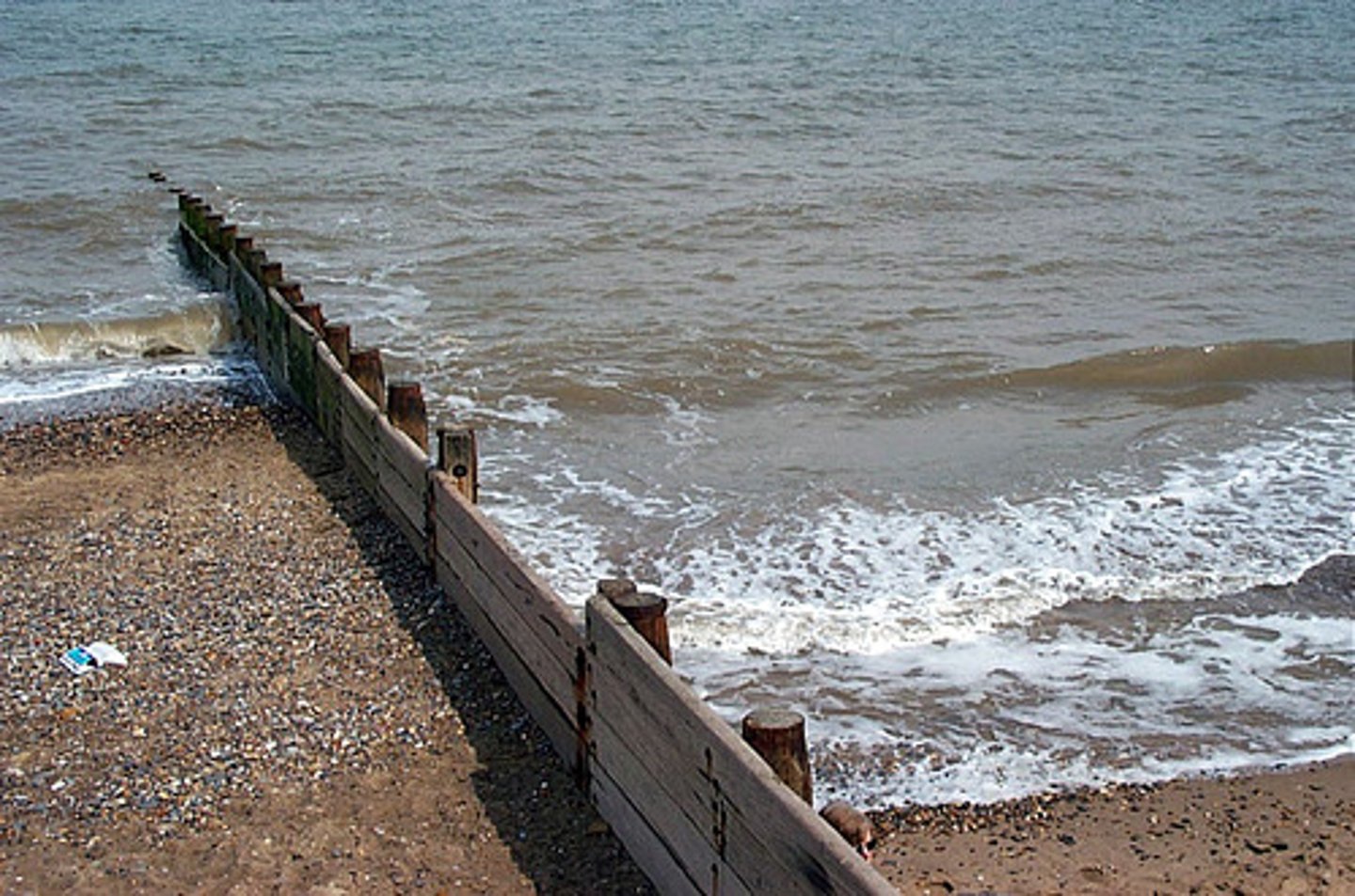
Withernsea - groynes
= help to retain sand adjacent to hard coastal defences
= originally installed in early 20th century, replaced/refurbished in 2017
Have a lifespan of 50 years
Withernsea - sea wall
= recurved seawall along promenade
Present seawall cost = £6.3 million
£5000 per metre
Withernsea - rock armour
= absorb wave energy to reduce impact on seawall and cliffs behind
Lie in front of seawall
Expensive but long-lasting (from Scandinavia)
Clinometer
= measure gradient of beach + angle of each slope
... measures how much sediment the groynes are trapping, the steeper the beach the more material trapped
= effective, beaches north of the groyne have a larger angle than the beaches south of the groyne
... material no longer being transported south via longshore drift
Wave energy data Hornsea
Mean waves from 00:00-12:00 = 9.004 waves per minute
Mean waves from 13:30-1:30 = 15.176 waves per minute
Constructive waves = 6-8 waves per minute
Destructive waves = 13-15 waves per minute
= high energy wave environment
Effectiveness of holding the line
= Erosion rates increase as you go down the coastline due to increased exposure
Further north is protected slightly by Flamborough Head
The stable bays concept theorises that the coast will protect itself over a long period of time
- Energy is focused at artificial defences
- Energy therefore disperses at bays and headlands so that less erosion occurs
... theory does not consider rising sea level or the refraction of the waves meaning that the waves attack the coast from behind the defences
...entirety of area could be underwater, or islands could be formed due to waves attacking behind the hard defences (e.g., groynes)
Challenges in terms of coastal processes
· Increased wave power and erosion
= rates of hydraulic action, abrasion, longshore drift, and transport into offshore zone
studies show an increase in mean wave height in the North Atlantic of 2% a year since 1950
· Analysis of maximum wave heights in the North Sea over 1955 to 1999 strongly indicate increasing extreme wave heights of 0.74cm per year
Increased temperature increases kinetic energy, so there is Increased movement of gases from high to low areas transfers more energy to the seas, increases wave heights and strength of waves
· Increased rates of rotational slumping and cliff collapse at Aldborough
From 1852 - 1951 rates were at 1.16m/
· Eustatic sea level rise
... 3.0mm/year against low lying land and increasing storm surges through estuary
... land at Holderness is sinking at a rate of 1.0mm/year due to isostatic rebound
· IPCC reports total sea level rise of 50cm along Holderness coastline during 21st century
· Coastal plain most likely to be submerged from the south via River Humber estuary and the river Hull floodplain
Challenges in terms of place
· Hold the line @ Mappleton (population ~200)
... long term protection of road from rock armour, groynes, cliff regrading + cliff drainage creates terminal groyne syndrome further south
· Hold the line @ Withernsea (population ~ 6,000)
... long term investment in defences as they need constant maintenance
(Recurved concrete sea wall, rock armour, groynes)
· Hold the line @ Easington Gas Terminal
... 40-year gas supply needs a long-term defence
Current cliff regrading, rock armour and groynes will not effectively manage
· Do nothing @ Kilnsea (population ~80)
... given 20-year lifespan and soft engineering strategies are left to deal with storm surges
Challenges in terms of feedback systems
· Positive feedback in the form of rapid erosion followed by constant sediment removal from longshore drift
· Positive feedback to do with the role of climate change in increasing wave height and energy + Eustatic sea level rise
· Negative feedback in the form of human intervention to hold the line approach at key locations as trying to stabilise coastal retreat
· Stable bays concept = artificially create negative feedback by focusing wave energy on resistant coastal defences and dispersing wave energy across a series of shallow bays --> slows down coastal retreat
Dr Hugh Ellis
"Hull could be wiped off the map in 100 years if sea levels continue to rise at current rate"
"sea levels could be at least a metre higher by 2100"