apes u4
1/38
There's no tags or description
Looks like no tags are added yet.
Name | Mastery | Learn | Test | Matching | Spaced |
|---|
No study sessions yet.
39 Terms
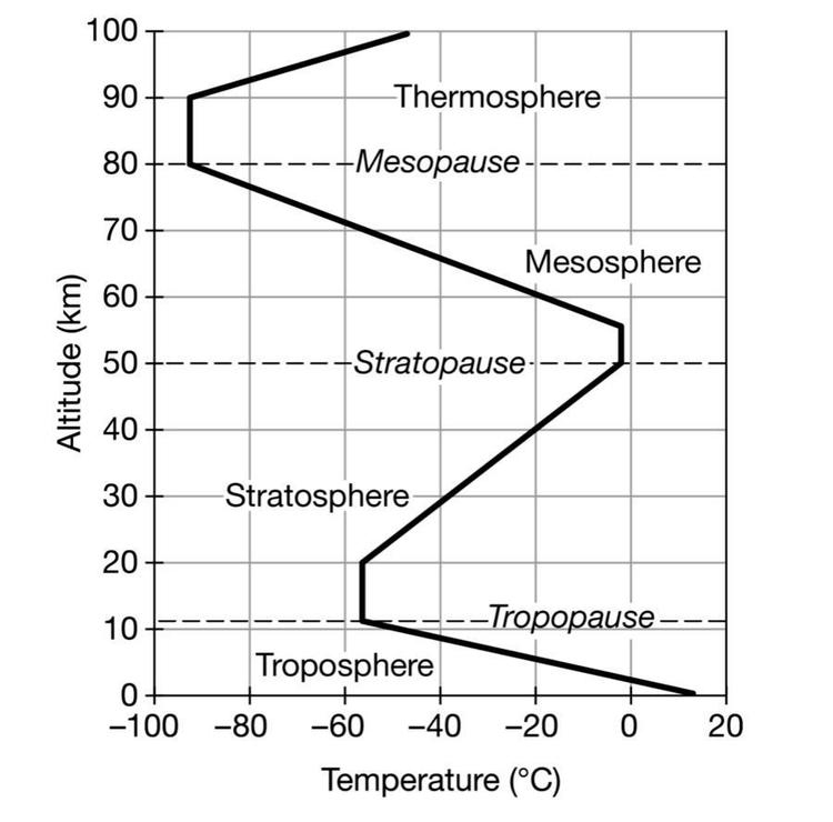
The graph shows the altitude and temperature for different layers of Earth’s atmosphere. Based on the diagram, which of the following identifies a characteristic of the atmosphere between the stratopause and the tropopause?
Cloud formation occurs in the stratosphere.
The warmest air is found in the mesosphere.
The ozone layer is in the stratosphere.
The troposphere is the closest layer to the sun.
The ozone layer is in the stratosphere.
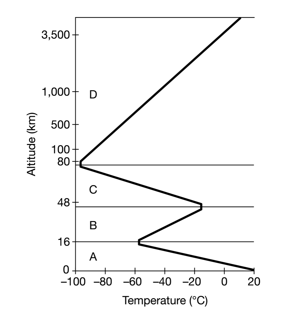
Which of the following correctly characterizes one of Earth’s atmospheric layers?
Layer A is the stratosphere, where meteors are found.
Layer B is the troposphere, where weather occurs.
Layer C is the stratosphere, where the ozone layer is found.
Layer D is the thermosphere, where auroras are found.
Layer D is the thermosphere, where auroras are found.
Based on the data in the diagrams, in which layer of the atmosphere would short wave radio signals be reflected?
exosphere
Based on the diagram, which of the following changes are most likely to occur in the central and eastern tropical Pacific during El Niño?
The Peruvian current weakens, leading to warmer-than-average sea-surface temperatures
The low anchovy catch in 1998 was most likely the result of
reduced ocean upwelling along the coast
The high sea surface temperature in 1998 was most likely due to ___. What causes air to rise
El Nino
warm air rises
El Niño, a periodic warming of ocean surface waters, occurs in which of the following regions?
Tropic East Pacific
What would 50% sand, 25% silt, 25% clay be
Sandy clay loam
Which of the following is the correct order of soil particles in order of increasing size?
sand, silt, clay
30 degrees S, 30 degrees N, deserts. Why?
Descending dry air currents
A student group is involved in a restoration study of a nearby disturbed area. They decide to collect six soil samples and analyze them for carbon (C) and nitrogen (N). Two of the samples are found to be very high in C and N, but the other four samples are low in both. The students also notice that the color of the two soil samples that are high in C and N is very dark. Which of the following is the most likely explanation of the data?
Two of the samples were collected from an A horizon, and the others were collected from a B horizon.
Which of the following causes the air to rise high into the atmosphere in the Hadley cell
Warm, moist air that is less dense than the surrounding air
Ocean - city A - mountain - city B
Which of the following best explains why City B regularly receives less precipitation than City A?
The rain shadow effect causes City B to be drier because the mountain blocks precipitation from reaching the city.
Which of the following is a biome found at 30° N and 30° S?
Deserts
The Sun's radiation provides the energy for all of the following EXCEPT
plant growth
ocean currents
hurricanes
plate tectonics
cloud formation
plate tectonics
What type of land is most susceptible to erosion, leading to increased suspended solids and increased turbidity downstream?
Point B- IT WAS AGRI LANDS
A farm is experiencing extensive crop loss due to high rains causing overly saturated soils. What would best help the farmer alleviate the problem?
fertilizing with manure
Which soil horizon is best developed in areas with dense vegetation, such as forests and grasslands, since the horizon consists of decomposing leaves and other plant material?
A (O-Horizon)
19) Which soil horizon has very little organic matter and accumulates soluble metals and nutrients that are transported from other soil layers?
B (A-Horizon)
Which of the following layers of the atmosphere has the most pressure?
Troposphere
Which of the following shows the approximate concentration of CO2 , N2 , and O2 in dry air?
CO2 - 1%
N2 - 78%
O2 - 21%
The water-holding capacity of soil is LEAST likely to be affected by the addition of which of the following?
Pesticide
El Niño, a periodic warming of ocean surface waters, occurs in which of the following regions?
Tropical East Pacific
The intraplate location where hot-spot volcanism is occurring
point A
which has the highest permeability?
Sand
The primary cause of Earth's seasons is the
constant tilt of Earth's rotational axis with respect to the plane of its orbit around the Sun
Which of the following factors is fundamentally responsible for seasons on Earth?
The tilt of Earth's axis of rotation
Given that the earth is on Dec 21 in a given year, what is true?
Something about how tropic of cancer is less daylight
Which of the following best describes a transform boundary?
A An area where two tectonic plates move away from each other
B An area where two tectonic plates slide past one another
C An area where two or more tectonic plates collide
D An area where two or more tectonic plates fuse together at a suture zone
An area where two tectonic plates slide past one another
The diagram below shows the tectonic plate activity on the West Coast of the United States.
Which of the following statements correctly explains the tectonic plate activity on the West Coast of the United States?
Earthquakes occur at the San Andreas Fault when stored energy is released from locked plates.
Corn is a crop that grows best in soil that drains well.
Which of the following soils is best suited to grow corn?
Sandy loam because it has large amounts of sand and less than 20% clay.
Students sampled several different gardens near their school and measured the percentages of silt, sand, clay, and humus content present in each sample. Their results are shown in the table below.
Based on the data in the table above, which of the following samples would be the most prone to becoming waterlogged?
Sample D → it was like 30 30 something
What are the proportions of sand, silt, and clay for the soil at point T
D
Which of the following is the source of energy driving the circulation pattern labeled C in the diagram?
Solar radiation
If the diagram illustrates Earth's relative position on December 21 of a given year, which of the following statements would be correct?
The Tropic of Cancer has a shorter day and lower solar radiation intensity because there is a direct relationship between day length and radiation intensity.
Which of the following areas receives the most intense solar radiation at the time of year shown in the diagram, and why?
The Tropic of Capricorn, because this latitude is nearly horizontal to incoming solar radiation.
The graph shows the relative solar energy received at local noon each day of the year at two different locations.
Based on the graph, which of the following can be concluded about the latitudes of the two locations?
Location 1 is close to the equator, and Location 2 is in the Northern Hemisphere.
A team at a university in Pennsylvania has concerns about the health of streams in a watershed because of the various land uses in the area. There has been an increase in road repair work, and the area has many dairy farms. Which of the following would be most effective at preventing sediment runoff into the streams of the watershed?
Maintain zones of grass at least 100m wide on the sides of streams in the area.
Which of the following best describes why understanding a watershed and its boundaries is important in designing housing developments along a river?
Surface water and stormwater runoff will drain downstream within the watershed boundaries, so it is important to understand the flow of water through the watershed.