data aq
 Call Kai
 Learn
Learn Practice Test
 Spaced Repetition
 Match
Match Flashcards
 Knowt Play
1/98

There's no tags or description
Looks like no tags are added yet.
Name | Mastery | Learn | Test | Matching | Spaced | Call with Kai | Chat |
|---|
No analytics yet
Send a link to your students to track their progress
99 Terms
in RDBMS a table is called a
Relation
What does RDBMS stand for
Relational Database Management System
Primary Data
Collected in digital format specifically for GIS
Secondary Data
data adapted for use in GIS
Data is
observations made from monitoring real world,
often numbers
Information is
data with meaning and context added
Knowledge is
information that helps in drawing
conclusions
What are the dimensions of data
temporal, thematic (descriptive info), spatial
Keycoding
keyboard entry used for attribute tables only available on paper
Analogue data encoding includes
Keycoding, digitizing of paper maps, scanning
File format reading can happen 3 ways
translation, on the fly, natively
How does file translation work in gis
format is converted externally to vendors own format
• Usually requires user to carry out conversion prior to use of data
how does on the fly file processing work in GIS
conversion is accomplished internally and “automatically”
• No user action needed, but usually no ability to change data
how does native/transparent file processing work in GIS
normally implies
• No special user action needed
• ability to read and write (change or edit) the data
data interoperability
Move data across format barriers
ArcGIS Interoperability Extension
an integrated spatial extract, transform, and
load (ETL) toolset that runs within the geoprocessing framework. Spatial ETL tools
are user-created geoprocessing tools that can transform data between different data
models and different file formats.
Geocoding
refers to the process of assigning spatial locations to data that are in
tabular format but have fields that describe their locations.
address matching
most common type of geocoding, plots street addresses as point features
geosearch
find and display addresses, places, etc
batch geocoding
uses a locator to find multiple places at once
reverse geocoding
turns coordinates into place name or addy
ReGRID
Nationwide parcel map in Living Atlas
ArcGIS Hub
Where organization creates open data sites
GeoJSON
open standard format represents geographical features with attributes, stores CRS and coordinates for web based mapping
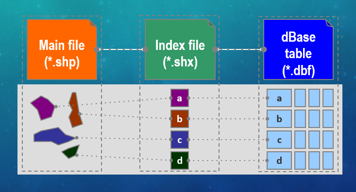
What does a .shp do
hold geometry

what does a .shx do
hold indices

what does a .dbf stand for and do
Database table, holds attributes

what does a .prj do
projection info
other optional data files in a shapefile include
Ancillary files (*.sbn, etc)
Metadata files (*.htm, .xml, .txt)
Parts of a Shapefile
A feature dataset contains
feature classes
Metadata is FAIR
Findable, accessible, interoperable, usable
Natural Data
represent natural real world features
Artificial Data
Represents artificial features like utilities and infrastucture
Planimetric Data
features that have a physical manifestation in the real world
Cadastral Data
Politically or legally defined by not visible, like parcels
Discrete Data
Data that are limited to a finite number
of potential values.
Continuous Data
Data that can take on an infinite number of
potential values
Nominal Data
names objects, but does not allow
comparisons between the different objects
Classified, e.g. land use, soils map
Ordinal Data
Ranked (classification based on a single spectrum
representing a single set of circumstances) , eg road type, school district ranks
Interval Data
Relative, ZEROES MEAN SOMETHING, like temperature, pH
Ratio Data
Absolute, ZERO MEANS NOTHING, length, height, rainfall concentration
Integer cell values are best for
representing categorical (discrete) data
Floating point cell values are good to represent the
Continuous Surfaces
Hybrid data models include
Geodatabase (esri proprietary) and Geospatial PDF (portable document format from Adobe), Geopackage (Open source), KML (Google Earth)
What is a Record?
A row on a table
What is a field?
A column on a table
What is an attribute value?
A cell in a table
Precision in a data structure is
Number of significant digits allowed
Scale in a data structure is
Number of decimal places allowed
What does BLOB stand for
Binary Large Object
What does GUID stand for
Globally Unique Identifier
When did databases begin to be used
1960s
What is a database model
a set of constraints that describe the organization of
data
Flat Database
A spreadsheet whereby all data are stored in a single, large table
Hierarchical Database
Composed of records that are connected by links, 1:M

Hierarchical Database Example

Network Database
Client server architecture that Reduces redundancy, 1:M or M;M, faster processing and better search

Network Database Example

Relational Database
Dominates GIS, series of tables linked by keys

In relational databases a table is called a
Relation
In relational database a row is called a
tuple
In a relational database a column is called an
attribute
Relational Database advantages
tables separately prepared, maintained, reduces redundancy
DBMS
Controls storage, retrieval, maintenance, and modification of large datasets, Allows users to deal with data without having to understand storage and
structure of database
DBMS is accessed through
SQL, Microsoft Access
First RDBMS was built when and where
at MIT in the early 1970s
What is RDBMS
A software package that records information in such a way that data can be accessed without reorganization of the tables
database schema meaning
DEFINES THE PHYSICAL
STRUCTURE ALONG WITH RULES, RELATIONSHIPS, AND
PROPERTIES OF EACH DATASET WITHIN THE GEODATABASE
what is a schema report
A human readable Excel, JSON, PDF, or HTML report detailing how the geodatabase schema is defined.
should you define PKs (primary keys) when not required?
yuh
3 rules of tidy data
Each variable forms a column, and contains values.
• Each observation forms a row.
• Each type of observational unit forms a table.
Wickham’s third rule of tidy data aligns with
the relational database model, because it reduces redundancy
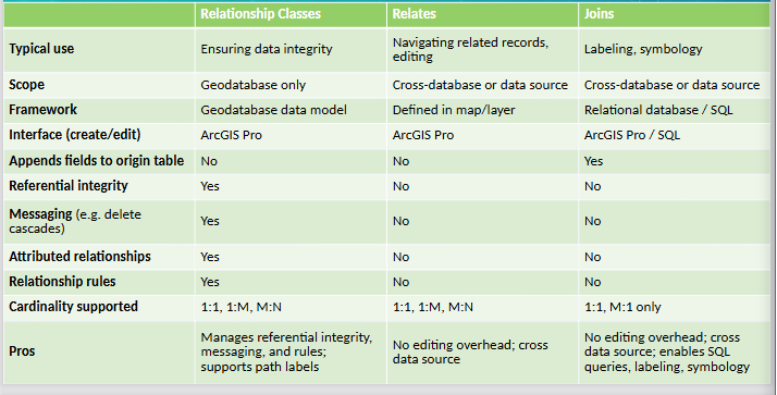
What does Relate do
Pointer between related datasets, defined as a layer property.
What does a Join do
Appends origin dataset with destination dataset
Advantage of Relate
Improved editing performance
Advantage of Join
good for labeling and symbology
Cardinality is
one-to-one, one-to-many, many-to-one, or many-to-many
1:1
Every feature has exactly one related record in the other table
1:M
Features in one table may have more than one related record in the other table
M:1
Multiple features in one table have one related record in the other table
M:M
Multiple features in one table have multiple records in another
Relate supports what cardinalities
One to many and many to many, it defines the link between datasets
Join supports what cardinalities
One to One and Many to one.
Relationship classes support what type of cardinality
All types, and related objects update automatically
Comparing relationships
What is an Aspatial query
Select by attribute
What is SQL
(Structured Query Language) is commonly used computer language
developed to query attribute data within a RDBMS
What is a clause
A grammatical unit in SQL and a language element that includes Select, From, Where, Order By, Having
Select clause
denotes what attribute table fields you wish to view
From clause
denotes the attribute table in which the information resides.
Where clause
denotes the user-defined criteria for the attribute information that must be met in order to be included in the output set
Order By Clause
denotes the sequence in which the output set will be displayed.
Having clause
denotes the predicate used to filter output from the ORDER BY clause.
Relational SQL operator
A construct that tests a relation between two entities using symbols like < or >
Arithmetic SQL operator
Include mathematical functions such as addition (+), subtraction (-), multiplication
(*), and division (/
Boolean SQL operator
A construct that performs a logical comparison
• Include the statements AND, OR, XOR, and NOT
What is XOR
either/or

4 types of spatial query
Distance, Containment, Intersection, Adjacency