Intro to Remote Sensing- Airborne Remote Sensing

0.0(0)
Studied by 0 people
call kaiCall Kai
Locked
learnLearn
examPractice Test
spaced repetitionSpaced Repetition
heart puzzleMatch
flashcardsFlashcards
GameKnowt Play
Card Sorting

1/16

encourage image

There's no tags or description

Looks like no tags are added yet.

Last updated 3:38 AM on 9/24/26
Name
Mastery
Learn
Test
Matching
Spaced
Call with Kai
Chat

No analytics yet

Send a link to your students to track their progress

17 Terms

1
New cards

Camera Systems

Passive optical sensors that use a lens (B) to acquire a snapshot of an area (A) and to form an image at the focal plane (C)

  • Optical Sensors: 0.3-15 μm


<p><span style="background-color: transparent;">Passive optical sensors that use a lens (B) to acquire a snapshot of an area (A) and to form an image at the focal plane (C)</span></p><ul><li><p><span style="background-color: transparent;">Optical Sensors: 0.3-15 μm</span></p></li></ul><p></p>
2
New cards

Vantage Point

The orientation of the camera relative to the ground during acquisition; camera orientation

3
New cards

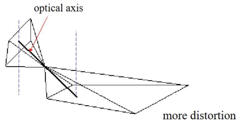
Optical Axis

The straight, imaginary line passing through the geometric center of an imaging sensor's lens system along which light rays are focused to form an image

4
New cards

Vertical Aerial Photography

Obtained when the camera’s optical axis is within ±3° of being vertical to the earth’s surface

  • Used to create planimetric, topographic, and orthophotomaps, and DEMs using fundamental photogrammetric principles


<p><span style="background-color: transparent;">Obtained when the camera’s optical axis is within ±3° of being vertical to the earth’s surface</span></p><ul><li><p><span style="background-color: transparent;">Used to create planimetric, topographic, and orthophotomaps, and DEMs using fundamental photogrammetric principles</span></p></li></ul><p></p>
5
New cards

Oblique Aerial Photography

Obtained if the camera’s optical axis deviates more than 3° from vertical

  • Useful for covering very large areas in a single image and for depicting terrain relief and scale

<p><span style="background-color: transparent;">Obtained if the camera’s optical axis deviates more than 3° from vertical</span></p><ul><li><p><span style="background-color: transparent;">Useful for covering very large areas in a single image and for depicting terrain relief and scale</span></p></li></ul><p></p>
6
New cards

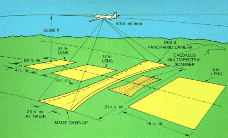
Flight Height (Altitude)

Altitude of the camera (H) above ground level (AGL) for a given focal length

  • The higher the altitude, the larger the area

  • The lower the altitude, the smaller the area


<p><span style="background-color: transparent;">Altitude of the camera (H) above ground level (AGL) for a given focal length</span></p><ul><li><p><span style="background-color: transparent;">The higher the altitude, the larger the area</span></p></li><li><p><span style="background-color: transparent;">The lower the altitude, the smaller the area</span></p></li></ul><p></p>
7
New cards

Focal Length (f)

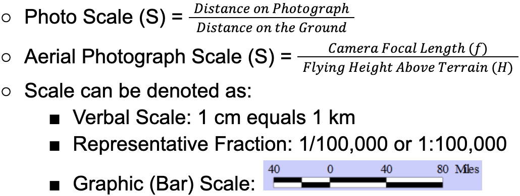
Distance between the lens and focal plane

<p><span style="background-color: transparent;">Distance between the lens and focal plane</span></p>
8
New cards

Scale


<p></p>
9
New cards

View Angle

The field of view of a camera

  • Given the same flight height, viewing angle is determined by the focal length

  • The smaller the focal length, the larger the view angle


<p><span style="background-color: transparent;">The field of view of a camera</span></p><ul><li><p><span style="background-color: transparent;">Given the same flight height, viewing angle is determined by the focal length</span></p></li><li><p><span style="background-color: transparent;">The smaller the focal length, the larger the view angle</span></p></li></ul><p></p>
10
New cards

Ground Coverage

The actual area on the ground that one air photograph covers

  • Determined by the altitude and the camera’s viewing angle

<p><span style="background-color: transparent;">The actual area on the ground that one air photograph covers</span></p><ul><li><p><span style="background-color: transparent;">Determined by the altitude and the camera’s viewing angle</span></p></li></ul><p></p>
11
New cards

Advantages and Disadvantages of Aerial Photography (Films)

  • Advantages

    • High resolution (ground)

    • Flexibility

    • High geometric reliability

    • Relatively inexpensive

  • Disadvantages

    • Day light exposure (10:00 am - 2:00 pm) required

    • Poorer contrast at shorter wavelengths

    • Film non-reusable

    • Inconvenient

    • Inefficient for digital analysis


12
New cards

Panchromatic Imaging

Sensor is a single channel detector sensitive to radiation in a broad wavelength range

  • Where the wavelength range coincides with the visible range, the resulting image resembles a “black-and-white” photograph


<p><span style="background-color: transparent;">Sensor is a single channel detector sensitive to radiation in a broad wavelength range</span></p><ul><li><p><span style="background-color: transparent;">Where the wavelength range coincides with the visible range, the resulting image resembles a “black-and-white” photograph</span></p></li></ul><p></p>
13
New cards

Multispectral Imaging

With multispectral, or multiband data, there are several layers, or values for each pixel, each representing a different “cannel/band” or reflectance in a wavelength spectrum

  • Each “band” or “channel” is sensitive to radiation within a different band of wavelength


<p><span style="background-color: transparent;">With multispectral, or multiband data, there are several layers, or values for each pixel, each representing a different “cannel/band” or reflectance in a wavelength spectrum</span></p><ul><li><p><span style="background-color: transparent;">Each “band” or “channel” is sensitive to radiation within a different band of wavelength</span></p></li></ul><p></p>
14
New cards

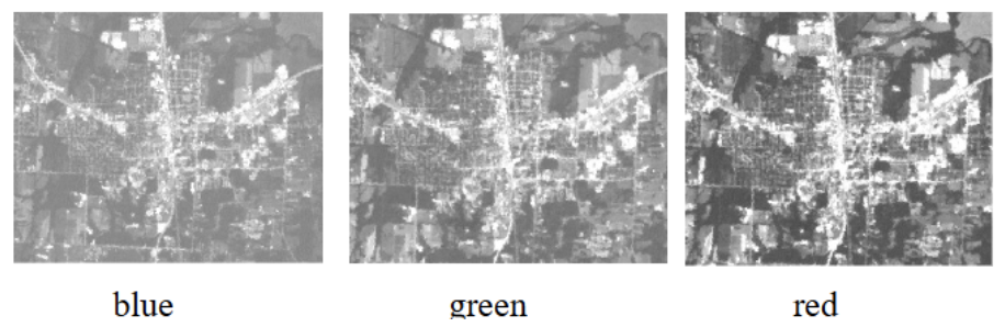
Displaying Multispectral Bands Separately

  • These bands can be looked at separately

  • One band from a multispectral image would be displayed as a grayscale image, with each pixel represented by a grayscale value

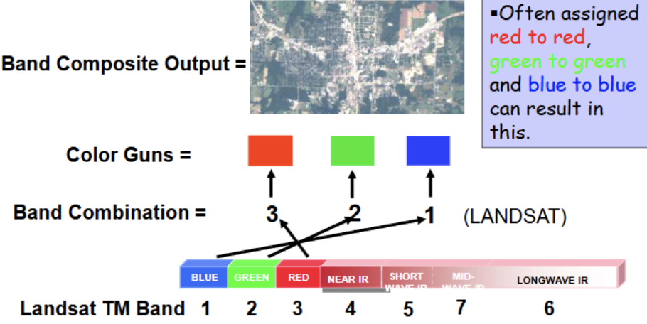
  • These bands can be combined to make “composite” images by assigning three of the bands to the red, green, and blue channels (on computer monitor)

<ul><li><p><span style="background-color: transparent;">These bands can be looked at separately</span></p></li><li><p><span style="background-color: transparent;">One band from a multispectral image would be displayed as a grayscale image, with each pixel represented by a grayscale value</span></p></li><li><p><span style="background-color: transparent;">These bands can be combined to make “composite” images by assigning three of the bands to the red, green, and blue channels (on computer monitor)</span></p></li></ul><p></p>
15
New cards

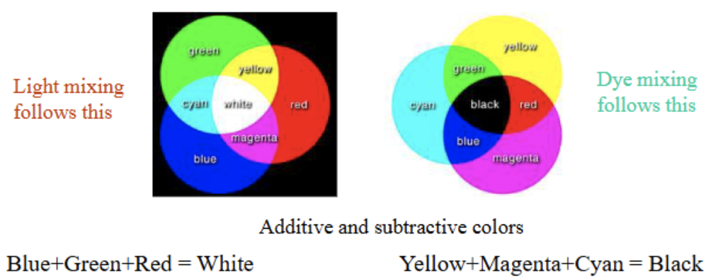
Color Types

  • Additive Primaries- red, green, and blue

  • Subtractive Primaries- cyan, magenta, and yellow

  • Displaying image is based on additive mixing of primary colors

<ul><li><p><span style="background-color: transparent;">Additive Primaries- red, green, and blue</span></p></li><li><p><span style="background-color: transparent;">Subtractive Primaries- cyan, magenta, and yellow</span></p></li><li><p><span style="background-color: transparent;">Displaying image is based on additive mixing of primary colors</span></p></li></ul><p></p>
16
New cards

True Color Composite

Bands are assigned to color channels in such a way that colors in the image roughly correspond with the colors in the real world
<p><span style="background-color: transparent;">Bands are assigned to color channels in such a way that colors in the image roughly correspond with the colors in the real world</span></p>
17
New cards

False Color Composite

Shows colors that don’t really exist in that location

  • Ex. Color Infrared Composite


<p><span style="background-color: transparent;">Shows colors that don’t really exist in that location</span></p><ul><li><p><span style="background-color: transparent;">Ex. Color Infrared Composite</span></p></li></ul><p></p>