Exam 3 - Geoscience
1/217
There's no tags or description
Looks like no tags are added yet.
Name | Mastery | Learn | Test | Matching | Spaced |
|---|
No study sessions yet.
218 Terms
How does physical weathering change the surface area of rocks and affect the rate of chemical weathering?
A. Increases surface area and thereby decreases chemical weathering
B. Decreases surface area and thereby decreases chemical weathering
C. Increases surface area and thereby increases chemical weathering
D. Decreases surface area and thereby increases chemical weathering
C. Increases surface area and thereby increases chemical weathering
What will chemical weathering do to the rate of physical weathering?
A. Decreases physical weathering
B. Increases physical weathering
C. No change--the processes are separate
B. Increases physical weathering
What combination of conservation techniques will best reduce soil loss from a sloped field?
A. Decreasing slope angle; plowing across the slope
B. Decreasing slope angle; plowing down the slope
C. Increasing slope angle; plowing across the slope
D. Increasing slope angle; plowing down the slope
A. Decreasing slope angle; plowing across the slope
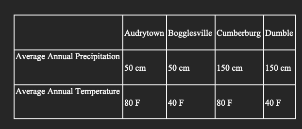
Identical marble statues were erected at the same time in four cities with the following climate characteristics.
Using the chart above, which town's statue will undergo the most weathering in a 50-year period?
A. Audrytown
B. Bogglesville
C. Cumberburg
D. Dumble
C. Cumberburg
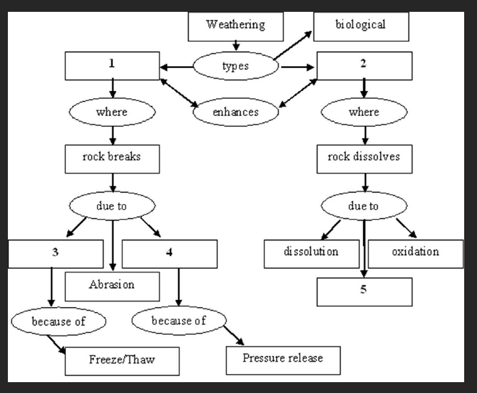
Complete the following weathering concept map by selecting the correct term for number 1.
A. Hydrolysis
B. Physical
C. Wedging
D. Chemical
E. Unloading
B. Physical
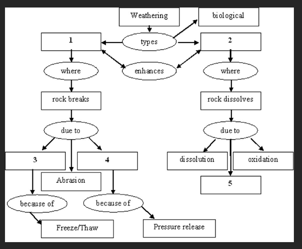
Complete the following weathering concept map by selecting the correct term for number 2.
A. Hydrolysis
B. Physical
C. Wedging
D. Chemical
E. Unloading
D. Chemical
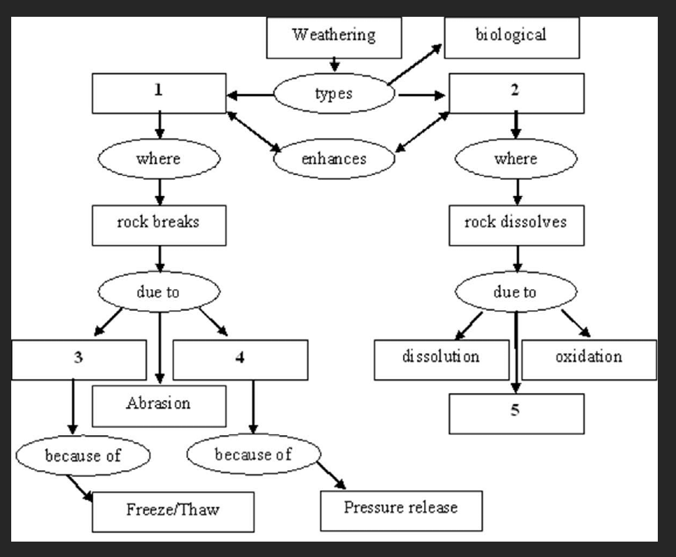
Complete the following weathering concept map by selecting the correct term for number 3.
A. Hydrolysis
B. Physical
C. Wedging
D. Chemical
E. Unloading
C. Wedging
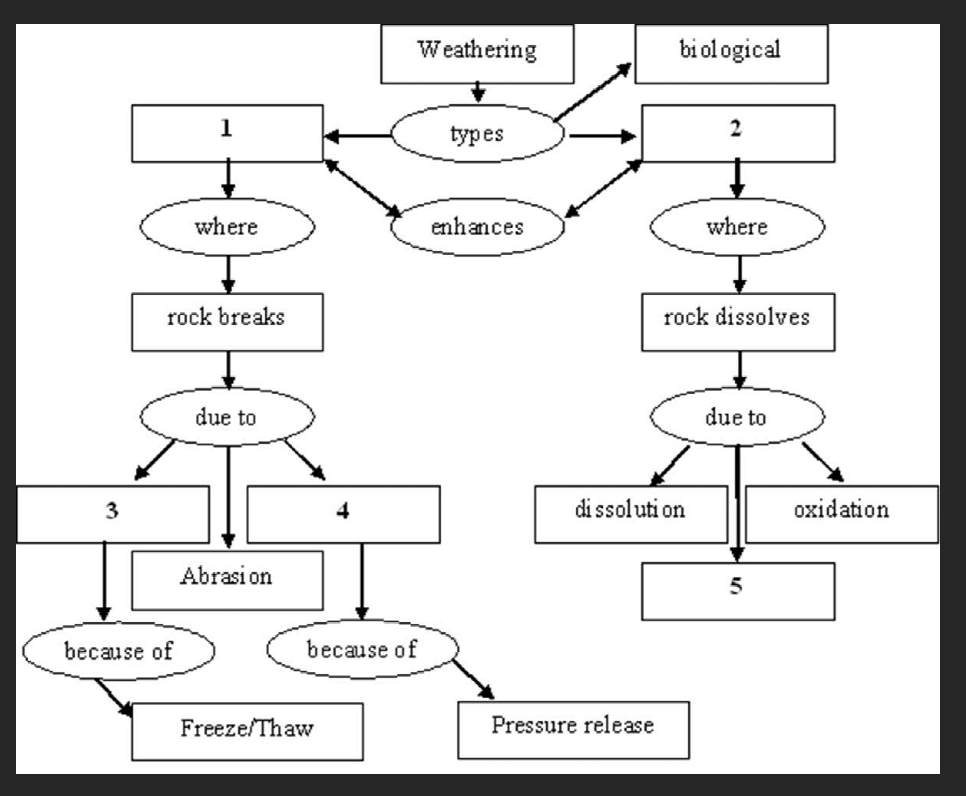
Complete the following weathering concept map by selecting the correct term for number 4.
A. Hydrolysis
B. Physical
C. Wedging
D. Chemical
E. Unloading
E. Unloading
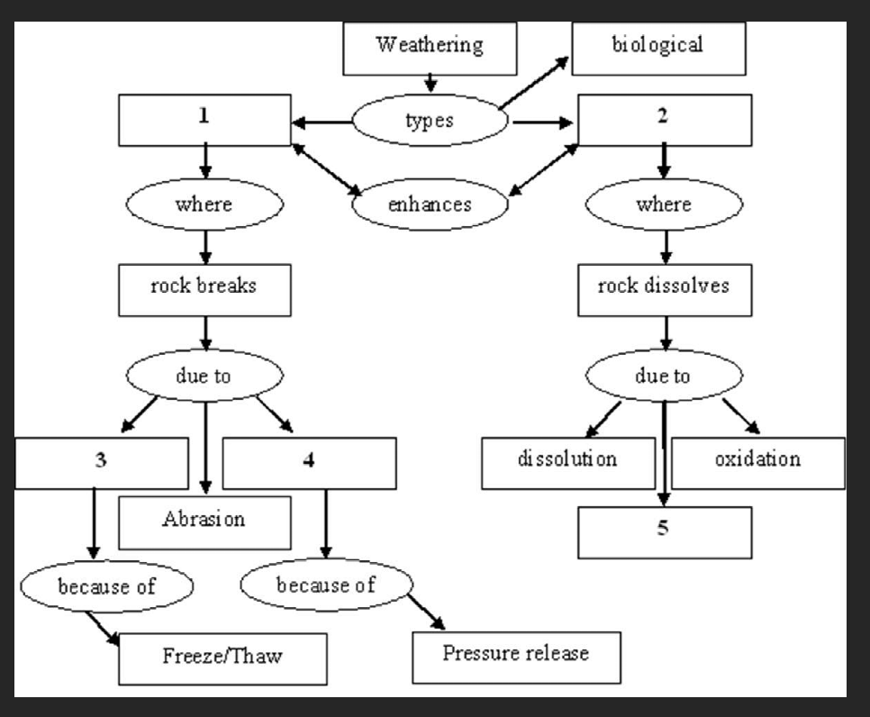
Complete the following weathering concept map by selecting the correct term for number 5.
A. Hydrolysis
B. Physical
C. Wedging
D. Chemical
E. Unloading
A. Hydrolysis
The following is from Environmental Compliance in U.S. Agricultural Policy: Past Performance and Future Potential, by Roger Claassen, Vince Breneman, Shawn Bucholtz, Andrea Cattaneo, Robert Johansson, and Mitch Morehart, AER-832, USDA/ERS, June 2004.
Since its inception in the 1930s, U.S. agricultural policy has been designed to support farmers' incomes while promoting soil conservation practices. By the 1970s, however, policymakers recognized that existing farm price and income support programs were not always consistent with soil conservation efforts. An unintended effect of these programs was to encourage producers to maintain or expand production of relatively erosive crops, such as row crops (corn, cotton, soybeans), sometimes on highly erosion-prone soils. At the same time, the Government was helping farmers reduce soil erosion and related damages through conservation cost-sharing programs. Policymakers further recognized—aside from concerns about consistency—that farm program payments could be used as incentives to encourage better conservation behavior.
What hypothesis is discussed in this passage?
A. Incentive programs were encouraging soil conservation as intended.
B. Incentive programs were not encouraging soil conservation as intended.
C. Incentive programs were having no effect on soil conservation.
B. Incentive programs were not encouraging soil conservation as intended.
Match the causes of soil erosion with the soil conservation practice intended to reduce that erosion.
Wind velocity:
A. Keep soil covered
B. Contour plowing
C. Provide shelter for fields
D. Return organic matter to soil
C. Provide shelter for fields
Match the causes of soil erosion with the soil conservation practice intended to reduce that erosion.
Character of the soil:
A. Keep soil covered
B. Contour plowing
C. Provide shelter for fields
D. Return organic matter to soil
D. Return organic matter to soil
Match the causes of soil erosion with the soil conservation practice intended to reduce that erosion.
Maintain vegetation:
A. Keep soil covered
B. Contour plowing
C. Provide shelter for fields
D. Return organic matter to soil
A. Keep soil covered
Match the causes of soil erosion with the soil conservation practice intended to reduce that erosion.
Slope of the land surface:
A. Keep soil covered
B. Contour plowing
C. Provide shelter for fields
D. Return organic matter to soil
B. Contour plowing
What processes play the most important role in soil formation?
A. Evaporation and transpiration
B. Weathering and biological activity
C. Compaction and cementation
B. Weathering and biological activity
What process is the removal of materials?
A. Chemical weathering
B. Physical weathering
C. Erosion
C. Erosion
What type of chemical weathering causes rust to form?
A. Dissolution
B. Hydrolysis
C. Oxidation
C. Oxidation
What type of chemical weathering occurs when minerals dissolve in water?
A. Dissolution
B. Hydrolysis
C. Oxidation
A. Dissolution
What is the main way by which ions are removed from soils?
A. Organic activity
B. Leaching
C. Transport
B. Leaching
Which is the correct order for a soil horizon from the surface down?
A. O, E, C, B, A
B. O, A, E B, C
C. E, C, B, O, A
D. E, O, B, B, A
B. O, A, E B, C
Where does eluviation occur?
A. A
B. B
C. C
D. O
E. E
E. E
Which soil horizon do we walk on?
A. A horizon
B. B horizon
C. C horizon
D. O horizon
D. O horizon
Which region of the United States experiences the most soil erosion by wind?
A. The Great Plains
B. Lower Mississippi Valley
C. The Midwest
D. Central Valley of California
A. The Great Plains
Fractured rocks weather more rapidly than unfractured rocks.
True False
True
The volume decreases when water changes to ice.
True False
False
Carbonic acid forms by a combination of carbon dioxide and oxygen.
True False
True
The pH value of a solution decreases with increasing concentrations of hydrogen ions.
True False
False
Regolith is essentially the same as soil.
True False
False
Soils are a non-renewable resource.
True False
True
Biologic weathering is essential for soil formation.
True False
True
Biologic weathering occurs at both the macro- and micro-levels.
True False
True
Quartz is easily weathered compared to other minerals.
True False
False
Quartz is easily weathered compared to other minerals.
True False
False
Permeability describes how rapidly water moves through a rock.
True False
True
High temperatures increase the rate of chemical weathering.
True False
True
Basalt parent rock would form a soil very similar to that formed from granite.
True False
False
What would you likely observe if you saw a debris flow?
A. Material moving as a unit down a slope.
B. Material moving chaotically down a slope.
C. Material moving slowly down a slope.
B. Material moving chaotically down a slope.
Are you likely to observe creep as it occurs?
A. Yes, it happens very rapidly.
B. Yes, it happens very slowly.
C. No, it happens very rapidly.
D. No, it happens very slowly.
D. No, it happens very slowly.
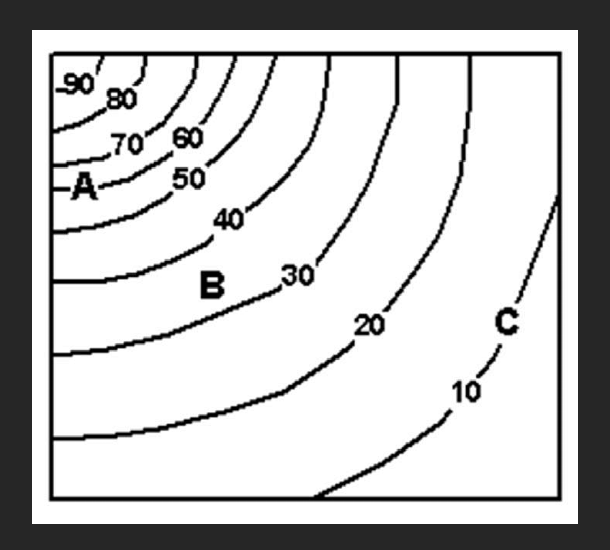
Which of the three labeled locations on the topographic map above has the highest risk of mass wasting? (Numbers represent elevation in meters above sea level.)
A. A
B. B
C. C
D. All three locations are equal.
A. A
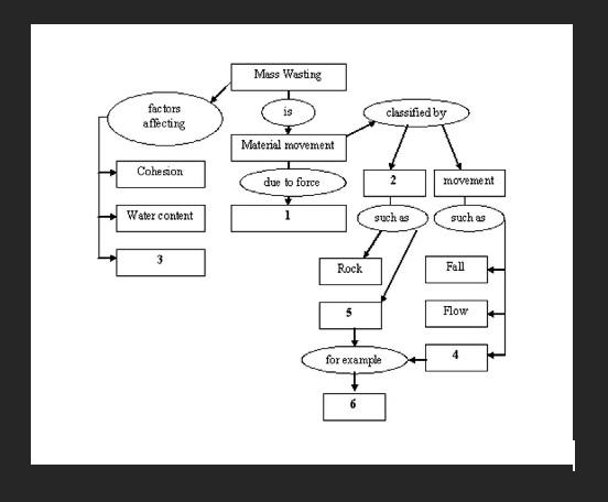
Complete the concept map for number 1.
A. Wind
B. Water
C. Slope
D. Gravity
D. Gravity
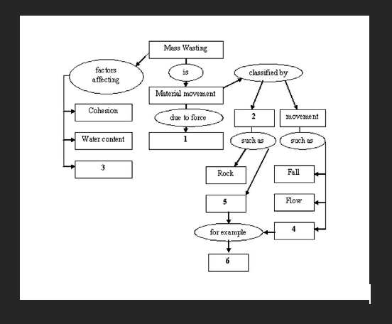
Complete the concept map for number 2.
A. Material
B. Regolith
C. Slide
D. Slump
E. Slope
A. Material
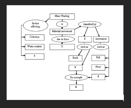
Complete the concept map for number 3.
A. Material
B. Regolith
C. Slide
D. Slump
E. Slope
E. Slope
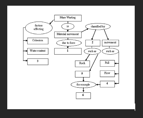
Complete the concept map for number 4.
A. Material
B. Regolith
C. Slide
D. Slump
E. Slope
C. Slide
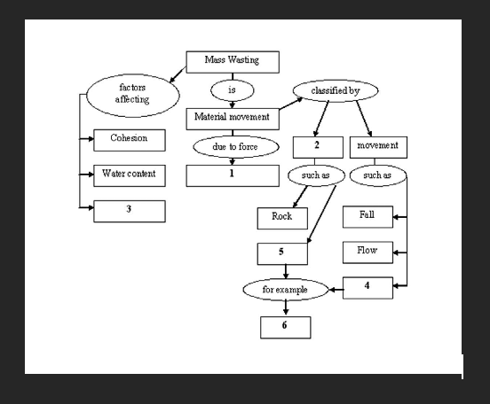
Complete the concept map for number 5.
A. Material
B. Regolith
C. Slide
D. Slump
E. Slope
B. Regolith
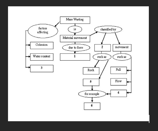
Complete the concept map for number 6.
A. Material
B. Regolith
C. Slide
D. Slump
E. Slope
D. Slump
Use the following information to answer this question. There are two main approaches to reducing the risk from landslides; hard and soft. Hard approaches involve construction of retaining walls, slope reduction, and drainage improvements. Soft approaches include zoning restrictions and land use regulations. Read the following mass wasting scenarios to determine if the event involved hard, soft, or both approaches.
A homeowner has the foundation of his house reinforced to lessen the effects of liquefaction.
A. Hard
B. Soft
C. Both
A. Hard
Use the following information to answer this question. There are two main approaches to reducing the risk from landslides; hard and soft. Hard approaches involve construction of retaining walls, slope reduction, and drainage improvements. Soft approaches include zoning restrictions and land use regulations. Read the following mass wasting scenarios to determine if the event involved hard, soft, or both approaches.
City council passes an ordinance preventing a development from building on a historical landslide.
A. Hard
B. Soft
C. Both
B. Soft
Use the following information to answer this question. There are two main approaches to reducing the risk from landslides; hard and soft. Hard approaches involve construction of retaining walls, slope reduction, and drainage improvements. Soft approaches include zoning restrictions and land use regulations. Read the following mass wasting scenarios to determine if the event involved hard, soft, or both approaches.
Retaining walls are built along a road and irrigation is reduced on the fields above.
A. Hard
B. Soft
C. Both
C. Both
Read the following USGS statement and answer this question.
USGS Statement on Bluebird Canyon Landslide in Laguna Beach, California
In the early morning of June 1, 2005, a landslide began moving in the Bluebird Canyon area of Laguna Beach, California. No rainfall or earthquake activity occurred during or immediately before the landslide movement. This movement is almost certainly related to the extremely heavy winter rains that occurred from December through February. Rainfall from the winter season has been slowly percolating downward through the soil and is gradually raising ground-water levels. As ground water rises, slopes can become unstable and begin to move, even if no rain is presently occurring. The current landslide might enlarge to include areas upslope or other adjacent areas within the next few days and weeks. The continuing infiltration of water from the winter rainy season could trigger other deep landslides in the southern California region over the next few weeks and months. (from http://www.usgs.gov/homepage/landslide_laguna.asp)
What hypothesis is presented to explain the landslide?
A. An earthquake triggered it
B. A recent heavy rain triggered it
C. Rising groundwater triggered it
C. Rising groundwater triggered it
Read the following USGS statement and answer this question.
USGS Statement on Bluebird Canyon Landslide in Laguna Beach, California
In the early morning of June 1, 2005, a landslide began moving in the Bluebird Canyon area of Laguna Beach, California. No rainfall or earthquake activity occurred during or immediately before the landslide movement. This movement is almost certainly related to the extremely heavy winter rains that occurred from December through February. Rainfall from the winter season has been slowly percolating downward through the soil and is gradually raising ground-water levels. As ground water rises, slopes can become unstable and begin to move, even if no rain is presently occurring. The current landslide might enlarge to include areas upslope or other adjacent areas within the next few days and weeks. The continuing infiltration of water from the winter rainy season could trigger other deep landslides in the southern California region over the next few weeks and months. (from http://www.usgs.gov/homepage/landslide_laguna.asp)
What prediction do scientists make in this scenario?
A. Rainfall percolates through the soil.
B. Other areas may fail.
C. Future earthquakes may cause landslides.
B. Other areas may fail.
Read the following USGS statement and answer this question.
USGS Statement on Bluebird Canyon Landslide in Laguna Beach, California
In the early morning of June 1, 2005, a landslide began moving in the Bluebird Canyon area of Laguna Beach, California. No rainfall or earthquake activity occurred during or immediately before the landslide movement. This movement is almost certainly related to the extremely heavy winter rains that occurred from December through February. Rainfall from the winter season has been slowly percolating downward through the soil and is gradually raising ground-water levels. As ground water rises, slopes can become unstable and begin to move, even if no rain is presently occurring. The current landslide might enlarge to include areas upslope or other adjacent areas within the next few days and weeks. The continuing infiltration of water from the winter rainy season could trigger other deep landslides in the southern California region over the next few weeks and months. (from http://www.usgs.gov/homepage/landslide_laguna.asp)
What empirical data are mentioned here?
A. Rainfall
B. Rising groundwater levels
C. Earthquake levels
A. Rainfall
What force must be overcome in order for mass wasting to occur in most cases?
A. Gravity
B. Friction
C. Saturation
B. Friction
Which of the following slopes would be at greatest risk for mass wasting?
A. 10º slope
B. 20º slope
C. 30º slope
C. 30º slope
What direction is the force of friction compared to the surface of a slope?
A. Parallel
B. Perpendicular
C. Oblique
A. Parallel
What factor was most important in the December, 1991, landslide at Caraballeda, Venezuela?
A. Steep slopes
B. Urban development
C. Excessive rains
C. Excessive rains
What is a coherent mass of rock that moves on a planar sliding surface?
A. Rock fall
B. Slump
C. Rockslide
D. Debris flow
C. Rockslide
What is the downslope movement of unconsolidated material on a curved slip surface?
A. Rock fall
B. Slump
C. Rockslide
D. Debris flow
B. Slump
Which involves the most water?
A. Mudflow
B. Slump
C. Rockslide
D. Debris flow
A. Mudflow
What criteria are primarily used to classify mass wasting?
A. Land use and velocity of movement
B. Volume of water and velocity of movement
C. Type of material and type of movement
D. Slope angle and volume of precipitation
C. Type of material and type of movement
What type of weathering environment increases the chance of mass wasting?
A. Rapid weathering
B. Slow weathering.
A. Rapid weathering
The term "landslide" applies to several forms of mass wasting.
True False
True
Rockfalls happen when boulders on rocky cliffs dislodge and fall.
True False
True
Rockslides occur when large sheets of rock break free along preexisting, structurally weak surfaces and move down a slope.
True False
True
Slumps occur when soils slowly move down a linear slope.
True False
False
Mudflows and debris flows occur when water and loose materials move down a slope like a thick liquid.
True False
True
Creep is the rapid movement of material downslope.
True False
False
The transfer of rock material down slope under the influence of gravity is termed __________.
a. weathering
b. erosion
c. mass wasting
d. exfoliation
c. mass wasting
Which of the following terms is used to describe the way materials move during a mass wasting event?
a. fall
b. slide
c. flow
d. all of these
d. all of these
The controlling force of mass wasting is __________.
a. water
b. gravity
c. composition
d. earthquakes
b. gravity
The release of water vapor to the atmosphere by plants is called __________.
a. evaporation
b. degassing
c. transpiration
d. infiltration
c. transpiration
____________ is not part of the water cycle?
a. Water evaporating from a lake
b. Water infiltrating into the soil and bedrock
c. Calcium carbonate dissolving in soil water and groundwater
d. Water moving into creeks and streams following a rainstorm
c. Calcium carbonate dissolving in soil water and groundwater
Which of the following is the correct definition of stream gradient?
a. the distance traveled by water in a channel times a drop in elevation
b. the drop in elevation of a stream divided by the distance the water travels
c. the water pressure at the bottom of the stream divided by the stream’s width
d. the increase in discharge of a stream per unit drop in elevation
b. the drop in elevation of a stream divided by the distance the water travels
Which one of the following factors does NOT influence stream velocity?
a. channel size and shape
b. laminar flow
c. discharge
d. gradient
c. discharge
The world's largest river in terms of discharge is the __________.
a. Congo
b. Mississippi
c Nile
d. Amazon
d. Amazon
If you were to examine the longitudinal profile of a typical river, you would probably find that the gradient is __________.
a. steepest near the mouth
b. steepest near the head
c. the same at both the head and mouth
d. none of these
b. steepest near the head
____________ make up the suspended loads of most rivers and streams.
a. Dissolved ions and sand
b. Dissolved salts
c. Silt and clay-sized, detrital grains
d. Sand and gravel that move during floods
c. Silt and clay-sized, detrital grains
At a bend in a river, the main erosion is __________.
a. on the outside of the bend
b. on the inside of the bend
c. both outside and inside the bend
d. at an oxbow lake
a. on the outside of the bend
___________ describes the total sediment load transported by a stream.
a. Capacity
b. Discharge
c. Competence
d. Hydro-load factor
a. Capacity
At the head of a delta, the major channel splits into smaller channels that follow different paths to the sea. These smaller channels are known as ____________.
a. endotributaries
b. exotributaries
c. distributaries
d. cotributaries
c. distributaries
A natural levee is __________.
a. an erosional feature
b. a depositional feature
c. essentially parallel to its stream channel
d. both b and c
d. both b and c
Rejuvenation of a stream may be due to __________.
a. rising of sea level
b. uplift of land
c. a decreased gradient
d. thermal expansion
b. uplift of land
The suspended load of a stream __________.
a. is deposited before the bed load
b. is highly soluble substances
c. moves along the bottom
d. usually consists of fine particles
d. usually consists of fine particles
A ____________ stream pattern is developed only on growing mountains like volcanoes or where the land surface is tectonically doming upward.
a. radial
b. dendritic
c. boreal
d. trellis
a. radial
A ____________ stream pattern develops on lands underlain by tilted or folded, alternating hard and soft, sedimentary strata.
a. dendritic
b. radial
c. trellis
d. boreal
a. dendritic
The most common drainage pattern is __________.
a. dendritic
b. radial
c. trellis
d. boreal
a. dendritic
____________ is an abandoned, cutoff, meander loop.
a. A bulltrail
b. An oxbow
c. A cowhock
d. A gatorback
b. An oxbow
A stream begins at an elevation of 200 meters and flows a distance of 400 kilometers to the ocean? What is the average gradient?
a. 2m/km
b. 2km/m
c. 0.5m/km
d. 0.5 km/in
c. 0.5m/km
____________ are characteristics of downcutting streams and a youthful stage of valley evolution.
a. Rapids and lots of whitewater
b. Wide floodplains
c. A U-shaped, cross-valley profiles
d. Meandering channels and natural levees
a. Rapids and lots of whitewater
____________ generally constitutes the highest percentage of the annual sediment load moved by a stream.
a. Bed load
b. Dissolved load
c. Suspended load
d. Saltation load
c. Suspended load
A ____________ drainage pattern is common in the Appalachian Valley and Ridge Province.
a. dendritic
b. polygonal
c. circular
d. trellis
d. trellis
Which of the following features characterize wide streams and valleys?
a. natural levees; broad floodplains
b. rapids; channel bed potholes
c. waterfalls; entrenched meanders
d. V-shaped valley cross-sections
a. natural levees; broad floodplains
As stream discharge increases __________.
a. velocity, width, and depth increase
b. only velocity increases
c. velocity, width, and depth decrease
d. only depth increases
a. velocity, width, and depth increase
The single most important erosional agent is __________.
a. running water
b. wind
c. wind
d. waves
a. running water
Permeable rock strata or sediment that transmit groundwater freely are called __________.
a. perched water tables
b. aquitards
c. springs
d. aquifers
d. aquifers
____________ would have the largest capacity to naturally remove sewage pollutants.
a. Fractured granite
b. Well-sorted, coarse gravel
c. Slightly clayey sand
d. Limestone with solution channels and caverns
c. Slightly clayey sand
When water is pumped from a well, a depression is often produced in the water table. Such a depression is a(n) __________.
a. perched water table
b. pumping dimple
c. cone of depression
d. artesian well
c. cone of depression
Which one of the following concerning artesian wells is not true?
a. the well penetrates an aquifer overlain by an aquitard
b. the well penetrates an aquifer underlain by an impermeable bed
c. the aquifer is generally inclined, and it is saturated to an elevation above the point where the well penetrates the aquifer
d. when the well penetrates the aquifer, the water rises to the bottom of the aquitard above the aquifer
d. when the well penetrates the aquifer, the water rises to the bottom of the aquitard above the aquifer
Which of the following is associated with areas of karst topography?
a. sinkholes
b. soluble rock
c. caverns
d. all of these
d. all of these
A ____________ is the icicle-like speleothem that grows down from the roof of a cavern.
a. stalandite
b. stalactite
c. stalagmite
d. slagdite
b. stalactite
____________ is the volume of voids or open space in a rock or unconsolidated material.
a. Permeability
b. Space yield
c. Porosity
d. Saturation index
c. Porosity