APES U4 Earth Systems
1/96
There's no tags or description
Looks like no tags are added yet.
Name | Mastery | Learn | Test | Matching | Spaced |
|---|
No study sessions yet.
97 Terms
List layers of the earth in order from top to middle and the states of matter ( including names and why they are that state of matter if applicable )
crust - solid matter
mantle - lower part = solid matter upper part = liquid ( convection currents ) also called athenosphere
outer core - liquid matter
inner core - solid state of matter due to the pressure
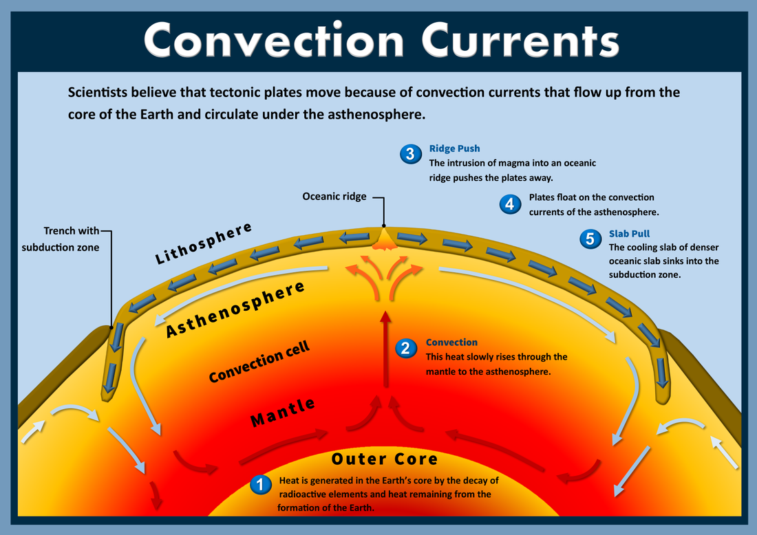
Convection currents drive… based on … and … . explain how this works
movement of tectonic plates based on density differences and magma . Magma in asthenosphere rises as its heated up. then as it reaches surface it cools down, expands, and then falls. This cycle continues. Hot cold, warm cool is what drives movement of convection.
lithosphere
the actual crust, its above the asthenosphere
Oceanic Crust is ____ and is ___ dense than continental crust and is thinner/thicker than continental crust
basalt, more, thinner
Continental crust is ___ and is ___ so we will never get more
granite, finite
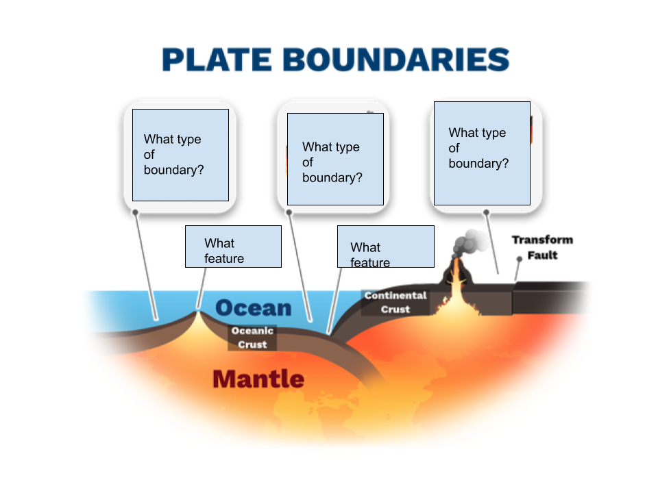
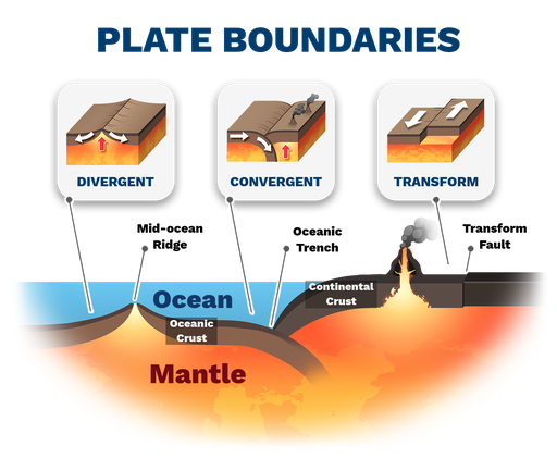
what are the 3 types of plate boundaries
Convergent, transform, and divergent
In convergent plate boundaries
Oceanic to continental forms what 2 things as the oceanic plate slides below the continental
describe what happens in an oceanic to continental
Volcanic Mountains and subduction zone forms.
The subducting plate will begin to melt. Magma will rise vertically upward to the surface. The rising magma will form a series of volcanic Mountains that form near the plate boundary.
The subduction happens as a trench forms between the two plates
If crusts of the same type converge then the ___ one will subduct
older
If new crust forms it has to be
oceanic / basalt because continental crust or granite is finite
convergent boundary continent to continent
2 plates coming together → uplift → mountains because both are equally dense
in a convergent boundary continent to continent there is no volcanic activity , why ?
SInce there is no subduction the magma doesn’t rise up n a convergent
In a convergent boundary oceanic to oceanic
What plate will subduct and why. What will form
The older plate ( with higher density ) will subduct. The subducting plate will begin to melt. Magma will rise vertically upward to the surface. The rising magma will form a series of volcanic island arcs near the plate boundary and a space will form between the plate called trenches . Trenches are proof of subduction zone
In a divergent boundary plates move apart, in oceanic to oceanic divergent boundary What will happen
magma from asthenosphere will rise to surface in the ocean.
a mid ocean ridges( mountain range in middle of ocean ) will form and at this boundary the ocean is expanding. meaning that the Atlantic ocean is expanding. T
his is called seafloor spreading because the crust is expanding.
divergent boundary continental to continental
continents spread apart forming a rift valley.
magma from asthenosphere can move vertically upward through the crack In the surface.
Once the land has been separated enough new basaltic crust will form → new ocean is forming
In a transform plate boundary
plates slide against each other
the crack in the surface between the two plates in a transform boundary is called
fault
the fault line is usually located where
in the middle of the 2 sliding plates
The transform boundary results in what and why. Give an example.
releases stored energy held in place by friction in a short period of time and results in earthquakes
can also result in tsunamis if ocean plates move with some vertical motion
ex: San Andreas fault
Tsunamis are … and are caused by…. and can result in …
tsunamis are series of waves
caused by rapid vertical displacement of water ( usually earthquake, most often at subduction zones )
devastate mangrove forests and coral reefs
destroy agriculture and native species
cause saltwater intrusion or salinization
Along the ring of fire is
the ring of fire has a ___ bottom
volcanoes
divergent
Hot spots are caused by and are
an examples is
magma that escapes from mantle and reaches the lithosphere
hot spots are areas of volcanic activity that do not occur along plate boundaries . Hot spots do not move .
ex: Hawaiian
describe how hawaii was formed
liquid in asthenosphere got hot in certain places → burn a hole in the lithosphere → magma seeps through so plate moves over as islands go away from a hotspot . As volcanoes move, the new piece of land over the hotspot will form more volcanoes
Types of rocks and definitions of each
igneous = formed from the solidification of magma on the earth’s surface ( extrusive ) or within a plate ( intrusive )
Metamorphic = formed from an intense heat or pressure usually deep within a crust
Sedimentary = formed from compaction or cementation, usually on earth’s surface
soils effectively ___ and ___ water that moves through them so they ____ water quality
clean and filter water that moves through them so they protect
In the red circles area describe what is happening. What crust is being made and being destroyed. How. And at what boundary. Plate motion is due to ____ ___ in the asthenosphere , draw in the arrows
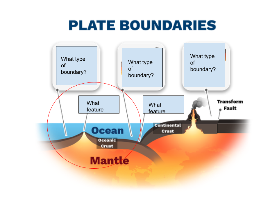
Magma is rising up as divergent plates in ocean to ocean creates a mid atlantic ridge which expands the sea floor. New oceanic crust is being created at the divergent boundary. Old oceanic crust is being destroyed in the convergent boundary for continent to land → volcanic Mountains because magma rises up because of subduction .
Plate motion is due to convection currents,
when convection currents are going down together → what boundary
when convection currents are going up together → what boundary
down → convergent
up → divergent

What types of geological activities are common in this area that make ring of fire an appropriate description. What type of plate boundaries surround the ring of fire
ocean continent - convergent = volcanic Mountains
ocean ocean - convergent = volcanic islands
the ring of fire follows the boundary of what major tectonic plate
pacific plate
why doesn’t the ring of fire stretch along the equator across the Pacific ocean
because the plate boundary near the bottom are divergent so no subduction so volcanic islands or mountains cannot emerge

3 faults in the US
san andreas
new Madrid
Wasatch
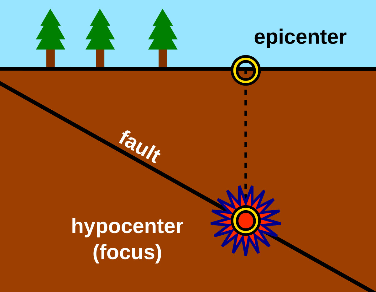
epicenter of an earthquake is
exact point on the surface of the earth directly above the location where the rock ruptures
Mass extinction , what must occur
relatively sudden, global decrease in diversity of life forms.
extinctions occur over the world
a large number of species go extinct
many types of species go extinct
the 5 mass extinctions in earth’s history
Ordovician , Devonian, Permian, Triassic, Cretaceous-Tertiary(K-T boundary )
during the K-T boundary
half of all life forms died out
Scientists predict we are in the 6th Mass extinction, what Is this called and why
holocene / anthropocene extinction
caused by human actions
decrease in wild life
Factors that impact the formation of soil ( and definition )
Climate = over long period of time and , different biomes have different soil types
Topography = slope and elevation of the land
parent material
organisms - types of decomposers and microorganisms present within the soil
time
soil is formed by
chemical and physical weathering of rocks over time
particles of soil in order from largest to smallest
sand, silt, clay
soil horizon
O - Humus
most susceptible to weathering
surface litter like leaves and other decaying matter
A - top soil
phosphorus and nitrogen are examples of some of the limiting nutrients that are found
unrenewable
mineral soil with most organic material accumulation and soil life(worms)
E - eluviation layer
sand and silt
infiltration
mostly containing of silicates
zone of leaching ( nutrients from upper horizons seep into lower horizons)
minerals are washed away by leaching so lack of minerals like clay or iron
B - subsoil
zone of accumulation = minerals like iron, clay, aluminum and organic material and other nutrients accumulate a process referred to as eluviation
little to no organic matter
C - parent material
gives soil rest of its characteristics
large layer of unbroken rocks
materials that is broken down to give soil
least weathered
R - Bed rock
Solid rock
not weathered at all
Weathering ( biological and chemical ) Include examples
Breakdown of rock to form soil
ex: lichen and moss can breakdown / primary successores
ex: wind and water, ice, animals , growing plants
chemical weathering =acid rain, rust on rocks
Biological weathering = plants growing in rocks, human activity, animal burrowing
Erosion
Movement of soil someplace else
ex: wind, agriculture, ice, gravity, water
Deposition
The dropping of sediment in a new place
ex: sand dunes , formation of an island
soil particle characteristics
Sand - largest
highest permeability and porosity
water passes through this the most
Silt - medium
Clay - smallest
Lowest permeability and porosity
Highest fertility / nutrient level
negative charge and nutrients are positive so clay attracts nutrients
high water holding capacity
Permeability =
porosity =
fertility =
permeability = ability of air/liquid to go through
porosity = pores /spaces between particles
fertility = how much nutrients ( fertile ) the soil has
farmers want soil to be ___ because …
loam
loambecause its a mixture of sand, silt, and clay so it has the best of each component
soils with a smaller particles have a ____ water holding capacity
higher
watershed characteristics and these characteristics influence what
Area
Length
Slope
soil
vegetation
divides ( boundary with other watershed )
Watershed characteristics influence rainwater flow through the watershed
runoff often causes what
erosion and picks up pollution and carries elsewhere
watershed characteristics and classifications areinfluenced by
runoff and infiltration
water table
the ground below which the ground is saturated with water, usually below infiltration
Aquifer
a body of porous rock and sediment saturated with groundwater, usually below water table
Recharge process
water infiltrates into soil and then percolates deeper into ground to replenish underground aquifers
Watershed classification differ based on runoff and infiltration rates, provide examples
urban - high runoff , low infiltration
forested = high infiltration and low runoff
Riparian zones
important component of watersheds with vegetation. Can trap and filter certain types of pollutants
polution enters watersheds from
Agricultural runoff
industrial dumping
urban runoff
erosion
solid waste
Due to runoff and infiltration some of these pollutants can enter into groundwater
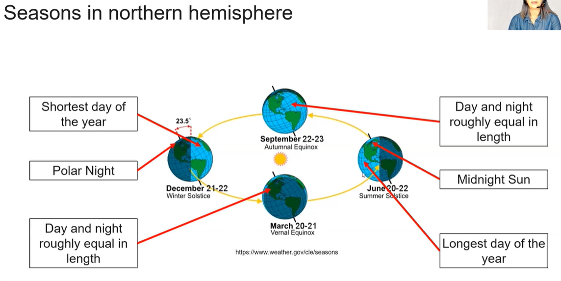
Factors affecting the amount of solar radiation reaching the earth
rotation ( 1×24 hrs )
revolution ( 1 per 365 days )
tilt of axis(23,5 degrees )
atmospheric conditions
What causes seasons
summer happens in the northern hemisphere when it is tilted towards the sun so that it gets the most direct rays. Sun rises higher and stays above the horizon longer and its rays strike the ground most directly.
7
albedo
Proportion of light that is reflected by a surface, mostly determined by a color
surfaces with a high albedo reflect more light and thus gain less heat
like ice snow
surfaces with low albedo absorb light and heat
pavement
front
boundary between two air masses
Cold front ___ warm fronts by creating a ___ , how does this work
displaces, wedge, cold air is denser than warm air so the warm air is pushed upwards
importance of atmosphere
provides O2 and CO2
absorbs solar radiation
moderates climate
transports and recycles water and nutrients
atmospheric pressure is caused by the weight of air. as a result pressure ___ as altitude ___
pressure increase and altitude decrease
pressure decreases as altitude increases
the pauses in layers ( ex: mesopause, stratopause, tropopuase ) are…
transition zones between temperature changes
layers of the atmosphere are arranged according to …
most of our weather reoccurs in what layer
temperature
Troposphere
Layers of earth’s atmosphere starting from closest to earth’s surface ( bottom of table). State shift in temperature and why.
thermosphere | increase in temperature | high energy UV radiation absorbed ( closer to sun) ; air feels cold because molecules are sparse |
mesopause/mesosphere | decrease to mesopause | air becomes thinner again |
stratopause/stratosphere | increase to stratopause | formation of ozone layer in stratosphere traps heat |
tropopause/troposphere | decrease to tropopause | air becomes thinner ( molecules farther apart |

usually the higher the altitude the lower the temperature of the air. temperature inversion is when ____ air is trapped at the ground under a layer of ___ air
cool, warm
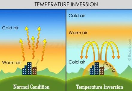
in normal conditions what happens to warm air
in temperature inversion why cant air rise to a higher altitude
what happens to air pollutants during a temperature inversion
temperature inversions are common in valleys why?
rises and then cools down
dense cold air cant rise above warm air
pollutants become trapped near the ground because the cold air cant rise and the same layer of air is staying in the same place → smog
less radiation In valley from sun so cold air under that is denser than warm air so it pulls under. cold air on top because high altitude like valleys mean colder air

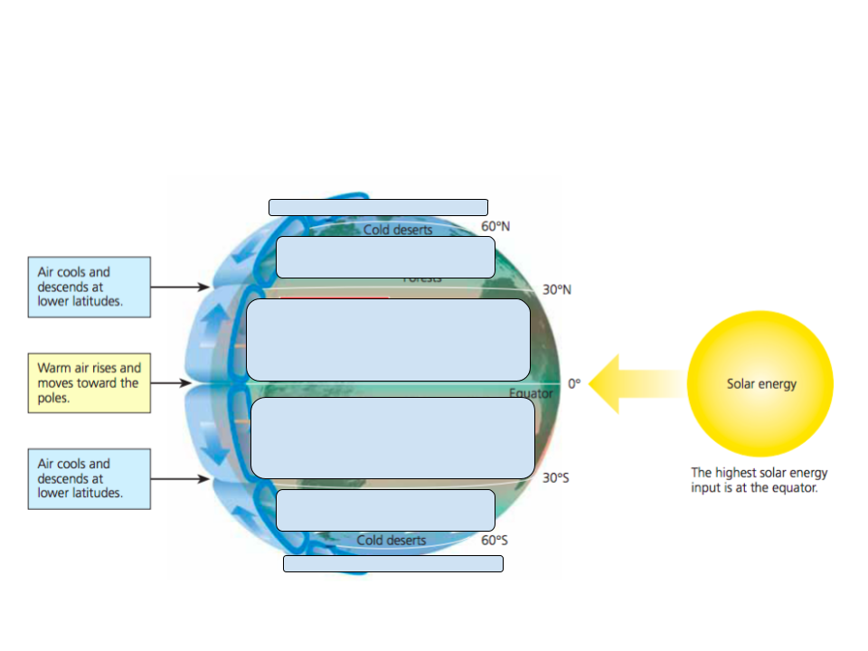
global wind patterns primary result from the most intense ___ ___ arriving at the equator resulting in ____ ___ and ___ ___
solar radiation, coriolis effect, density differences
water vapor capacity
warmer air has higher water vapor capacity ( humidity )
adiabatic heating and cooling
response to pressure changes ( air rises → lower pressure → volume expands → cools )
properties that determine air circulation patterns
air density
water vapor capacity
adiabatic heating and cooling
Hadley cells vs Ferrel cells vs Polar cells location
Ferrell cells are located in mid latitudes [ 30 -60 degrees north and south ]
Hadley cells are located in tropical near equator [ 0 to 30 north and south ]
Polar cells are located at poles ( 90 degrees north and south )
when warm air rises at the equator what happens to the water that is with it. How does this affect climate at the equator
water vapor creates warm moist air that rises
it cools down and is unable to hold onto moisture
so it rains at the equator [ tropical rainforest ]
biome at 30 degrees where cold dry air is sinking
biome at equator where warm air is and precipitation
biome at 60 degrees where warm moist air and precipitation
biome at poles where dry cold air is falling
subtropical desert
tropical rainforest
temperate forest / taiga ( small taiga in 60 degrees south )
tundra/cold desert
draw arrows and wind names
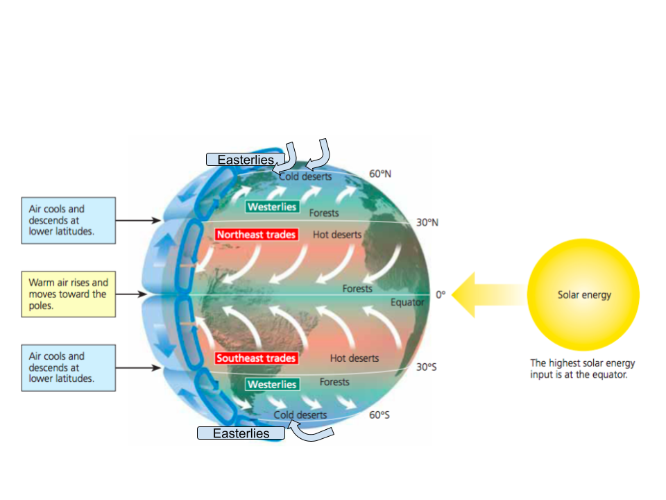
In the northern hemisphere does the coriolis effect cause winds to move in a clockwise or counter clockwise direction
counterclockwise direction

southern hemisphere air deflect ___ when it hits low pressure, due to the earths rotation
left
Because trade winds come together at equation →
intertropical convergence zone (ICZ)
at what latitudes are there low pressure
equator, 60 degrees north and south
where air is going away from earth
horse latitudes
divergent winds ( arrows moving away from each other )
60 degrees ( easterlies and westerlies), 30 degrees(westerlies and south east trade winds )
A watershed with high infiltration has what characteristics
vegetation, sandy soil
impermeable ground , clay soil, concrete, steep slopes, void of vegetation means water shed has a high __
runoff
in a rainshadow storms/cloud ____ ___ when they cross the mountain
dry out
on the leeward side of rainshadow
dry air advances and it going to be more desert
on the windward side of rain shadow
warm moist air rises and cools and condenses at the peak of mountain
are mountains the only areas that would experience a rain shadow effect
islands can too
Gyres
large scale water circulation, moves clockwise in northern hemisphere and anti clockwise in southern hemisphere
wind, earth’s rotation, and land masses → gyres
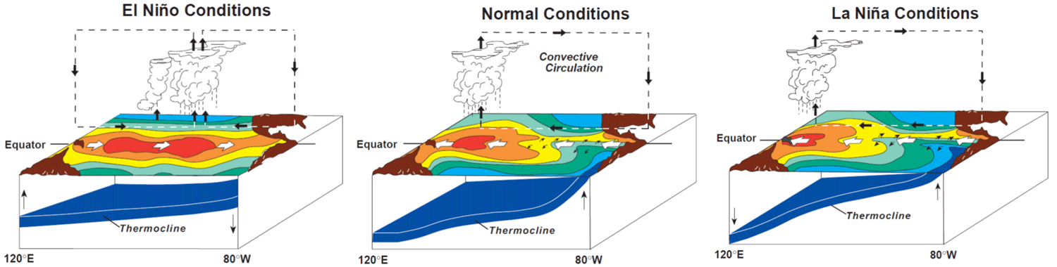
Where does the ENSO phenomenon occur
equatorial Pacific under normal conditions
winds and ocean currents during normal equatorial conditions are moving FROM the ____ coast of ____ ( the ___ Pacific ocean ) TO the ___ coast of ___ ( _____ Pacific ocean )
western coast of south American ( eastern Pacific ocean ) to the eastern coast of Australia ( western Pacific ocean )
Upwelling
what is it? where does it occur? Why does it matter?
upward movement of ocean water, brings cool nutrient rich water to surface.
Occurs far from shore ( equatorial upwelling ) = surface currents move apart and deeper water comes up
coastal upwelling - along steep western coasts of continents = winds blow warm surface water away and cold water comes up
matter because the nutrient affect biodiversity and productive and fish population which supports economy
Central Pacific during normal conditions
trade winds blow east to west
water temp in eastern is cooler and warmer in western pacific
climate is dry in eastern and wet in western pacific
what is link between el nino and disease
el nino drives disease because more precipitation means more disease transmission
brings warm and wet conditions that disease vectors, bacteria, and pathogens thrive in
ENSO ( el nino southern oscillation )
what happens to trade winds
IN western Pacific what happens to climate and water temp
in eastern Pacific what happens to climate and water temperature
equatorial and coastal upwelling
the thermocline becomes
effects(environmental, economic)
trade winds weaken or reverse ( west → east )
dry and cold(western)
warm and wet ( eastern)
upwelling Is suppressed because warm water went towards coast so nothing to replace
thermocline because deeper because warm water being pushed toward shore
effects: decrease in nutrients because no upwelling → not much fish & decrease primary productivity
us gets wet and cool winters
more pacific hurricanes
Under La Nina
trade winds?
climatic and water in western pacific?
climate and water in eastern Pacific?
equatorial and coastal upwelling?
thermocline?
effect ( environmental, economic)?
trade winds are stronger than normal ( E→W)
warmer and wetter in western pacific
dry and cool in eastern pacific
stronger upwelling
thermocline becomes shallower and closer to surface
increase in Atlantic hurricanes
jet stream pushed north → colder winter in Canada and NE US
dryer winters and warmer in SE and SW US
Wetter winters in Pacific NW
torrential rainfall in SE asia
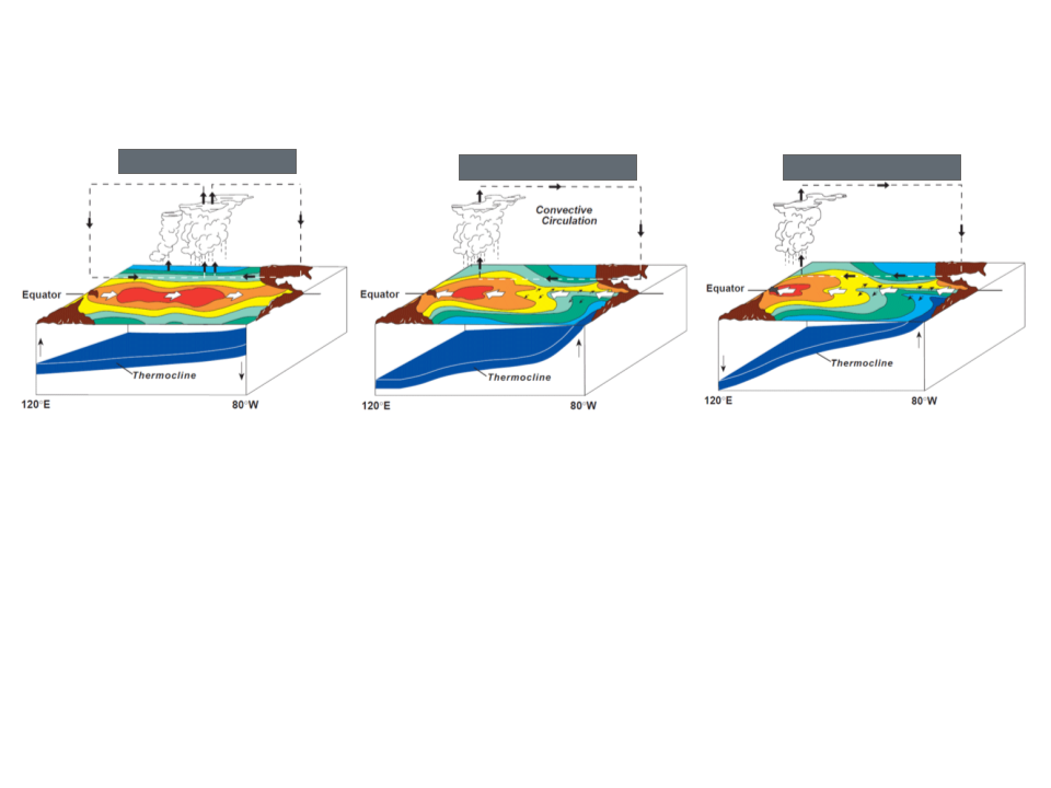
along equator el nino , Nina, normal