GEO 004 FINAL
1/65
There's no tags or description
Looks like no tags are added yet.
Name | Mastery | Learn | Test | Matching | Spaced |
|---|
No study sessions yet.
66 Terms
Watershed
"drainage basin" channels rainfall, snowmelt, and runoff into a common body of water, system of water that all comes together
Discharge
How much water is flowing in a certain amount of time
Sediment load
How much deposit is being claimed by the stream
Braided streams
Has too much sediment load
Straight Stream
Straightest path between two points
Meandering stream
Inner moves slower than the outer current (faster)
What causes floods?
Heavy rain/percipitation, Melting snow, storm surges, dam & Levee failure
Where does flooding naturally occur?
Floodplains, Rivers changing course
Small floods
are more common than large floods
"100 year flood"
1 in 100 chance this flood occurs
Flash floods (and safety)
Localized, Sudden onset of flooding caused by high precipitation (move to high ground)
Regional floods
Long-term high rain or snow melt over large areas/ regions
Catastrophic floods
Lake Missoula (glacier issue)
Floodplains and building location
Significant risk of flooding can cause a lot of damage to homes residing in these areas
Stream channelization
the process of modifying a river or stream's channel to improve drainage, control flooding, and aid navigation
Advantages and disadvantages of channelization
Pros: Allows water to flow easier through the channel, controlling floods. Cons: Too much discharge, erodes bottom banks to try and reach equilibrium
Levees
"box in" a river to keep it on a certain course and keep it from flooding/ human made barrier
Advantages and disadvantages of levee construction
Pros: Temporarily protects for flooding Cons: keep the river in, not from going over, it is depositing itself in the channel and lifting the floodplain higher.
Dams
a barrier that runs across a river or stream to control the flow of water
Urbanization and flood water runoff
Impervious surfaces (roads,buildings) associated with urbanization reduce infiltration and increase surface runoff
How does urbanization change flooding?
Accelerates water run off, increase in flood frequency, make floods worse
Where are mass movements likely to occur?
on steep slopes, particularly in areas with unstable materials, heavy rainfall, or seismic activity
How gravity and friction govern mass movements
The stronger the force of gravity, and the less friction there is, the easier it is for mass movements to happen (friction = up gravity = down = tug o war
(Mass movement section) Effects of water
increases mass (makes it heavier, increases gravity) without increasing friction. It sometimes reduces friction. (liquifaction)
Strength of Geologic Material
Alluvium: Material can be consolidated (well packed and hard, stable) or Material can be unconsolidated (loose, soft).
Firmer/consolidated is more stable.
(Identifiable features of landslides) Head scarp
the steep, nearly vertical surface exposed at the head (top) of a landslide where the slope failed
Creep
is the slow movement of a big chunk of slope downhill.
-By slow, it is on the scale of years.
-Often a result of alternate heating and cooling, or saturation and drying of slope.
Landslide
the sudden movement of rock and soil down a slope (unconsolidated movement)
(Identifiable features of landslides) Head
Highest elevation of the flow
(Identifiable features of landslides) Toe
marks the lower margin of the displaced material in a slide/ end of moving material
Slumps
Rotation of slope material/slides along a curved surface relatively slow
Transitional slides
material slides a long distance as a coherent unit or chunk
Rock falls
the sudden, rapid movement of rock or debris down a steep slope or cliff, often involving free fall, bouncing, or rolling
Debris flow
consists of mud, rocks, wood, or other materials flowing downhill
Mudflow
a rapid movement of a large mass of mud
- an example would be wet loose snow (mud). For debris flow, it would be the powder of the snow.
Subsidence
roof collapse dominantly downward/vertical. the shore is often thrown down due to the earthquake and stays there.
-a slope is not needed; it generates its own slope as it collapses.
-move as separate blocks.
Mitigation Efforts: Building practices ( for Mass movements)
-avoid construction or typing on unelevated or potential high risk erosion land.
-containing and steering: build a check dam or armored channels.
-try to contain it where it might be best detained in one area.
-process always includes cut-and-fill, grading, evacate it, and the three way method.
-three way method: unload the head, strengthen the body, and support the toe.
Retaining walls
rigid structures that comprising of footings and a drainage system in order to retain the soils between two different elevations - a structure that is necessary to hold (in place) mass earth, preventing it from moving downhill.
Channel or Direct flows
landslide that involves movement of material down on a slope in the form of fluid, often leaving behind distinctive upside-funnel shaped deposit. these flows contain debris, mud, and rocks (rock avalanches).
Slope armoring, slope protection (shotcrete, etc.)
slope armoring - known as riprap, that contains large robust boulders or rocks placed along the coastlines, riverbanks, and or other areas susceptible to erosion.
-install bolts to rocks so it does not rotate and takes mass off the system.
slope protection - vegetation, such as grasses and deep-rooted plants, is used to contain water and retain soil.
-retaining walls (wire mesh containers filled with rocks) or soil reinforcement mats to hold back soil and prevent movement.
-drainage of water is another alternative to prevent slumps (divert or move excess water from slopes as water saturation causes stability)
shortcrete - spray concrete on the slope.
Catch fences
slope is a pile of boulders which means boulders are coming down and by definition are not stable. THAT MEANS - robust barriers are strategically deployed to intercept and contain rockfall, preventing its unbridled descent and minimizing the potential for damage.
Reducing slope steepness (slope grading, cut-and-fill)
cut-and-fill: cut sections of roadway or rail areas where the roadway has a lower elevation than the surrounding terrain. Fill sections are elevation sections of a roadway or trackbed.
-cut and fill takes material from cut evacations and uses it to make fill sections.
slope grading: the reshaping of surface ground to a specific, planned elevation or slope to improve drainage, stability, and or construction purposes.
Controlling drainage
Management of surface and subsurface water flow in order to prevent erosion, flooding, and mass wasting events like landslides.
-controls the outlet elevation.
Coastal Erosion
-accelerated by sea wall construction.
-loss or displacement of sand, can be long term removal of sediment and rocks along the coastline due to the action of waves, currents, tides or storms.
Wind-driven Waves
Tsunamis typically have long periods and long wavelengths relative to wind-blown waves.
Wind-driven waves are generated by the friction between wind and surface of the water. as the wind blows, there will be a continual disturbance creates a wave crest.
Wave characteristics (wavelength, amplitude)
-tsunamis typical have longer wavelengths and longer periods relative to wind-driven waves.
-most waves are caused by winds blowing over the surface of water.
-the speed of waves - speed running through water may be faster than the wave itself coming towards you (measured in meters per second).
Wave orbitals and deep vs. shallow water waves
Wave Orbitals and Deep
-faster
Shallow wave waters
-slower
Bend around and travel towards shallow water --> wrap around islands.
Sediment Transport
movement of solid particles (sediment) by a fluid, such as water, wind, ice, or gravity.
-due to a combination of gravity acting on the sediment, and the movement of the fluid in which the sediment is entrained (dragged along).
Summer vs. winter beach profile; why are they different?
Winter beaches have less sand, but it returns back during the Summer.
Winter
-Southern Hemisphere is tilted towards the Sun and north polar region gets very cold.
-increased temperature contrasts between the North Pole and the equator causes winds to blow faster and stronger.
-winter storms are more energetic, and the ocean waves are taller and spread farther apart.
-less sand; high risks of erosion.
-larger breakers rush onto the beach, erode the sand, and carry it seaward with backwash.
-long wavelengths drags the sand offshore to sit in submarine bars until the short wavelengths push it back.
Summer
-Northern Hemisphere during the summer is tilted towards the Sun.
-North Pacific and Atlantic Oceans are relatively calm.
-reduced temperatures contrasts between north polar region and the equator - low wind speeds produce ocean waves of shorter wavelength and height.
-summer waves are smaller, but abundant.
-the numerous waves separated by short wavelengths are bulldozers that push the offshore and build more sandy beaches.
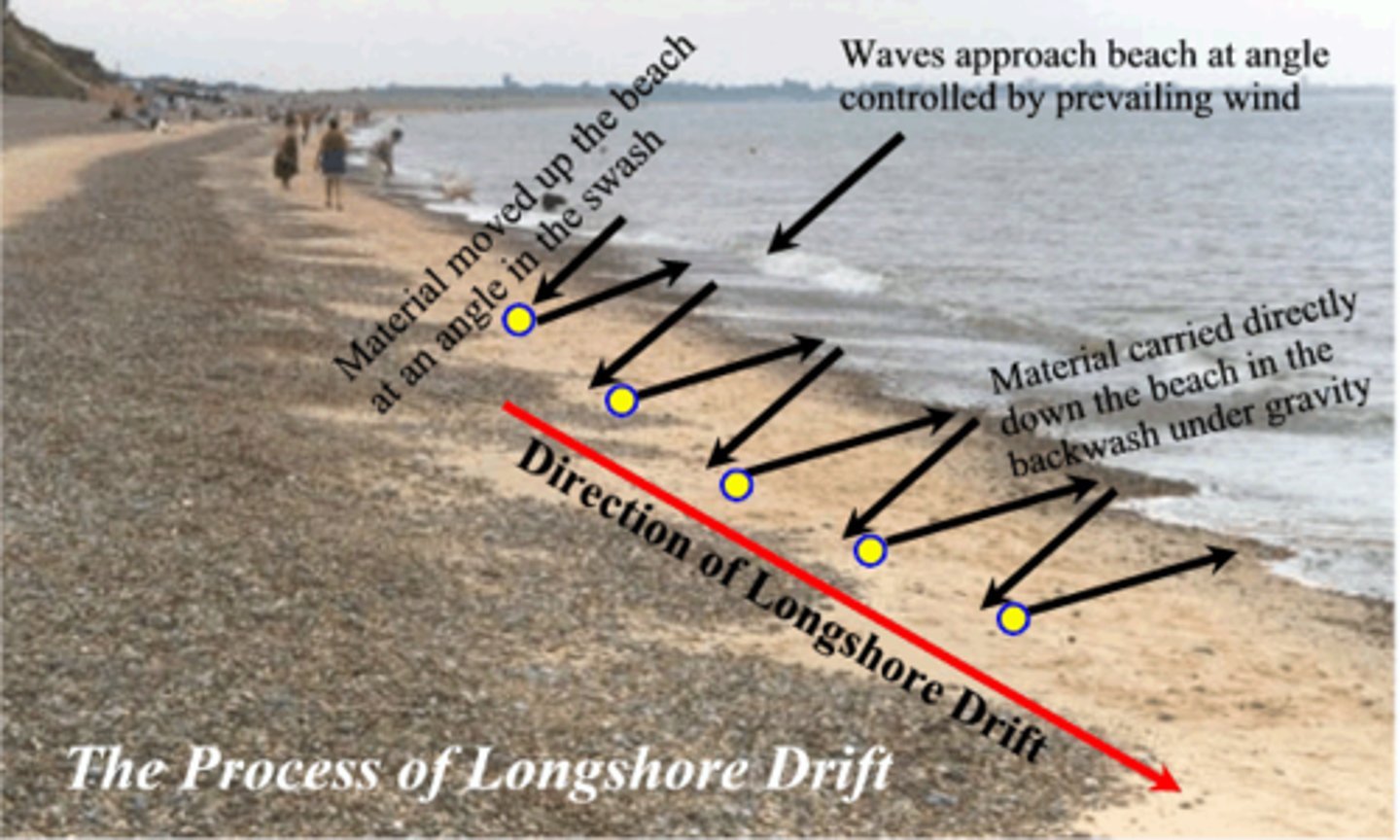
Longshore transport and longshore drift
Longshore transport is the transportation of sand. Longshore drift is when beach sand flows analogous to a river, the riverbanks are the offshore edge to the breaker zone and the upper limit of water run-up (swash) on the beach.
how do human-made structures alter natural sand supply
Human invention like the sea wall prevents the natural process of the beach. Beaches need to be flattened by tall ocean waves, spreading water over a broad area analogous to a stream overflowing its banks. With the blockade, there is nowhere for the ocean's wave energy to be let out on. Sand erosion is bound to happen even if more sand is added.
Seawallsi. Starve sediment supply
sea walls are parallel to shore.
-every action has a reaction.
problems:
-a natural beach is flattened by tall ocean waves, spreading water over a broad area analogous to a stream overflowing its banks - seawalls DISTURBS it.
-ocean wave energy is bounced from the wall and there is less sand to absorb. Thus, eroding the beach and steepening the offshore sea bottom.
-now-deeper water allows waves to attack it.
-seawall and the building it protect will then stick farther into the sea each year as a wave striking around the ends of the wall farther landward.
Breakwaters
built to protect shoreline or harbors from wave attack.
-slows down or stops waves completely.
-may be attached or detached from the shoreline.
-when water is slower, it drops its sediment load and less erosion in the wave protected zone.
-in the sand drift, there will be less sand.
-when pulled back from shore, it is pulled straight back but at diagonal.
-problems: prevents waves from hitting the shoreline, which also cuts off energy that drives from longshore-transport system. sand, deprived of the energy moves it, just stops its travels and fills in the area behind the breakwater.
Jetties
Built perpendicular to the coastline to create inlets to harbors and channels for boat passage.
-trick is to design jetties of the right length to create a large enough tidal prism to naturally scour the channel and keep it open.
-extend beyond barriers extend beyond the breaker zone and interfere with long-transport-system.
-beach sand builds up in large volumes on the up-drift side, while significant erosion occurs down-drift side.
Groins
short, artificial walls built perpendicular to the shoreline to trap sand moved by longshore currents.
-it causes sand to be deposited on the up-drift, however erosion takes place on the down-drift side.
-Emplacement of these USUALLY must be accompanied by artificial replenishment of sands
-the problem with groins is the following: it includes the erosion of sand by storms coming from other directions and their tendency to direct rip currents offshore, carrying sand (and swimmers) beyond the breaker zone and thus out of the longshore drift system.
Beach Replenishment
replacement of lost sand by purchasing and dumping more of it onto beaches.
-problems each beach will have its own equilibrium, and the longshore flow may deposit the sand somewhere else. sand doesn't stay forever. it may help reduce the risks but will not prevent all future beach erosions.
Tsunami vs. wind-driven waves
Tsunami
- exactly or over 30 minutes
-800 kilometers
-20-70 meters on shore (-1 meters in deep water)
-200 meters per second (400 miles per hour)
Wind-Driven Waves
-Period (the time between waves hitting you in seconds) 30 seconds.
-Wavelength is 150 meters
-Height is 2 meters.
-Speed is 15 m/s (meters per second) and 30 miles.
Tsunami generation
the vertical uplift or down throw of water.
Faults (in context of tsunamis)
Tsunamis are caused by vertical motion of water or thrust/reverse faults.
Movement of the seafloor
Tsunamis ALWAYS "feel" the ocean floor. Tsunamis speed up and slow down depending on the depth of the sea floor.
Where do the biggest tsunami occur?
mega thrust faults in subduction zones produce the biggest earthquake and move the water vertically.
mega thrust it takes in between 10-15 minutes between shaking and tsunami arrival.
Volcanic eruption and collapse
An explosion underwater will cause the water to rush up high and create a hole where the water is sucked in.
Caldera Collapse is the downward motion that causes a tsunami.
Mass movements
Mass movements can also cause tsunamis. A tsunami in Alaska was caused by a mass landslide.
Aquatic mass movements - earthquakes may not cause the tsunami itself - it will cause a mass movement or landslide that can generate a tsunami.
Characteristics of tsunami as they propagate through the ocean: Size in open ocean vs. near shore - height and wavelength
Open Ocean
-the height of the wave is small.
-long wavelength.
Near Shore
-as they approach the coastline, the energy of the tsunami increases as well as the height.
-short wavelength.
-Tsunamis usually "break" well offshore: not clean wave when it hits shore and amplified in bays and harbors.
-waves can reverberate and bounce around along the shore.
-the shore is a distance away from seashore uplift and thus the tsunami must travel a bit to hit shore.
Tsunami detection and warning
sea surface buoys and ocean bottom pressure sensors only.
- sea surface buoys: a floating object or can be anchored to monitor the global ocean.
-there are several types of different buoys, but sea surface buoys can be used to aid to navigation and pilots to identify the position of a maritime channel, hazard, or administrative to allow boats, ships, and sea planes.
Areas of highest risk
Subduction zones, Local scales (harbors, bays)