APES - 4.4, 4.5, 4.7 Earth's Atmosphere, Global Wind Patterns, Solar Radiation, and Earth's Seasons
1/49
Earn XP
Description and Tags
Core Content Recall for APES 4.4, 4.5, and 4.7 is based on the content covered in Mr. Smedes' Video Notes and Module 22 from Friedland & Relyea 4e. This aligns with the 2025 Course and Exam Description. The cards are organized in the same order as the instructions in AP Environmental Science courses, with the sequence being 4.4, 4.7, and then 4.5. 4.4 Earth's Atmosphere 4.7 Solar Radiation & Earth's Seasons 4.5 Global Wind Patterns
Name | Mastery | Learn | Test | Matching | Spaced | Call with Kai | Chat |
|---|
No analytics yet
Send a link to your students to track their progress
50 Terms
(4.4) Relative Abundance of Each Gas in the Atmosphere
Nitrogen: ~78%,
Argon: ~0.93%,
Carbon Dioxide: ~0.04%,
Oxygen: ~21%,
Water Vapor: ~0-4% (depdendent on region)
*Combined, Nitrogen and Oxygen compose 99% of Earth's Atmospheric Gasses
(4.4) Relative Abundance of Nitrogen (N) in Earth's Atmosphere
Nitrogen: ~78%
Mostly in form of N₂, unusable to plants without being fixed by bacteria/other action.
(4.4) Relative Abundance of Argon (Ar) in Earth's Atmosphere
Argon: ~0.93%
Noble gas, nonreactive
(4.4) Relative Abundance of Carbon Dioxide (CO₂) in Earth's Atmosphere
Carbon Dioxide: ~0.04%
Most critical Greenhouse Gas—leading to Global Warming Traps heat on Earth, increasing the temperature of the atmosphere. Removed from the atmosphere via Photosynthesis.
(4.4) Relative Abundance of Oxygen (O) in Earth's Atmosphere
Oxygen: ~21%
Produced by photosynthesis, required for cellular respiration
(4.4) Relative Abundance of Water Vapor in Earth's Atmosphere
Water Vapor: ~0-4%
- Varies by region and environmental conditions
- Acts as a temporary Greenhouse Gas, but less drastic/concerning than Carbon Dioxide
- Quickly cycles through the atmosphere
(4.4) Order of Atmospheric Layers (from Earth to Space)
1) Troposphere
2) Stratosphere
3) Mesosphere
4) Thermosphere
5) Exosphere
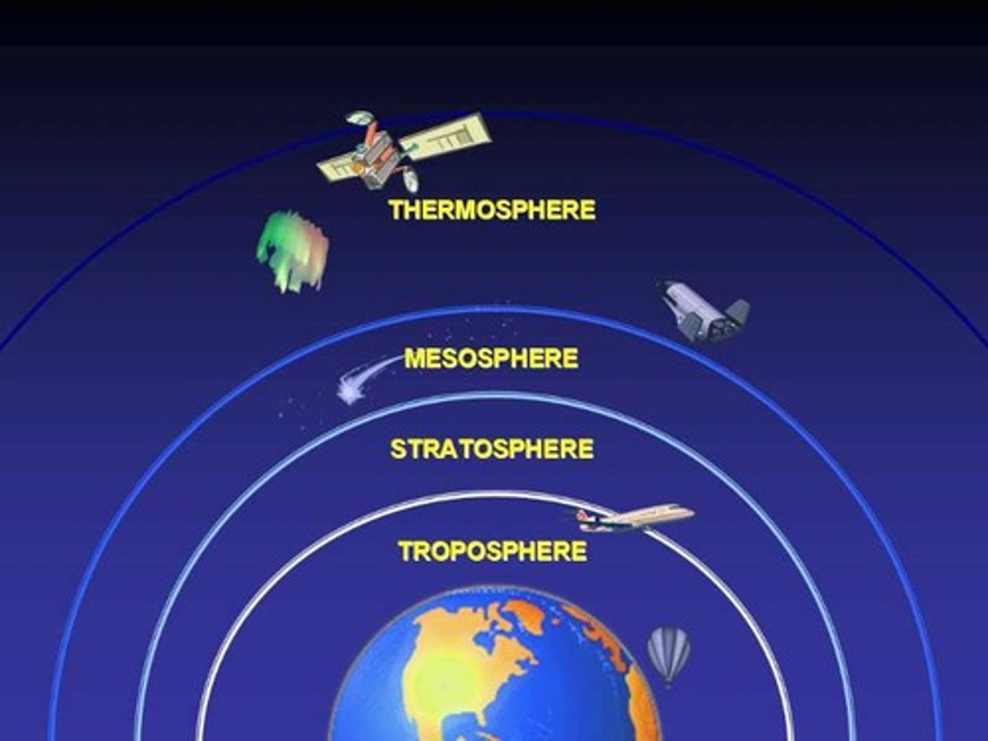
(4.4) Atmospheric Layer: Troposphere
The first layer of the atmosphere, most dense due to pressure of the other atmospheric layers. Weather happens here. It is very cold since as temperature decreases with altitude since air expands as pressure drops
THINK: First, cold!
(4.4) Impact of Ozone in the Troposphere
Harmful.
Humans ➡️ acts as a respiratory irritant
Plants ➡️ damages plant stomata
Environment ➡️ forms smog
(4.4) Atmospheric Layer: Stratosphere
The second layer of the atmosphere, less dense compared to Troposphere, but incredibly warm, due to UV rays warming top layer of stratosphere as they are blocked by the Ozone Layer.
THINK: "S" for 2nd, warm!
(4.4) Atmospheric Layer: Mesosphere
The third or "middle" layer of the atmosphere, it less dense compared to previous layers, but incredibly cold, being the coldest place on Earth as few molecules are able to absorb UV heat at this density.
THINK: Meso or "M" for Middle/3rd, COLD!!!
(4.4) Atmospheric Layer: Thermosphere
The hottest layer of the atmosphere, less dense compared to previous layers, but the hottest place on Earth due to high amounts of solar radiation.
THINK: Therm for HOTTEST TEMP/Heat, HOT!!!
(4.4) Atmospheric Layer: Exosphere
The outermost layer of the atmosphere, less dense compared to previous layers.
(4.4) Trends in Atmospheric Temperature Gradient
The temperature cycles between cold and hot as we go through the layers of the atmosphere. If you start on land and climb up a mountain, it gets colder as you go up.
(1) Troposphere - Cold
(2) Stratosphere - Hot
(3) Mesosphere - COLD
(4) Thermosphere - HOT
(5) Exosphere - HOT
(4.7) Insolation
Incoming amount of solar radiation (the energy from the sun's rays) reaching an area, measured in Watts/m2. It is the primary source of Earth's energy and is dependent on season and latitude.
AKA Incoming Solar Radiation
CED Definition (Paraphrased, from CollegeBoard): "Incoming solar radiation, also known as insolation, is the Earth's primary source of energy, and its amount depends on the season and latitude."
(4.7) Latitude
Distance from Equator, measured in degrees, increase in latitude as you move away
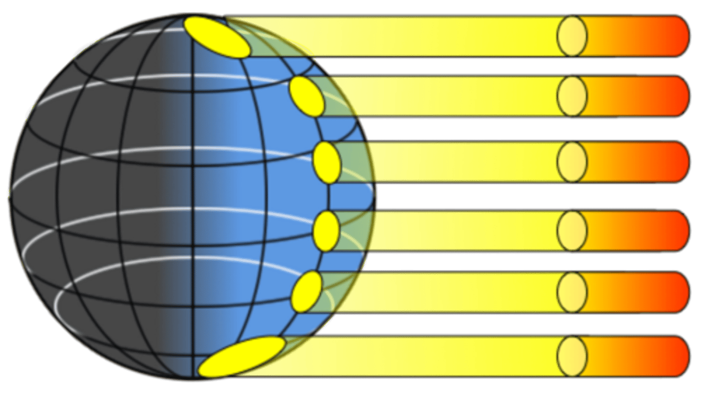
(4.7) Significance of the Equator in the context of how the Sun's energy affects Earth's surface
Higher insolation than higher latitudes Sunlight strikes Earth at a perpendicular angle due to the curvature of the Earth
(4.7) MAKE A CLAIM (ACCURATE) & JUSTIFY YOUR REASONING, responding to the following prompt: Does the intensity of isolation across the planet's surface occurs evenly. Why or why not?
Your claim must be of factual accuracy.
No, it does not occur evenly--resulting in uneven warming patterns. 3 primary causes cause this uneven warming pattern:
(a) Variation in the Angle at which the Sun's rays strike Earth, impacting the amount of atmosphere the incoming solar radiation passes through.
(b) Amount of Surface Area over which the Sun's rays are distributed.
(c) Albedo--some areas of Earth reflect more solar energy than others.
(4.7) Intensity of Insolation: Variation in the Angle at which the Sun's rays strike Earth
At the equator, sunlight hits the Earth at a direct angle, traveling a relatively short distance through the atmosphere to reach the surface in the tropics.
In mid-latitude and polar regions, the Sun strikes at a more slanted angle, traveling a longer distance through the atmosphere to reach the surface near the poles.
Keep in mind that solar energy is lost as it passes through the atmosphere, so more solar energy reaches the equator than the mid-latitude and polar regions.
THINK:
As the sun's rays hit Earth closer to a 90 angle, there will be more isolation due to there being less atmospheric distance to travel through, resulting in intensive concentration and distribution. As the sun's rays hit Earth at a greater angle than 90, there will be decreased insolation due to an increase in atmospheric distance, resulting in less intensive concentration and distribution.
(4.7) Intensity of Insolation: Variation in Surface Area amount over which Sun's rays are distributed
(a) Solar Energy is LOST as it passes through the Atmosphere, directly affecting insolation intensity.
(b) The Equator ➡️ Intensive Insolation due to perpendicular angle of insolation and less atmospheric distance to travel through
(b) Mid-Latitude/Polar Regions ➡️ Less intensive insolation (compared to Equator) due to oblique/obtuse angle of insolation and increased atmospheric distance to travel through.
(4.7) Intensity of Insolation: Albedo
The percentage of insolation (incoming sunlight) reflected from a surface, directly affecting temperature.
Albedo and Temperature have an INVERSE relationship.
⬆️ Albedo = ⬇️ Temperature
THINK:
(a) Surfaces with ⬆️ Albedo REFLECT MORE insolation/light and ABSORB LESS insolation/heat, DECREASING Temperature.
(b) The INVERSE is also true.
(4.7) Albedo: Urban Heat Island Phenomenon
Urban areas are hotter than the surrounding rural areas due to the low Albedo of blacktop/black surfaces, meaning they absorb a lot of the incoming solar radiation, causing them to release a lot of infrared radiation.
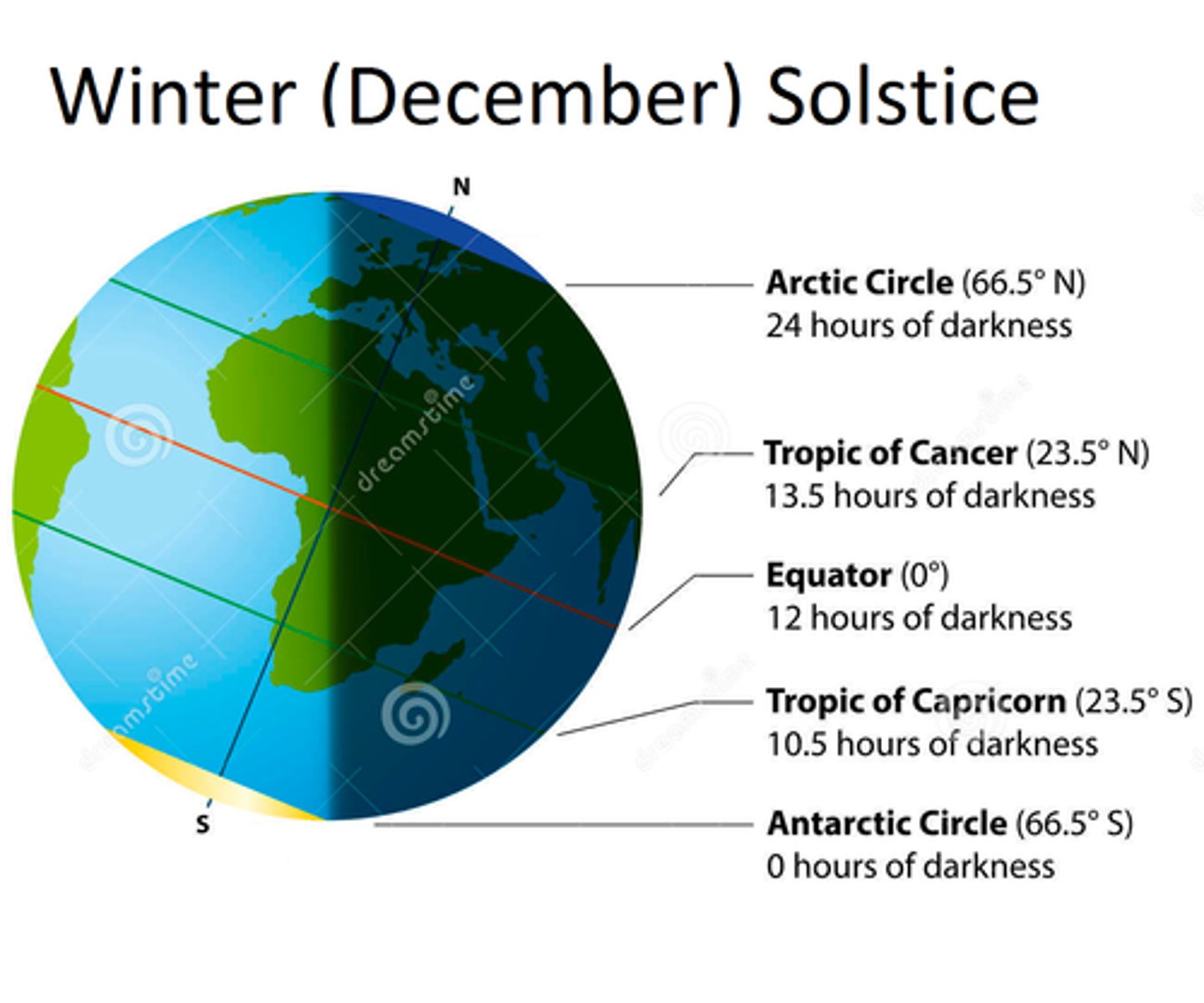
(4.7) IDENTIFY the cause of seasons.
Order of Earth around the Sun & tilt on axis changes the ANGLE of SUN's RAYS, causong varying insolation, varying day length, and seasons.
CED Definition (Paraphrased, from CollegeBoard): "Earth's axis of rotation is tilted, which causes the Earth's seasons and the number of daylight hours in a specific location."
THINK: Order of Earth around the Sun & Axis Tilt ➡️ Change in Angle of Sun's Rays ➡️ Varying Insolation, Varying Length of Day, and Varying Seasons
(4.7) Equinox vs. Solstice
Equinox ➡️ All regions of Earth (Northern & Southern Hemisphere) except those nearest to the poles recieve 12 hrs of Daylight and 12 hrs of Darkness--EQUAL TIME!
Solstice ➡️ One hemisphere experiences more daylight hours than the other
THINK:
EQUinox = EQUAL
Solstice = One hemisphere has more daylight hours
(4.7) December Solstice
The Northern hemisphere is maximally tilted AWAY from the Sun, experiencing the shortest days of the year--initiating the Winter season. Around this time, it's the start of summer in the Southern Hemisphere
THINK:
DECEMBER SOLSTICE
(a) North Hemisphere ➡️ Less sunlight, start of Winter
(b) South Hemisphere ➡️ Increased sunlight, start of Summer
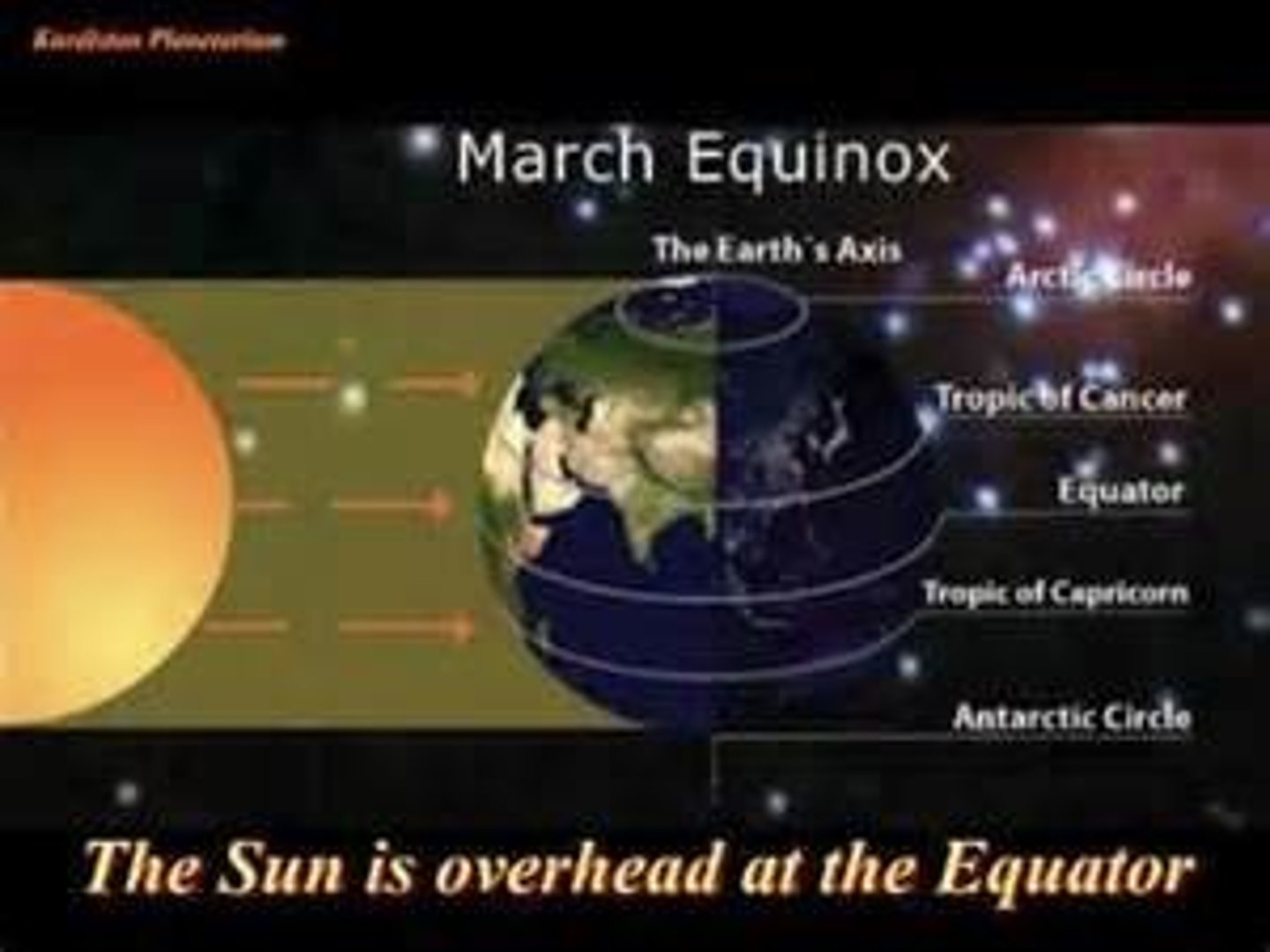
(4.7) March Equinox
At the Equator, the Sun is directly overhead, and all regions of the Earth receive the same amount of daylight - 12 hours.
THINK:
MARCH EQUINOX
(a) North Hemisphere ➡️ 12hr daylight, start of Spring
(b) South Hemisphere ➡️ 12hr daylight, start of Autumn
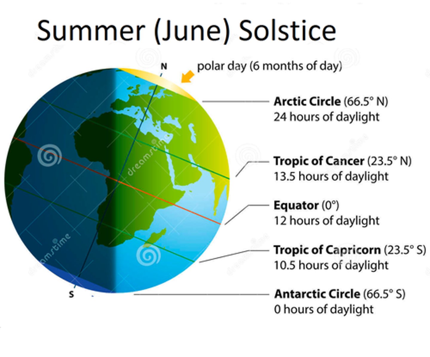
(4.7) June Solstice
The Northern hemisphere is maximally tilted TOWARD the Sun, experiencing the longest days of the year--initiating the Summer season. Around this time, it's the start of winter in the Southern Hemisphere
THINK:
JUNE SOLSTICE
(a) North Hemisphere ➡️ More sunlight, start of Summer
(b) South Hemisphere ➡️ Less sunlight, start of Winter
(4.7) September Equinox
At the Equator, the Sun is directly overhead, and all regions of the Earth receive the same amount of daylight - 12 hours.
THINK:
MARCH EQUINOX
(a) North Hemisphere ➡️ 12hr daylight, start of Autumn
(b) South Hemisphere ➡️ 12hr daylight, start of Spring
(4.7) Trick for Remembering the Equinoxes/Solstices
Start with December, add 3 months, you get March, add 3 months, you get June, add 3 months, you get September. Use your timing of the seasons that you are well aware of.
(4.5) IDENTIFY the location where insolation is the most direct.
The location where insolation is the most direct is the Equator.
(4.5) IDENTIFY the 4 properties of air that determine how it circulates in the atmosphere
Density, Water Vapor Capacity/Moisture Capacity, Adiabatic Heating/Cooling, Latent Heat Release
(4.5) Property of Air: Air Density
Mass of all molecules in the air in a given volume; determines the movement of Air.
Warm air rises because it is less dense.
Cold air sinks because it is more dense.
IRL Insight: The upstairs is always hotter than the downstairs because warm air rises.
(4.5) Property of Air: Water Vapor Capacity
Warm air has a higher water vapor capacity than cold air, leading warm air to also have more moisture compared to cold air.
In regions with high precipitation, hot summer days are associated with high humidity as the warm air contains a lot of water vapor.
(4.5) Saturation Point
Maximum amount of Water Vapor in the Air at a given temperature.
When the temperature of the air decreases, the saturation point also decreases, causing the water vapor to condense into precipitation and forming clouds.
(4.5) Property of Air: Adiabatic Cooling
The cooling effect of reduced pressure on air as it rises higher in the atmosphere and expands.
(4.5) Relationship between Air and Pressure
INVERSE Relationship.
As air rises higher in the atmosphere, the pressure on it decreases. This allows the air to expand in volume, with the expansion lowering the temperature of the air, leading the air to experience adiabatic cooling.
(4.5) Property of Air: Adiabatic Heating
The heating effect of increased pressure on air as it sinks toward the surface of Earth and decreases in volume, condensing and increasing density.
(4.5) Property of Air: Latent Heat Release
The release of energy occurs when atmospheric water vapor condenses into liquid water. This energy is released in the form of heat, going hand in hand with Adiabatic Heating.
(4.5) IDENTIFY the flow of Air.
Air flows from areas of HIGH pressure to areas of LOW pressure.
THINK: Flow of Air - High → Low
*Connection across AP Sciences: Air flows from High Pressure to Low Pressure. AP Biology: Water potential flows from areas of HIGH Water Potential to areas of LOW water potential.
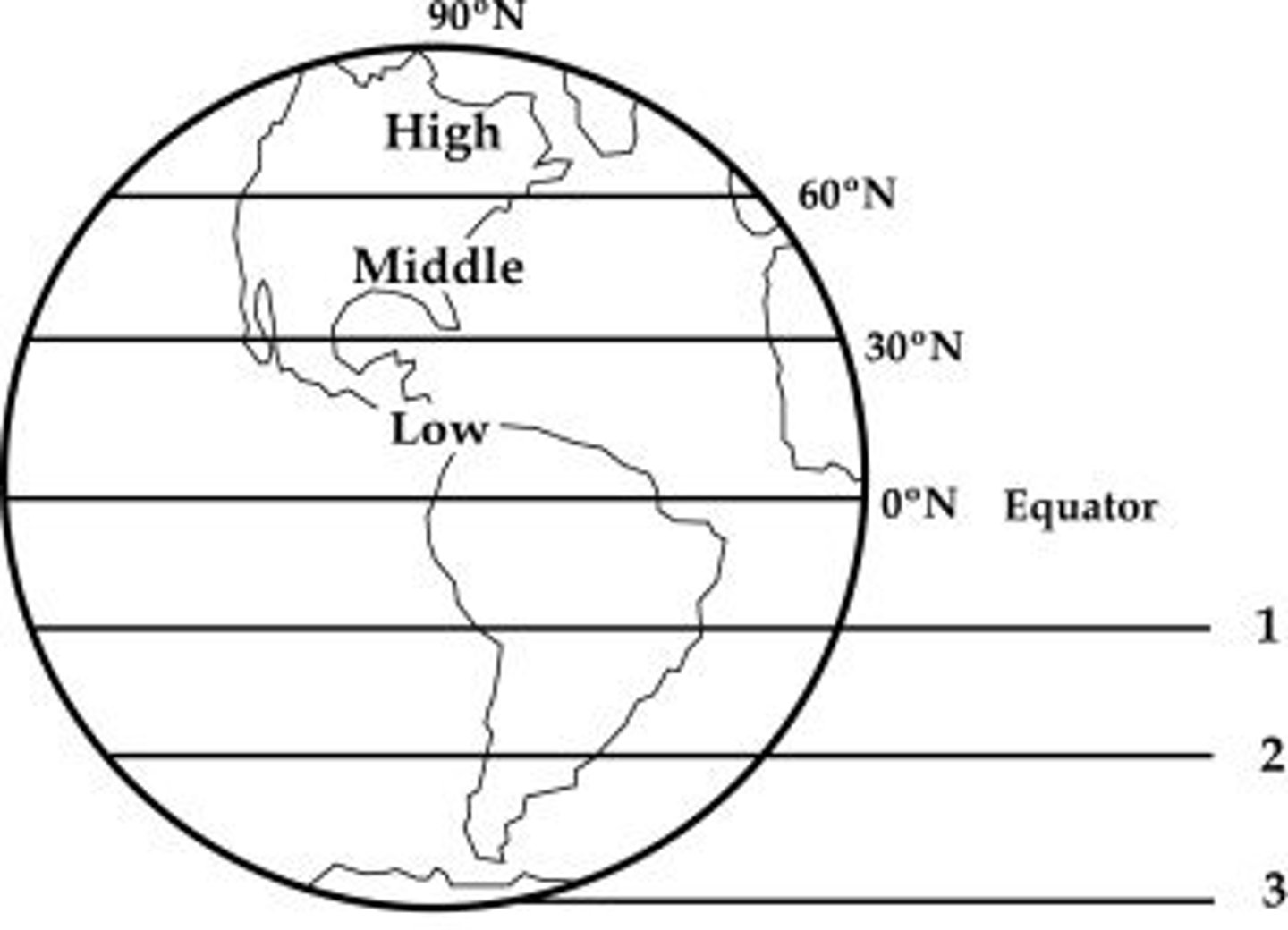
(4.5) Hadley Cell
A convection current in the atmosphere that cycles between the equator and 30N and 30S.
(4.5) Hadley Cell Formation
1) Warm air rises, due to its less density compared to cold air.
2) Warm air experiences adiabatic cooling as it rises, expands, and then cools.
3) Adiabatic cooling results in the formation of precipitation and clouds, along with the release of latent heat.
4) Due to the latent heat release, the warm air will continue adiabatic cooling, rising, expanding, and then cooling until it reaches the top of the troposphere.
5) The warm air is now converted into cold air, being dry, lacking water vapor, and being more dense, sinking down back to Earth's surface.
6) The cool air expierences adiabatic heating, warming the air up as it gets closer to Earth's surface, renewing the cycle.
THINK: Rises (less dense) → expands & cools → dew point → condensation (clouds; sometimes rain) → keeps rising until it loses buoyancy → sinks and warms → repeat.
(4.5) ITCZ
ITCZ → Intertropical Continental Zone.
The latitude that receives the most intense sunlight, which causes the ascending branches of the 2 Hadley cells to converge.
(4.5) Atmospheric Convection Current
Global patterns of air movement initatied by unequal heating of Earth.
(4.5) Polar Cell
A convection current in the atmosphere, formed by air that rises at 60 N and 60 S and sinks at the poles, 90 N and 90 S.
(4.5) Ferrell Cell
A convection current in the atmosphere that lies between Hadley Cells and Polar Cells.
(4.5) The Coriolis Effect
The deflection of an object's path due to the rotation of the Earth.
(4.5) IDENTIFY the direction wind blows from 0°-30°; 30°-60°; 60°-90°.
0°-30° is East → West (Eastern Trade)
30°-60° is West → East (Westerlies)
60°-90° is East → West (Polar Easterlies)
(4.5) Westerlies
Flow of air from 30°-60° is West → East (Westerlies).
Drives weather patterns of North America
(4.5) Easterlies/Eastern Trade Winds
Flow of Air from 0°-30° is East → West (Eastern Trade).
Drives ocean current clockwise in the Northern hemisphere, counterclockwise in the Southern hemisphere.
(4.5) EXPLAIN why deserts form predictably at 30° N/S latitude.
Deserts form predictably at 30° northern or southern latitude since Hadley cell formation occurs, in which the air rises at the equator and returns dry and sinks at 30°, resulting in high pressure, a lack of moisture, and little precipitation.