GIS exam
 Call Kai
 Learn
Learn Practice Test
 Spaced Repetition
 Match
Match Flashcards
 Knowt Play
1/55

There's no tags or description
Looks like no tags are added yet.
Name | Mastery | Learn | Test | Matching | Spaced | Call with Kai | Chat |
|---|
No analytics yet
Send a link to your students to track their progress
56 Terms
Geospatial Technology Matching: GIS:
Software/hardware/data system to capture, store, analyze spatial data.
Geospatial Technology Matching: Remote Sensing:
Capturing/processing data from afar
Geospatial Technology Matching:UAVs
Drones for imagery/LiDAR
Geospatial Technology Matching:LiDAR:
Laser pulses creating dense point clouds
Geospatial Technology Matching:Augmented Reality:
Overlays spatial data on displays
Geospatial Technology Matching:GPS/GNSS:
Satellite location collection.
Which type of Geospatial Technology would this be?
Creating a land cover map by classifying satellite imagery
Remote Sensing (classifying satellite imagery to create land cover maps).
3 examples of GIS / Mapping Platforms Definition:
Google Earth Engine, ArcGIS Pro, and QGIS.
Five GIS Capabilities Definition:
1. Capture
2. Store (geodatabases/shapefiles),
3. Query (finding counties with population > 1 million),
4. Analyze (flood risk modeling),
5. Display and Share (interactive web maps).
Five GIS Capabilities: Display and share
Creating an interactive web map
Origin Decade of GIS
1960s
Which spatial format is a container for vector and raster data, tables, and properties?
Geodatabase (container for vector and raster data, tables, and properties).
Shapefile File Components Definition:
SHP, SHX, DBF, PRJ, and XML.
Vector File Formats Definition:
KML, GeoJSON, SHP, and GDB Feature Class.
Raster File Formats Definition:
TIF, IMG, JPG, and MrSID.
Spatial data allow us to:
To identify and visualize patterns and variation.
Which of the following correctly describes the relationship between the data model and its attribute table?
Raster data has one row in the table for each cell value. Vector data has one row in the table for each feature on the map.
Five GIS Capabilities: Query
Identifying which counties have more than 1 million people
Five GIS Capabilities:Store
Vector and raster layers in geodatabases and shapefiles
Five GIS Capabilities:Analyze
Identifying areas at highest risk for flooding and debris flows after a fire
Five GIS Capabilities:Capture
Collecting field data with a GPS
True or False: It's ok to go back and forth between vector and raster because the data will not change at all in the conversion.
False
Which of the following are advantages of raster data? Select the 3 correct answers.
-Raster has a simple data structure making it easier to perform overlays
-Raster has more analysis choices
-Raster is typically faster to process
What are the three basic geometry types for vector data?
Point, line, and polygon
Which data storage model is best for discrete features like trails or pipelines?
Vector
Within an attribute table, each attribute field is stored in its own:
Column
What's the term for a collection of features with the same geometry, attributes, and coordinate system?
Feature class
Shapefile
A spatial file format which stores vector data as a collection of multiple files including a dbf, shx, and more.
Coordinates
Location information stored as a pair of numbers. Points - and vertices for lines and polygons - are made up of these.
Attribute
Information about each feature, stored in a field in a table.
Feature
Individual items or objects, stored in a spatial file. Each one of these has a row in the table with its attributes.
Vector
Data storage model depicting entities as points, lines, and polygons
Feature Class
A collection of features with the same geometry, coordinate system, and table. Commonly referred to as a layer.
Geo JSON
A spatial file format used widely for web-based data. It stores coordinates and simple attribute tags for features.
Grid Cell
The individual component of a raster, stored in an array of rows and columns
What are the two primary data storage models?
vector and raster

This type of attribute table is for a:
raster layer
How do we define "cell size" for rasters?
The length of a grid cell on one side
Which of the following is an advantage to using a Geographic Coordinate System?
It is applicable worldwide
A projection with conformal in the name is attempting to minimize distortion in what category?
shape

The graphic below is showing a(n) _______ _________ type of projection.
cylindrical, oblique
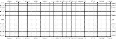
You have a map with a grid-shaped graticule that looks like the following graphic.
cylindrical
What is scale?
The ratio of a distance on the map to a distance on the Earth
At what location in a UTM zone is there no distortion?
Make sure you understand how UTM zones are set up before answering this question
Along one of the secant lines
The Universal Transverse Mercator coordinate system uses a Transverse Mercator projection.
This is an example of what projection family?
Cylindrical
We say that maps lie because of distortion.
What are the four categories in which maps 'lie'?
area
distance
shape
direction
The two general types of coordinate systems are:
projected
geographic
A mathematical approximation of the shape of the Earth is called a(n):
ellipsoid
What type of projection would be ideal for a map of an east-west oriented continent?
A conical projection
What is the UTM Easting coordinate for the center of a UTM zone?
500,000
4,491,359.78N
UTM coordinate for Morgan library representing meters north of the Equator
40.572987
Geographic coordinate in DD
40 30 23.56
Geographic coordinate in DMS
492,847.681715E
UTM coordinate for Morgan Library representing meters East within Zone 13
NAD83 is an example of a:
Datum