CI B K3
 Call Kai
 Learn
Learn Practice Test
 Spaced Repetition
 Match
Match Flashcards
 Knowt Play
1/54

There's no tags or description
Looks like no tags are added yet.
Name | Mastery | Learn | Test | Matching | Spaced | Call with Kai | Chat |
|---|
No analytics yet
Send a link to your students to track their progress
55 Terms
Sustainable and Resilient Development Design
protections and practices employed during the site development process that reduce the environmental impact of a project while retaining and enhancing the owner/developer’s purpose and vision for the site
Sustainability
the support of long-term ecological integrity
Avoiding and minimizing land cover conversion in areas susceptible to erosion
Preserving areas that provide important water quality benefits + habitat features
Developing sites in a manner that protects water bodies and natural drainage systems
Sustainable site design practices
mimic predev hydrologic conditions by preserving natural features and reducing impervious cover
Reduces cost of infrastructure
maintains/increases value of property
Typical elements of sustainable site design
Preserving natural areas and native vegetation
Minimizing disturbance of existing, mature stands of vegetation
Reducing impact on watershed hydrology
Incorporating natural drainage pathways as a framework for site design
Preventing stormwater impacts rather than mitigating for effects
Managing stormwater quantity and quality as close to source as possible
Using simple conservation methods rather than structural controls → lower cost/maintenance
reducing soil compaction during construction
Resiliency
the ability of a system to respond to, or recover readily from, stresses or disruptive forces
New dev should be guided away from known hazards
Need to implement practices in new devs that are resilient, strong, flexible
Primary goal is to design system that can function in the face of threats/hazards
Conserve natural environmental protective systems
Hazard mitigation activities
Planning to identify hazards + vulnerability
Implementing smart growth + hazard mitigation plans before disasters occur
Avoiding known/previously affected vulnerable areas (ex. floodplains)
Also seeks to address identified hazards w/structural/nonstructural approaches
3 types of recs for more sustainable designs
Conservation of natural areas
Appropriate design of streets/parking lots
Ex. reducing street lengths/widths
Appropriate site/lot development plans
Reduces need for clearing/grading, greeater open space, more canopy, opportunities for conservation initiative
Where do nontidal wetlands occur?
floodplains
in MS: bogs, swamps, riverbanks, bottomland forests, bayheads, coastal flatwoods, and savannas
tidal wetlands
found @ edge of coastal waters, provide habitat for birds and a nursery for shrimp + our aquatic life
Salt + brackish marshes, freshwater marshes and swamps, mud flats, tidal open water habitats (bayous, rivers, oyster beds, other coastal waters)
Common trees: bald-cypress, tupelo gum
MDEQ Erosion and Sediment Control Practice
emphasizes the importance of protecting intact wetlands and stream channels, provides further information on the regulatory programs in place for their protection
federal CWA Section 404, Rivers and Harbors act of 1899
U.S. Army Corps of Engineers (USACE) must issue a federal permit for any actions that impact tidal wetlands, nontidal wetlands, and shallow water habitat.
2 types of permits: general + individual
Requires developer to take steps to avoid/minimize wetland impacts caused by implementing a project + provide compensatory mitigation for any remaining unavoidable impacts
Projects requiring Section 404 permit also require section 401 water quality certification from MDEQ
Actions requiring USACE authorization
Construction of piers, marinas, ramps, cable or pipeline crossings
Dredging and excavation in or adjacent to waters of the United States
Fill for residential, commercial, or recreational developments
Construction of revetments, groins, breakwaters, levees, dams, dikes, and weirs
Placement of riprap (for channel stabilization)
National Flood Insurance Program
for coastal counties — Local govs required to restrict placement of any structure, fill, or obstacle within the floodway of a stream or river
Within Mississippi
Development in floodplains regulated by county + city floodplain + dev ordinances
Benefits of riparian buffers
provide filtration for overland flow → retains sediment from up-gradient disturbed areas + after construction
flood control
Helping protect properties from shifting and widening of stream channels that occur over time
Increasing property values
Minimizing activities that degrade, destroy, or reduce the value and function of coastal marshlands
Enhancing scenic value and recreational opportunities of wetlands
Protecting coastal habitat for nesting and feeding wildlife
Protecting important nursery areas for fisheries, which provide food and habitat to numerous species of fish and shellfish, including commercially important species
protect waterways + aquatic resources from short + long term impacts of dev
extend important protection to narrow corridors
provides greater habitat connectivity w/nearby tidal marshes + open waters
Site Assessment
an in-depth evaluation of the eco conditions + natural features present @ the proposed dev/redev site + is conducted prior to developing a detailed site design
Conditions/features to investigate:
Wetlands
Floodplains
Riparian areas, streams, and other waterways
Soil types, infiltration capability, and soil erodibility
Mature forests and other woodlands
Types and health of other existing vegetation (trees, shrubs, grasses, and forbs)
Prominent landforms
Steep slopes
Depression storage
Aquifer recharge areas
Green infrastructure
managing stormwater close to its source and using nonstructural methods for stormwater management
uses vegetation + soils to manage stormwater via infiltration, evaporation/transpiration , and rainwater capture and reuse
Gray infrastructure
uses built structures such as concrete curb + gutter systems, pipes, and retention basins
Low-impact Development (LID)
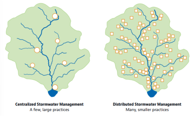
focuses on managing rainfall @ source, using distributed, decentralized small-scale controls on the lot level that mimic natural hydrology
Key elements:
Conservation
Small-scale control
Customized site design
Pollution prevention and education
Directing runoff to natural areas
Result in ~25-30% reduction in costs associated w/site development, stormwater fees, and maintenance for residential developments
EPA Water Quality Scorecard
Help local govs id opportunities to protect water quality by removing barriers + revising/adopting pertinent codes, ordinances, incentives
Offers resources for:
Protecting natural resources + open space
Promoting efficient, compact dev patterns + infill
Designing complete, smart streets that reduce overall imperviousness
Encouraging efficient parking areas
Adopting green infrastructure stormwater management provisions
Conservation design
laying out elements of a dev project to take advantage of a site’s natural features + preserve sensitive areas, while also considering site constraints + opportunities to prevent/reduce enviro impacts
Techniques:
Preserving undisturbed areas
Preserving stream buffers
Reducing clearing and grading
Locating projects in less sensitive areas
Reducing front and side yard setbacks
Aggregating shared open space rather than focusing on individual yards
Clustering built features to minimize the amount of disturbed area
Infiltration Practices
Infiltration basins, trenches, or dry wells
Highly applicable for roadway projects
Design Criteria
Pretreatment upstream (filter strips, grassed swales, concrete sumps, forebays)
Should be designed to completely drain within 72 hrs of the end of a rainfall event
Underlying native soils must have infiltration rate of 0.52 in+
Distance from bottom of infiltration practice to top of water table should be 2 ft+
Observation wells used to monitor percolation + performance of practice
Do not place under pavement/concrete
infiltration practices advantages
Helps restore pre-dev hydrology on dev sites, reduces post-construction stormwater runoff rates + volumes
Provides v high level of removal for all pollutants
Provides for groundwater recharge
Good for small sites w/well-draining soils
Can be integrated into dev plans as landscaping features
infiltration practices disadvantages
Can only be used to manage runoff from relatively small drainage areas of 5 acres or less
Potential for groundwater contamination
High clogging potential, shouldn’t be used on sites w/fine-particle soils in drainage areas
Should not be located where they undermine foundations or negatively affect underground utilities/other infrastructure
Geotechnical testing required, 2 borings per practice
Permeable Pavements
Water infiltrates into crushed stone bed + infiltrates into soil below
If native soils have low permeability, perforated underdrain can be provided to collect water + convey it to downstream conveyance system
3 primary types: permeable pavers, pervious asphalt pavement, pervious concrete pavement
Design Criteria
Subsurface reservoirs to hold runoff volume from 1-inch storm event
Use of underdrain in low permeable soils
Underdrain + liner if infiltration not desired
Terrace subgrade base/use underdrains for slopes >2%
permeable pavements pros/cons
Advantages
Reduced runoff
Improved water + air quality
Reduce heat island effect
Disadvantages
Should not be used in hot spots
Should not be used on high-volume or high-speed roadways
Do not use in areas that may receive high sediment loads
Should not be used where hazardous materials may be loaded, unloaded, or stored
Bioretention Cell
a depression in the ground filled with soil media mixture and planted with vegetation that can tolerate inundation and dry periods
Contain underdrain system allowing filtered stormwater to exit the system
Design Criteria
Drainage area 5 acres or less
Media depth 2-4 ft
The permeability of the filter media should be between 1 and 6 inches per hour, and 1-2 in/hour is preferred
Ponding depth should be 12 inches or less (9 inches is preferred)
Provide an overflow or diversion structure to bypass larger flows around the bioretention cell
Design with an upturned underdrain to provide internal water storage volume and enhanced water quality and infiltration
Advantages/benefits
Removes many diff types of pollutants
Good for small areas w/high impervious cover
Good retrofit capability
Aesthetic feature
Disadvantages
Areas w/steep slopes
Soils may clog over time
Landscaping plan required
Stormwater Planters
container or enclosed feature located above ground or below ground, planted w/vegetation that collects + treats stormwater through layers of mulch, soil, and plant root systems where pollutants such as bacteria, nitrogen, phosphorus, heavy metals, oil, and grease are retained degraded, and absorbed.
Design criteria
Plant w/native vegetation
Captured runoff should drain out in 24 hours
Structural elements of planters should be stone, concrete, or brick
Requires use of underdrain
A maximum ponding depth of 6 in is recommended
stormwater cell pros/cons
Advantages/Benefits
Reduced stormwater runoff volumes, flow rate, and temperature
Treats runoff
Wildlife habitat + aesthetic benefits
Requires limited space
Flexible for use in areas of various shapes + sizes
disadvantages/limitations
Small size limits stormwater quantity/quality benefits
High installation cost
Can only receive runoff from small drainage areas
Grassed Swales
vegetated, open-channel management practices designed specifically to treat + attenuate stormwater runoff for a specified water quality volume
Designed w/filter bed that may overlay underdrain system
Design Criteria
Treats runoff for small drainage areas of <5 acres
Should be used on slopes <4% (1-2% recommended)
Provide storage volume equal to runoff volume from 1st 1-in rainfall
Small forebay/pea gravel diaphragm needed for pretreatment wheere water enters swale
Min 2 ft clearance between swale bottom + groundwater
Advantages/benefits
Good for linear eenvironments
Lower cost
Aesthetic benefits
Disadvantages
Design depended on site conditions + topography
Potential for bottom erosion + sediment resuspension
Rain Gardens
shallow depressions planted w/native veg to capture + treat runoff
Can be planted w/groundcover, grass, shrubs, or trees
Design Criteria
Sizing based on drainage area
Infiltration testing required, avoid compacted soils
Plant w/native veg
No underdrain required
Advantages
Reduced runoff
Requires limited space
Aesthetic
Disadvantages
Small
Vegetated filter strips
grassed surfaces designed to treat sheet flow from adjacent surfaces
Often used for pretreatment
Design Criteria
At least 25 ft long
Pea gravel diagram @ top of slope
Slope btwn 2-6%
Groundwater >2ft deep
Grass should withstand high-velocity flows + both wet + dry periods
Advantages
Good pretreatment for other stormwater practices
Best for treating runoff from roadways, roof downspouts, v small parking lots if sheet flow can be maintained
Low cost alternative
Groundwater recharge
Disadvantages
Concentrated flow within filter strip receivee little to no pollutant removal → must maintain sheet flow
Poor retrofit options b/c of space requirements
Requies periodic maintenance to prevent channelization
Constructed stormwater wetland
Temporarily store stormwater runoff in shallow pools that support emergent + riparian vegetation
Design Criteria
Sufficiently large drainage area/adequate groundwater/surface water supplies to provide year-round hydration (~25 acres)
Upstream slope <15%, local slopes relatively shallow
Elevation drop from inlet to outlet should be at least 3-5 ft
6 components: inlet, deep pool, shallow water, shallow land, upland, outlet
Advantages/benefits
High removal rate for pollutants
Wildlife habitat, aesthetic benefits
Good for areas w/flat terrain + high groundwater
Disadvantages
Requires large land area
Requires continuous baseflow for viable wetland
Difficulties in establishing veg + maintaining permanent pool
Potential escalated mosquito pop
Stormwater Ponds
Constructed basins that have permanent pool of water throughout the year
Water mixes with + dilutes initial runoff from storm events
2 primary configurations of stormwater ponds that achieve 80% TSS removal:
Wet pond: permanent pool volume equal to runoff from 1st in of rain
Wet extended detention pond: smaller permanent pool, temporary storage volume above permanent pool to hold + release runoff over 2 days
Design criteria
Sufficient inflow to maintain permanent pool
Upstream slope should not exceed ~15%, local slopes should be relatively shallow
4 design features: pretreatment, permanent pool, outlet structure, safety features
Depth of permanent pool should not exceed 8 ft
Side slopes to pond should not exceed 3:1 w/o safety precautions
Advantages
Moderate to high removal rate for urban pollutants
High community acceptance
Opportunities for wildlife habitat and aesthetic benefits
Disadvantages
Requires large land area
May pose safety hazards
Potential for thermal impacts/downstream warming
Potential for increased mosquito population
Potential Erosion + Sediment Problems Associated with Land Development
Dev activities expose disturbed soils to raindrops + storm runoff
Negative effects on physical properties of soil, onsite drainage + storm runoff patterns, off-site stream/stream-flow characteristics
Hazards associated w/development:
Increase in developed areas exposed to storm runoff/soil erosion
Increased runoff, accelerated soil erosion + sediment yield + higher peak flows caused by:
Removed veg cover
Exposure of more erodible underlying soil/geo formations
Reduced cap of exposd soil to absorb rainfall b/c of compaction
Enlarged drainage areas b/c of grading oprations, diversions, street construction
Prolonged exposure of unprotected disturbed areas b/c of scheduling problems/delayed construction
Shortened times of concentration of surface runoff from altering slope steepness, length, surface roughness + installation of “improved” storm-drainage facilities
Increased impervious surfaces
Creation of exposures facing south + west that may hinder plant growth b/c of adverse temp + moisture conditions
Exposure of subsurface materials that are rocky, acidic, droughty, or unfavorable to vegetation
Erosion + Sediment Control
Leave existing vegetation that doesn’t need to be disturbed → minimize disturbance
Minimize period of bare ground by shortening construction periods + staging project when possible
Sequence installation for shortened construction periods + permits the use of temporary/permanent seeding when most effective
Use sediment control + turbidity measures that minimize sediment/turbid water from leaving disturbed site
Plan appropriate erosion ctrl for all kinds of erosion that may occur
Install erosion-control plantings
Prevent sediment from leaving construction site during muddy periods
Maintain practices, regular + timely practices
Stormwater Problems Associated w/Land Dev
First flush”: washing action that stormwater has on accumulated pollutants in the watershed
In early stages of a runoff rain-event, land surfaces are flushed clean by stormwater
Creates shock loading of pollutants
Amt of runoff that creates “first flush” depends on activity, site conditions + pollutants
Treatment of first flush → minimized WQ impacts of stormwater
Value of hydrologic environment as an amenity affected by 3 factors:
Stability of stream channel
Accumulation of trash
Disruption of stream community
Channel that is gradually enlarged from increased floods due to urbanization → decreased visual atractivenss, addition of nutrients/organics/sediment, etc
Historic vs current stormwater management
Historically, stormwater management was only designed for safety + convenience
Goal was to remove runoff as quickly as possible
Now, management is much more comprehensive
Objectives: flood ctrl, nonpoint source pollution ctrl, off-site erosion ctrl
Need to ensure volume, rate, timing, and pollutant load of runoff after dev are similar to those that occurred before dev
Use coordinated system of source controls: emphasize prevention/reduction of NPS + excess stormwater flow before it ever reaches a collection system/receiving waters
Flood Control
Historically most common goal of stormwater management
b/c increased stream flooding → prop damage, safety hazards, etc
2 levels of drainage systems must be considered: primary + major
Primary drainage system
Consists of street gutters + ditches, storm sewers, culverts, and open channels that are designed to prevent inconvenience and minor property damages from relatively frequent storm events
Should be planned + designed in advance
But most are implemented on “as needed” basis → capacity becomes inadequate w/upstream dev
Can replace/modify elements of primary drainage system but expensive, doesn’t address problem
Can have new dev required to ctrl runoff from their sites in way that won’t affect downstream drainage system w/stormwater detention criteria
Typical detention criteria
Specify stormwater runoff from new dev must be controlled so that post-dev peak runoff rate doesn’t exceed pre-dev peak rate for some specific frequency design-storm/range of design-storm events (usu 10 yr)
Requiring slower release rates will also req larger storage volumes in detention systems
Major drainage system
Comes into play when cap of primary drainage system is exceded
Consists of floodplains + surface-flow routes that water will follow during major storms
Most effective strategy = ensure stormwater has a route to follow that won’t cause major prop damage/loss of life
Use floodplain ordinances, zoning regulations, or other land-use controls to restrict floodplain dev
NPS control
Goal of controlling NPS is relatively new
Likely highest priority in watersheds that feed public water supplies or recreation reservoirs
In urban areas, mos stormwater detention practices used to ctrl runoff quantity may also be adapted for use as BMPs for NPS
Slightly diff design criteria - goal tto maximize detention time of captured runoff
Basin-drawdown times btwn 30-40 hrs → significant pollutant removal
Off-site Erosion Control
Similar strats to flood control, differs in frequency of storm that must be controlled
Most natural stream channels formed w/bank-full cap to pass runoff from storm within 1.5-2 yr recurrence interval
w/upstream dev, volume + velocity of flow from relatively frequent storms increase → increased flooding
Stream channels often subject to 3-5x increase in frequency of bank-full flows in typical urbanizing watershed
Places stress on channel to adjust shape + alignment to accomodate increased flow
Adjustment usu happens in short tim
vegetated meandering streams become straight, wide, + barren → prop damage, channel degradation
Historically used channel mods to increase carry cap/stabiity of streams
But controversal, requires special permits
Recent innovations based on natual stream-hydrology concepts are becoming more popular
On-site stormwater detention criteria for new dev projects can also be used for more frequent storm events
Multiple-Purpose Criteria
Stormwater can be managed to accomplish all 3 goals simultaneously
Ex. stormwater-detention basin can be designed as multipurpose structure by incorporating diff release rates @ diff stages
Principles of Stormwater Management
First step should be basing land-use planning decisions based on site planning principles
Stormwater-management system for each dev project should be based on/support a plan for entire watershed
Should mimic/use features + functions of natural drainage system
Need to map + id existing natural systems
Use “natural” engineering techniques to maximize enviro/econ benefits
To approximate pre-dev conditions:
Maintain perviousness to greatest extent possible
Rate of runoff shoulld be slowed
Maximize on-site stormwater storage
Runoff should be routed over longer distance for increased infitration/evaporation, allow suspended solids to settle, + remove pollutants before entering water bodies
Stormwater management systeems should be planned in advance of the facilities that will discharge into them
Design beginning w/outlet for the project
Downstream conveyance system should be evaluated to ensure it has sufficient cap for design discharge
Restricted outlet = common problem, causes stormwater to back up → use more than one outlet or increase on-site storage volume
Stormwater should be considered an asset – has potential for irrigation, recreational lakes, groundwater recharge, industrial cooling, etc
Use multiple-use, temporary storage basins when practical
Shorelines should be sinuous → increased space for growth of shoreline veg, providing for greater pollutant filtering + increaseed/diversified aquatic habitat
benefits of vegetative cover
protects soil surface from raindrop impact, scouring overland flow, decreases erosive cap of flowing water by reducing its velocity
Reduced moisture content of soil via transpiration → increased cap to absorb water
Reduced heat reflectance + dust, increase prop value
Need to consider effectiveness for soil stabilization + aesthetics when selecting plants (prioritize natives)
Need grasses/legumes that grow close together to stabilize disturbed sites
Trees for long-term soil + water protection, not for concentrated flow areas
Site Planning for Tree Protection
Tree protection measures should be extended from trunk to edge of dripline to protect roots from compaction
Can also use tree wells?
Construct sediment basins in natural depressions
an imaginary circle on the ground directly beneath the tips of the outermost branches. This perimeter is where the majority of natural rainwater drips off the canopy, and it marks the critical root zone where fine feeder roots absorb most of a tree's water and nutrients
The Stormwater Chain
path of rainwater from highest (rooftops) to lowest point (water body)
Cisterns
large containers that store water (ex. Rain barrels)
Rainwater has less salts (chlorine, fluorides) than tap water → using rainwater prevents salt buildup + burning on salt-sensitive plants
Any material that holds liquids can be used
Avoid transparent containers to prevent algae buildup
Can install first-flush diverter if catching water from downspout or roof – prevents contaminants from first flush from going into tank
Can also bury cisterns in ground + get water via pump
Detention ponds
temp water storage
Protect against flooding + erosion, help settle sediments
Ex. rain gardens, biofilters
Not created to hold large amts of water for extended periods of time
Retention pond
landscape feature that holds water for extended period of time
Ex. ponds, water gardens
Rain Gardens
Should have surface water for only a few days (not long enough for mosquitoes to mature)
Best located in main drainageways on property or in lower depressions
Considerations:
Contact utility company to avoid buried lines/pipes before excavating for garden
Do not place near septic drainage fields
Place downslope from any structure, avoid building foundations
Select areas open/away from large trees
Avoid steep slopes (>12%)
Sandy soils usu best for allowing water to drain into surrounding soil (need to drain at least 1 in/hr)
Biofilters
Similar to rain gardens but linear, constructed deeply to handle more water volume
Good for storing + cleansing water in parking lots or other impermeable paving areas
Microbes break down organic components + release nutrients when water filters through soil
Cleans silt + pollutants from first flush
Dry Swales, Dry Creeks, and Drainageways
Drainage swales designed to be more attractive + carry water safely (compared to roadside ditches)
Dry Swales
Dry for much of the year, only tmep contain water after rain
Shallow drainge areas sized to accomodate max water lvls
Can use turfgrass in sunny areas to stabilize soils
For shady, dry swales:
Swamp red maple
Bald cypress
Green ash
Dwarf palmetto
Chokeberry
Buttonbush
Etc
Green Roofs
Live plants + growing media installed on roof along w/impermeable membranes + drainage
Benefits:
Reduces summer temps by up to 20 degrees
Absorbs rainwater + reduces runoff
Reduces traffic + other urban noises
Additional habitat for birds/animals
Protects roof from sun exposures + temp fluctuations
Additional insulation for building interiors
Usually separation layer directly on rooftop, then layers of insulation, moisture barrier, waterproofing, drainage protection, drainage, filter fabric, growing media, plants
Slope of roof should be 5-20 degrees
Avg nat cost is $8/sq ft
Intensive green roofs
Growing media 8-24 in, allows for inclusion of larger shrubs/trees
Need more regular maintenance, for structuress that can support heavier loads
Extensive green roofs
Shallower (2-7 in)
Herbaceous pants, ground covers
Better for existing roof types b/c lighter
Less maintenance