AP Human Geography Unit 1 MCQ
1/20
There's no tags or description
Looks like no tags are added yet.
Name | Mastery | Learn | Test | Matching | Spaced | Call with Kai |
|---|
No analytics yet
Send a link to your students to track their progress
21 Terms
census data
Which of the following types of information is shown in the table?
Natural resource use should be balanced with the needs of the environment and future generations because many resources are nonrenewable.
Which of the following statements best explains the concept of sustainability?
Even in areas of urban land use, there is a significant relationship between nature and society.
In 1854, London physician Dr. John Snow mapped the spatial relationship between deaths from the waterborne disease cholera and the locations of water pumps which brought in water directly from tunnels connected to the River Thames. From Snow's research it was determined that a public water pump had been contaminated by sewage.
What geographic principle explains the significance of Snow's research?
What area is influenced by a node?
Which of the following questions must be answered in order to identify a functional region?
Ethiopia, Somalia, South Sudan
A nongovernmental organization is planning a new international elementary education program. Based on the map shown, which of the following groups of countries would be the best candidates to receive funding?
It provides a perspective on each country's level of social development.
Which of the following best describes the spatial pattern of adult literacy rates presented in the map?
Possibilism
For centuries, sugar crystals were made from the evaporated juice of sugarcane, a plant grown only in tropical and subtropical climates. In the 1800s, industrial methods were developed to manufacture crystalline sugar from sugar beets. This allowed for large amounts of sugar to be produced in colder, temperate climate zones.
Which of the following geographic concepts best explains the ability of humans to use technology to overcome the limitations of climate and modify the landscape?
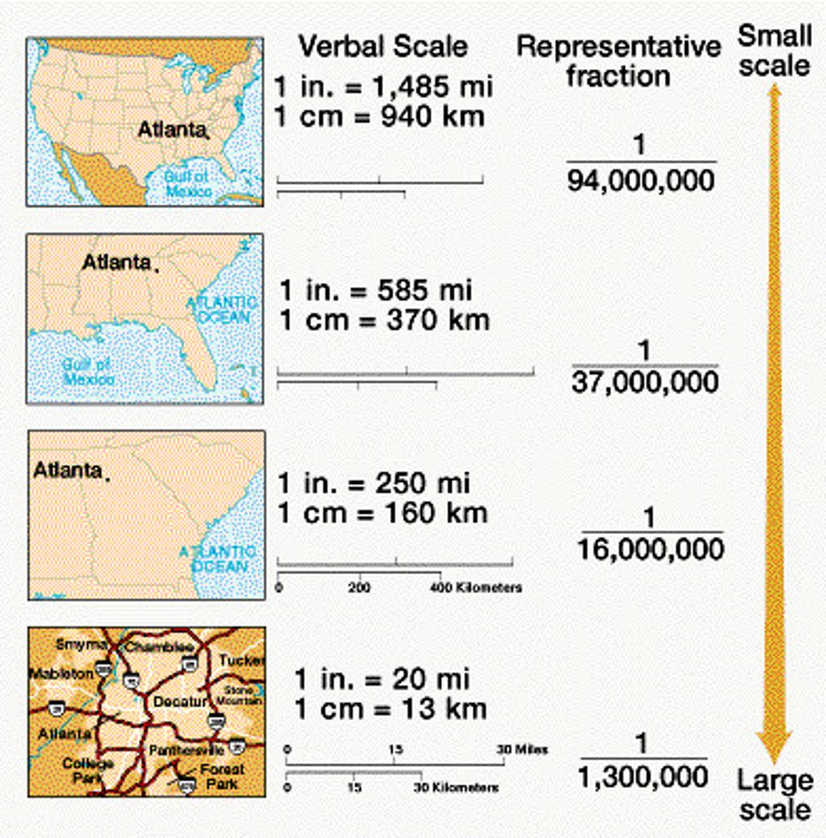
1:24,000
Which of the following map scales would be used for the topographic map shown?
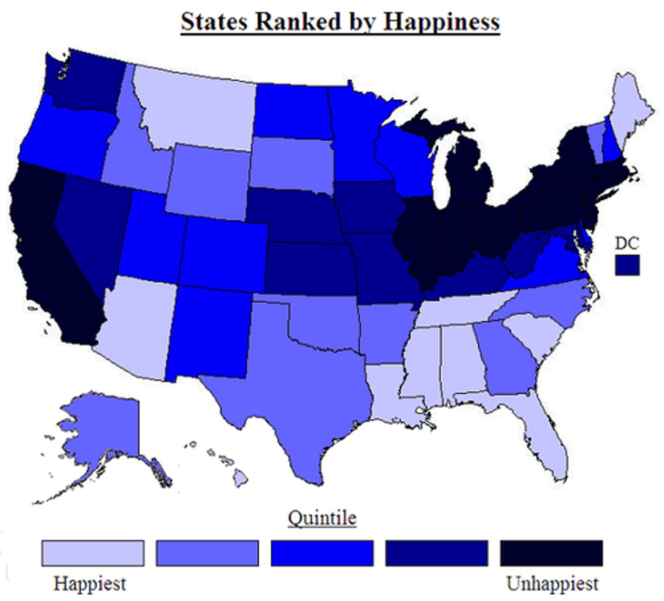
scale of analysis
Which of the following concepts best explains the differences among the values shown in the table?
The relative distance between Europe and North America decreased.
With the dawn of the Jet Age, international airline travel increased rapidly after 1950, and much of this early growth in jet travel was between Europe and North America. Which of the following best describes the spatial pattern suggested by the table?
Manhattan appears to have the highest population density at all three scales.
The darkest shading on the map indicates the areas with the highest population densities. Which of the following statements best describes the pattern of population density shown?
The map of the Borough of Manhattan, because it shows both population density and the pattern of streets.
Which spatial patterns on the maps shown would be most helpful to someone selecting the location for a new coffee shop?
Geographic information systems and global positioning satellites
Based on the geospatial data in the example shown, which combination of technologies provides real-time data to emergency call centers to route police, fire, and ambulance vehicles directly to incidents in the shortest possible travel time?
Functional region
Which of the following terms best describes the suburban area of Illinois where many residents commute to Chicago?
The Great Plains are less densely populated than the Midwest.
Which of the following patterns is evident on the map of population density?
Geographic information systems (GIS)
Which of the following geospatial technologies is typically used to analyze the data layers such as those shown in the maps?
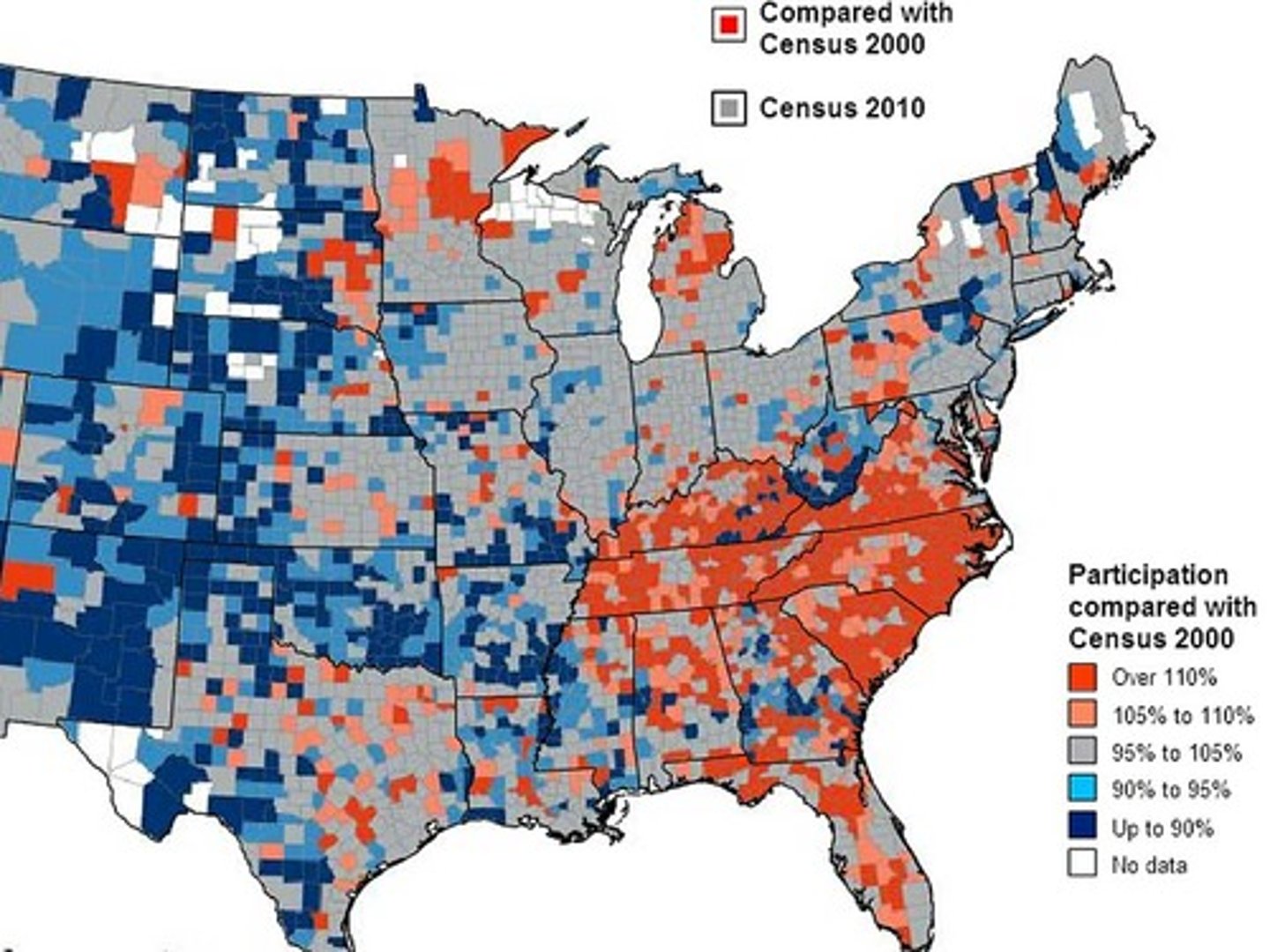
census surveys
The maps show data most likely collected through
The Mercator projection accurately shows direction but distorts the size of some areas compared to the Robinson projection.
Which of the following statements is an accurate comparison of the two map projections shown?
Choropleth
Which of the following map types is shown?
population in a cartogram
The data presented in the map shown depict
Vernacular
In his book My Tears Spoiled My Aim, John Shelton Reed explains the difficulty of defining the American South.
"Where is the South? . . . The South is, to begin with, a concept—and a shared one. It's an idea that people can talk about, think about, use to orient themselves and each other. People know whether they're in it or not."
Based on Reed's explanation, the South is best described as which kind of region?