Looks like no one added any tags here yet for you.
urbanization
refers to the movement of people to towns/cities and the resulting expansion of the rural countryside
influences on urbanization
changes in transportation and communication, population growth, migration, economic development, and government policies
site
the actual physical qualities of the place that a city occupies which can influence origin, function, and growth e.g. coastal plain, valley, mountains
situation
the relative location of a city (what is it near) which can influence origin, function, and growth e.g. located near shipping routes (Hong Kong, Singapore)
megacity
a large city with over 10 million people and found increasingly in the periphery and semi-periphery e.g. LDCs: Mumbai, São Paulo, Jakarta, Lima, Shenzhen, MDC: Paris
meta-city
a large city with over 20 million people and found increasingly in the periphery and semi-periphery e.g. LDCs: Delhi, Mexico City, Cairo, Beijing, Mumbai MDCs: Tokyo
suburbanization
the transformation of large areas of rural land to urban uses
suburb
a residential area located on the periphery of a city
suburban sprawl
unrestricted suburban growth and development over large areas spreading out from a city in which cars provide primary source of transportation
edge city
a concentration of residential and economic (business, shopping, entertainment) activity located in the suburbs
exurb
a residential area beyond the suburbs, often in more rural areas
boomburb
residential and economic urban area that is not the largest city in their metropolitan area, but has a large population (100,000+) and tends to be spread along highways (e.g. Irvine, CA)
world city
city that functions as a service center of the world economy driving globalization at the top of the urban hierarchy (hamlet, village, town, city, world city) e.g. New York City, London, Tokyo, Paris
network
a system of interconnected people, goods, information, transportation, communication, finance
globalization
the process of increased interconnectedness among countries most notably in the areas of economics, politics, and culture
urban hierarchy
settlements ranked by population, number of services and sphere of influence e.g. hamlet, village, town, city
rank-size rule
the idea that the population of a city or town will be inversely proportional to its rank in the urban hierarchy
primate city
a country's largest city, at least twice as large as the next largest city and more than twice as significant (usually the capital city) and represents national culture e.g. Paris, France and London, England
gravity model
a measure of the interaction of places used to predict the movement of people
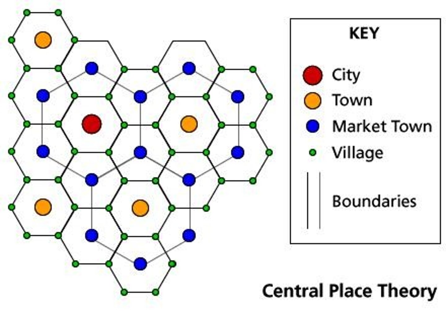
Christaller's Central Place Theory
explains the distribution, size, location, and interaction of settlements
Christaller's Central Place Theory
Explains the distribution, size, location, and interaction of settlements in an urban system.
Hinterland
The surrounding market area served by settlements.
Low-order goods
Products that are replenished frequently such as food and other routine household items.
High-order goods
Specialized items such as cars, furniture, fine jewelry, and household appliances that are bought less often.
Threshold
The minimum number of people needed for a business to prosper.
Range
The maximum distance people will travel to purchase goods and services.
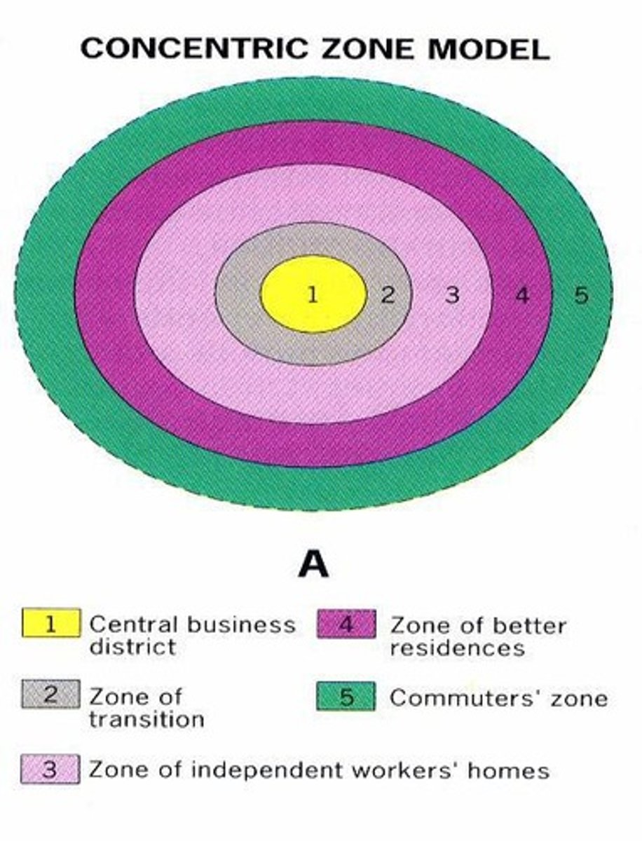
Burgess Concentric Zone Model
A spatial model of the American city suggesting the existence of five concentric rings around a CBD.
Zone in transition
The second ring in the Burgess model where industry and poorer-quality housing are located.
Zone of modest older homes
The third ring in the Burgess model typically for the working class.
Zone of better residences
The fourth ring in the Burgess model where more spacious houses for middle-class families are located.
Commuter zone
The fifth ring in the Burgess model made up of people who work in the center and choose to live in the suburbs.
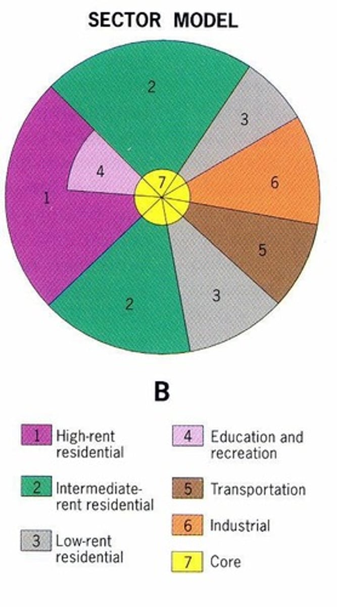
Hoyt Sector Model
A spatial model of the American city suggesting that land-use areas conform to a wedge-shaped pattern focused on the downtown core.
Central Business District (CBD)
The center of the city where business activities are concentrated.
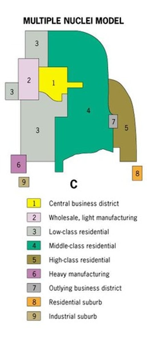
Harris and Ullman Multiple Nuclei Model
A spatial model showing the mid 20th century American city consisting of several land-use zones arranged around a CBD.
Nodes
Land-use zones arranged around a CBD, such as ports, neighborhood business centers, universities, airports, and parks.
Galactic City Model
An updated model by Chauncey Harris that describes the peripheral development of cities.
Incompatible land use activities
Activities that will not be clustered together, such as industries not placed near high-class housing.
Industrial and retailing activities
Develop outward from the CBD in the Hoyt Sector Model.
High-class housing
The most expensive houses built on the outer edge of established districts in the Hoyt Sector Model.
Middle class residential sectors
Develop in proximity to high rent residential areas in the Hoyt Sector Model.
Low-class residential
Located nearest to industrial and transportation zones in the Hoyt Sector Model.
Urban models
Models that are useful for explaining internal structures of cities.
Sectors
The city develops in a series of sectors as it grows in the Hoyt Sector Model.
E.W. Burgess
The creator of the Burgess Concentric Zone Model in 1923.
Homer Hoyt
The creator of the Hoyt Sector Model in 1939.
Chauncey Harris
Co-creator of the Harris and Ullman Multiple Nuclei Model in 1945.
E.L. Ullman
Co-creator of the Harris and Ullman Multiple Nuclei Model in 1945.
Galactic City Model
A spatial model in which American urban areas consist of a central city surrounded by a large suburban area, shopping malls, office parks, industrial areas, and service complexes tied together by a beltway, or ring road.
Bid-rent theory
An extension of the von Thünen model that implies that rent is equal to the value of the product minus production and transportation costs, showing what various land users are prepared and able to pay for access to the center market (CBD).
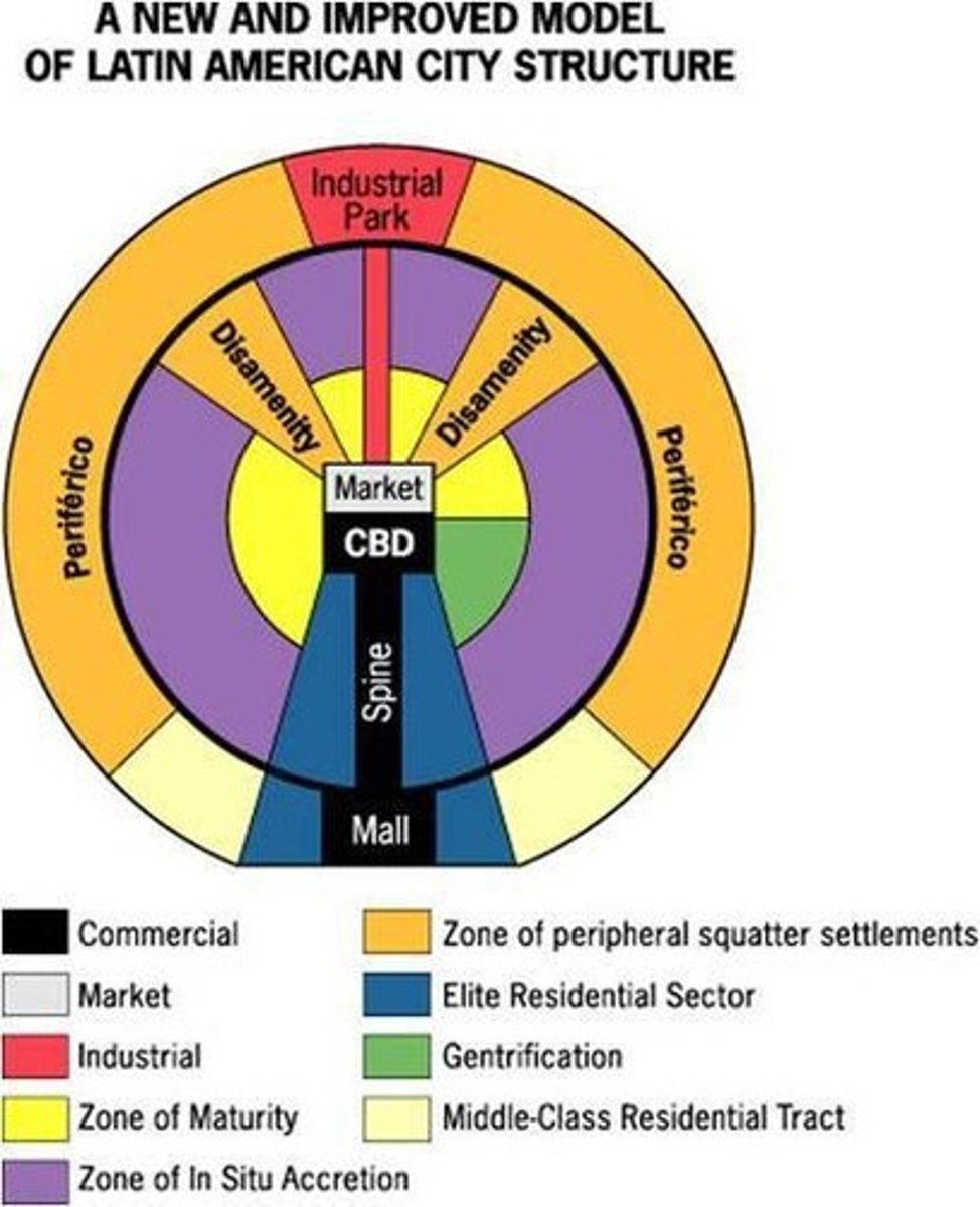
Latin American City Model
A spatial city model that includes a prestigious, commercial axis (spine) which emanates outward from the CBD and is surrounded by a peripheral area containing squatter settlements.
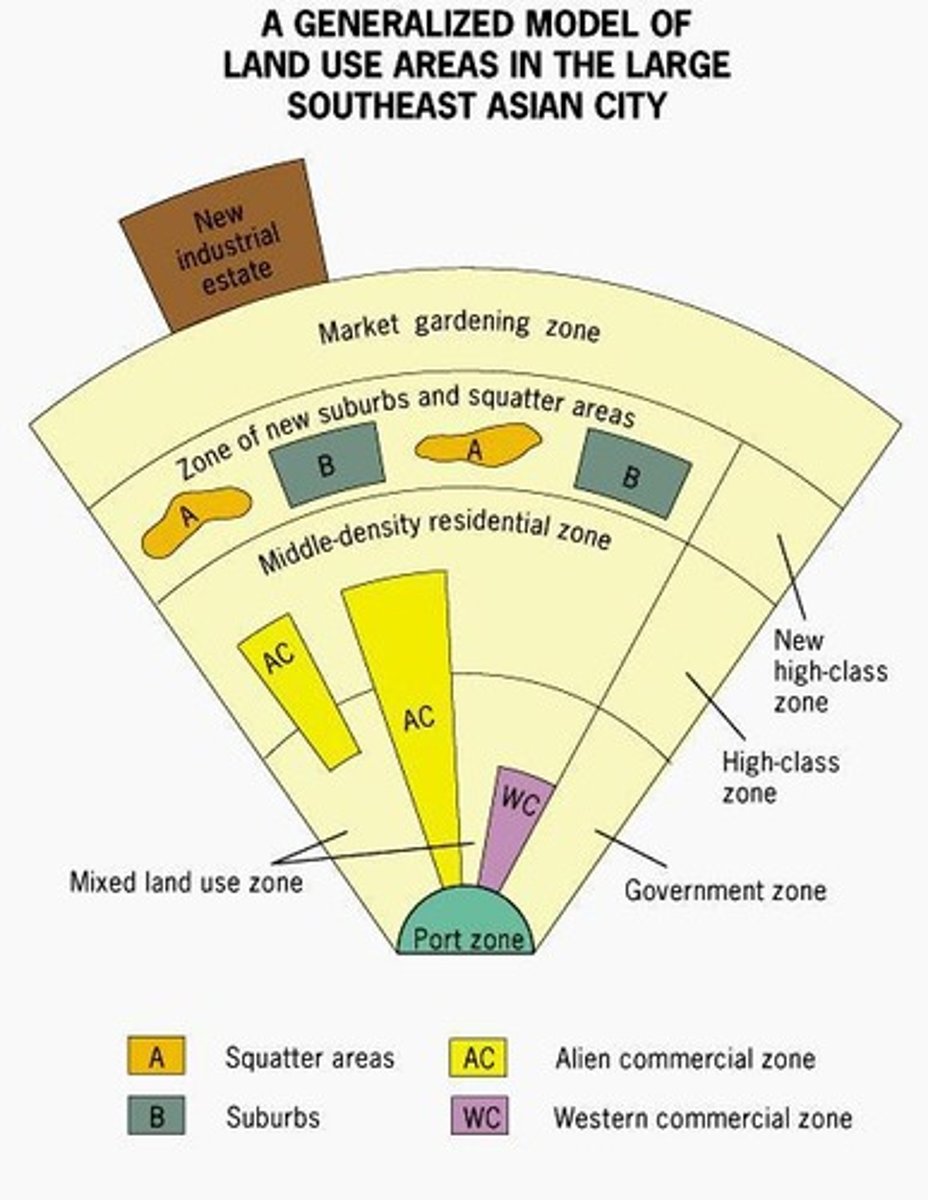
Southeast Asian City Model
A spatial city model that includes an old colonial port zone that is the focal point of the city reflecting a city oriented around exports, with the Western commercial zone and Alien commercial zone radiating outward from the port zone.
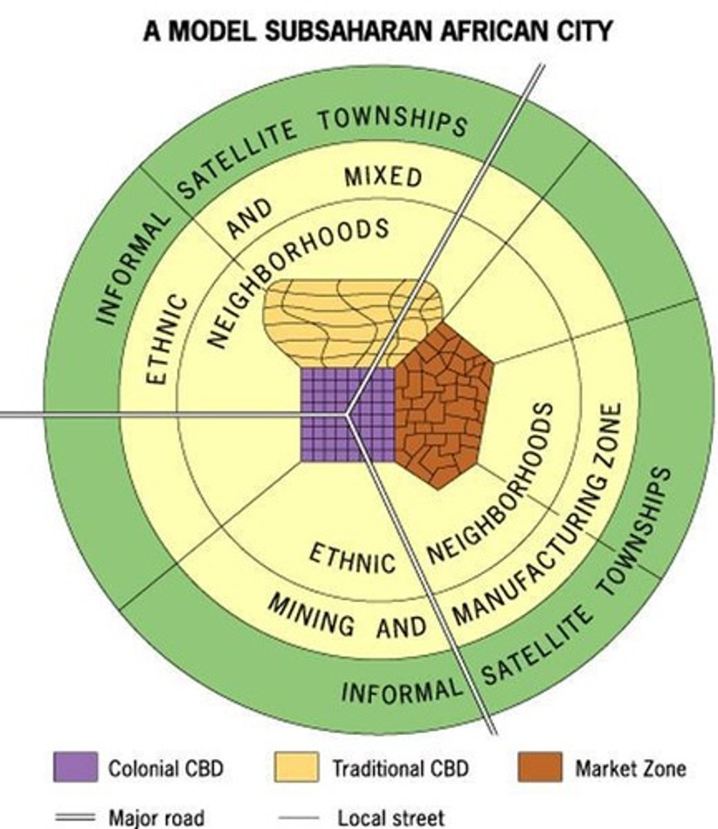
Sub-Saharan African City Model
A spatial city model that is difficult to formulate due to the imprint of European colonialism, often consisting of a colonial CBD as well as a traditional CBD, and a market zone surrounded by squatter settlements.
Housing discrimination
Discrimination in the purchase or rental of housing on the basis of race, gender, ethnicity, age, national origin, sexual orientation, gender identity, marital status, or veteran status.
Red-lining
A discriminatory real estate practice in North America in which members of minority groups are prevented from obtaining money to purchase homes or property in predominately white neighborhoods.
Blockbusting
A real estate technique used to encourage people to sell their property at a very low price by giving the impression that the neighborhood was changing for the worse, especially in reference to minorities moving in.
Affordable housing
Residential units that are economical for the section of society whose income is below the median household income.
Access to services
Measure of people's ability to pay for services without financial hardship (health services, infrastructure).
High crime rates
Contributing factors include lack of job availability, less access to quality schools, and real or perceived lack of opportunity.
Environmental injustice
Disproportionate exposure to communities of color and the poor to pollution and its effects on health and the environment.
Disamenity zone
Area located within the city characterized by slums and the homeless and in extreme cases are controlled by gangs or drug lords.
Zones of abandonment
Areas with lack of maintenance and investment, leading to deterioration and neglect.
zones of abandonment
areas with lack of jobs, declining land values and falling demand that cause people to leave and businesses to close
squatter settlements
residential areas characterized by extreme poverty with shelters constructed of found materials (scrap wood, etc.) that usually exist on land just outside of cities that is neither owned or rented by its occupants with little or no access to water, sewage, garbage removal, or education
land tenure
system regulating the rights to ownership and control and usage of land
inclusionary zoning
planning ordinances that provide affordable housing to people with low to moderate incomes
local food movements
food that is produced within a short distance of where it is consumed, often accompanied by a social structure and supply chain different from the large-scale supermarket system
urban renewal
the redevelopment of areas within an urban area, typically neighborhoods in economic decline
gentrification
the restoration of deteriorated urban areas by wealthier (mostly middle-income) people who move into, renovate, and restore housing and sometimes businesses
negative consequences of gentrification
displaces poorer residents, disregards the needs and interests of vulnerable groups, disregards lawful rights of vulnerable groups (e.g. coercion)
positive consequences of gentrification
added revenue from increased city productivity, new employment opportunities, improved housing, improved infrastructure, increase in visitors/tourism
functional fragmentation of government
refers to the way governmental institutions are dispersed between many local agencies including state, county, city and neighborhood levels
urban sustainability
the idea that a city can meet the needs of the present without compromising the ability of future generations to meet theirs in terms of economic, environmental and social impact
challenges to urban sustainability
managing suburban sprawl, sanitation needs, climate change, air and water quality standards, the ecological footprint of cities, and energy use
responses to urban sustainability challenges
regional planning efforts, remediation and redevelopment of brownfields, establishment of urban growth boundaries (e.g. greenbelts), and farmland protection policies
low density housing
land use pattern meant for a small number of residential homes that include a lot of open space and contain the fewest people per geographic unit
medium density housing
land use pattern in which residential units include multi-unit housing, such as townhomes as well as single-unit housing
high density housing
land use pattern in which land is occupied by residential units that include multi-unit housing such as high-rise buildings and contain the highest people per geographic unit
residential buildings and patterns of land use
reflect and shape the city's culture, technological capabilities, cycles of development, and infilling (development of vacant areas within existing urban areas)
location and quality of a city's infrastructure
affects economic development and social development
sustainable development
meeting human development goals while sustaining the natural systems that provide the natural resources upon which the economy and society depend
zoning
classifying land and identifying the types of activities that are permitted e.g. residential, industrial, commercial, agricultural
mixed land use
land development that blends a combination of residential, commercial, cultural, institutional and/or industrial uses
walkability
a measure of how friendly an urban area is to walking
transportation-oriented development
land use pattern that includes a mix of commercial, residential, office and entertainment space centered around or located near public transport; dense, walkable, mixed use development near transit that attracts people to connect communities
smart growth policies
urban planning that avoids urban sprawl and focuses on long term implications with sustainable design initiatives and guides development into more convenient patterns and into areas where infrastructure allows growth to be sustained over the long term
new urbanism
smart growth policy that creates walk-able, mixed land use neighborhoods with commercial and residential areas
green belt
an area of natural land on which building is restricted and whose main purpose is to curb the outward expansion of a large urban area e.g. London
slow growth cities
smart growth policies that concentrate growth in walkable urban centers to decrease sprawl
effects of urban design initiatives
CRITICISM: increased housing costs, de facto segregation, loss of historical character/place character; PRAISE: reduction of urban sprawl, improved walkability, improved transportation, improved and diverse housing options, improved livability, promotion of sustainable options
quantitative data
census and survey data provide information about changes in population composition and size
qualitative data
field studies and narratives provide information about individual attitudes toward urban change