Studio 1 salstentamen
1/65
Earn XP
Description and Tags
FM2611 svaren är baserade på kurslitteratur, hemsidor och annan information
Name | Mastery | Learn | Test | Matching | Spaced | Call with Kai |
|---|
No analytics yet
Send a link to your students to track their progress
66 Terms
Vad visar en isovistanalys som genomförs i ett stadsområde?
Isovist analysis offers a way of geometrically describing the spaces and forms of a building which can be seen from a particular position. As such, it combines a consideration of both fixed, building-related factors, such as space and form, and temporal, experiential ones, such as visibility and the impact of movement. Isovists are part of a larger field of study known as visibility analysis, which is concerned with quantifying the relationship between vision and behavior.
The more complex shape of the third figure defines all the points in space, and therefore the potential people, that can be seen by any of the people in the convex space who can also see each other. We call this type of irregular, but well defined, shape a 'convex isovist'. Such shapes vary as we move about in cities, and therefore define a key aspect of our spatial experience of them. (hiller pg 153)
2D

Förklara vad det innebär att gator/stadsrum har höga eller låga integrationsvärden? Vad kallas, enligt Bill Hillier, den analysmetod som används för att ta fram rumsliga integrationsvärden?
På vilka sätt påverkas förutsättningar för stadsliv generellt av den fysiska rumsliga strukturen, enligt Bill Hillier?
Vilken kombination av FSI och GSI beskriver generellt
a) villaområden
b) slutna kvarter i historiska stadskärnor
c) modernistiska bostadstorn
(Du behöver bara ange var FSI/GSI är låg/hög)
Ge exempel på vad som kan vara positiva och negativa effekter av hög densitet.
Vad är relationen mellan tomtindelning och urban mångfald?
Vilken typ av platser brukar normalt ha en kombination av hög lokal och hög global integration?
I Städernas stenar beskrivs begreppet urbanitetstal (u-tal), ett mått som introducerats av arkitekt Mikael Askergren. Vad mäter man med urbanitetstal?
Vad är skillnaden mellan geometri och topologi, och vilken av de tre figurerna nedan från Lars Marcus bok visar tydligast ett topologiskt samband?
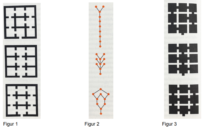
Lars Marcus skriver om det han kallar för den byggda staden som är något annat än det han kallar för den levda staden. Han skriver också om den första formen och om den andra formen.
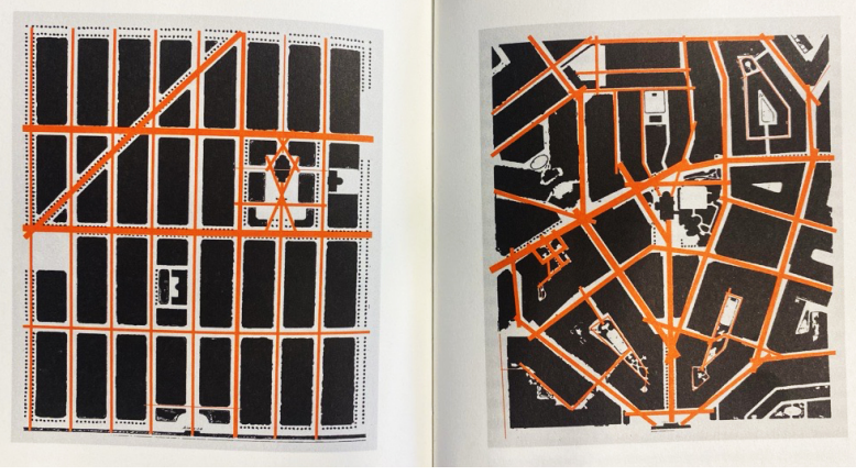
I de två stadsplanerna nedan syns dels svartfärgade kvarter och byggnader med vita mellanrum emellan, dels röd-oranga linjer med olika tjocklek i mellanrummen mellan kvarter och byggnader.
1A: Är stadens första form de svartfärgade kvarteren/byggnaderna med vita mellanrum eller är den de röd-oranga linjerna mellan kvarteren/byggnaderna?
1B: Representeras den levda staden av de svartfärgade kvarteren/byggnaderna med vita mellanrum eller av de röd-oranga linjerna mellan kvarteren/byggnaderna?
2: Som kontrast till rätlinjigt präglade stadsplaner förespråkade arkitekten Per Olof Hallman kring förra sekelskiftet mer ”konstnärligt” inspirerade stadsplaner, med vindlande gator och oregelbundet formade kvarter (se den högra stadsplanen nedan). Detta för att skapa mer livfulla städer. Varför är han enligt Lars Marcus fel ute?
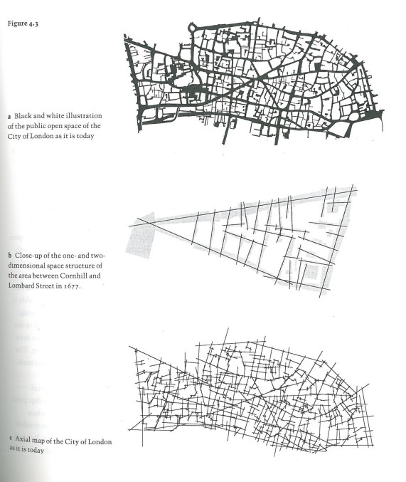
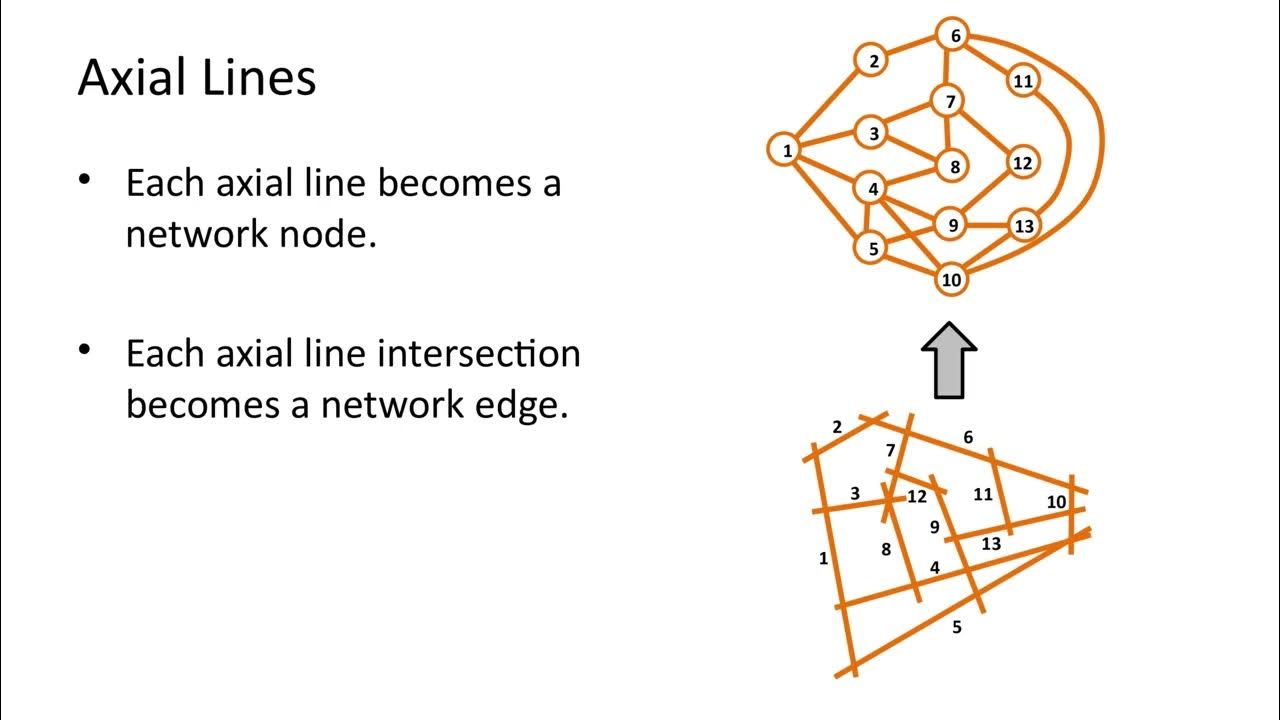
Vad visar en axialanalys som genomförs i ett stadsområde?
Again, we find a simple two-line logic underlying apparent complexity, and again we need have no doubt about its functional implication. It accesses the stranger to the heart of the city. An automaton could find the centre - so a stranger could. However, when we compare the two levels at which we find this two-line logic, there is a geometric difference which we can summarise in a simple principle: the longer the line the more likely it is to strike a building facade at an open angle, the shorter the line, the more likely it is to strike a building at a right angle.
Each line thus has a certain minimum line 'depth' from another, which is not necessarily a function of distance. It follows that each line has a minimum average line 'depth' from all other lines in the system. Because lines will always be shallow from some lines and deep from others, one might expect that this would average itself out.
We should then expect that the distribution of colours in axial maps will foreshadow densities of moving people. Because the colours are really rough indexes of precise numerical values, this proposition can of course be tested by selecting areas and correlating movement rates against integration values. However, because movement along a particular line is influenced in the main by its position in the larger-scale urban grid, we must take care to include enough of the whole urban grid in our analysis to ensure that each line in the area we are studying is embedded in all the urban structure that may influence its movement
Hillier s.159-161
”We should then expect that the distribution of colours in axial maps will foreshadow densities of moving people”, skriver Hillier. Varför ska vi förvänta oss det?
Because the colours are really rough indexes of precise numerical values, this proposition can of course be tested by selecting areas and correlating movement rates against integration values. However, because movement along a particular line is influenced in the main by its position in the larger-scale urban grid, we must take care to include enough of the whole urban grid in our analysis to ensure that each line in the area we are studying is embedded in all the urban structure that may influence its movement. s.161
Vilka är de fyra indikatorerna som visas i Spacematrix? Ange förkortningar med förtydligande.
(De engelska begreppen är tillåtna.)
Vilken indikator är viktig att ta hänsyn till om man siktar på en byggnadstypologi som ger en sammanhängande gatufront och en tydligare uppdelning mellan privat och offentlig platsmark? Ska den indikatorn vara högre eller lägre?
Både Baronbackarna och Skarpnäck ligger perifert, vilket begränsar deras möjligheter att kopplas samman med övriga staden, oavsett hur väl utformade de är i sig själva.
A) Förutom att Baronbackarna ligger perifert, vad är orsaken, enligt Lars Marcus, till att Baronbackarna inte åstadkommer den gemenskap som området är planerat för att skapa, och varför ger området enligt honom en falsk bild av gemenskap?
B) Förutom att Skarpnäck ligger perifert, vad är orsak, enligt Lars Marcus, till att Skarpnäck inte åstadkommer den stadsmässighet som området är planerat för att skapa.
FSI
Building intensity,
Floor space index
FSIx = (Fx/Ax)
Gross floor area (m2) - Fx
Area of aggregation x (m2)
Aggregation (lot (i), island (i), fabric (f), or district (d)
(Spacecalculator)
GSI
Coverage
Ground space index
demonstrates the relationship between built and non-built space
GSIx= (Bx/Ax)
Footprint (m2) - Bx
Area of aggregation x (m2) - Ax
Aggregation (lot), island (i), fabric (f), or district (d)
(Spacecalculator)
Geometry
Typology
Integration
Integration values in line maps are of great importance in understanding how urban systems function because it turns out that how much movement passes down each line is very strongly influenced by its 'integration value' calculated in this way, that is by how the line is positioned with respect to the system as a whole.
Pedestrian densities on lines in local areas can usually be best predicted by calculating integration forthe system of lines up to three lines away from each line, while cars on larger-scale routes (though not in local areas, where radius- 3 is the best predictor) depend on higher radius integration because car journeys are on the whole longer and motorists therefore read the matrix of possible routes according to a larger-scale logic than pedestrians.
By assigning each dwelling the integration value of the line on which it opens we can ask if burgled dwellings are significantly more segregated or integrated than unburgled dwellings. It turns out that burgled dwellings are significantly more segregated on average than unburgled dwellings.
Hillier 160-161
Natural movement
Proportion of movement on each line that is determined by the structure of the urban grid itself rather than by the presence of specific attractors or magnets.
Example the streets we feel like walking on without the presence of a resturant or other form of attractive spots.
Hillier s.161
Urban systems
An urban system, by definition, is one which has at least some origins and destinations more or less everywhere. Every trip in an urban system has three elements: an origin, a destination, and the series of spaces that are passed through on the way from one to the other.
If these arguments are right, it means that all the primary elements of urban form, that is the structure ofthe urban grid, the distribution of land uses and the assignment of development densities are bound together in the historical city by the principle that relates the structure of the urban grid to the by-product of movement. It means that under certain conditions of density and integration of the grid structure things can happen that will not happen elsewhere.
Urban morphology
they analyse a city’s evolution from its formative years to its subsequent transformations, identifying and dissecting its various components.
Borgargårdscykeln
procedural typology
focus on building types as the elemental root of urban form
Caniggia
Morphological analysis
1. Urban form is defined by three fundamental physical elements: buildings and their related open spaces, plots or lots, and streets.
2. Urban form can be understood at different levels of resolution. Commonly, four are recognized, corresponding to the building/lot, the street/block, the city, and the region.
3. Urban form can only be understood historically since the elements of which it is comprised undergo continuous transformation and replacement.
Thus form, resolution, and time constitute the three fundamental components of urban morphological research
Plan unit
Groups of buildings, open spaces, lots, and streets, which form a cohesive whole either because they were all built at the same time or within the same constraints, or because they underwent a common process of transformation.
Three schools of morphology
1. The study of urban form for descriptive and explanatory purposes, with the aim of developing a theory of city building (théorie de l’édification de la ville). Such studies are concerned with how cities are built and why. This is the primary purpose of geographers, and the Birmingham School in particular. Social scientists in the French School also have this purpose in mind when they carry out morphological studies.
2. The study of urban form for prescriptive purposes, with the aim of developing a theory of city design. Such studies concentrate on how cities should be built. This is the primary focus of the Italian School which has given this purpose a special direction, namely to develop a theory of building design resting on historical city-building traditions. A few French researchers have had the same intentions in their morphological analyses, seeing the purposes of their work as being to develop a théorie du projet basée sur les traditions d’édification de la ville.
3. The study of urban form to assess the impact of past design theories on city building. This is in the realm of design criticism, which makes the sophisticated distinction between the theory of design ‘as idea’, and the theory of design ‘as practised’. Such studies assess the differences or similarities between stated directives about what should be built (normative theories) and what has actually been built. The French School has championed this use of morphological analysis, tracing successfully the roots of modernism in urban design back to the eighteenth century. However, it remains a difficult mental exercise for many designers and planners, who tend not to spend time assessing the impact of their actions on the long-range life of cities.
Law of the indies
Dictated the layout of colonial towns all over the Spanish Empire.
Required that the church (temple), governor's palace (with prison), and merchant's palaces all stand around a central square containing market stalls, a fountain, public stocks, and a gallows for public executions.
New Urbanists
a single church dominated the main public space and a village green surrounded by big houses with small houses tucked away in the back replaced the colonial square. The neighborhood shopping mall was magically converted into a network of village-street-like armatures, while mundane offices, industrial production, and sewage treatment plants never appeared in the drawings, banished to heterotopic elsewhere-realms.
This created an orderly and disciplined hierarchy of elements within the enclave while simultaneously increasing the entropy of the world beyond their boundaries
The school of Birmingham
Planned Unit Development
1930s, breaking down urban growth into incremental additions of large enclave units developed by land subdivision around street armatures. From the 1930s onwards, Conzens provided insight into the settlement patterns of medieval Ludlow and other English cities, inspiring others to study colonial settlement patterns throughout the British Empire and America.
The School of Versailles
In the 1960s and 1970s, Jean Castex and the Versailles School combined the British preoccupation with typology and land subdivision with an Italian analysis of morphologies as networks of solid and void spaces in the urban fabric in their study of Versailles as a new-town development.
Typomorphological
First, type in typomorphology combines the volumetric characteristics of built structures with their related open spaces to define a built landscape type. This approach is in opposition to the monumental, tal, siteless typology of Durand, for instance. The element that links built spaces to open spaces is the lot or parcel, the basic cell of the urban fabric. Second, the inclusion of land and its subdivisions as a constituent element type makes land the link between the building scale and the city scale. Third, the built environment type is a morphogenetic, not morphological, unit because it is defined by time-the time of its conception, production, use or mutation.
The Venetian School
The concept of the room type, house type, block type, and street type were interrelated by a matrix, allowing the systematic study of medieval cities. In the 1960s, this methodology was applied to the systematic modernization and recombination of apartments within buildings and entire city blocks in Bologna without displacing the inhabitants.
typomorphological approach as describing a combinatory system of elements inside a three-dimensional matrix, including the voids that surround any building in a "built landscape." This landscape is a site-specific, time-specific system that takes into account local circumstances, especially the lot and property subdivisions of the city.
"reverse city" that expands the city out into the surrounding region, the "city territory
Rationalism, the "ensembles" of Collage City
Recomb urbanism
Enclave
"precincts" and of groups of buildings as "environmental areas," patches of order in the periphery worthy of consideration by designers.
an enclave is a self-organizing, self-centering, and selfregulating system created by urban actors, often governed by a rigid hierarchy with set boundaries. It serves to slow down and concentrate nomadic flows using a variety of techniques, from perimeter walls and gatekeepers to formal, geometric devices inin the plan of the settlement.
an outlying territory belonging to one country and lying wholly within the territory of another
"a distinct territorial, cultural, or social unit enclosed within, or as if within, foreign territory
derived from the same root as the verb "to cleave," to cut, break, or split off. Enclaves are bits of land metaphorically split off from their parent block and displaced to a "foreign" location; they have an internal coherence that refers to a distant place, one beyond their immediate surroundings
a closed perimeter (often walls, with a main gateway); guardians; a single, self-referential center; a system of codes and hierarchies built about a holy spot that defines the good (or at least a great good) in life
form around attractors or magnets, symbolic intermediaries that draw specific settlers to a certain spot. Among these are the typical urban sub-elements that we identified earlier: markets, cultural centers, specialty restaurants or food shops, places to meet friends, places of worship, immigration lawyers' offices, travel agents, cinemas. All these symbolic intermediaries act as attractors, giving E3 immigrant enclaves their peculiar characteristics.
Reverse City
open "space body" between buildings and perceptively analyzes the emerging suburban system in terms of the minimalist art and sculpture that formed the subject matter of Rosalind E. Krauss's 1983 "expanded field of sculpture"
linear patterns in this new field: "seriality, rhythms, [and] repetitions" space isolated villas and object-buildings along routes of transportation and communication.
Ribbon (finger city)
Space body
Voids between buildings as a built landscape in itself
three systems
comparable to dominoes, where elements only touch along their edges, as in Choay's "syntagmatic system" or the old Islamic city. Here, patterns emerge from the players' discrete actions over time
combination and movement governs the play of the pieces and relationships between actors, as in chess or checkers: pieces do not touch, but actors move pieces that are abstractly related to each other across a network or grid.
govern a system of pieces that not only touch but physically interlock with each other to form an overall pattern or grouping, as in a jigsaw puzzle. In this system, patterns of interlock remain syntagmatic because it is the character of local junctions that determine the viability of each move, yet these moves contribute to the coherence of a significant whole (literally, the big picture) that is bigger than any part.
Domino codes
Edge to edge touching with a system of local rules that govern the possibility of various arrangements or laminations
rec urb s.162
Theory of Good City Form
city as woven together from disparate, linear elements of ideal "fast" and "slow" growth strands, creating an ambiguous, hybrid tartan
Collage city
Rowe and Koetter provide a list of seven urban elements (though they give no real methodology for their combination):
(1) the armature-like "memorable street
(2) the enclave-like "stabilizer" square;
(3) another enclave-like element, the "potentially indeterminate set piece";
(4) an armature, "the splendid terrace";
(5) heterotopic "ambiguous or multivalent buildings";
(6) the heterotopic "nostalgia-producing" element; and
(7) a distinct type of heterotopia, the "garden.
the humanist urban-design tradition represented by Collage City
Good City Form
element (giving main headings only) is a territorial "framework" of armatures (star, grid, baroque networks, etc.); his second is the "central place" enclave settlement pattern (subdivided into single-, dual-, and multiple-center systems. including shopping malls); his third is a typological lexicon of "textures" (high slabs, towers in the green, dense walkups, ground-access walkups, courtyard houses, attached houses, freestanding houses, etc.); and his fourth is "open space" (enclave-like urban parks, squares and plazas, stretched-enclave-like regional parks and linear parks, playing fields, and wastelands).
CIAM's principle
segregation of the four functions (housing, work, leisure, and transport plus miscellaneous), as determined in the 1933 Athens Charter, in his Ville Radieuse project of the same year. He even conceived of new urban sub-elements to house the four functions.
Some of these sub-elements have indeed come into being, such as large slab blocks of housing, highways in the park, and skyscraper office towers clustered in the central business district.
Le Corbusier
Planned unit development?
Tecniques used by the Normans
A meeting hall faced the most sheltered anchorage and a market stood on the opposite side of the peninsula. Churches were only added later, off the main street. In Cork, the Norman expansion of the town repeated this same pattern first established by the Vikings across the river from the original fortress.
Plot interface
jane jacobs
plot frontage
low index -
high index
store fronts
Space syntax
Space matrix
Integration
how few turns do you have to take to get a certain destination?
prediction of how people will walk
Modifiable arial unit problem MAUP
danger of drawing random boxes on a map
Spanish law of the indies
mandatory norm across South America and throughout the Spanish empire
Urban sub-elements in this urban fragment included the governor's palace, church, merchants' houses, arcades and stores surrounding the central square, and the public symbols at its center: gallows, fountain, stocks.
generic urbanism
In the network city multiple centers of growth, at center and edge, provide actors with platforms for urban activities in enclaves that can vary enormously in morphology, with hybrid skyscrapers appearing on the periphery as well as at the center.
Archi Città
steady-state formation I noted three stages, the premodern, medieval, and Renaissance and baroque, all around a single center; in the Cine Città there was the binary dynamic of rich and poor, messy industrial city and reformist
Modern city
with multiple centers and hybrids. This progression from single centers to dual or split centers and thence to multiple centers is simple enough, a three-stage development from a "steady-state" pattern around one core to a binary system with growth alternating between separated cores to a multithreaded system with pulses of growth occurring at multiple, hybrid centers.
industrial city are polarized into monofunctional enclaves of production, consumption, and storage (E2) linked by "supplementary systems" of communication This specialization and segregation is in part due to actors who require specialized services, setting in motion the agglomeration of businesses in specialized enclaves, but is also the result of city regulations restricting uses
multiple, monofunctional enclaves (E2) connected by transport and communication channels
Territorial enclaves
cut off from a home territory, their inhabitants often long for links to that "home." The presence of enclaves in a city breeds a fragmentary quality
Examples
Forbidden City, Bejiing
Vatican, Rome
UN, New York
embassy compounds
(1) They have distinct interior spatial and social orders that help distinguish them from their surroundings. (2) Special attractors lying within them give them their peculiar characteristics; they relate to an ideal or distant community through a system of displacements. (3) They have perimeters or boundaries that define the limits of their interior spatial orders, which are organized around their special, central attractors. (4) Gates perforate these perimeters, connecting to transportation and communication channels that admit outsiders and allow insiders to access the larger urban complex and points beyond. (5) They are places of rest and stasis. (6) They may contain various urban typomorphologies within their perimeters but are often dominated by the repetition of one typological pattern. (7) They have gatekeepers and systematic, internal codes that serve to restrict the territory's social and functional order to specific people and uses. Designated actors enforce restrictions, which may take the form of functional codes and prohibitions or of restrictive building codes to exclude designated uses or people. Inhabitants, property owners, landlords, developers, street gangs, city regulations, or courts may enforce these codes and control access by various groups.
Self Organization and the city
self-organizing systems, which are based on landownership enclaves with specialized feedback loops that maintain and repeat a basic fractal pattern ina series of related assemblages
cellular structures form "fractal" (self-similar) systems within the city network
Heterotopic
When something occurs in a abnormal place
The Cellular Metropolis of Tomorrow
proposed a city based on 10 mall subcenters with high-density residential clusters around each and a hyperdense central commercial node serving all the subcenters, the whole to be set amidst parkland
Garden Cities of Tomorrow
based on the form of the mall as an E2 enclave "pavilion" floating in the void-space of the reverse city. This may be seen as a novel code inversion; its organizational and maintenance structures carry on the tradition of the Bedford Estate Office and garden city development offices
The Hearts of Our Cities
emergence of the E2 mall enclave as the subcenter of choice for suburban developers in communities based on the automobile. He recounts how there was, first, the small town center; then the strip development of pavilions; and finally, with the arrival of highways, the regional mall-form, creating a series of car-based subcenters around the original settlement.
The Galleria enclave
developed in stages, each increment representing a recombination of E2 mall elements and ultimately adding up to an E3 megamall. The first stage, designed by Guy Obata of Hellmuth, Obata, and Kassabaum (HOK), consisted of a 600-foot-long, barrel-vaulted armature that terminated in the atrium of the high-end Neiman-Marcus store at one end. Car parks, an office tower, and a hotel tower all plugged into this armature, which had a sports club (with running track) on its roof." The enclave was left open at the other end for Galleria II, a Portman-style, multistory, atrium-type enclave with attached hotel and office towers (1972). Galleria III followed in 1986 with an enormous, Pop, neoclassical facade and deliberately maze-like interior by Philip Johnson. Galleria IV filled out the original site with a compressed, L-shaped, Pop parody of the original Galleria I by the same architects.
bourgeois utopian edge-city
is mirrored by the dystopian American inner-city "hyper-ghetto" enclaves. The "classical ghetto" of Modernist segregation tio disintegrated as a self-organizing structure with the Civil Rights movement of the 1960s, allowing middle-class African Americans to move to the suburbs. Poorer members of traditional minority groups (and some newer immigrants) were left in inner-city areas in the 1970s and 1980s in a poverty trap that Loïc Waquant termed the "hyper-ghetto," an E3 enclave without good schools, police patrols, social support oport systems, or social organizations (other than churches)
classical ghetto enclave
assumed by early Chicago School sociologists like Park and Burgess needs to be redefined and extended to suburban E3 enclaves that share relatively uniform lifestyles and higher levels of wealth." Immigrant and minority enclaves, Abrahamson says, are longer confined to inner-city neighborhoods. Forms of segregation and stratification have changed, with class and income tending to replace ethnicity and race as criteria of exclusion.
The Structure of the Ordinary
shanty-towns run on basic rules about land subdivision that constitute an informal land control system. Typically, such rules begin with the claims of the first squatters and later allow the sale to later immigrants of plots that were first settled without legal title.
illustrates the enormous scale of these informal, bottom-up, stretched-enclave (-E3-) formations in his study of Mexico City. Here the displaced immigrants recreate the grids,row houses, or courtyard typologies of the villages from which they came, modified by their limited resources. The ubiquity of satellite dishes and antennas attests to the new immigrants' possibilities in houses that may have no running water, sewage disposal, or even even legal address (services much harder to construct or tap into than satellite radio or the electrical grid)
conceptual armatures
shared, communal, organizational, mental structures by which the city's inhabitants map it and its paths
Armature
A1
Roman towns were organized around a linear, elastic armature that tied all the disparate urban subelements (market, temple, theater, etc.) together into an identifiable image or urban signature
consist of main streets, squares, and essential public buildings linked together across cities and towns from gate to gate, with junctions and entranceways predominantly articulated
The armature acts as a linear sorting device, sequencing urban sub-elements along its length
elastic in Roman towns; urban sub-elements could be asymmetrically placed, irregular, and highly localized without destroying the overall pattern of the armature
s.201-203
A2
le corbusier
A3
Syntagmatic
how travelers would know which city they were approaching from the particular sequence of public buildings on the skyline, and how paintings would enshrine this sequence in a silhouette of the skyline
the linear sequential coding - syntagmatic
produced by rules working on a neighbor-to-neighbor basis along the spatial sequence
pertaining to a relationship among linguistic elements that occur sequentially in the chain of speech or writing