Geography GCSE AQA - Glacial Landscapes
1/50
There's no tags or description
Looks like no tags are added yet.
Name | Mastery | Learn | Test | Matching | Spaced |
|---|
No study sessions yet.
51 Terms
Why is it difficult to farm crops in glacial landscape?
- steep slopes, due to post ice erosion
- thin soil due to underlying rocks and steepness
- low temperature, high altitude- short growing season
- heavy relief rain, cause soil ersion
What is extensive agriculture?
animal grazing, suited to uplands
Describe forestry taking place in Scottish uplands.
Commercial farming is popular and covers 2 mil hectares of UK
How is forestry controlled in the UK?
Half is managed by the Forestry commission to ensure we don't run out of timbre. Forest cover has increased due to private investors.
How does tourism help the upland economy?
- most important source of income, employs more than any other industry
- attracts walkers and climbers
What is lake district slate?
distinctive blue- grey rock, used around the world as roofing and decorating.
How many quarries does the lake district have?
13
What is Pennies Limestone?
Widely used in building materials
What is Highland granite?
tough, resistant rock, range of uses from pavement ages to kitchen work surfaces.
Where is highland granite found?
Scottish island of Ailsa Craig
Why does quarrying take place in some glaciated areas?
-upland areas are composed of tough, resistant rocks
-lack of population means few dangers (and objections)
What are land use conflicts?
when the activities of two different groups of people are incompatible
What are conflicts due to reservoirs?
- glaciated troughs can be damaged to create deep and wide reservoirs
- local people might have to move
What are conflicts due to forestry?
- plantations block out the views and acidify the soil
- if planted to close together species on forest floor can suffer
- when cut down there is no vegetation to soak up rainfall
What are conflicts due to military training?
- is excellent for RAF
- during WW2 there were 6 crashes, killing 51 people on arran
- some don't like the noise
What are conflicts due to wind turbines?
- sutible sites for wind turbines
- no one to object, some say they spoil the view
What are objections due to hunting?
- private land allow hunting in some areas
-many nature lovers oppose it
How can developments and conservation be managed?
- maximum visitor numbers
-controlled areas out of bounds
- seasonal closure, to give areas time to recover
- restricted activities- land owner can restrict motor bikes e.c.t
What is a popular way to bring in money for upland areas?
films being made, e.g. harry potter
-brings money from actors staying there
-tourists
-landowners charge for land use
Why is the isle of Arran popular for day visitors?
easily accessable from scottish coast
What are tourist attractions on Arran?
- Goatfell, highest mountain
- Glaciated landscape, deep and wide u-shaped valleys and glaciated aretes
- sports, such as: climbing, running, paragliding, helicopter tours
What are positive impacts of tourism on Arran?
- relys on its income
- up to 200,000 annually
- creates 30 mil annually
- visitors often decide to move there counteracting the aging population
What are negative impacts of tourism?
- footpath erosion
-congestion at peak season
- many facilities are expensive to set up
Why is footpath erosion an issue?
because to replace it it will cost 140 per meter
Why do tourist centers encourage winter visitors?
To give perminent jobs to locals
How many people visit back to Arran?
4 in 5, many Canadians and Americans due to ancestory
What are Glaciers?
a mass of ice that moves very slowly downhill, found in cold (high latitudes) regions (high altitude)
When was the last ice age?
2 million to 10,000 years ago
Why are we in an ice age now?
because there is constant ice on the poles
When did the last ice age start/end?
started 1,000,000 years ago until 10,000 years ago
What happened during the last ice age?
during this time temperatures fluctuated and ice advanced and retreated four times. The northern and eastern parts of the British Isle were covered in it.
What erosion land forms do glacial create? (7)
- U-shaped valley (glacial trough)
- Flat bottom valley
- corries
- crete (two back to back glacial)
- glacial eroded the valleys to form u-shaped valleys
- glaciation leaves a sharper deeper valley
- boulders were left everywhere
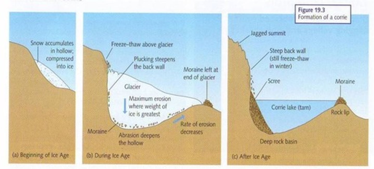
How is a corrie formed?
-Snow collects in a hollow
-Snow gets deeper, forming ice
-Ice accumulates forming glacier
-Hollow gets deeper due to intense abrasion
-Back wall is steeper by plucking
-Once ice is thicker it starts to slip due to rotational slip, this moves the glacier down the valley
-when the glacier has retreated there is often a tarm left in the deep hollow with a raised rock lip
How would the lake district have been during the last ice age?
covered in ice, only the highest caps visible (1km of snow)
What is easedale valley?
the glacier, probably originated in 3 east-facing corries the largest which is easedale tarn
- small glaciers merged to form the large glacier which formed the easedale glacier trough
What is easedale valley like now?
- two of the three corries are filled by tarns
-easedale valley is a broad u-shaped valley, with a misfit steam- easedale beck
Example of a ribbon lake?
grasmere valley has 2 ribbon lakes, grasmere and rydal water
What is morraine?
glacially formed accumulation of debris that occurs in formerly glaciated areas
What is medical morraine?
ridge of debris occurring on the surface of the glacier, when two glaciers meet medical moraine is formed
What is lateral moraine?
debris deposited along the side of a glacier
What is terminal moraine?
a ridge of debris formed when a glacier reaches its maximum limit during a sustained advance
What are eratics?
When a glacier melts it leaves eratics which is debris it carried
What are drimlins?
streamlined hillock, commonly elogated parallel to the former ice flow direction, composed to glacial debris and sometimes having a bedrock core.
What is the typical height of a drimlin? and where is it found
30-50m in height, 1000m length, commonly found in North England and Scotland.
How do drumlins form?
It is controversial, some scientists say that material i deposited under neither a glacier as grand moraine, this ground moraine is sculpted to form a drumlin by further ice movement.
What is an Aretes?
Sharp, steep-sided ridge. Formed when glaciers on the adjecent sides of a ridge grind away at it until it is sharpened.
Occurs when two corries become back to back
What is a peak mountain?
When two corries are formed on the same mountain giving a peak top (mount everest)
What is a hanging valley?
When a glacier cuts through a valley leaving behind a hanging valley
What is a truncated spurs?
rounded areas of land which have been cut off, rounded at the top but steep at the bottom, formed when glaciers move though the main valley and cut off spurs
What are glacial trough (U-shaped valley)
glaciers change a v shaped valley in to a u shaped valley
What is a ribbon lake?
large, narrow lake occupying a u-shaped valley, forms in a hollow when a glacier has more deeply eroded less resistant rock or it may fill up a valley behind a wall of morraine cross the valley.