EQ1- Why are coastal landscapes different and what processes cause these differences?
1/22
There's no tags or description
Looks like no tags are added yet.
Name | Mastery | Learn | Test | Matching | Spaced | Call with Kai |
|---|
No analytics yet
Send a link to your students to track their progress
23 Terms
What is a coast
Represents a boundary zone where land and sea meet and where both marine and terrestrial (land based) processes operate and interact.
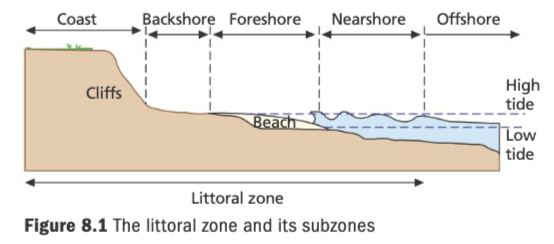
The littoral zone
The area of shoreline where land is subject to wave action.
Zones:
Offshore: The area of deeper water beyond the point at which waves begin to break. Friction between the waves and the sea bed may cause some distortion of the wave shape. coral reefs, barrier islands
Nearshore: The area of shallow water beyond the low tide mark, within which friction between the seabed and waves distorts the wave sufficiently to cause it to break. (breaker zone) There may be a breakpoint bar between the offshore and nearshore zones. wave cut platforms
Foreshore: The area between the high tide and the low tide mark. beach berm
Backshore: The area above the high tide mark, affected by wave action only during major storm events. sand dunes
Coastal accretion
deposition of sediment at coast usually from rivers carrying sediment + seaward growth of land
High energy environment + associated landforms
stretches of the Atlantic facing coasts, where waves are powerful(large fetch)
rate of erosion>rate of deposition
landforms include: headlands, cliffs, wave-cut platform
e.g. Cornwall
Low energy environment
stretches of the coast where the waves are less powerful/ where coast is sheltered from large waves
deposition of sediment brought to coast by rivers causes coastal accretion
e.g. Lincolnshire
Coastal landscape types
Rocky, cliff coastline: cliffs vary in height from few metres to hundreds of metres e.g. Jurassic coast
-areas of high relief + low relief
-result from resistant geology (withstands erosive forces of sea, rain and wind), high-energy environments
Coastal plains: have land which slopes towards the sea across an area of deposited sediment
Sandy e.g. Florida coast
-areas of low relief
-form in areas with less resistant geology, low energy environment, deposition>erosion, constructive waves
Estuarine e.g. Kent coast
-areas of low relief with salth marshes + mudflats
-form in river mouths, deposition>erosion, in a low energy environment, less resistant rock
Rapid change in littoral zones- inputs and outputs
constantly changing inputs + outputs
Inputs:
marine: waves, storm surges
atmospheric: wind, precipitation
human: coastal management
land: cliffs, geology
Outputs:
erosional landforms: cave, arch
depositional landforms: spit, beach
long term changes e.g. sea level variation due to climate change
short term changes e.g. tide variation, wave energy variation
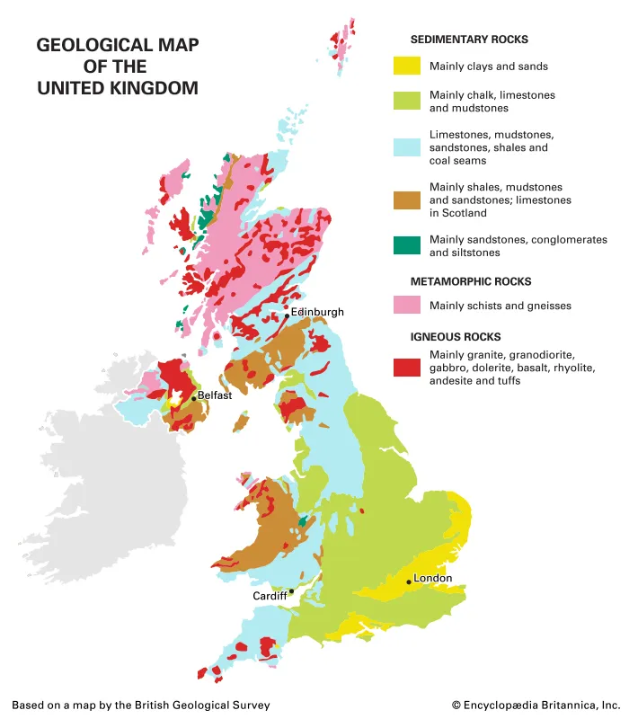
How can coasts be classified using long term criteria? (long term factors affecting coasts)
geology
Resistant rock coastline- W+N Britain
Igneous granite/basalt can withstand frequent storms with little erosion. Also has sandstone(sedimentary) + schists(metamporphic)
Less resistant rock coastine(coastal plain)- E+S Britain
Younger, weaker sedimentary rocks(chalk, clay, sandstone)
concordant/ discordant geology
sea level changes
tectonic processes can lift sections of land up(emergent coast), causing local sea fall, or lead sections of land to subside(submergent coast), causing local sea rise.
climate change causes sea levels to rise and fall in a 100,000 year cycle due to the change in the Earth's orbit shape (glacial +interglacial periods, ice ages cause water to freeze/ melt)
How can coasts be classified using short term criteria(short term factors affecting the coast)
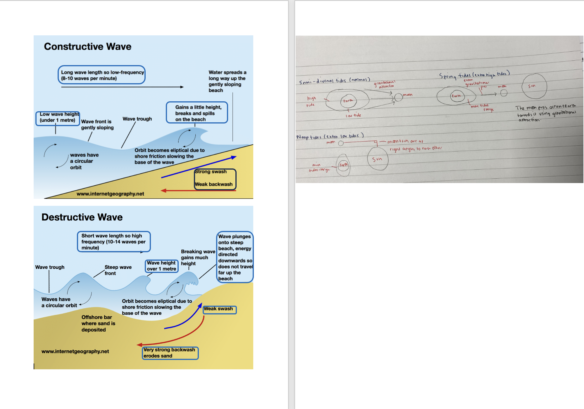
Waves
Destructive wave
-wavelength up to 20m(short)
Constructive waves
-wavelength up to 100m(long)
Tides
Tides: changes in water levels due to the gravitational attraction exerted on oceans by the moon(+sun)
Semi-diurnal tide: there are 2 low + 2 high tides each day
Spring tides: a greater difference between high + low tide-occur twice a month when sun+moon are in alignment
Neap tides: a smaller difference between high+low tide
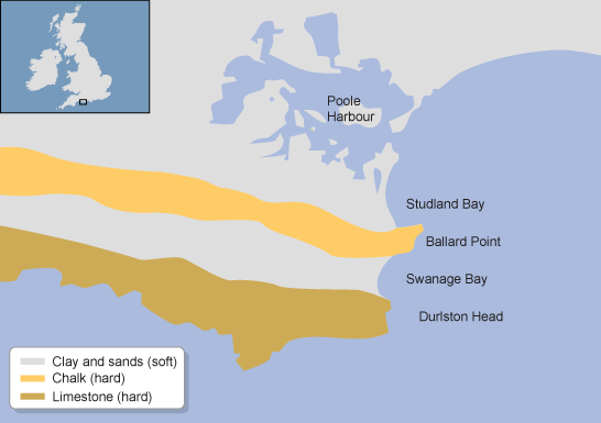
Concordant coastline
Alternating bands of hard + soft rock arranged parallel to the coastline.
Discordant coastline
Alternating bands of hard+soft rock arranged perpendicular to the coastline.
e.g. Dorset coastline consists of limestone (hard) and greensands (soft)
Haff coastline
Formed on concordant coastlines when sea level rise pushed bars of material towards the coast, trapping water in lagoons behind them.
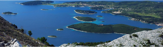
Dalmatian coastline
Formed on concordant coastlines.
Made up of offshore islands running parallel to coastline.
Tectonic activity folded the limestone into anticlines and synclines running parallel to the coast. As sea level rose, water flooded the valleys behind and overtopped the peaks of the mountains, leaving the islands (the peaks of the mountains)
e.g. The Dalmatian Coast, Croatia
Headlands + bays
Form of discordant coastlines
Headlands: made of more resistant rock, erodes slower so juts out into the sea
Bays: made of less resistant rock, erodes faster so caves inwards.
Strata
The different layers or rock within an area + how they relate to each other
Deformation
The degree to which rock units have been tilted by tectonic activity.
Faulting
Major fractures in rocks produced by tectonic forces + involving displacement of rocks on either side of the fault line.
e.g. Bantry bay, Ireland- limestone weakened by faulting, allowing more marine erosion + contributing to headland+bay.
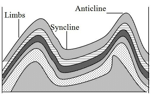
Jointing + folding
Jointing: fractures in rocks created without displacement (movement)- divide rock strata up into blocks with a regular shape.
Folding: bends in rocks produced by sedimentary rock layers being squeezed by tectonic forces, causing the rock to bend rather than break. The two main types are anticlines and synclines.
-Bends are more susceptible to fissures + faults, increasing rate of erosion.
Coastal morphology
More susceptible to erosion + weathering as pressure is exerted on weaknesses.
e.g. Lulworth cove- folding created heavy jointing of Purbeck limestone.
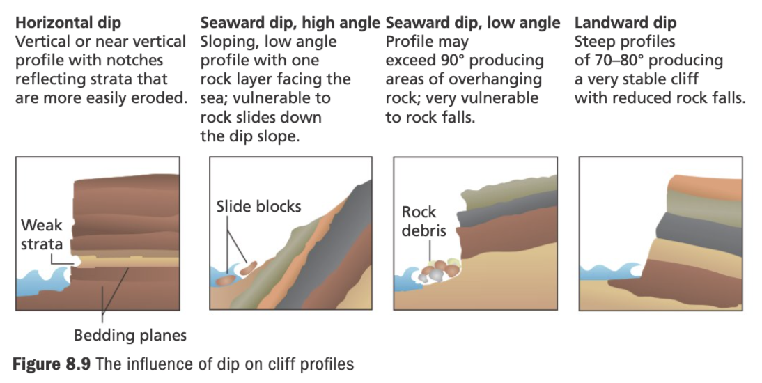
Dips + influence of cliff profiles
Dip: the angle the rock layer forms with the horizontal bedding plane. Bedding planes dip towards land or sea.
Seaward dips: Create gentler cliff profiles, vulnerable to mass movement like rockfall.
Landward dips: Create steeper profiles, vulnerable to erosion processes like hydraulic actions + abrasion.
What is geology?
structure: the way the rocks are disposed or geographically arranged(strata, deformation, faulting)
lithology: the makeup of each individual rock type(igenous, sedimentary, metamorphic)
Why do recession rates vary? Macro scale
Bedrock lithology
IGNEOUS
Form from the crystallisation of magma- more resistant to erosion and weathering. e.g. granite
igneous rocks contain crystals which increase strength of the rocks and reduce the weaknesses that could be exploited by physical processes- slower recession rate.
can either be intrusive (formed from magma inside the Earth) or extrusive (formed when magma escapes through vents on the Earth's surface).
SEDIMENTARY
Form from compacting and hardening of sediments into layers over time- rapid rate of recession via weathering + erosion. e.g. limestone, calcite is a reactive rock, as minerals are easily broken by chemical weathering which increases recession rate.
METAMORPHIC
Formed from change in structure of rock caused by variations in heat + pressure- resistant to erosion + slower recession rate. e.g. quartzite is an un-reactive rock due to interlocking crystal structure being more resistant.
Why do recession rates vary? Meso scale
Permeable/ impermeable rock
Rock permeability: the ability of rocks to absorb + transmit fluids through the pore spaces between grains in the rock being connected.
-They may also have numerous joints(regular cracks) causing it to be permeable e.g. carboniferous limestone
permeable rocks are less resistant to weathering bc water percolating comes into contact with a larger surface area that can be chemically weathered. e.g. Limestone weathered by carbonation
also, water can enter pores of permeable rock and freeze and expand, resulting in larger gaps(freeze-thaw weathering)
Jointing + folding
Jointing increases rate of recession by creating fissures which marine erosional processes can exploit e.g. hydraulic action
Folding increases recession rate as rock is stretched along anticlines and compressed in synclines, increasing angle of dip, causing joint formation, meaning they’re more easily eroded.
Why do recession rates vary? Micro scale
Sand dune succession
Bare sand colonised by plants (pioneer species) → modify environment by binding sand with their roots + adding nutrients when they die + decay.
Creeping plants help keep moisture in sand. These changes allow other species to colonise which modify environment by providing shade + improving soil.
As environment changes, new species colonise until it becomes stable. Finally, trees colonise.
Marram grass: an extremely tough pioneer species.
-horizontal roots grow up to 5m in sand to anchor themselves, preventing marine erosion.
-well established root network accumulates material making it less susceptible to erosion + wind moving sediment.
-add nutrients to soil when they die, improving quality of soil for new plants, increasing biomass of area.
Salt marsh succession
Mud + silt accumulate in a sheltered part of coastline, causing deposition. Mud begins to break surface (rise above sea level) + create mudflats.
Salt-tolerant plants start to colonise mudflats- pioneer plants. As level of mud rises, it is less frequently covered by water.
Conditions become less harsh + rainwater washes out some salt + decomposing plant matter improves fertility of new soil.
New plants colonise area over time.
Cordgrass: salt tolerant plant
-long blades trap sediment, building up muddy substrate that binds roots + facilitates more deposition, making it harder to erode- reduces rate of recession.
-binding of sediment stabilises mud, preventing it from being swept away by waves + tides.