Section K: Tectonic Processes and Landforms
1/92
There's no tags or description
Looks like no tags are added yet.
Name | Mastery | Learn | Test | Matching | Spaced |
|---|
No study sessions yet.
93 Terms
plate
large, rigid slab of solid rock
tectonics
greek origins: to build
what is the theory of tectonic plates
considers the earth’s crust and upper mantle to be composed of several large, thin, relatively rigid plates that move relative to one another as they ride atop hotter, more mobile material (asthenosphere)
what is wegener’s theory of continental drift
continents were originally connected as 1-2 large landmasses that have broken up and drifted apart over several million years
wegener’s theory was based on matching what
rocks and fossils
mountain belts
glacial evidence
coastlines of s. american and africa
what did wegener call his supercontinent
pangaea (275 million years ago)
why was wegener’s continental drift theory rejected
earth’s crust was believed to be too rigid to permit such large-scale motions
wegener did not offer a suitable mechanism that could displace such large masses for a long journey
What technological advancement after World War II helped develop the theory of plate tectonics?
Bathymetric mapping using sonar.
What three major ocean floor features were revealed by sonar mapping?
mid ocean ridges
seamounts
deep sea trenches
what are mid ocean ridges
underwater mountain ranges formed by divergent plate boundaries where new oceanic crust is being formed
what are deep sea trenches
Long, narrow depressions in the ocean floor formed at subduction zones where one tectonic plate sinks beneath another
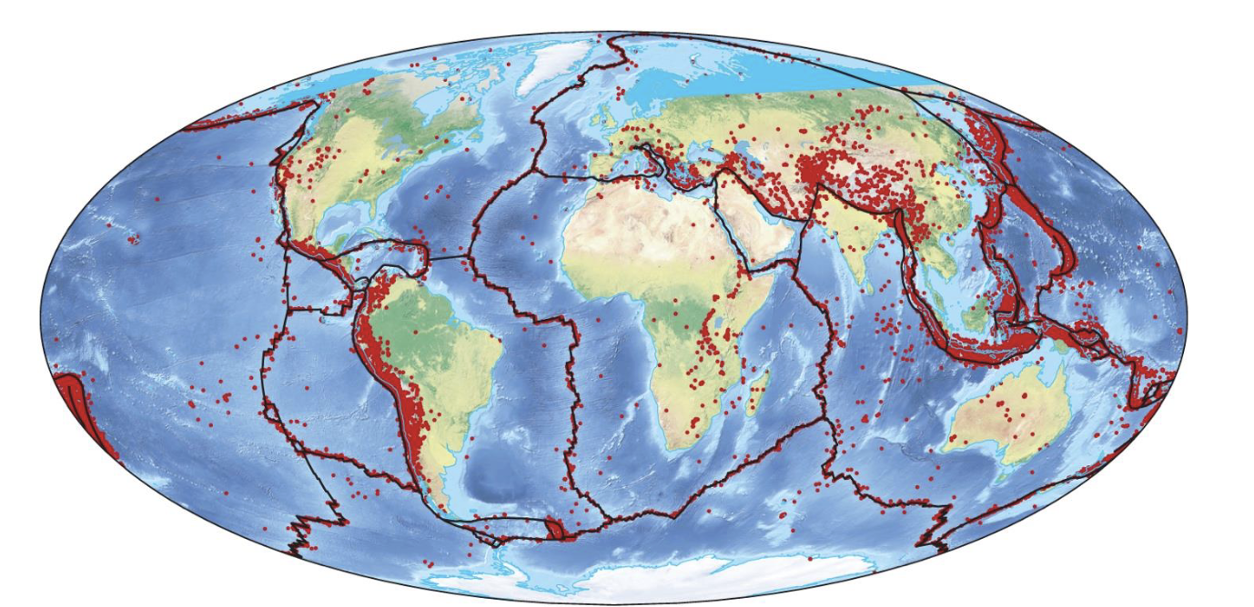
explain the figure
world wide seismographic network by 1960s.
lines = plate boundaries
red dots = earthquakes
all plate boundaries have earthquakes
what is seafloor spreading
The process where new oceanic crust forms at mid-ocean ridges and moves outward, pushing older crust away
What two types of evidence support the theory of seafloor spreading
paleomagnetism
ocean core sampling - age of ocean floors
what is paleomagetism
the study of Earth's past magnetic fields recorded in rocks
How does paleomagnetism provide evidence for plate tectonics
iron that has cooled in magma orients itself with the magnetic poles of earth which provides a record of past magnetic fields. the magnetic field has changed orientation at least 170 times
how does ocean core sampling provide evidence for plate tectonics
the youngest crust and thinnest accumulation of sediments is located at the mid ocean ridges
the oldest curst and thickest accumulation of sediments is located near continents
how do tectonic plates sit and how are they moved
they float on the asthenosphere and are moved by convection loops driven by earth’s internal heat
the mantle (magma) plumes from the mantle rise to the crust, spread horizontally and cool, moving segments of the crust
mantle plume
mostly stationary column of hot rock that extends from deep in mantle up to base of lithosphere
what are the two models for plate tectonic motion
seafloor spreading- oceanic ridges formed by currents of deep sea magma rising from mantle creating new crust on ridges
subduction - older, denser crust descends into earth (melted and recycled)
divergent plate boundary
seafloor spreading
rifting
moving away (extension)
what are the three types of convergent boundaries
continent to ocean (subduction)
ocean to ocean (subduction)
continent to continent (minor subduction)
convergence plate boundaries
plates coming together (compression)
transform plate boundaries
on sea floor: offsets in mid ocean ridges
on land: san andreas fault system
move laterally and horizontally (shearing)
how does seafloor spreading occur (plate divergence)
two plates move away from each other on the ocean floor due to magma upwelling (mantle plume) from asthenosphere
the extrusion of magma creates ridge like features
constructive boundary
rock is created
what is rifting
two continental plates move away from each other due to magma upwelling (magma plume) from asthenosphere
may cause a gradual split in the landmasses (east african rift valley)
produces distinct valley landscapes bordered by steep canyon walls
low land
area situated at a lower elevation than surrounding areas, with the potential for flooding
what does rifting cause
earthquakes, volcanic eruptions
what does rifting form
long mountain ranges separated by broad valleys
how do transform plate margins move
slide horizontally past each other
plane of motion is along a nearly vertical break (or fault) that extends through much of the lithosphere
san andreas fault system
transform plate boundary - n. american plate and pacific plate
what is a transform fault
mid atlantic ridge where the seafloor spreading creates transform faults
explain continent to ocean plate boundary
denser oceanic plate subducts beneath buoyant continental plate
destructive boundary because rock is destroyed
subduction trenches form next to continents
the subducting plate pulls the rest down, causing movement (slab pull)
what are composite volcanoes (continent to ocean)
magma rises, producing extrusive and intrusive igneous rocks
continental volcanic arc (a line of volcanoes on land)
andes mountains (s. america) or cascades (n. america)
both shallow and deep earthquakes (due to subduction)
explain ocean to ocean plate bondary
both plates have similar densities (eventually denser plate subducts)
features:
deep ocean trench
deep and shallow earthquakes
volcanic island arcs (aleutian island (alaska), japan, mariana islands (w. n. pacific)
destructive boundary
explain continent to continent plate boundary
2 converging continental plates of similar density
minimal subduction occurs between mountains (himalayas)
conservative boundary: rock is neither created nor destroyed
orogeny
a distinct period of mountain building
compression (plate convergence) can create mountains
terrane
a piece of lithosphere that is ‘added’ to a continental plate
what is an earthquake
a sudden release of accumulated tectonic stress results in an instantaneous movement of the earth’s crust
seismic waves radiate through the lithosphere
fault
crack in earth’s crust that results in the vertical and or horizontal displacement (movement) of one rock body relative to another
focus
the place in the lithosphere where the fault breaks
epicenter
point directly above the focus
worst damage, strongest shocks
what are the two types of earthquake waves
body waves and surface waves
what are body waves and explain the two types
they move through the interior of the earth
p waves (primary)
fastest moving waves (compress/relax)
s waves (secondary)
slower moving
side to side and up and down shearing motion
what are surface waves
only travel across the surface. slower than s waves and arrive after s waves
what is the richter scale
related to the amplitude of seismic waves on a seismograph (logarithmic scale)
when you jump from a magnitude 6 to 7 earthquake, how much more energy is released
32x increase
when you jump from a magnitude 6 to 7 earthquake, what is the increase in wave amplitude
10x increase
moment magnitude
an accurate measurement of the energy released as a rock moves at a fault
the moment magnitude is calculated using
area ruptured along fault plane
slip (amount of movement or slippage along the fault)
rigidity of rocks near the focus
when is the richter scale more accurate and when is the moment magnitude more accurate
richter for magnitude up to 7
moment magnitude for >7
what are the four fault types
normal fault
reverse fault
overthrust fault
strike slip fault
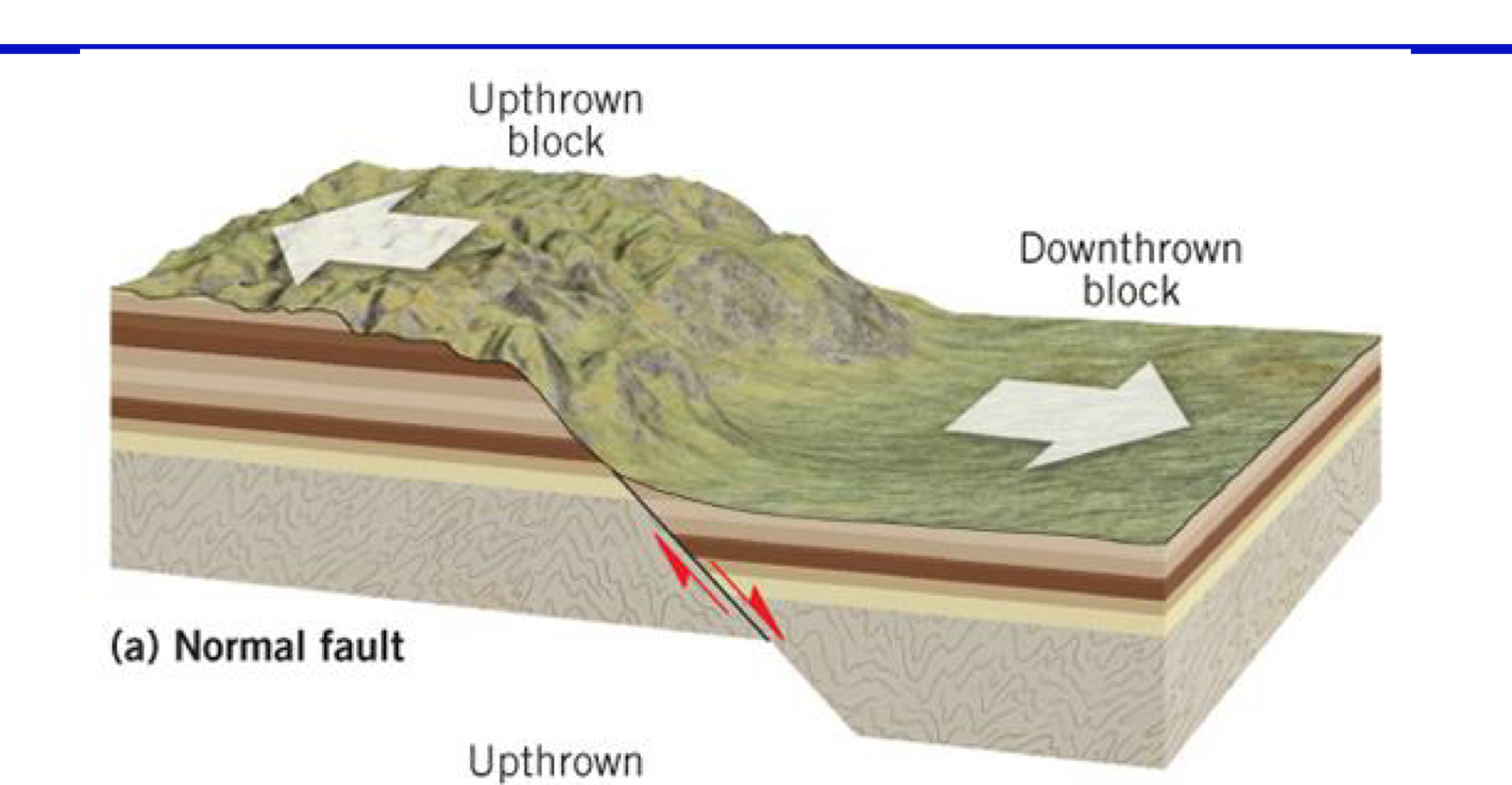
what is a normal fault
extension/tension
vertical displacement
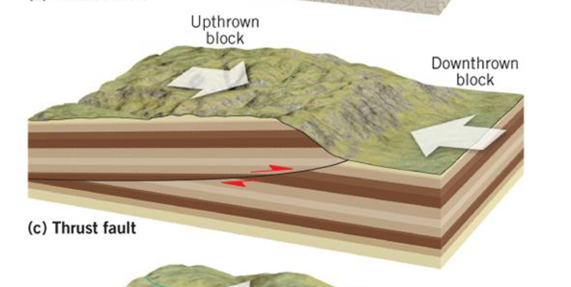
what is a overthrust fault
collision, compression
vertical and horizontal displacement
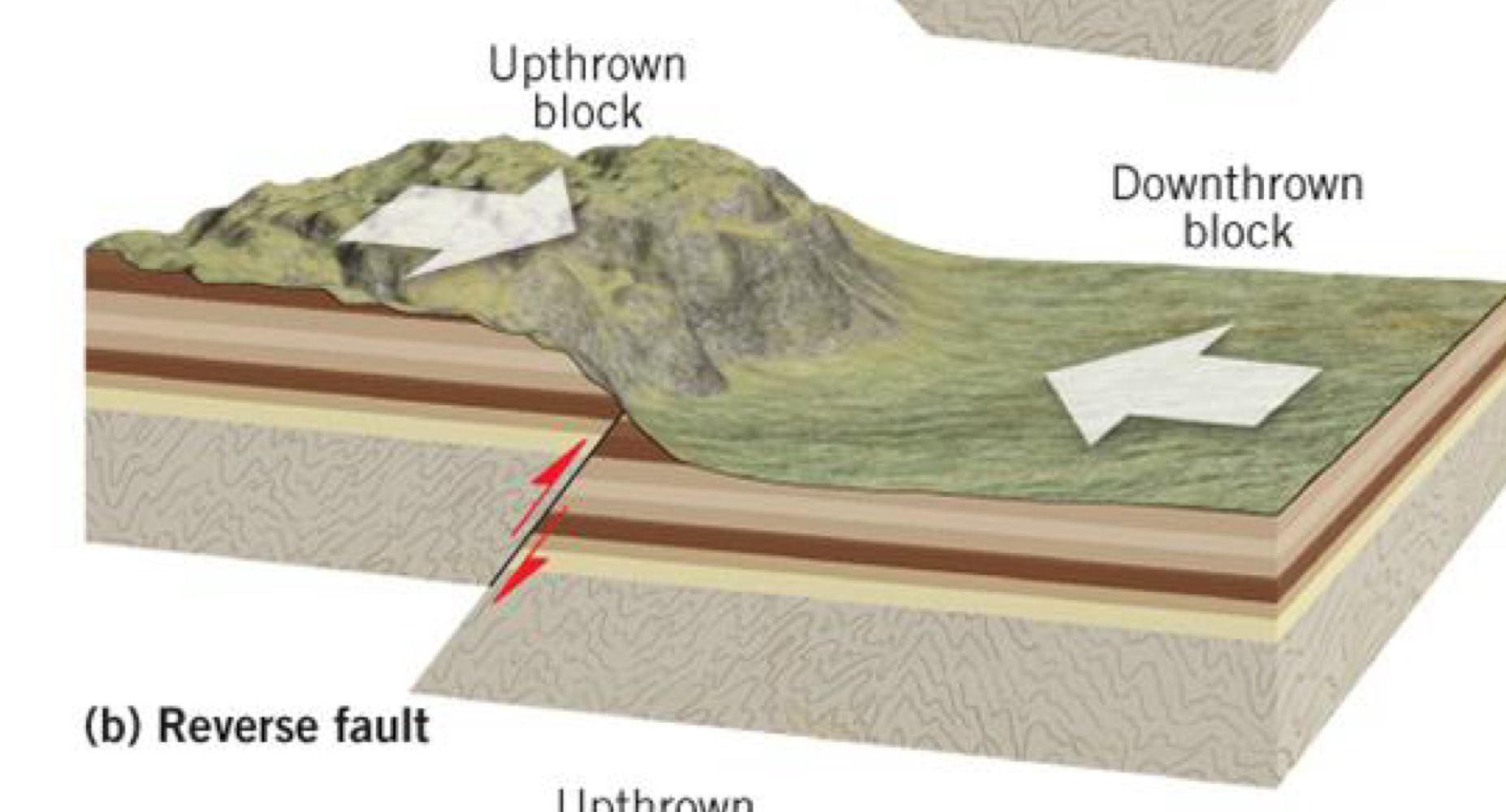
what is a reverse fault
vertical displacement
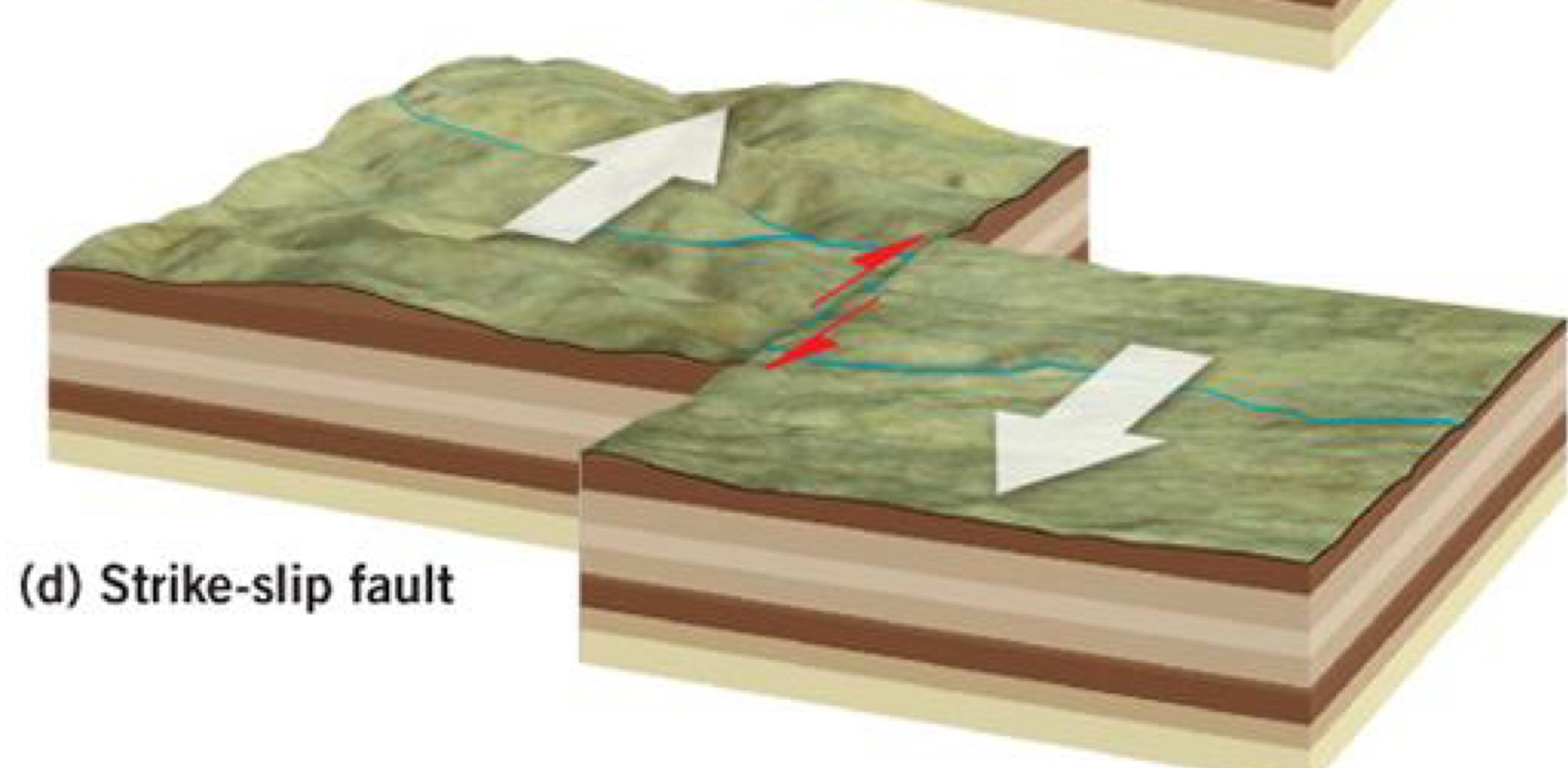
what is a strike slip fault
compression, shearing
horizontal displacement
what is a fault zone
weakness in crust, cracks and movement
what is a fault scarp
steep cliff formed by faulting
what is a horst
an upthrown block that lies between two steeply inclined fault blocks
what is a graben
a downthrown block that lies between two steeply inclined fault blocks
tell me about the magnitude and damage from the 2011 great east japan earthquake
9.0 magnitude earthquake
33 feet tall tsunami destroyed costal towns and villages, carried ships inland, flattened homes
damage to reactors at nuclear power plant, contaminating the area
ground shaking
shaking of ground decreases with increasing distance from epicenter. loose, unstable regolith, sediments and soil tend to amplify ground shaking
liquefaction
a phenomenon observed during an earthquake when water-saturated soil or sediments become soft or even fluid when ground shaking is strong
landslides
triggered by earthquakes
seiches
waves in lakes and reservoirs
tsunami
generated by underwater fault ruptures. barely perceptible in deep waters but build to heights up to 50 feet in shallow coastal waters
earthquake hazard warnings
ShakeAlert provides 10-60 second advance warning of the arrival of destructive seismic waves from a large earthquake on the u.s. west coast
precursors
warning signs of an impending earthquake such as foreshocks, water changes, radon gas, electrical conductivity changes, bulging ground surface, animal behaviour
what are volcanoes
a mountain or large hill containing a conduit that extends down into the upper mantle, through which magma, ash, and gases are periodically ejected
active volcanoes
have erupted in the last 10,000 years and could erupt again. (there’s hot, moving, mud pots, hydrothermal activity which means there’s magma heating stuff)
dormant volcanoes
not erupted for 10,000 years or more, but could awaken again
extinct volcanoes
have not erupted for tens of thousands of years and can never erupt again
extrusive volcanism
magma expelled while molten (lava)
intrusive volcanism
magma solidifies in shallow crust near surface
plutonic activity
magma solidifies far beneath surface
pyroclastic material
solid rock fragments, dust, ash, and lava bombs thrown in air by explosions
the ring of fire
plate boundaries exist all around the pacific rim
primarily subduction zones
around 75% of all volcanoes lie in the ring of fire
high silica (felsic) eruptions
thick, sticky magma (high viscosity) and violent eruptions
traps gasses, keeping it in the magma, building up pressure
associated with composite volcanoes and lava domes (rhyolite)
intermediate silica content eruptions
intermediate viscosity magma (explosive eruption)
composite volcanoes (andesite)
low silica (mafic) eruptions
thin, runny magma (low viscosity) and quiet, nonexplosive eruption
associated with shield volcanoes (basalt)
gasses escaping regularly so no pressure build up
what are cinder cone volcanoes
they are the smallest type of volcano, steep sided, consist of solidified magma fragments, rock debris, and ash (pyroclasts) that are ejected from a central vent, high erodible slopes
how are cinder cone volcanoes formed
they form very quickly following a single eruption, generally found near other volcanoes
what are composite/stratovolcanoes
they are intermediate-high silica level volcanoes with viscous lava that traps gases & builds up pressure, violent eruptions with alternating lava and pyroclastic layers, danger from pyroclastic flow
examples of composite/statovolcanoes
mt fuji, mt kilimanjaro, mt rainier, mt st helens
what is pyroclastic flow
they’re clouds (gas) of hot ash and dust that travel super fast (300km/h) down volcanoes, very low density so can travel across water
what are lava domes (plug domes)
small irregular shape, slow eruption of felsic lava (high silica) so magma is viscous and thick, viscosity leads to lava piling up around the vent - creating dome like shape
most explosive volcano
what are shield volcanoes
have very fluid eruptions
magma has low silica and low viscosity
lava flows as rivers of molten rock with little/no pyroclastics
very tall with shallow sloping sides
mauna loa hawaii
what is a hotspot and how is it formed
volcanoes found over a hot mantle plume in the asthenosphere
mantle plume is stationary, and plate moves over it
occurs under oceanic or continental crust
what is a seamount
extinct underwater volcano that does not reach the surface. high species diversity and biomass around sediments
what is a seamount chain
trail of islands and seamounts (submerged, eroded shield volcanoes) that developed over a stationary mantle plume (hotspot)
(hawaiian islands and emperor seamount chain)
what is a caldera
large bowl shaped depression formed by the collapse or explosion of a volcano
what are some volcanic hazards
volcanic gases - h2o, co, co2, so2, hcl, hf
lava flows - property damage
eruption column
pyroclastic density current
lahar
what is lahar
volcanic mudflow from heavy rain and or snow melt during an eruption
consistency of concrete when stationary