Instrument written
 Call Kai
 Learn
Learn Practice Test
 Spaced Repetition
 Match
Match Flashcards
 Knowt Play
1/109

There's no tags or description
Looks like no tags are added yet.
Name | Mastery | Learn | Test | Matching | Spaced | Call with Kai | Chat |
|---|
No analytics yet
Send a link to your students to track their progress
110 Terms
Compass deviation acronyms (2)
NOSE = North Opposite, South Exaggerate
ANDS = Accelerate North, Decelerate South
IAF
Initial Approach Fix
IAP
Instrument Approach procedure
MOCA
minimum obstacle clearance altitude
obstacle clearance, but navigation signal coverage is only guaranteed within 22 nautical miles of a VOR
preceded by *
MEA
Minimum En Route Altitude
both obstacle clearance and navigational signal coverage between radio fixes
unadorned number
MCA
Minimum Crossing Altitude
The specific altitude an aircraft must cross a fix when heading toward a higher MEA
Standard rate turns
360º = 2 mins
3º/second
Rt hand turns
VOR Receiver Checkpoint
go to specified checkpoint on ground
follow signs against designated radial (should be “from”)
max var = ±4º
VOT how to
tune to VOT
set course to 0º, should be centered and “from”
set course to 180º, should be centered and “to”
max var = ±4º
airborne VOR alignment
greater than 20 nm from vor
max var = ±6º
single microburst duration
seldom longer than 15 mins
H-VORTAC standard ranges
may change with obstacles
1000–14500 = 40 nm
14500–18000 = 100 nm
18000–45000 = 130 nm
45000–60000 = 100 nm
useful range = sum of two ranges
when is an alt airport necesary
projected weather is cig less than 2,000 cis less than 3 smal
minimums for an alt airport (@ETA)
precision approach = cig 600 vis 2 sm
non PA = cig 800 cis 2
no approach = can get to MEA and land VFR
If has an A in a triangle next to NA cannot be an alternate
fuel requirement
enough to airport, alternate + 45mins
approach speed categories
A < 91
91 ≤ B < 121
121 ≤ C < 141
141 ≤ D < 166
166 ≤ E
H = helicopter
basic med requirements
drivers license
48 mo physical
24 mo med ed course
malsr
med intensity rail to centerline
malsf
med intensity flashing to centerline
alsf
high intensity pattern to centerline
when might there be obstacles penetrating Obstacle Identification Surfaces
vis is no lower than 3/4
min IFR en route alt
2000ft above mountain obst
1000ft above other obst
pressure alt
indicated when alt @ 29.92
density alt
requires adjustment for temp
when to file IFR flight plan
controlled airspace with IMC exists
when to begin leveling off
at 10% of vertical speed
Day VFR requirements
A = airspeed
T = tachometer
O = oil pressure
M = Manifold pressure
A = altimeter
T = temp gauge for engine
O = oil temp
F = fuel gauge
L = landing gear indicator
A = anti coll lights
M = mag compass
E = ELT
S = seatbelts
Night VFR reqs
ATOMATOFLAMES
F = fuses
L = landing light
A = anti coll light
P = position lights
S = source of electricity
IFR reqs
ATOMATOFLAMES + FLAPS
G = generator or alternator
R = radios, both comm and nav
A = altimeter
B = ball (slip skid)
C = clock
A = attitude indicator
R = rate of turn
D = directional gyro (compass)
AIRMETS (2)
airmen’s meteorological, moderate intensity
Sierra = IFR conditions and mountain obscure
Tango = turbulence, surface winds greater than 30 kts, low level wind shear
WA abbreviation
Textual airmet
(weather, airmet)
WS abbreviation
sigmet
(weather, sigmet)
severe icing, turb, sand or dust storms, volcanic eruptions
WST abbreviation
sigment
(weather, sigmet thunder etc)
severe thunder, hail, tornado
WC abbreviation
cyclone sigmet
(weather, cyclone)
CIG abbreviation
ceiling
010 = 1000ft
TS abbreviation
thunderstorm
TURB/TB abbreviation
turbulence
ICE abbreviation
icing
LLWS abbreviation
low level wind shear
VA abbreviation
volcanic ash
MOV abbreviation
moving
STNR abbreviation
stationary
INTSF abbreviation
intensifying
WKN abbreviation
weakening
NC abbreviation
no intensity change
9900 meaning
light variable winds
IFR conditions
cig less than 010, vis less than 3 nm
MVFR condition
cig 1000-3000 vis 3-5 nm
where does ice occur first
tailplane, or small objects
void time
“clearance void if not off by” from ATC @ non towered
if no take off, must contact within 30 mins
total microburst shear
2x peak outflow wind
delta wind, head + tail wind
high level sig wx prog chart jet stream speed indicators
shaded triangle = 50 kts
slanted dash = 10 kts
sum
calculating CAS
add 2% to indicated for every 1000ft
MDA
min decision alt
non precision min alt (VOR, LOC)
DA
min decision alt for approach with glideslope (ILS) or glide path (LPV, LNAV/VNAV)
ISA
int standard atmosphere
29.92, 15ºC
temp lapse rate (standard)
2º for every 1000 ft
approach category speed
stall x 1.3V
VOR changeover point
stick “s”
in absence, divide length by 2
thunderstorm stages (3)
cumulus
mature
dissipating
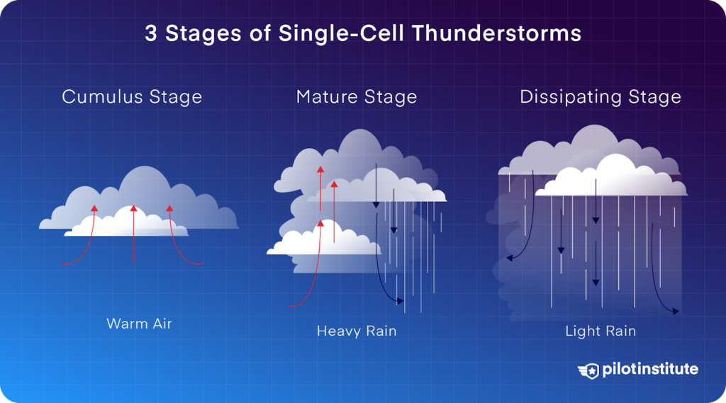
cumulus stage
strong continuous updrafts
light to moderate turbulence
mature stage
violent up and down drafts
peak vertical development
anvil pointing downwind
heavy rain
Severe-to-extreme turbulence, low-level wind shear, microbursts, frequent lightning, severe structural icing, and large hail
dissapating stage
downdrafts, light rain
lower cloud breaks apart
higher anvil remnants
downdrafts, high-altitude lightning, residual wind shear
class E VFR reqs above 10,000 MSL
vis 5 nm, vertical 1000ft, 1mi horizontal
when is stabilized approach required
1000ft above TDZE
wind code for greater than 200 kts
speed coded as 99, 500º added to wind direction
precision approaches
vertical and lateral guidance
ILS = Instrument Landing System
Ground Based Augmentation System (GBAS) Landing System (GLS)
Precision Approach Radar (PAR)
Non precision approaches
only lateral guidance from the localizer signal
RNAV = Area Navigation - must have Wide Area Augmentation System (WAAS) GPS receiver (VNAV is vertical guidance)
LP = Localizer Performance - Wide Area Augmentation System (WAAS) GPS receiver
VOR
LOC = Localizer - utilize only the localizer equipment of the instrument landing system (ILS), Aircraft must be equipped with a navigation receiver
LDA = Localizer Type Directional Approach - approach is offset from the runway 6-12 degrees
Approaches with Vertical Guidance (APV)
not precision approach standard, but does provide horizontal and vertical guidance
contact approach
only pilot requested
means can deviate from IAP by visual surface reference
VFR vs IFR cruising altitudes
Odd 0-179
Even 180-359
VFR = that +500
when to use true vs magnetic course/heading
true during planning
magnetic during operation
STAR
standard terminal arrival procedure
can be assigned unless put no STARs in IFR notes
PBN
performance based navigation
RNAV and RNP
satellite and airborne avionics capability
max holding pattern speeds (3 altitude ranges)
MHA-6000 = 200
6000-14000 = 230
14000 and above = 265n
Normal FSS frequency
122.2
Composite flight plan
both VFR and IFR segments
contact FSS for clearance to switch
YFR
composite with IFR first
ZFR
composite with VFR first
ARTCC
air route traffic control centers
controls traffic, some weather info
RCO
extends FSS range
FSS
preflight, inflight advisories, search and rescue
ft/min ranges for altitude changes
less than 1000 ft difference = 500-1500 f/m
greater than 1000 ft difference = as fast as practical, then above once less than 1000
EFC time
expected further clearance time
When are attitude indicator errors at the max
post a 180º turn
unusual attitude recovery order
power
level wings
level pitch
attitude indicator errors (3)
Nose-up display during rapid acceleration
Nose-down display during rapid deceleration
Small pitch or bank errors after a 180-degree turn
how does altitude change with a higher baro
higher baro = higher indicated alt
venturi system
produces vacuum for gyros
gyro instruments
heading
attitude (suction)
turn slip
pitot static instruments
airspeed
VSI
altimeter
IMC Illusions (8)
Inversion
Coriolis
Elevator
False horizon
Leans
Autokinesis
Graveyard spiral
Somatographic
Inversion
quick change from climb to level, feels like falling back
coriolis
moving head during constant turn feels like rotation around different axis
elevator illusion
sudden updraft feels like a pitch up
false horizon
seeing any pattern and thinking its a horizon
leans illusion
after correcting slow bank you still think youre banking (opposite dir)
autokinesis
thinking a stationary light is moving because of staring
graveyard spiral
leans, but doesnt acknowledge and goes back into a turn
loose altitude
pulls up tightening turn
somatographic illusion
power increase or decrease feels like pitch up or down