Oceanography
1/141
There's no tags or description
Looks like no tags are added yet.
Name | Mastery | Learn | Test | Matching | Spaced |
|---|
No study sessions yet.
142 Terms
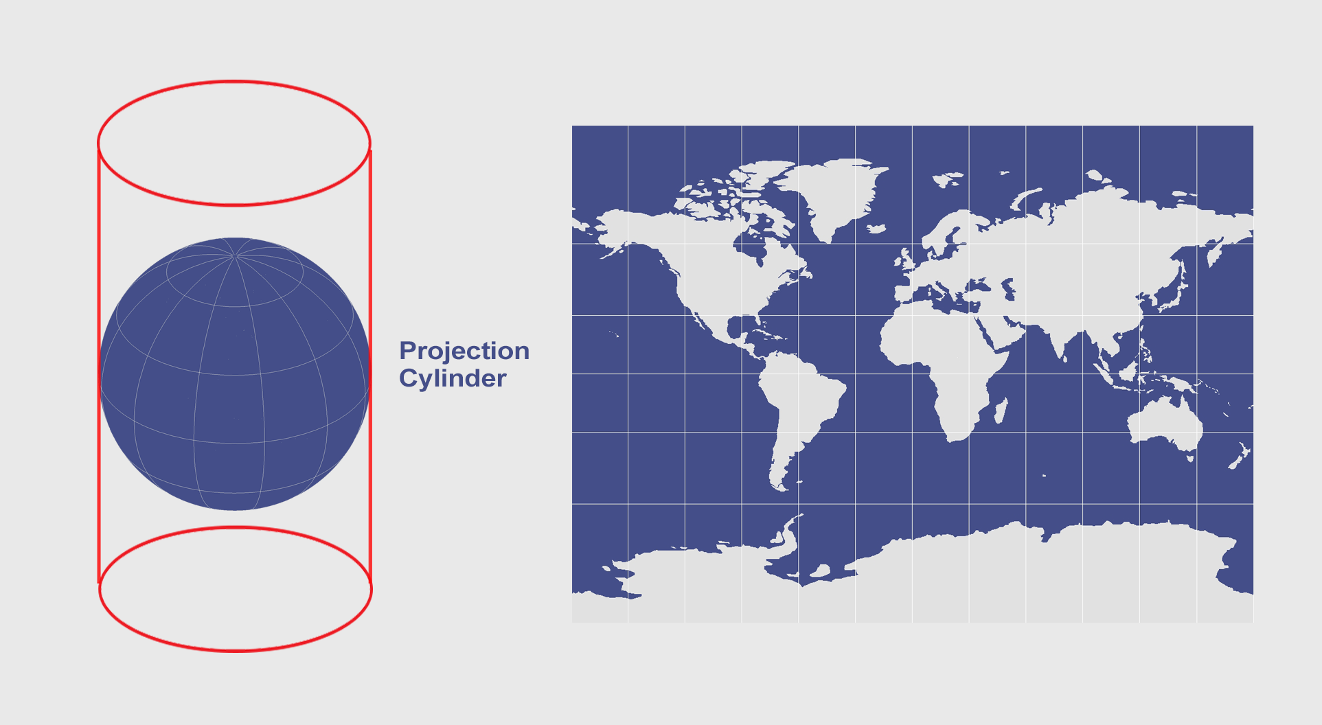
useful for navigation because it preserves angles (allowing for straight line courses to be easily plotted)
easy to use and familiar to many people
What are the advantages of the equatorial cylindrical (mercator projection)?
area distortion: distorts sizes (particularly near the poles) makes landmasses appear bigger than they are
limited use for a global perspective (does not help in understanding the true relative sizes of continents or countries)
latitude distortion (increases as one moves away from the equator and leads to inaccuracies in represntation of landmasses)
what are the cons of the equatorial cylindrical (mercator projection)?
equatorial cylindrical (mercator projection)
What is this?
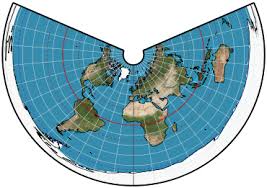
maps polar regions and is centered on one of the poles (North or South) with the earth’s surface projected onto a flat plane tangent to the pole
preserves direction from the pole which can be helpful for navigation and meteorological purposes in polar regions
relatively simple because it’s just a projection of earth’s surface onto a plane tangent to one of the poles
what are the advantages of polar tangent plane map projection?
distortion away from the pole: as you move further from the pole, distortion increases. especially areas near the equator. unsuitable for global use
limited coverage: only useful for one hemisphere (either North or South Pole) does not give an accurate view of the mid-latitude or equatorial regions
scale variations: distances and areas away from the pole are distorted
what are the disadvantages of polar tangent plane map projection?
polar tangent map projection
what is this?
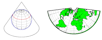
projects earth surface onto a cone that touches or interescts the globe along one or two standard parallels (usually at latitudes within polar regions) when cone is unwrapped it gives a flat map where meridians appear as straight converging lines, and parallels form arcs or curves
accuracy near poles: minimal distortion near poles. ideal for studying high latitude areas
preserves shape over small areas: can be useful in oceanographic navigation or detailed local analysis
what are the advantages of the polar conic map projection?
distortion away from poles
limited coverage: not good for general purpose. mostly useful for polar and high-latitude regions
what are the disadvantages of polar conic map projection?
polar conic map projection
what is this?
The prime meridian is an imaginary line that divides the Earth into two equal hemispheres: the Western and Eastern hemispheres.
(it is not a completely equal line)
Geographic coordinates provide a simple spatial reference system for measuring and communicating locations on Earth's surface. Which of the following statements about latitude and longitude is FALSE?
A. The equatorial plane is perpendicular to Earth's axis of rotation.
B. All lines of longitude, or meridians, converge at the poles.
C. The prime meridian is an imaginary line that divides the Earth into two equal hemispheres: the Western and Eastern hemispheres.
D. Lines of latitude are always equidistant
E. Locations to the east of the prime meridian are ahead in time compared to those to the west.
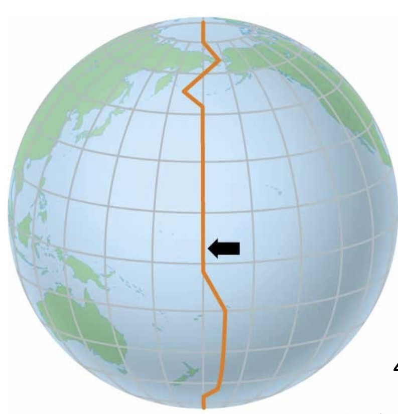
defined as 0 degree longitude line, which runs through greenwich, England.
starting point for longitude and divides earth into eastern and western hemispheres
crucial for navigation and mapping
What is the prime meridian?
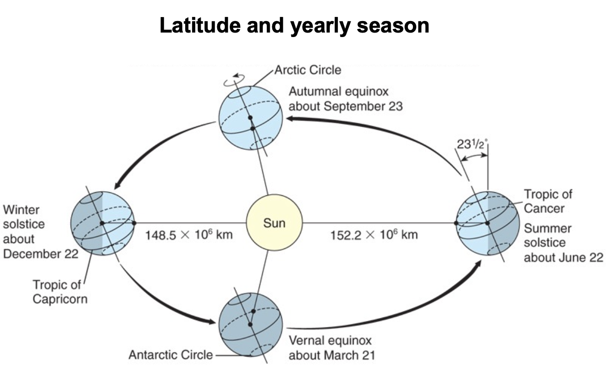
northernmost latitude (23.5 degrees North) at which sun can appear directly overhead at noon. this occurs during june solstice
regions along tropic of cancer often have rich biodiversity
what is the Tropic of Cancer?
On June 21, the Sun never sets at latitudes above the Arctic circle.
Latitudes are imaginary lines that encircle the globe horizontally, some of them are defined by specific features. What feature defines the Arctic and Antarctic circles?
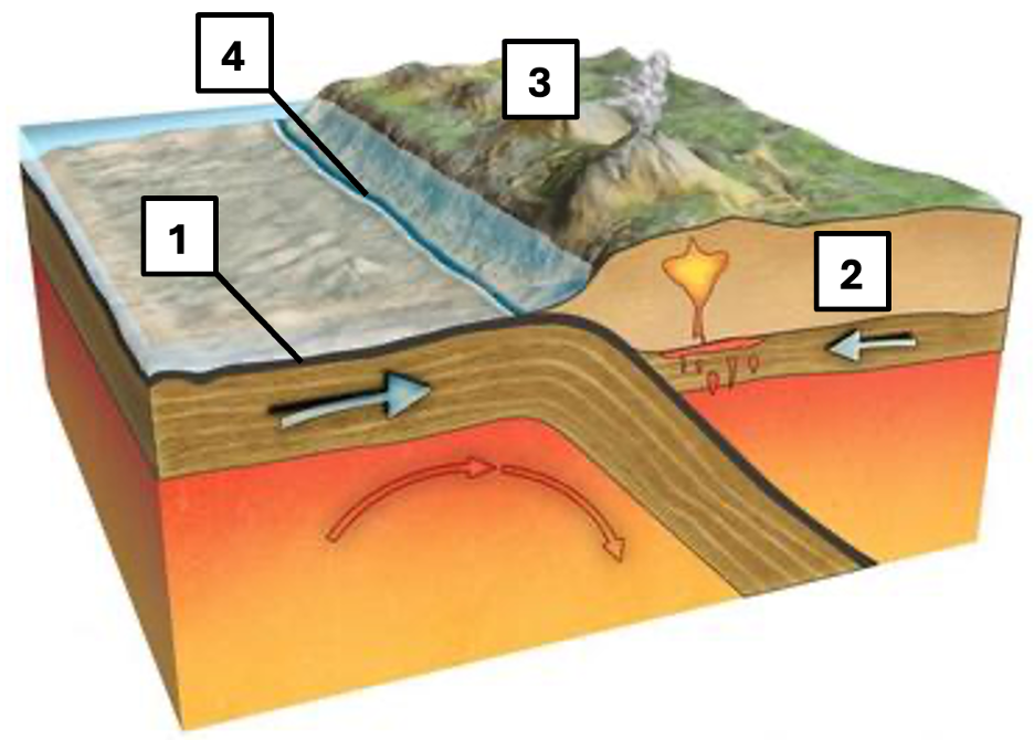
Convergent boundary; 1- Oceanic crust; 2- Continental crust; 3- Volcanic mountain range; 4- Deep-sea trench
This image depicts a specific movement of two types of lithospheric crust. Please select the correct labels for the numbered features and indicate what type of boundary is depicted.
An equal amount of incoming solar radiation is dispersed over a larger surface area at the poles than at the equator.
What is the reason why Earth's poles are so cold?
all of the incoming radiation
Let's assume Earth's average temperature is a constant 15°C, i.e., temperature is at steady state. How much of the incoming solar radiation would have to be reradiated back to space to maintain that temperature?
The Coriolis effect is of higher magnitude at higher latitudes.
There would still be a Coriolis effect on a flat Earth that was spinning like a frisbee (i.e. observers standing on this flat Earth would perceive objects propelled in a straight line as moving along a curve).
The Coriolis effect is strong enough to impact large-scale oceanic and atmospheric circulation.
The Coriolis effect deflects objects to the right in the northern hemisphere, and to the left in the southern hemisphere.
what are some facts about the coralis effect?
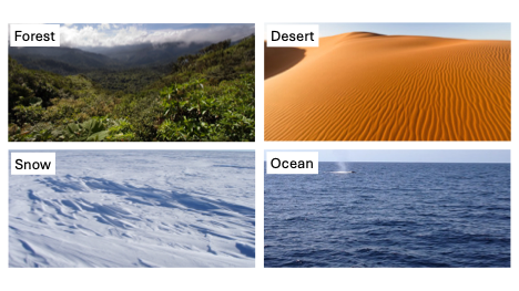
Snow, desert, forest, ocean
The albedo of a surface describes its reflectivity. Please rank these surfaces from highest to lowest albedo.
more, lower, rise
Please fill in the blanks: Warm air holds _____ water vapor, and water vapor has _____ density than air. This causes the warm air to _____, influencing both weather and regional climate.
the presence of colder surface waters near western coastlines
A consequence of upwelling is __________.
high pressure to low pressure
Winds primarily move from areas of __________.
density differences due to temperature and salinity
The thermohaline circulation is primarily driven by __________.
Counterclockwise around a center of low pressure
In the Northern Hemisphere, winds around a hurricane circulate:
Water has a high specific heat capacity, so it takes more energy to heat it up than land
Land tends to change temperature faster than the ocean primarily because:
The Gulf Stream is a western boundary current
The Gulf Stream is deep and travels fast along the east coast of the United States.
The Gulf Stream brings warm water north from the tropics
Facts about the Gulf Stream?
In the open ocean, a wind-driven wave reaches about half as deep under the surface as it is long
Waves can be approximated mathematically. What determines the depth of a wave?
shallow-water, long, always
Please complete the following sentence: Tsunamis are _____________ waves because their _______ wavelength means their height and direction of travel are ________ affected by seafloor topography.
When Earth, Moon, and Sun are aligned on a straight line.
Where in the ocean or when do we find the highest tides?
process where deep, cold, nutrient-rich water rises to the surface of the ocean
often occurs along coastlines and is due to factors such as wind patterns and earth’s rotation
crucial to marine ecosystems because it supposrts phytoplankton growth
areas of upwelling typically associated with high productivity and biodiversity
What is upwelling?
process where surface water sinks into the ocean’s depth
typically occurs in regions where winds push water away from coast or where water becomes denser due to cooling or increaased salinity
plays crucial role in ocean’s circulation and nutrient distribution
important for transporting ocean-rich surface water to deeper layers, which supports marine life in those environments
What is downwelling?
matching glacial deposits
Mountain ranges comparable in age and structure appear on both sides of the Atlantic
Mesosaurus and other animals could not have crossed the ocean but their fossils appear in 16 South America and Africa
evidents of the supercontinent?
earth’s magnetic field has reversed polarity many times. these reversals are recorded in ocean floor rocks (basaltic lavas in mid-ocean ridges) when the magma rises and solidifies at the ridges, the minerals align with current magnetic field. new lava records info.
seafloor spreading occurs at mid-ocean ridge where tectonic plates move apart. new oceanic crust is formed when the plates separate and magma rises up from the mantle. this allows us to stufy age of seafloor with the distance from the mid ocean ride
explain the magnetic patterns and their relation to seaflorr spreading and age of seafloor
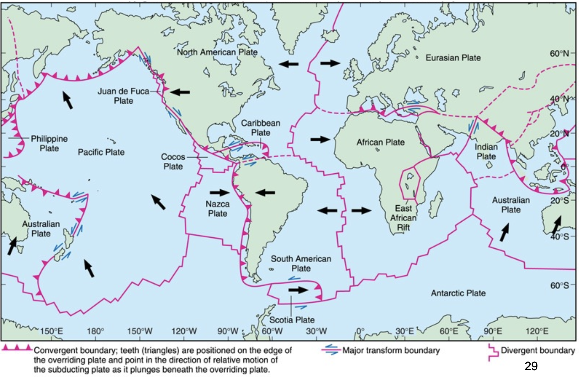
plates of the lithosphere and their direction of movement
tectonic plate boundaries where 2 plates move away from each other
at the boundary, magma rises from the mantle to fill the gap, leading to the formation of new oceanic crust (typically occurs at mid ocean ridges)
results in volcanic activity and creation of underwater mountain ranges
over time can lead to development of rift valleys on land as the continental crust is pulled apart
explain divergent boundaries
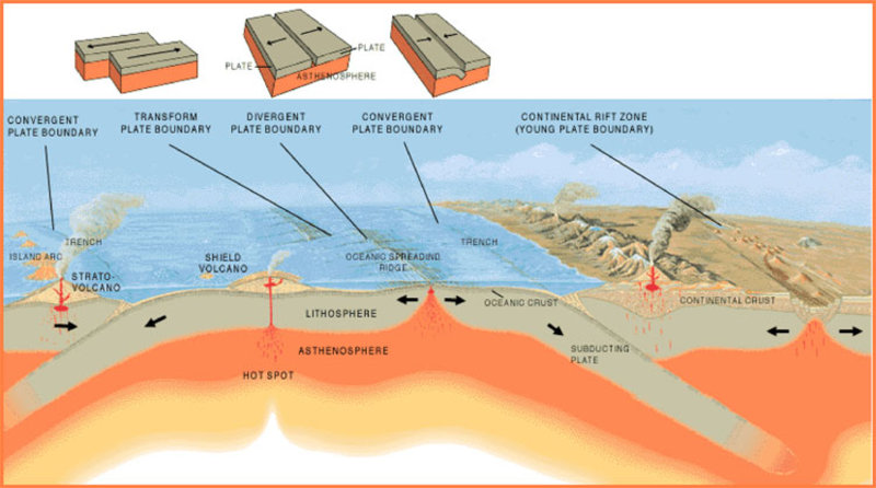
two tectonic plates move toward each other
one plate is forced beneath the other in a process called subduction
can lead to the formation of mountain ranges, deep ocean trenches, and volcanic arcs
explain convergent boundaries

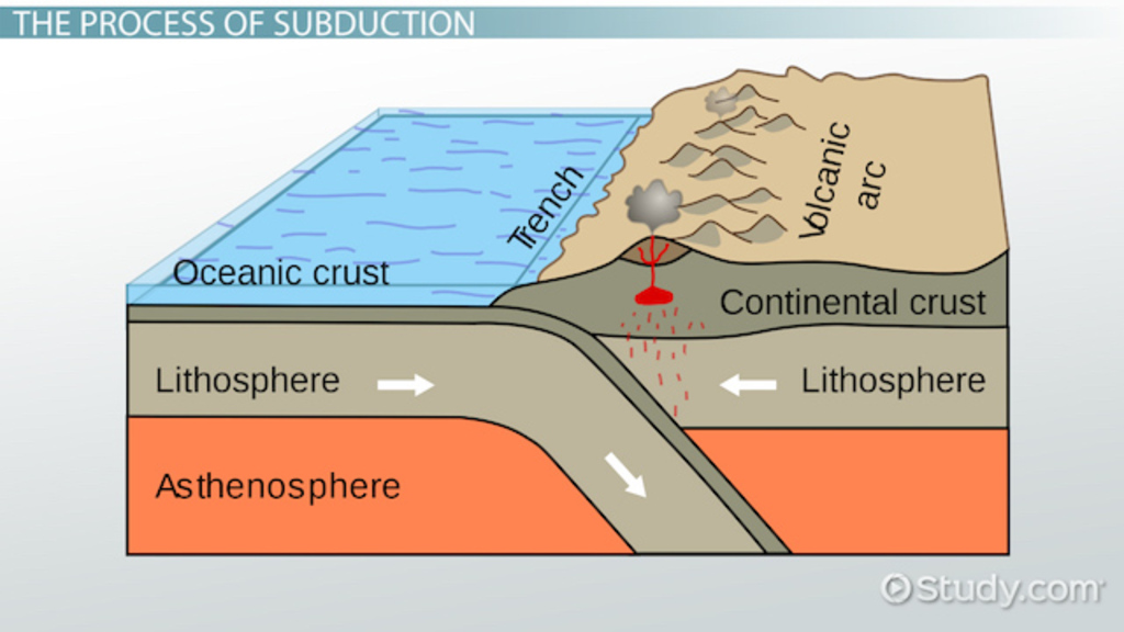
a geological process that occurs at convergent boundaries where one plate moves beneath another and sinks into the mantle due to gravitational forces
happens when an oceanic plate converges with either another oceanic plate or continental plate
subduction plate descends into mantle, forms a trench in the ocean floor and leads to volcanic activity, earthquakes, and the formation of mountain ranges
plays crucial role in recycling of earth’s crust and contributes to the dynamics of plate tectonics
explain subduction
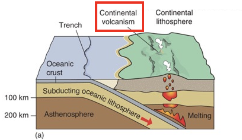
ocean on continent convergence
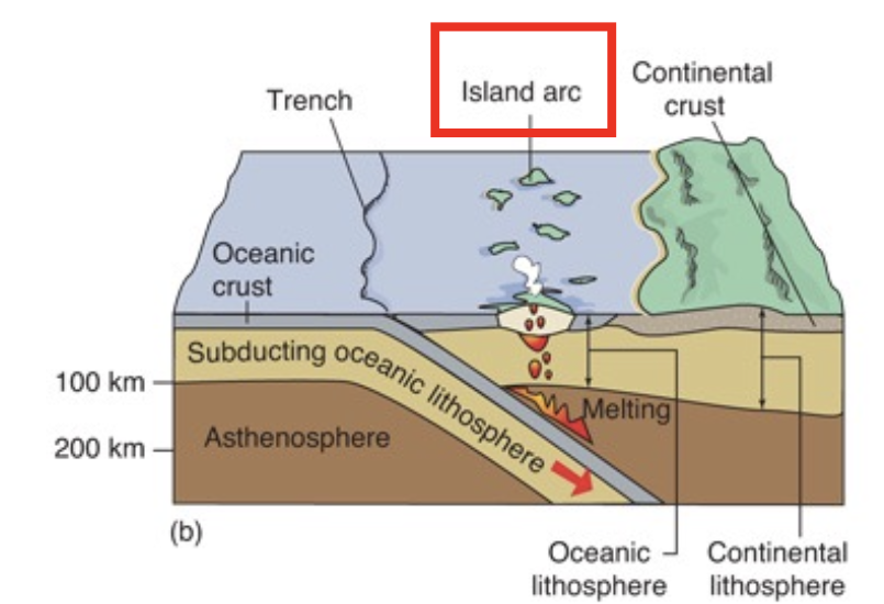
ocean on ocean convergence
YES
a change in the atmosphere affects the ocean
a change in ocean affects the atmosphere
solar energy creates winds (warm air rises), and then the winds drive surface ocean currents and waves
are atmosphere and ocean an interdependent (connected) system?
equatorial regions
because of uneven solar heating, what regions recieve more heat?
polar regions
because of uneven solar heating, what regions recieve less heat?
on this day, the sun never sets north of the Arctic circle and never rises south of the Antartic circle
summer solstice

On this day, the sun never rises north of the Arctic Circle and never sets south of the Antarctic Circle
winter solstice
from regions of high pressure to low pressure
how does wind always move?
YES
does cool, dry, dense air have higher surface pressure than warm, moist, less dense air
YES
do winds redistribute heat over Earth’s surface and produce waves and currents in the ocean?
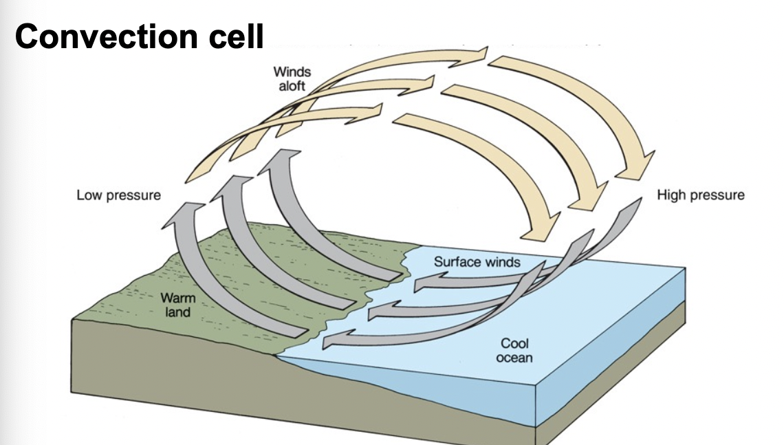
warm moist air (less dense) rises
cool dry air (more dense) sinks
What is a convection cell?
land because it requires less change in energy to change the temperature
what has a lower specific heat capacity: land or ocean?
high latitudes (because of albedo of ice and large solar footprint)
where is more heat lost than gained?
low latitudes (excess heat is distributed to high latitudes through ocean currents and atmospheric transport)
where is more heat gained than lost?
the apparent deflection of objects from a straight path if the objects are viewed from a rotating frame of reference?
what is the coriolis effect?
air parcel moving from low to high latitudes in the North Hemisphere will be deflected to the right of the direction of the air motion
an air parcel moving in the South Hemisphere will be deflected to the left of the direction of the air motion
main takeaway from coriolis effect (direction wise)?
the magnitude of the coriolis effect increases with increasing latitude and decreases with the north/southward speed of the moving object
magnitude of coriolis effect?
clockwise
the Eastern US recieves warm moist air from the low latitudes in the summer
what direction does the wind around a high pressure cell in the North Hemisphere flow?
counter-clockwise
the Eastern US recieves dry, cold air from the high latitudes in the winter
what direction does the wind around a low-pressure cell in the North Hemisphere flow?
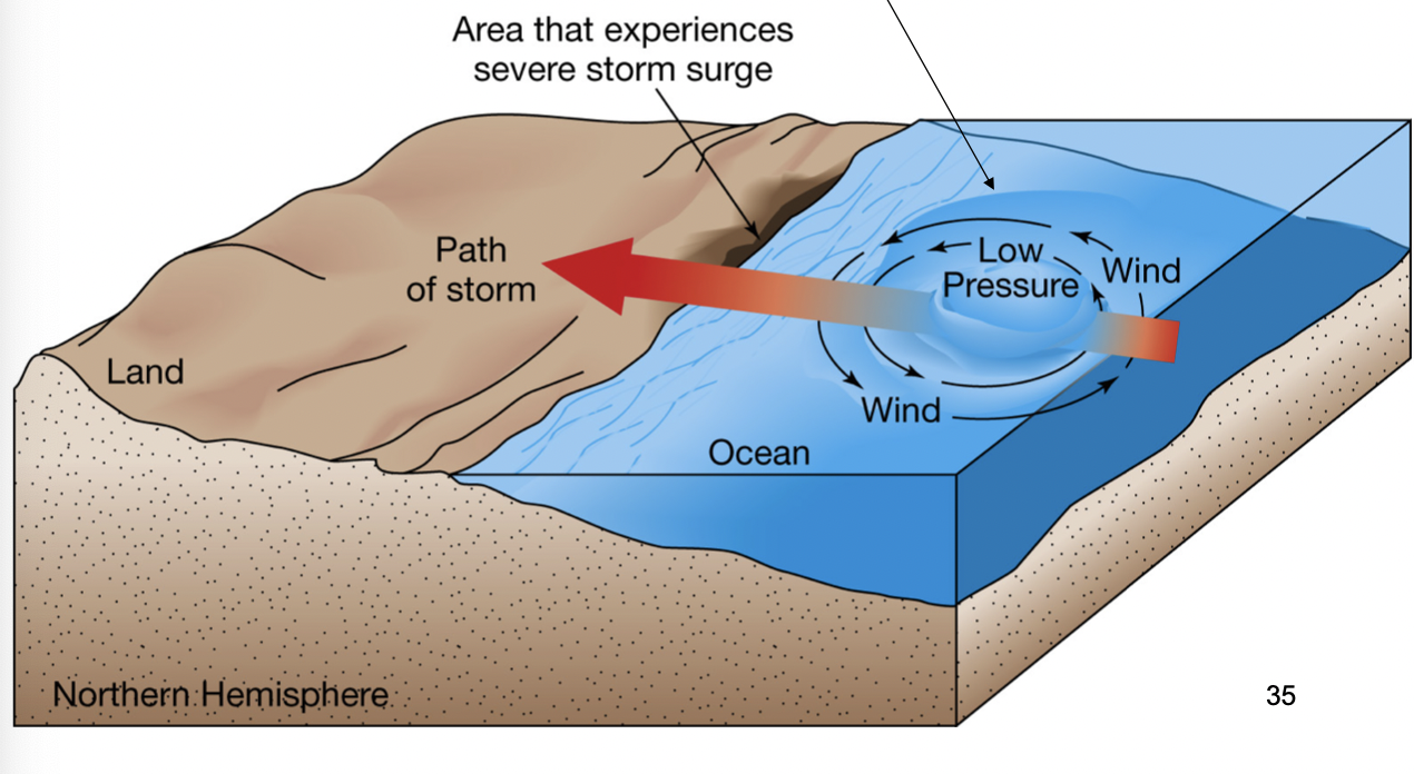
a pile of water that forms because of the lower pressure
water is also pushed by winds to the leading NW edge of the storm
what is a storm surge?
large rotating masses of tropical low pressure
strong winds, torrential rain
classifed by maximum sustained wind speed > 74 mph
what are tropical cyclones (hurricanes)?
east to west
what direction do hurricanes ride the trade winds?
the evaporation over warm water
heat energy liberated from the condensing vapor increase the velocity
what are hurricanes fed by?
when they move over cold water or land
what makes hurricanes run out of energy?
the top 150 m (described as surface ocean)
what layer of ocean is moved by winds?
study the gyres
surface ocean currents
because there is little friction between water and Earth’s surface
why is moving water deflected by the Coriolis effect?
Ekman transport
what is the dragging of waters by wind called?
wind driven surface water pushes on water below it
next deepest layer moves more slowly than surface layer and is deflected to the right (NH) or left (SH) of the surface-layer direction
average net flow of the entire spiral is at a right angle to the direction of the wind
factors of ekman spiral?
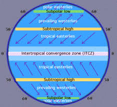
meet where temperature is highest and air pressure is lowest (this location is located slightly north of geographical equator and is called the Intertopical Convergence Zone)
trade winds
we have gyres
because we have continents…
clockwise in NH
anti-clockwise in SH
what is the direction of the gyres in the NH and SH
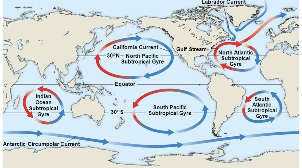
subtropical gyres
what gyres are areas of downwelling and low productivity?
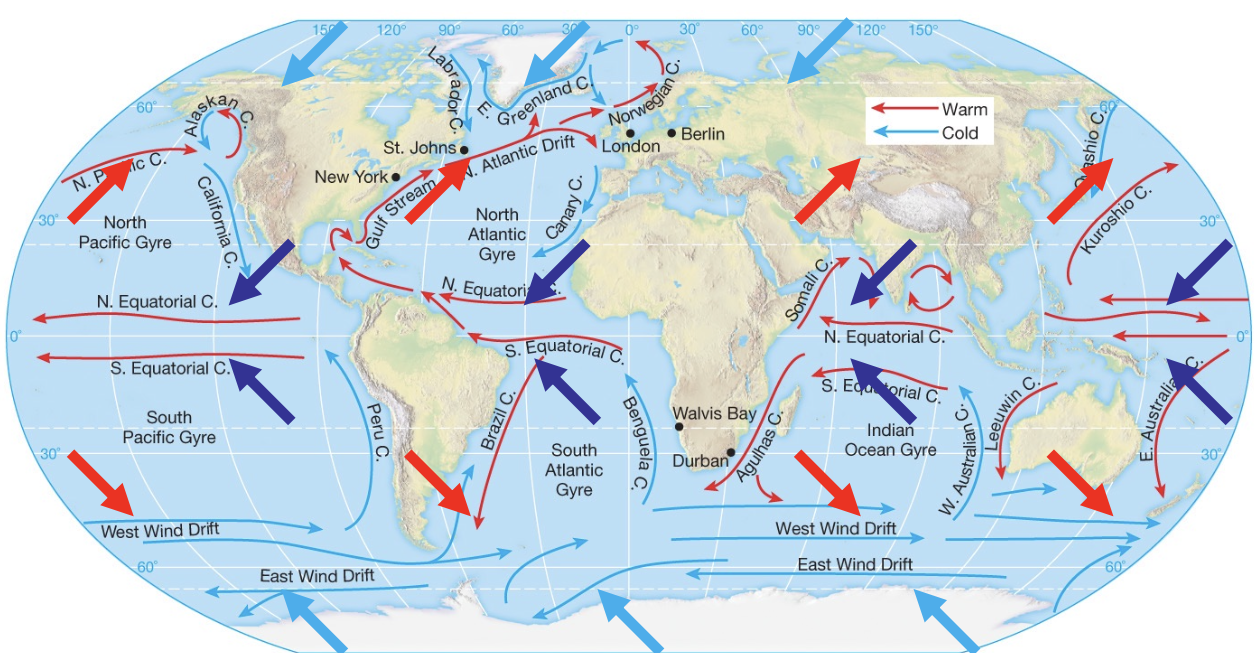
they help to redistribute warm water to the poles and cold water to the equator
what do surface ocean currents help do?
clockwise
What direction do gyres flow in the North Hemisphere?
counterclockwise
What direction do gyres flow in the South Hemisphere?
More straight flowing lines because there is not a strong coriolis effect there
What pattern are currents along the equator?
towards the poles
Where do surface currents generally move warm waters?
towards the equator
where do surface currents generally move cold water?
major global-scale system of oceanic cirulation driven primarily by differences in water density, which are controlled by temperature (thermal) and salinity (halide) variations
what is thermohaline circulation?
a system which transports warm surface waters from the equator towards the poles, where they cool and sink. the cool dense water then flows back towards the equator in deeper ocean layers
what is the global conveyor belt system?
the western side (these currents are known as the western boundary currents)
what side of the ocean basin are surface ocean currents are faster, narrowe, and deeper?
find the salinity ppt in units
make sure both the amount of water removed and the initial amount of water are in the same unit
find the amount of remaining water
add the salinity amount to the water remaining amount
divide the number you got from step 4 by 1,000 if in ppt
woohoo, you did it!
how to find salinity of a solution after evaporation mathematically?
the high latitudes
where do western boundary currents deliver heat to?
the low latitudes
where do eastern boundary currents return cold water to?
density gradients: denser water sinks below less dense water
what is deep ocean circulation driven by?
the global ocean conveyor connects to
wind-driven surface circulation
connects to the thermohaline deep circulation
how does continuity ensure that the flow is closed
evaporation and ice formation
what increases salinity?
river inflow, rain, and melting
what decreases salinity?
as density increases, salinity increases, and temperature decreases
what is the relation between density, salinity, and temperature?
density increases as pressure increases
what is the relation between pressure and density?
the density of the mixed waters will be denser than either of the original water types and it will sink
if two waters with the same density but different temperatures and salinities mix how will the density be affected?
refers to a vertical zone in the ocean where there is a rapid change in salinity with depth.
what is the halocline?
refers to a layer in the ocean where there’s a rapid change in water density with depth (primarily caused by changes in temp or salinity)
what is the pycnocline?
refers to the layer in the ocean where water temperature decreases rapidly with increasing depth.
what is the thermocline?
no because the surface waters there are too fresh which makes them less dense and prevents them from sinking to form deep water
does deep water formation occur in the north pacific?
yes because these regions have cold, salty waters that become dense enough to sink
high salinity and cold temperatures from ice formation and evaporation increase water density
does deep water formation occur in the North Atlantic and southern ocean?
occurs when surface waters in certain regions of the ocean become dense enough to sink into deep ocean
density increase of surface water occyrs because of cooling and an increase in salinity usually due to evaporation or sea ice formation
predominantly occurs in areas of high latitude
what is deep water formation?
½ of the wavelength
what is the equation for the depth of a wave?
the verticle distance from top of crest to bottom of trough
what is the wave height?
the time required for 2 sccessive troughs to pass a point in space
what is the period of a wave?
as wind speed increases, wave height and wavelength increase
what is the relationship between wind speed, wave height, and wavelength?
it is equal to the ratio of wavelength/period
how to calculate wave speed?