Geography #1: Rivers
1/59
Earn XP
Description and Tags
Case Study: • The opportunities presented by a river or rivers, the associated hazards and their management Printed Paper Indus River Valley
Name | Mastery | Learn | Test | Matching | Spaced | Call with Kai |
|---|
No analytics yet
Send a link to your students to track their progress
60 Terms
What are the main processes that happen in the Hydrological cycle (drainage basin)?
Precipitation, Infiltration, Percolation, Surface runoff, Throughflow, Groundwater flow, Evaporation, Transpiration, River discharge

What is evaporation?
The change of water from a liquid to a gas (water vapor) due to heat from the sun.
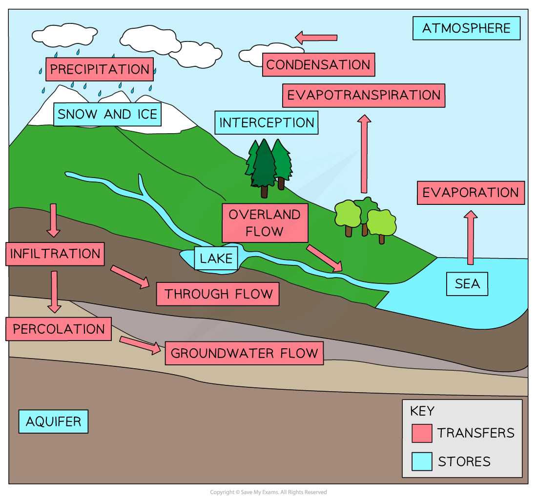
What is condensation?
When water cools and changes from water vapour into a liquid (water droplets), forming clouds.

What is transpiration?
When plants release water vapor from their leaves.

What is evapotranspiration?
The combined transfer of water vapor from the Earth's surface and plants.

What is preciptation?
The transfer of water from the atmosphere to the Earth's surface in the form of hail, sleet, snow or rain.

What is overland flow?
Any water flowing across the Earth's surface.

What is Infiltration?
When water moves down from the surface into the soil.

What is Percolation?
The transfer of water down into rocks and aquifers.
What is Through flow?
The movement of water through the soil between the groundwater store (water table) and the surface.

What is Groundwater flow?
The flow of water through rock.
What is erosion?
When material is removed from the riverbed and banks.

What is hydraulic action?
The force of the river against the banks. Air becomes compressed within cracks and crevices, weakening the banks.

What is abrasion (corrasion) ?
When materials carried by the river scrape away the banks and bed, loosening material.
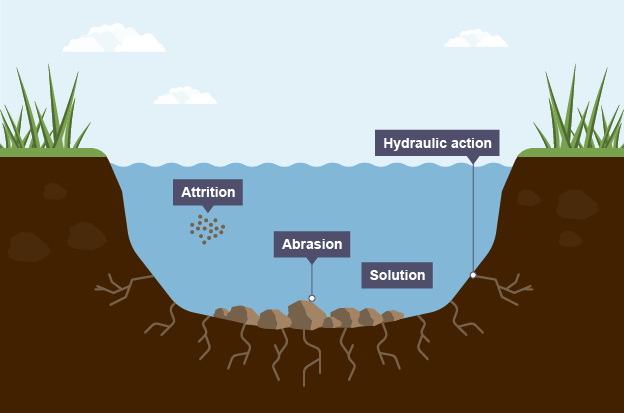
What is Attrition?
When rocks carried by the river collide, breaking into smaller, smoother pieces.

What is solution?
When soluble particles are dissolved by the river.
What are the 4 erosional processes that change the shape of the river channel?
Hydraulic action, Corrasion (Abrasion), Attrition, & Solution.
What is transportation?
The movement of material further downstream.
What are the 4 processes of transportation?
Traction, Saltation, Suspension, & Solution

What is traction?
Large rocks rolled along the riverbed during high energy times.

What is saltation?
The bouncing movement of rocks and pebbles along the riverbed when they are too heavy to be carried far.

What is suspension?
Smaller material that is light enough to be carried along.
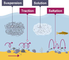
What is solution for transportation?
Very small material that is dissolved and can be transported during low energy.
What is deposition?
When a river does not have enough energy to carry materials, leading to the dropping of those materials.
When does deposition occur in a river?
Deposition occurs when river energy is low, when the volume of water decreases, or when the river enters a sea or lake and spreads out.

What landforms can erosion create in a river course?
Erosion can create rapids, potholes, and waterfalls.

What characterizes the upper course of a river?
It is the start of the river at higher altitude, with a small channel and vertical erosion due to gravity.

What happens in the middle course of a river?
Tributaries join the channel, increasing the water volume carried by the river.

What defines the lower course of a river?
It is where the river meets the sea, being wide and deep, with lateral erosion and deposition.

What are the three sections of a river?
The upper, middle, and lower courses.

What do the three courses of a river form?
The long profile of a river.

Where are waterfalls and rapids found?
In the upper course of rivers.

Where is deposition most common in a river?
Deposition is common in the lower course of the river, where it meets the sea.

What landforms are there in the upper course of a river?
Waterfalls & Gorges, Potholes, & Rapids

What landforms are there in the middle course of a river?
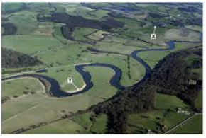
Meanders, Oxbow lakes, & Flood plains
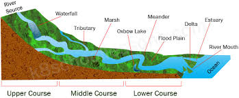
What landforms are there in the lower course of a river?
Floodplains, deltas, & eustaries

What are the characteristics of the upper course of a river?
It has a steep gradient, low velocity, vertical erosion, large bedload, and a narrow & shallow channel.
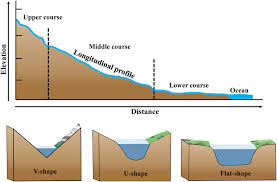
What are the characteristics of the middle course of a river?
They have a more gentle gradient, faster velocity, lateral erosion, and a wider & deeper channel.

What are the characteristics of the lower course of a river?
They have a flat gradient, the fastest velocity, lateral erosion, and the widest and the deepest channel.
As a river flows from source to mouth, its characteristics change. What are they?
The width and depth increases downstream. The river velocity increases downstream due to a larger volume of water and smoother channel. The river discharge increases downstream as more tributaries join and surface runoff adds water.
What are the characteristics of a drainage basin?
Watershed, tributary, and confluence.
What is a watershed?
This is the boundary between drainage basins.
What is a tributary?
A stream or river flowing into a larger stream or river.
What is a confluence?
The place where two or more streams/rivers meet.
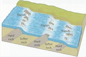
How do rapids form?
When water flows over hard and soft bands of rock, eroding the soft rock more quickly, leaving the hard rock sticking up in a ridge.
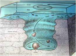
How do potholes form?
When water moves in circles (turbulence), it spins rocks around. These rocks scrape against the riverbed, wearing it down. Over time, this scraping creates holes in the riverbed, called potholes.
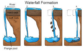
How does a waterfall form?
A waterfall forms when a river flows over hard rock with soft rock beneath it. The soft rock wears away faster, creating a drop. The water makes a deep pool at the bottom and undercuts the hard rock. Eventually, the hard rock breaks and falls, making the waterfall move back. This keeps happening, and over time, a gorge is left behind.
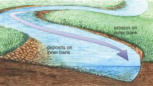
How do river meanders form?
As a river flows, it erodes the outer bank and deposits sediment on the inner bank. Over time, this makes the river bend more, creating a snake-like shape. Faster water on the outer bank causes more erosion, while slower water on the inner bank builds up sediment, shaping the river further.
How are river meanders essentially formed?
They are formed through a combination of erosion and deposition by the flowing water of a river.
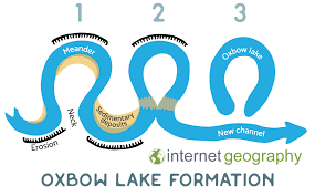
How does an oxbow lake form?
The river meanders across the valley, bending from side to side. It flows faster on outside bends, eroding them, and slowly on inside bends, depositing material. Erosion and deposition narrow the meander's neck. During floods, the river cuts through, abandoning the meander eventually drying up.
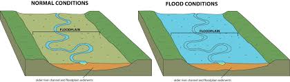
How are floodplains formed?
When a river overflows its banks, depositing sediment on the surrounding land during high flow. Over time this creates a flat surface that can support vegetation & ecological habitats.
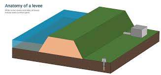
What is a levee?
A natural embankment that forms adjacent to a river.
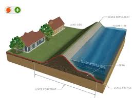
How are levees formed?
During floods the river overflows its banks and spreads out over the land, as water slows down, the river deposits the heaviest sediment first, over time forming a ridge.
Where are deltas formed?
The lower course, where the river meets the sea at its mouth.
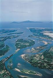
How is a delta formed?
A delta forms when a river reaches the sea or a lake and slows down as there is no limiting channel. This causes deposition as materials such as rocks, sands, or silt is dropped and carried upstream. Over time, this buildup creates small channels, spreading the river into different paths.
What are the hazards of flooding & erosion?
Flood waters may increase the spread of water-related diseases such as chlorea.
Deaths & injuries as floodplains are often densely populated due to the fertile soils.
Bridges and transport routes may be damaged or destroyed by the flood waters.
Erosion of the river banks leads to the loss of farmland, housing and transport routes.
Destruction of crops.
Increased insurance costs .
Lower house prices.
What are some of the opportunities of living on a Flood Plain, Delta, or near a river?
Fertile soil – floodplains and deltas have rich, alluvial soil ideal for farming.
Water supply – rivers provide water for drinking, irrigation, and daily use.
Transport – rivers are natural routes for boats and trade.
Fishing – provides food and jobs.
Flat land – easier to build homes, roads, and farms.
Hydroelectric power (HEP) – rivers can be used to generate electricity.
Leisure & Tourism – river landscapes attract tourists, supporting local economies.
What are some things that cause flooding?
Both natural and human factors. Heavy rainfall, snowmelt, deforestation & urbanization, relief, rock type, soil, climate change, blocked drainage or steep slopes, dam failure, and tropical storms.
What are some ways to manage flooding?
Dams and reservoirs which enable the amount of discharge downstream to be controlled
Embankments or levées increase the capacity of the river
Straightened channels mean that the river flows more quickly past vulnerable areas, reducing the risk of flooding
Flood relief channels allow some water to flow out of the main channel, reducing the discharge
Spillways or overflow channels: these take excess water away from the main channel
River restoration supports the river by restoring it to its original regime—putting meanders back in, stabilising banks and connecting to flood plains
Wetland conservation these areas provide somewhere for excess water to go and slow the flow of floodwater
Catchment management plans assess the risk of flooding in an area and outline how this will be managed
Floodplain zoning means that only certain land uses are allowed on the floodplain, reducing the risk
Afforestation involves the planting of vegetation and trees to increase interception and infiltration
What is a drainage basin?
The area of land drained by a river and its tributaries. All the rainfall that falls in this area eventually flows into the main river.