Task H. Navigation & Radar Services (MASTER COPY)
1/67
Earn XP
Description and Tags
https://www.faa.gov/about/office_org/headquarters_offices/ato/service_units/techops/navservices/gbng/vormon#:~:text=The%20Very%20High%20Frequency%20Omni,Positioning%20System%20(GPS)%20signal
Name | Mastery | Learn | Test | Matching | Spaced | Call with Kai |
|---|
No analytics yet
Send a link to your students to track their progress
68 Terms
What do Antennas do?
Converts the electrical current of a signal into a radio wave to travel through space to a receiving antenna which it is then converted back to electrical current to be read by the device
What are the 3 different types of radio waves?
Ground Waves
Sky Waves
Space Waves
What are Ground Waves?
Lower frequency waves that travel closer to the earth
Follows earths curvature
The lower the frequency of the wave, the father it can travel
What are Sky Waves?
Higher frequency waves that don't follow earth's curvature
Waves are “refracted/ Bent” by the Ionosphere & sent back down to earth
Its a way to send messages across the ocean using very little PWR
50 to 100 watts usually
What are Space Waves?
Consists of VHF or higher waves that do not refract or bend
They go right through the ionosphere
This allows for navigation from space
Any objects between the transmitter & receiver may block the signal
Line need line of sight
What is an NDB?
Non-Directional Beacon (NDB)
One of the OLDEST Nav Aids
Very few still operate in the US
It is a ground based Am radio that transmits in all directions
They operate on frequency range of 190 - 535 KHz (Low to Medium Wave/ Band)
How do we use an NDB to naviagate?
Homing & Tracking
Homing: This involves flying directly towards the NDB adjusting the heading as needed to keep the needle centered (Maintaining a 0° relative bearing)
This method does not account for wind correction & may be blown off course by crosswinds
Tracking: This method involves maintaining a constant bearing to the NDB, which may not be the most direct path.
Pilots apply wind correction to their heading to maintain a desired track to or from the station. This ensures that the aircraft follows a more precise and efficient path, compensating for any crosswinds that might push the aircraft off course
What equipment do we use with an NDB?
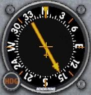
ADF (Automatic Direction Finder)
MH (Magnetic Heading) + RB (Relative Bearing) = MB (Magnetic Bearing)
What does an NDB look like on a Sectional Chart & what does its info box contain?
The magenta circle & info box denote an NDB
Info Box contains
NDB name
Frequency
ID
Morse Code Identifier

What are the 4 classes of NDB?
Compass Locator
Just over 25 watts
Range of 15 NM
Medium-High
25 - 50 Watts
Range of 25 NM
High
50 watts - 2 kW
Range of 50 NM
High-High
Less than 2 kW
Range of 75 NM
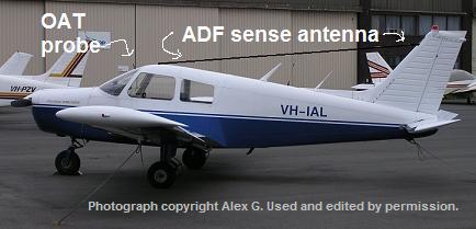
What are the 2 antennas used for receiving NDB signals?
Loop Antenna
Sense Antenna
What is a Loop Antenna & how does it work?
Directional antenna with 1 or more loops
If radio waves hit the loop (besides perpendicular) a voltage will be induced over the antenna
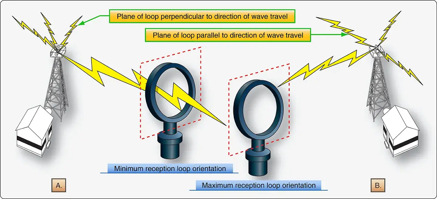
What is a Sense Antenna & how does it work?
It Is able to use the waves provided by the loop antenna to determine which one is the correct bearing & remove ambiguity of other signals
What are some NDB & ADF errors?
Thunderstorm effect
ADF needle will temporarily deflect towards lighting strikes
Night effect
NDB signals can be refracted by the ionosphere & return as sky waves
Most prevalent during dawn & dusk hours
Mountains
They can reflect the NDB signal
Coastal effect
The ADF needle will slightly bend towards the coast line if crossing at an angle
Hearing any static in the Morse code or ADF needle acting erratically usually means there are errors
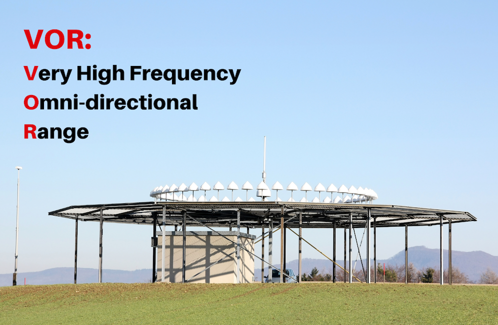
What is a VOR?
Very High Frequency Omni-directional Range (VOR)
Still widely in use and much more common
They Operate in the frequency band of 108 - 117.95 MHz (Space Waves)
Requires line of sight
Oriented to Magnetic North
Signal is sent out in every direction
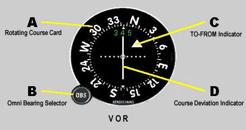
What are the 3 main parts to a VOR Indicator?
Course Deflection Indicator (CDI)
How far off center from the course you are in Degrees
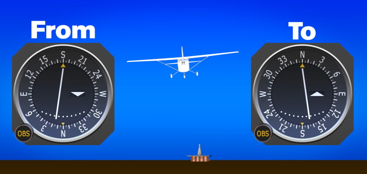
To/ From Indicator
If you are flying TO or FROM the set radial
Omni Bearing Selector (OBS)
The OBS knob is used to set the course or radial you'd like to reference
Course VS Radial
Course: Directed towards the VOR station
When flying towards a station
Radial: Directed away from the VOR station
Flying away from a station
Explain how Radials/From & Course/To Indications work & are related?
The Station does not know what direction or heading the aircraft is flying
EXAMPLE: You are south of the VOR flying northbound, you could tune into the 180 Radial w/ FROM indication, or you could tune a 360 course with a TO indication
Watchout for reverse sensing
HSI automatically compensate for this
What is the Cone of Confusion?
Area above the VOR where the airplane does not get a clear or any signal
TO/ FROM indicator will swap to “Off position”
What is a DME?
Distance Measuring Equipment (DME)
This will tell you how far from the VOR you are
It gives it in Slant range, not across the ground distance
Operates in the UHF between 962 - 1213 MHz
Emits a morse code signal every 30 seconds to indicate it is working
It has a range of 199 NM but only serves the closest 100 aircraft
Subject to line of sight rules
How does the DME work?
The aircraft DME sends a signal to the station which then sends the signal back. It measures the time it took for the signals trip to complete then converts it to distance
The distance given is the “Slant Range Distance”
The distance shown is the exact distance to the station NOT the distance across the ground
Effect is worse at higher altitudes
How to use 2 different VORs to find your location?
Also Called triangulation
Pick 2 Nearby VORs and tune them in,
Center both VORs w/ FROM Flags to get the Radials
Then use a sectional chart to plot the 2 lines, where they intersect is your location
Do you have to get the VOR checked, & if so how often?
You must check your VOR every 30 days for IFR Operations ONLY
Not required for VFR Operations (But still a great idea)
The maximum amount of error a VOR can have per type of check?
VOT, VOR checkpoint, Dual VOR Checkpoint,
Plus or minus 4 degrees of error
Airborne VOR Check
Plus or minus 6 degrees of error
VOR Check - VOT Signal
It's located on an airport. here's what to do:
Tune VOR to VOT signal.
Set the course selector to 0 degrees
Track indicator should be centered
The TO-FROM indicator should read FROM.
Then set the course selector to 180 degrees
TO-FROM indicator should read TO
Track bar should be centered.
The maximum indicated bearing error is plus or minus 4 degrees.
Not all airports have this, check supplements
VOR Check - VOR Checkpoint
VOR checkpoint signs are usually located near
Taxiways
Ramps
Runup area
The signs indicate the exact point on the airport where there is sufficient signal strength from a VOR to check the aircraft's VOR receiver against the radial designated on the sign.
To use a VOR checkpoint, simply follow the instructions on the sign.
The maximum indicated bearing error is plus or minus 4 degrees
VOR Check - Dual VOR Checkpoint
Easiest way to check as long as you have 2 VOR receivers.
To check dual VOR receivers against one another:
Tune both NAV radios to the same VOR facility.
Center the needles of each VOR receiver with a "TO" indication.
Note the indicated bearings to the station from each receiver
The maximum permissible variation between the two indicated bearings is 4 degrees.
VOR Check - Airborne VOR Check
VOR equipment can also be checked for accuracy in flight.
To accomplish an airborne VOR check:
Select a VOR radial that lies along the centerline of an established VOR airway.
Select a prominent ground point along the selected radial preferably more than 20 nautical miles from the VOR ground facility and maneuver the aircraft directly over the point at a reasonably low altitude.
Note the VOR bearing indicated by the receiver when over the ground point.
The maximum indicated bearing error is plus or minus 6 degrees.
What info is required for the VOR check log?
Date of the check
Location of the check
Bearing errors encountered
Pilots signature in
Aircraft logbook or other record
How to know if a VOR is operational?
They transmit 3 letter identifiers in Morse Code
No need to continuously monitor the frequency
If the station is inoperative, the TO/ FROM flag will show “Off” with no Morse Code signal transmitted
Some new GPS systems can identify the VOR for you
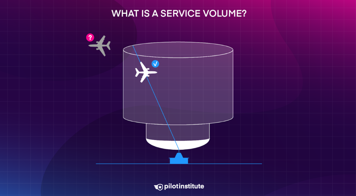
What is a Service Volume?
Three-dimensional area where aircraft can reliably pick up the NAVAID’s signal, free from interference.
When using a VOR within its service volume, the FAA ensures navigational accuracy, accounting for standard errors.
What are Legacy VOR Service Volumes?
All start @ 1,000ft AGL
Terminal
Usually co-located with airports and are typically used for approaches.
Low
High
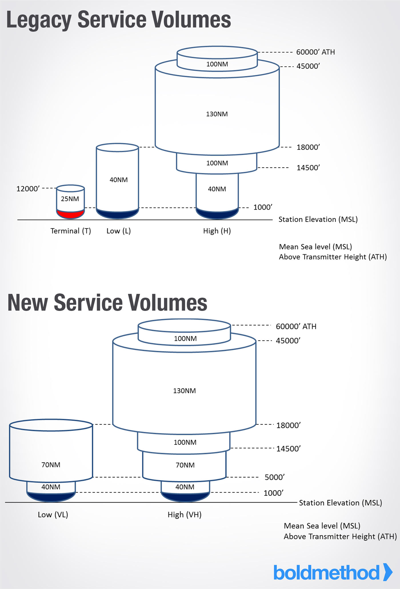
What are New Service Volumes?
Starts at 1,000' ft AGL
VOR Low
VOR High

What does a VOR & info box look like on a sectional chart?
A compass rose is shown for help plotting Radials/ Courses
Like NDBs, has a info box with:
Name
Frequency
Morse code identifier
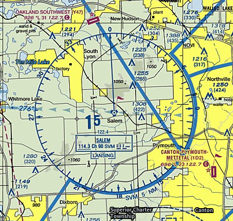
What are Victor Airways?
Predefined Low Altitude Routes pilots can use to navigate along
Shown on VFR sectionals & Low Altitude IFR enroute charts
Extend from 1,200’ AGL up to but not including FL180
4 NM width each side of the course
8 NM Total
What are the different types of VOR?
VOR
VOR DME
VORTAC
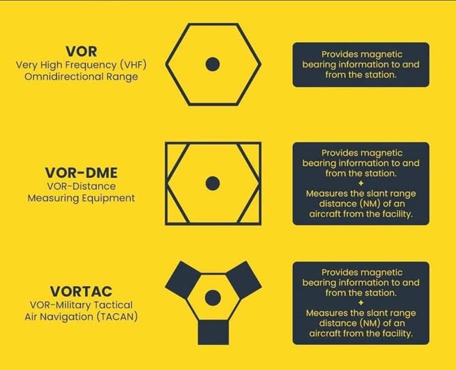

VOR (VHF Omnidirectional Range)
Radio navigation system that allows pilots to determine their position relative to the VOR station.
Transmits a 360-degree signal that helps pilots navigate along specific Radials & Courses

VOR-DME (VOR with Distance Measuring Equipment)
Combines VOR functionality with DME to provide distance info
Pilots can determine their bearing & how far they are from the VOR station
Enhances situational awareness.
Useful for precise navigation and approach procedures.

VORTAC (VOR Tactical Air Navigation)
Integrates both VOR and DME functions with a TACAN system, primarily for military use.
Provides the same info as VOR-DME but also offers a compatible format for military aircraft.
Often used in joint operations, allowing both civilian & military pilots to utilize the same nav aids
What does GPS stand for?
Global Positioning System
USAs version of a Global Navigation Satellite System (GNSS)
Testing began in the 1970s and became fully operational in 1995
What are the 3 major elements of the GPS system?
Space Segment
Control Segment
User Segment
What makes up the Space Segment?
A constellation of 31 satellites about 11,000 NM above earth
The US Maintains 24 operational satellites at least 95% of the time
Arranged so at any time, 5 are in view to any receiver (4 are required for operation minimum)
Each satellite orbits the Earth in approximately 12 hours at speeds of 7,000 MPH
Equipped with highly stable atomic clocks and transmit a unique code/nav message
The satellites broadcast in the UHF range
Nearly unaffected by weather
Subjected to line-of-sight references
Must be above the horizon (as seen by the antenna) to be usable for navigation
What makes up the Control Segment?
Consists of a master control station, 5 monitoring stations, and 3 ground antennas
Help ensure accuracy of:
GPS positions & Atomic Clocks
Master station collects info & is able to send Updates/corrections to the satellites as they pass over the ground antennas
What makes up the User Segment?
Consists of all components associated with the GPS receiver
Range from portable, hand-held receivers to those permanently installed in the plane
The receiver utilizes the signals from the satellites to provide:
Positioning, velocity, and precise timing to the user
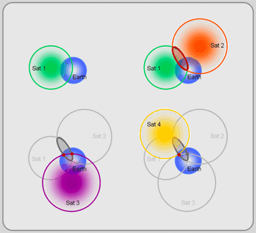
How many satellites does it take to find our position?
3 Satellites are needed to find your 2D location
latitude & longitude
4 Satellites are needed to find your 3D Location
Latitude, longitude, altitude, and time solution
5 Satellites are in view at any time, sometimes more.
If 5 or more help provide efficiency, redundancy, & backup of singal
GPS Navigation VS VOR Navigation?
For a GPS, you just input your destination and your all set
No station to tune into or verify
Course Deviation is linear, so it has the same amount of sensitivity no matter what
No need to deal with/ figure out TO/ FROM flags
Although GPS is super easy, it is never a good idea to rely on only one form of Navigation when flying
VOR is great for waypoints
Stiill in wide use across america
many IFR approaches still use VOR in some way
What is RAIM?
Random Autonomous Integrity Monitoring
It verifies the integrity of signal & info sent from the satellites to the aircraft
5 - 6 Satellites are needed to calculate RAIM
Talk about RAIM Outages, what happens with them, and how we know if we have RAIM or not?
RAIM outages happen when
There is an insufficient number of GPS satellites
There is an unsuitable Satellite geometry
On our GPS unit, it will display if we have RAIM or not by saying “RAIM not available"‘
Things to think about & know when using GPS for VFR navigation?
GPS installs can vary between full IFR setups or basic handheld receivers
Some dont even support RAIM
sometimes aircraft anntena location is far from ideal
With no RAIM & loss of signal, position errors could be as high as 300 ft off
Know your setups limitations before full use
Talk about Database Currency & things to remember with it?
Aircraft map database must be updated & current for IFR operations (AIM 1-1-1b3(b))
No requirements for VFR operations
It is always best practice to used updated databases no matter what operation is being conducted
Normal & Special use airspace dimensions may have shifted with any update.
Not having up to date data could mean you bust the airspace
What is WAAS and how does it work?
Wide Area Augmentation System
Designed to highly improve accuracy, integrity, & availability of GPS signals
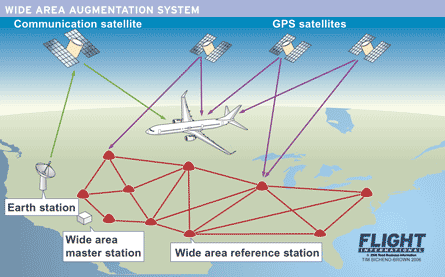
How does WAAS work?
As the initial signal is sent it is monitored by Wide Area Reference Stations.
They monitor the signal and relay the data to Wide Area Master Stations.
The Master stations compute a correction to the GPS signal which is sent to a stationary WAAS satellite via Ground up-link stations.
That correction is then sent to the original satellites

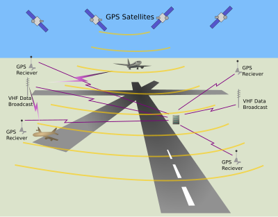
What is LAAS & how does it work?
Local Area Augmentation System
Also refereed to as GBAS
Ground Based Augmentation System
All-weather aircraft landing system based on real-time differential correction of the GPS signal.

How does LAAS work?
Local reference receivers located around the airport send data to a central location at the airport
Data is used to formulate a correction message, which is then transmitted to users via a VHF Data Link
Information is used to
Correct GPS signals
Provide ILS-style display while flying a precision approach
What are ATC Radar Services?
ATC facilities equipped with Radar to provide assistance & navigation to VFR aircraft as long as:
You can communicate w/ ATC
Are within Radar coverage
Can be Radar Identified
Some limitations of Radar services?
Based on controllers discretion
Usually if to busy or other priority events happening
Guidance info is ADVISORY ONLY
Safe flying remains with PIC
Cannot determine if flight will lead into IMC conditions from instructions given
What are some ATC services a VFR pilot could request?
Flight Following (Basic radar service)
Safety alerts, traffic advisories, limited radar vectoring (workload permitting)
TRSA Service
Radar sequencing and separation for VFR aircraft in a TRSA
Class C services
Separation between IFR/VFR and sequencing of VFR traffic to the airport
Class B services
Separation based on IFR, VFR and/or weight and sequencing VFR arrivals
What is ADS-B?
Automatic: Automatically transmits information
Dependent: Position & Velocity are derived from GPS/FMS
Surveillance: Allows 3D position and identification
Broadcast: Transmits the information to anyone with appropriate receiving equipment
Broadcasts this info every second
What is ADS-B Out?
It broadcasts GPS location, altitude, ground speed, more to ground stations/other aircraft
What is ADS-B in?
Pilots can see what controllers see in the air and on the ground
Can also provide in-flight weather
FIS-B (Flight Information Service Broadcast – available on 978 MHz UAT equipment)
Like XM weather, but more information
TIS-B (Traffic Information Service Broadcast – available to 1090ES and UAT equipment users)
Provides traffic information on all transponder-based aircraft in the vicinity of the ADS-B
IS ADS-B required?
FAR 91.225 – Effective Jan 1, 2020, ADS-B OUT is required in:
Class A, B, and C airspace (and above the ceiling of Class B and C airspace up to 10,000’ MSL)
Class E airspace at & above 10,000’ MSL, excluding at & below 2,500’ AGL
At & above 3,000’ MSL over the Gulf of America within 12 nm of the coast
ADS-B IN is voluntary
How to get a temporary ADS-B Deviation Authorization?
“ADS-B Deviation Authorization Preflight Tool” (ADAPT) must meet the following:
Must be equipped w/ operational:
transponder
altitude encoder
Submit no more than 24 hours before flight and no less than 1 hour before flight
What is a Transponder?
Automated transceiver that, upon receiving an interrogating signal from a ground-based radar system, responds with a coded signal, helping air traffic control track and identify aircraft
What are the different Modes (Models) of a transponder?
A: Transmits 4-digit code that identifies an aircraft and its position
C: Mode A + ATC can see the aircraft’s altitude
S: Transmits a variety of information to ATC & other aircraft
Unique ICAO address (assigned to each aircraft)
Heading, speed, other flight related data
Integral to TCAS (Traffic Collision Avoidance System) and ADS-B
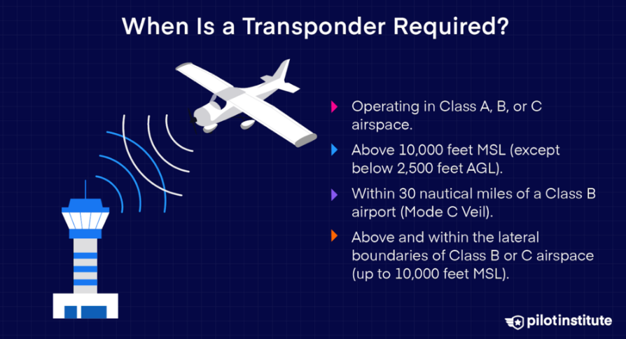
When is a transponder required?
A transponder is required only when:
In Class A, Class B, or Class C airspace.
Above 10,000 ft MSL, excluding airspace below 2,500 ft AGL
Within a Class B Mode C Vail
30 NM radius from center of Class B
Above & inside lateral boundaries of Class B or Class C airspace up to 10,000 feet MSL.
Things to remember when using EFB
Pilots are responsible for proper use of an EFB and installed avionics
Pilots may be evaluated on the use and interpretation of an EFB or installed avionics
Not required, but always maintain current EFB charts and publications
Understand the abilities and limitations of the system(s) of your aircraft
Always monitor & ensure system is doing what you intend, when you intend it
Ensure the autopilot system is properly programmed to fly off the appropriate nav source
A lack of familiarity can be a tremendous distraction in the cockpit & pull focus away from flying/scanning
Distractions to keep in mind and watch for?
Always follow: Aviate, Navigate, Communicate
Nav systems, GPS, & moving maps can take away pilots attention
Don’t be overdependent on just one Navigation system, have backup plans
If you lose Situational Awareness, Admit it, and work to regain it
Good task management procedures?
Divide attention between flying/navigating, scanning, and communicating
No one responsibility should take your full attention full more than a short period
Recognize when you are getting behind and find a way to catch up