Geography - Option A: Freshwater
1/99
There's no tags or description
Looks like no tags are added yet.
Name | Mastery | Learn | Test | Matching | Spaced | Call with Kai |
|---|
No analytics yet
Send a link to your students to track their progress
100 Terms
systems theory (open and closed systems)
systems: any set of interrelated components connected together
closed: system shut off from surrounding environment, self-contained (e.g. Earth, hydrological cycle)
open: system not self-contained, inputs of energy and matter flow into the system and outputs of energy and matter flow out of the system (e.g. city, river, car)
hydrologic cycle
the movement and interchange of water btwn sea, air, land
Water is constantly moving
transpiration
evap from plants where water vapour escapes
runoff
water flowing over land surface
infiltration
water soaking into the ground
infiltration capacity
max rate at which rain is absorbed by soil in given condition
percolation
liquid slowly passing through a filter
drainage basin/water shed
the geographic area which supplies water to the network of streams, lake, ocean
tributary streams carry water downhill and join to create a larger river
drainage divide
elevated ridge btwn 2 drainage basins
precip and evap
precip: conversion and transfer of moisture in atmosphere → land (rain/snow)
evap: conversion of liquid and solid precip to water vapour in atmosphere (energy provided by solar radiation)
overland flow
surface run-off water that flows over land’s surface when infiltration capacity reached
throughflow
water that flows through soil in natural piipes and percolines
baseflow
river discharge from groundwater that seeps into river bed
aquifers
permeable rocks that absorb water slowly (limestone, sandstone
cyrosphere
snow and ice environment
discharge (q)
volume of water passing through a cross section of a river during a given period of time (cubic m/s or cumecs)
thalwag
fastest point in a river
erosion
the breaking down and transport of sediment
hydraulic radius
ratio of cross-sectional area divided by perimeter of flow channel
Measures stream efficiency where high ratio = high efficiency and low frictional loss
abrasion, attrition, corrosion
abrasion: wearing away of bed and bank by load carried by river
attrition: wearing away of load carried by a river → smaller, rounder particles
corrosion: removal of chemical ions, rocks dissolve in acidic water
Flood plain
Area formed by deposition when river floods
Meandering
Normal behaviour of fluids and gases in motion
Levees
Raised banks at river edge formed by repeated flooding of river w/ deposition of material
(Flood/storm) hydrograph
Shows variations in a rivers discharge over a period of time
Drought and absolute drought
Drought: extended period of dry weather → extreme dryness
Absolute drought: 15 consecutive days w/o 0.2mm of rainfall
Phreatic and aeration zone
Phreatic zone: permanently saturated zone within solid rock and sediment where all pores are filled w/ water
Aeration zone: area that is seasonally wetted and seasonally dries out
Aquilude/aquifuge and aquitard
Aquifuge/aquilude: rocks that will not hold water like clay
Aquitard: layer of rock which prevents movement of water
Algal blooms
Rapid growth of algae from additional resources
Irrigation
Artificially adding water to farmland to boost plant growth
IDBM
Process of coordinating conservation, management, development of water+land
Maximize economic and social benefits from water wile preserving and restoring freshwater/resources
Wetlands and broads
Wetlands: area of land covered by shallow water or saturated by water most of the year
Broads: large, shallow sheet of freshwater - form of wetland
The drainage basin as an open system w/ inputs, outputs, flows, and stores
Flows
infiltration and percolation
Influenced by rain duration, soil moisture and porosity, slope, vegetation
Infiltrated water is chemically rich (picks up organic and minerals)
Plant roots are channels for percolation
Overland flow
When precip is greater than infiltration rate / soil is saturated
Increases when precip increases and infiltration capacity decreases (semi-arid, cultivated fields)
Through fall
Base flow
Storage
freshwater storehouses: glaciers and icesheets (cyrosphere), rivers and lakes, atmosphere, vegetation, surface, soil moisture, groundwater channel, aquifers
Saltwater storehouses: ocean

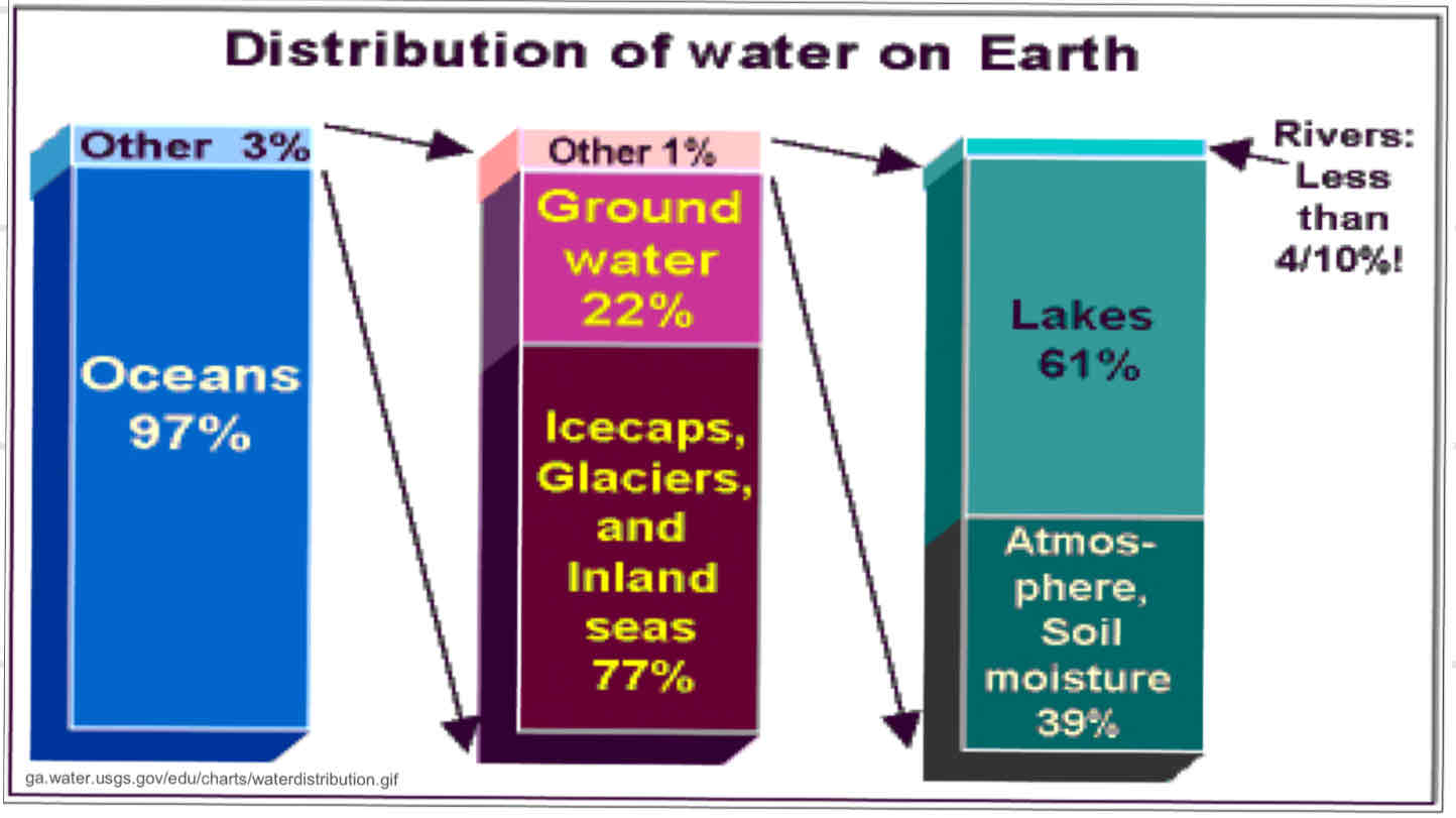
The distribution of water on earth
When ice melts/breaks off and enters sea, it changes the balance of fresh and saltwater → rising sea levels, water insecurity, less freshwater
Saltwater can not be used
The importance of rivers
Provide water and nutrients for agriculture
Provide habitat to divers flora and fauna
Provide commerce routes
Provide recreation
Provide electricity
Relationship between river discharge and stream flow
Increased flow = increased discharge
Water flow influenced by gravity (causes downstream flow) and friction (w/ bed and bank, opposes downstream flow)
Stream flow is turbulent, not steady, bc of complex channel shapes (meandering), high velocity, and cavitation
Relationship between discharge and stream characteristics
Velocity
Downstream = high pressure + velocity (bc many smaller rivers join)
Steeper = high velocity (bc gravity)
Friction = uneven distribution of velocity (slowest near bed, fastest near centre)
Channel shape
hydraulic radius
Shape determined by material
Silt/clay = steep, deep, narrow valleys
Sand/gravel = wide, shallow
Channel roughness
smooth = carry more water
Friction from irregularities in river bed, trees, vegetation = low velocity
Channel size
wide and deep = higher discharge
Stages of rivers
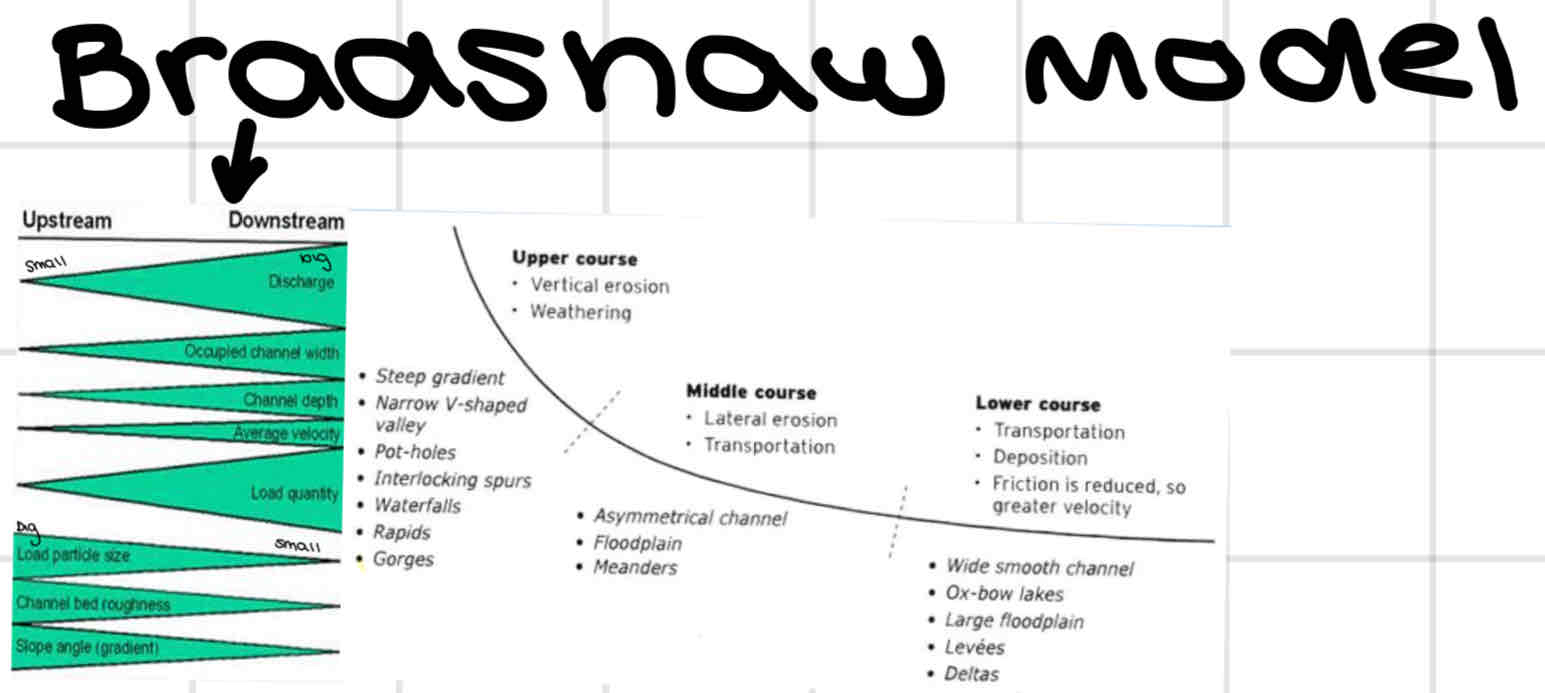
Upper, middle, lower course
Discharge, width, depth, velocity, load increase downstream
Channel roughness, load particle size, slope angle decrease downstream
Stages of river development
Youth stage
V-shaped valley
Fast moving water
Erosion and turbulence
Little deposition
Rapids, waterfalls, boulders
Mature stage
vertical erosion continues but lateral erosion evident (wider)
Meanders and flood plains
Water velocity slows
Deposition
Old stage
flood plain widens
Natural levees
Extensive meanders
Oxbow lakes
Developed river delta
River processes of erosion and the spatial and temporal factors influencing their operation (channel characteristics and seasonality)
Erosional action of rivers
Hydraulic action
water loosens and moves material
High velocity = high erosion
Abrasion
debris is abrasive → smooth beds and banks
High velocity = high abrasion
Attrition
rocks strike one another into smaller pieces
Corrosion
influenced by [solute] of water, discharge, velocity
Factors affecting erosion
load: heavier and sharper = more erosion
Velocity: higher = more erosion
Gradient: higher = more erosion
Geology: soft unconsolidated rocks (sand, gravel) easily eroded
PH: more acidic = more erosion
Human impact: deforestation, dams, bridges = more erosion
River processes of transport and the spatial and temporal factors influencing their operation (channel characteristics and seasonality)
Ways rivers transport sediment
solution (dissolved)
Suspension (dirty water, smallest particles)
Saltation (larger particles bounced downstream)
Traction (pebbles, roll downstream)
Floatation (leaves, carried on surface)
Relationship btwn river velocity and particle size )Hjustrom curve

River processes of deposition and the spatial and temporal factors influencing their operation (channel characteristics and seasonality)
Deposition caused by shallowing gradient → decreased velocity, energy, volume + increased friction btwn water and channel, human activity like dam
How does seasonality affect river processes
Precip affects velocity and amount of water
River processes are based on amount of water/velocity
E.g. more water in spring bc melt
the formation of meanders
Meanders occur when channel slope, discharge, and load make a situation where it is the only way a stream can spread its energy over channel length
Meander becomes more pronounced as streamline shifts btwn river banks
May form oxbow lake

The formation of flood plains and levees
When river floods speed decreases bc vegetation on flood plain
River deposits load - heavy first and closest, then lighter last and further

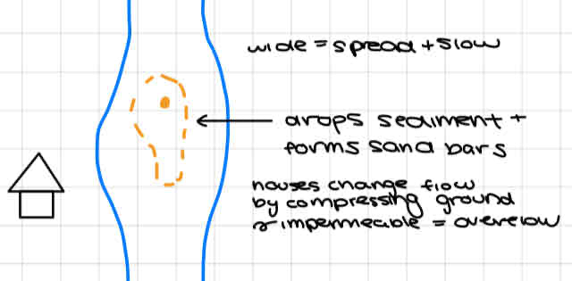
The formation of sand bars
The formation of deltas
When stream flows into standing body of water, may form delta
Meeting btwn ocean and river
Sea erodes deltas, river deposits load bc decrease in velocity
Types:
Arcuate (e.g. Nile River)
many distributaries that carry water and sediment
Inverted cone shape
Birds Foot (e.g. Mississippi River)
Many distributary channels branch out from main river channel
Estuarine (e.g. Vancouver delta)
least common
Forms when river sediment deposited in submerged river mouth
The formation of waterfalls
Formed when layers of sediment erode at diff rates (e.g. limestone vs. Sandstone)
Soft rock undercut by hydraulic action/abrasion
Weight of water and lack of support → waterfall collapses and retreats
May retreat to form gorges/ recessions

Formation of river terraces

Formation of braided stream/river channel

Hydrograph characteristics and natural influences on hydrographs
Peak discharge: time of max discharge (higher in large basin)
Lag time: period of time btwn peak rainfall and peak discharge (influenced by basin shape, steepness)
Falling limb: period when river discharge is falling
Normal flow: river’s base flow, slow movement + long-term supplier of Q
Rising limb: period of rising discharge following period of rainfall, indicates amount of Q and speed it is increasing (steep in flash flood, small drainage basins, urban areas)
Peak rainfall: the hour of greatest rainfall during storm
Hydrograph size: area under graph (high rainfall and basin size = high Q)
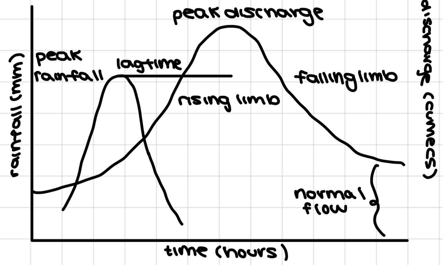
Factors affecting flood hydrographs
climate: rainfall total, rainfall intensity, évapotranspiration
Vegetation cover: intercepts rainfall so flood less likely
Soil: clay soils → overland flow → more flood, sharp hydrograph
Infiltration capacity: sand, soil, big rocks, clay, etc have diff ability to hold rainfall
Rock type: permeable rocks allow more water to infiltrate
Slope angle: steeper slope = greater runoff and less infiltration, flat = more infiltration, more through flow, lower hydrograph peaks)
Drainage density: more stream channels = more water into rivers
Basin size: shape and relief/slope - small, steep basins = less lag time
Human activity:
more impermeable surfaces and additional drainage channels increases flood risks
Dams disrupt flow
How do floods happen
Floods happen when river can no longer contain water it is transporting in its channel
Water flows out of channel to flood plain
Small floods contained on flood plain close to river
Large floods are less frequent but cover more flood plain
Factors affecting flood risk
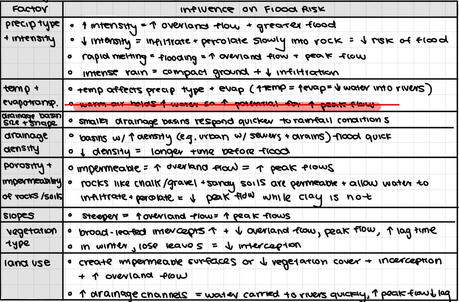
How urbanization, deforestation, and channel modifications affect flood risk within a drainage basin including its distribution, frequency, and magnitude
Urbanization (Urban vs. Rural hydrology)
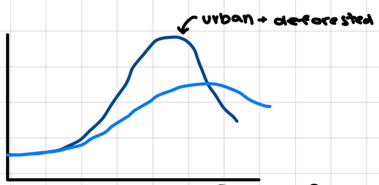
urban areas have shorter lag time, steeper rising limb, higher peak discharge, steeper recessional limb
Causes
- more impermeable surfaces (roads, buildings, pavements, roofs) → lower absorption rates and more overland flow
More drainage channels (gutters, drains, sewers) → increased drainage density
Natural rivers constricted by bridge supporters/riverside facilities → less carrying capacity
Deforestation (from land-use changes like agriculture, development)
vegetation increases interception, decreases overland flood, increases évapotranspiration - deforestation has the opposite effect
Hydrograph has shorter lag times, higher peak flows
Vegetation loss → higher flood risk
Tree removal → erosion and deposition in channel → artificial dam that decreases channel capacity and increases flood run-off
Channel modification
straightening
Water moves faster and is removed from an area quickly
Only mitigates - flooding at end
Channelization
Create new flood-relief channels
only mitigates - flooding downstream
Levees/dikes
Enlargers channels and increases river bank height → increased carrying capacity
Divert and restrict water to low-value land on flood plain
Widening and deepening
Increases carrying capacity
Dredging
Remove sediment from bed
Increases carrying capacity
Attempts at flood prediction
Flood forecasting and warning has become more accurate (satellite, radar)
Making warnings available to ppl is easier bc television, phones, computers
Forecasting can be used to reduce problems caused by flooding
BUT there are problems
not much flood warning time
LICs have much less effective forecasting
Poor have least access to new tech and info
GCC = uncertainty in climate modelling bc erratic rainfall, frequent floods
Flood mitigation through structural measures
Dams
control river flow by holding back water during flood and releasing when risk is gone
Afforestation
increased interception, less erosion, less overland flow → reduced risk
Initially may increase bare ground from overland run-off, decreased ground vegetation, young trees, tractor routes
Channel modification
raising banks, straightening, channelization, artificial levees, dredging
Flood mitigation through planning
Personal insurance + Loss sharing
Disaster aid (money, equipment, staf)
Insurance in HICs (but not all have it and often underinsured)
Flood preparation
Use sandbags to protect home
Seal doors and windows
Move valuables upstairs
Move electrical generators to building tops
Design homes so electrical features higher than expected flood levels
CASE STUDY: Flood mitigation in Thames River, England
Thames is longest river in England, drains entire Greater London area
2014 major floods Bc increased precip and storms
groundwater build up
Rivers reaching full capacity
Artificial channel diverted water further downstream but severe flooding downstream
Power less, deaths, evacuation
Flood mitigation
planned new additional channels (didn’t happen)
Improved existing channels
Installed property-level products
Better flood response plans
CASE STUDY: Dam in Nile River, Egypt
Nile river important for agriculture
Aswan High Dam build → irrigation, power source, farming land
Undesirable side effects
flooding of temples and statues (tried to bury w/ sand, build wall, move temples)
Decreased flood → less fertile land + reliance on imported fertilizer
Increase SA → water lost to evap
Erosion
The 3 components of water scarcity
Water shortage: when water quality declines over time bc dynamic factors like climate change, pollution, increasing demand for water
Water stress: when water demand exceeds amount available/when poor quality of water restricts its usefulness
Water crisis: when supplies of clean, usable water cannot support sufficient food production/other legitimate domestic industrial, environmental needs
Factors causing deterioration of water quantity
Water is a finite resource
Volume of water available does not change but increasing ppl want to use it
Therefore quantity of water/person is decreasing
Factors causing deterioration of water quality
Pollution - sewage, factories, agricultural runoff, garbage
Turbidity - cloudiness from stream erosion
Siltation + sedimentation - erosion of hill slopes
Salinity - over irrigation of agricultural fields
Bacterial disease - animal manure
These can be affected by over-use, excessive extraction of groundwater, political conflict, lack of infrastructure investment
Physical vs economic water scarcity

Causes and impacts of drought
Causes: seasonal/weather events
Impacts:
decreased crop yield (heat)
Mortality (elderly)
Illness (water quality)
Forest fire (uses water)
Stakeholders in the environmental consequences of agriculture on water
Farmers (apply fert for increased yield)
Chemical companies (make fert)
Oil and gas companies
Government (try to achieve food security)
Customers (rely on food supply and availability)
Water companies (provide water to consumers)
Citizens (responsible for clean up)
Environmental consequences of agriculture on water (irrigation)
benefits: increase productivity → increase food availability, decrease food prices, increase employment, faster agricultural/economic development → world wide crop production heavily dependent
Consequences:
Less downstream flow bc removed from river
Water lost to groundwater store/atmosphere when added to fields
Salinization
Excess surface water from over irrigation → water passes over soil and dissolves salt + waterlogging (water table rises) frees up salt to rise → encourages evap which leaves salt in soil
Soil is not good for cultivation, destroys plumbing appliances, salt water not drinkable
Excess irrigation water tuns off into streams and carries salt downstream
Environmental consequences of agriculture on water (eutrophication)
Causes:
farms use ferts to increase productivity
Consequences:
fertilizer runs off and increases nitrogen in water
Algae grows quicker w/ nitrogen → blooms
Blooms cover reservoir so no light let in
Algae consumes oxygen → anaerobic conditions → organism death
Kills water source (still lakes)
Decreased water quality → scarcity
Solutions
decrease nitrate ferts
Educate farmers
Remove anaerobic mud from lake
Environmental consequences of agriculture on water (clear cutting)
Soil creeping down → landslide → turbidity and siltation
Can’t drink water bc organic materials
Environmental consequences of agriculture on water (pesticides + herbicides)
Consequences:
Don’t meet target species
Build up in soil/water
Solutions
Regulations for biodegradable pesticides
Biological pest controls
CASE STUDY: poor water management in the Aral Sea, Kazakhstan + Uzbekistan
Sea shrinking and drying up
Causes:
cotton farming
Was major cotton growing region of USSR
Irrigation needed to grow cotton in desert
Dams and canals diverted water to cotton farms → less water reaching sea
Deteriorating water quality
Sea → saltier bc evaporation
Industry pollution from fert, insecticide, herbicides applied to cotton returning to river w/ irrigation water and into sea
Impacts
affect wildlife (fishing industry)
Wells dried up bc water table dropped
Unemployment and migrate away
health problems (chemical seepage into water supply)
Future implications
international cooperation needed
Pops need safe drinking water
Consider sustainability of cotton growing
Redesign irrigation system
CASE STUDY: Water scarcity in Colorado River, Mexico + USA
Physical water scarcity bc dry climate
Growing urban pop → increasing water demand
Farmers want to grow crops w/ irrigation (bc warm climate and increasing demand)
high demand in area of scarcity → international tensions btwn Mexico + USA
Increased water use → river dries up before reaching sea
Irrigation runoff (overirrigation) → salinity and poor water quality
Mexico gov complained
US agreed to address water quantity problem, but Mexico pushed new agreements about water quality (salinity)
Colorado RIver Compact signed but did not consider Mexico’s needs
Growing human pressures on lakes and aquifers affecting groundwater management
Distribution of water changing bc GCC
Pop + economic growth → increasing demand
Aridity + heat → physical water scarcity
Groundwater is used by humans through extraction and storage - draw an aquifer
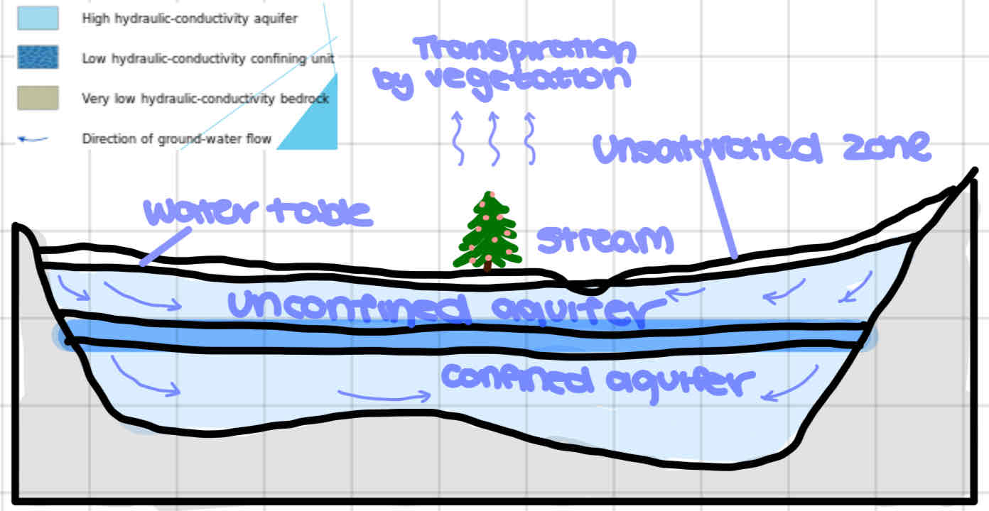
Groundwater is used by humans through extraction and storage - draw an artesian aquifer/basin
Artesian aquifer: confined aquifer containing groundwater under positive pressure, causing water level in a well to rise to a point where hydrostatic equilibrium reached
Artesian basin: large artesian aquifer (e.g. Great Artesian Basin, Australia)

How do aquifers/artesian aquifers recharge
Natural: hydrologic cycle
Artificial: water pumped into aquifer down bore holes or recharge basins (large reservoirs w/ porous bottoms so water seeps into aquifer)
Importance of lakes and ponds and the increasing pressure placed on them
Importance
Biodiversity (habitats and breeding)
Water cycle (protect from flood, recharge groundwater)
Human use (agriculture, industry, domestic, recreation)
Pressure
pop growth and economic development → pressure on water quality
Chemical pollutants, sewage, aggro-chemical flows of pesticides and ferts
Irrigation → lakes drying up
Climate change → changes in distribution + timing
Impacts of groundwater abstraction

Causes of conflict from internationally shared water resources
There are many trans-boundary river basins + aquifers → potential for conflict
Water quality problems can escalate to disagreements over shared resource
Water scarcity - water access needed to survive and another country restricts
Large-scale water developments → conflict w/ neighbouring countries + internal conflict bc displacement of communities
Climate change → increased temps and evap loss and droughts and floods → scarcity and need to build water developments → tensions
What factors make conflict over internationally shared water resources more likely
Degree of water scarcity
Extent to which a water supply is shared
Relative power of countries sharing it
Access to alternative supplies
CASE STUDY: conflict over internationally shared water resource Nile River
Egypt highly dependent on Nile
Upstream countries need it too - Sudan needs to increase food production but faces water scarcity
Egypt and Ethiopia unwilling to negotiate w/ Sudan
Methods to decrease potential conflict over water resources
Follow international law (e.g. UN treaties)
Equitable utilization - each country entitled to reasonab;e share
Avoid causing harm to other countries
Notify and inform of actions on shared rivers
Share data
Work together to manage resources
Resolve disputes peacefully rather than war (requirement of UN charter)
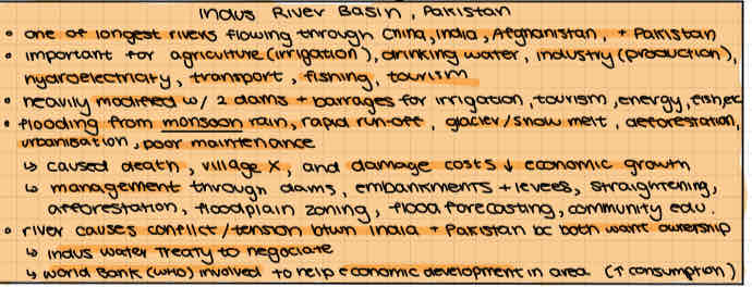
CASE STUDY: conflict over internationally shared water resource Indus River Basin
Flows through China, India, Afghanistan, Pakistan
Important for agriculture, drinking, industry, hydroelectricity, transport, fishing, tourism
River causes conflict btwn India and Pakistan bc both want ownership
Indus Water Treaty to negotiate
World Bank involved to help economic
The problem of water supply is from many interacting factors such as…
Uneven distribution
rainfall + runoff high in some places low in others
Retention and distribution of water consumes many resources
cities need to build dams and pipelines
Semi-arid rural communities need indifidual effort and time to dig wells and transport water
Most of the world’s water is inaccessible/difficult to access
Do water management issues differ in LICs and HICs
Water management issues differ bc of degree of water scarcity/excess, culture, economic health

much of the responsibility to manage water falls on local communities - community actions to manage water in LICs vs HICs

Most efforts to manage water focus on first-time water use. Explain the significance of reusing and recycling water
Industry and modern lifestyle waste lots of water that can be recycled
But costs of water too low to be incentive for recycling, and cost of tech to purify water is too expensive
Water scarcity is increasing so ppl must become better at preventing water pollution and be ready to pay for water treatment
Why are dams built
Flood and drought control
Irrigation (agriculture and oil)
Hydroelectricity power
Improved navigation (control river depth)
Recreation and tourism (boating and fishing)
Domestic and industrial water supply
Benefits of dams
Economic development from increased agriculture and other activities
Hydroelectricity is clean energy
Water supplies secure and reliable
Local employment
Less flood risk
Large bodies of water moderate cliamate
Improved ecological balance
Consequences of dams
Physical effects
evaporation losses
Increased groundwater seepage
Decreased volume of water downstream
Increased severity of earthquakes
Growth of weeds + eutrophication
Decreased flow → death of riverbank and floodplain vegetation
Deposition within lakes
Erosion of delta (bc less sediment and higher velocity)
Decreased fish stocks
Lack of sediment movement downstream
Less flood so can’t use as natural fertilizer
Less nutrients downstream → deterioration of aquatic life
Socioeconomic problems
flooding of historical sites
Displacement of population
Less fertile farmland that relied on floods
Waterborne disease
CASE STUDY: The Three Gorges Dam, Yangtze River Basin, China
Annual floods in basin from snow melt → loss of lives and grain crops
Built dam to
Control annual flooding
Generate hydroelectricity
Increasing shipping capacity
Benefits:
safer shipping
Increased employment → migration
Provinces near dam → wealthier
Hydro → less GHG and air pollution
Reservoir moderates temp
Consequences
Many people relocated
Cultural monuments lost
Provinces away from dam lost funding bc cost of dam
Vulnerable to military attack bc country dependent on single energy source
Dam traps sediment and reservoir fills w/ it
Increased likeliness of earthquake
Rebuild downs
Water carries less sediment → erosion
Wildlife habitats drown
Increased evap
What are Integrated Drainage Basin Management (IDBN) schemes
Aim to deliver sustainable use of world’s limited freshwater resources
Manage drainage basin as a single integrate unit, as there are many inte-related and inter-dependent factors involved
Elements to successful IDBN
Govs, industries, ppl have long-term vision agreed to by all stakeholders
Integration of policies, decisions, costs across interests
Strategic decision-making
Participation by all stake-holders
Well-informed, transparent planning
Adequate investment
Knowledge of river basins and the natural and socioeconomic forces that influence it
Global Water Partnership (GWP)
International advisory body for IDBN
5 principles
Multiple uses (drinking, washing, livelihood)
Holistic management (examine supply and demand)
Multiple perspectives (economic, social, environmental need)
Participatory approach (local communities involved)
Women’s involvement (role in collecting, distributing, and managing, esp in LICs)
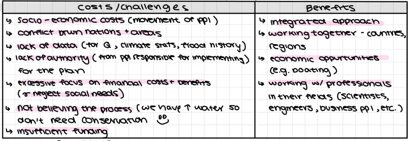
Costs and benefits of IDBN
Keep in mind costs/benefits difficult to compare bc benefits cannot be quantified like costs
CASE STUDY: IDBM plan for the Broadlands Rivers Catchment
Background
Broadlands River catchment supplies water to eastern Englands Broads
Water demand from
Tourism (boating, fishing) brings in money and supports many jobs
Farming (fertile land) supports many jobs and occupies most of the land
Processes
Desire to expand agriculture for increasing + remove mosquito breeding ground → broads drained → less peat production (fuel) + sinking
Broads used as sewage disposal → eutrophication
New farmland created → vegetation destroyed → eutrophication
Boating → riverbank erosion + stir up sediment → sediment downstream
Cattle trampling → bank collapse + siltation
2014 IDBM Plan aiming to address problems of
Water quality (waste + pesticides)
Habitat protection
River flooding
Land management for farmers
Involving local communities
Why are wetlands drained
Wetlands referred to as useless space (smell, breeding ground for pest and disease)
Made useful by drainage
makes agricultural space
Oil and gas exploration
Peat is fuel
Importance of wetlands
Filtration (peat purifies impurities)
Biologically diverse ecosystem (habitats and breeding)
Carbon source (peat)
Store floodwater
Control erosion (slows water + grows vegetation that holds sediment)
Economic value as tourist attractions
Support livelihoods (fishing, hunting)
Ramsar Convention
International treaty to halt worldwide wetland loss and conserve through wise use and management
Signed in 1971 after concerns about world-wide wetland threats
Countries meet every 3yrs to make politics and monitor wetlands
Operates under 3 pillars
Work for wise use of all wetlands
Designate wetlands for List of Wetlands of International Importance
Cooperate internationally on transboundary wetlands
CASE STUDY: future possibilities of the Florida Everglades
Background
internationally significant wetland on Ramsar List
Fragile ecosystem disturbed by competing demands by humans
Water demand
Warm climate and fertile soil → cleared for farming
Annual flooding → drainage canals built to carry water to ocean + Herbert Hoover Dyke dam built
Population growth → water use
Holiday visitors → water use
Impacts of human water use
Groundwater wells → saltwater intrusion
Roads and buildings → water can’t replenish groundwater + drillers must dig further → more room for saltwater
Canals → less flow → ground dry out → fires + soil oxidizes → decreased soil levels → expose roots, pipes, power cables
Farmers upstream release fertilizers + pesticides → mercury
Management
established as national park
Positives: visitors can see w/o damaging as much, more ppl who understand environment
Negatives: more visitors cause damages
Conservation measures (releasing water, removing invasive plants)
Community responsibility to protect
Tourism to brin in finances and educate visitors
CASE STUDY: Flood mitigation Indus River
