Coastal Environments Test 1- Cooper
1/27
There's no tags or description
Looks like no tags are added yet.
Name | Mastery | Learn | Test | Matching | Spaced |
|---|
No study sessions yet.
28 Terms
Types of plate tectonic boundaries and how they relate to coastal
classification (Active and Passive Margins)
Divergent Plate Boundary: moving apart
- Convergent Plate Boundary: moving together
- Transform Plate Boundary: sliding past each other
- Passive Margins: Little tectonic activity (No plate boundary)
- Active Margins: Lots of tectonic activity (Plate boundary
Features of continental margins (Shelf, Break, Slope, Rise)
Active: Cliff shorelines, narrow continental shelf, narrow coastal plain, deep trenches, mountains just inland
Passive: Beach shorelines, wide continental shelf, wide coastal plain, large rivers
Common coastal classification schemes (Erosional and Depositional)
Erosional Coasts: Coastal processes remove rock and sediment, dominated by sea cliffs, common on active margins; form in areas with steep coast and minimal sediment supply
- Depositional Coasts: Coastal processes redistribute rock and sediment, dominated by beaches, common on passive margins
Coastal materials (common rock/sediment type) and their source
Granite
- Sedimentary Clastic
- Sedimentary Carbonate
- Metamorphic
- Igneous
- Sediments
- River, wind, weathering of rock, activity of living organisms, volcanic eruptions, chemical reactions
Sediment properties (grain size, sorting etc.)
- Grain Size
o Pebbles (4-64 mm)
o Granules (2-4 mm)
o Coarse Sand (.5-2 mm)
o Medium Sand (.25-.5 mm)
o Fine Sand (.06-.25 mm)
o Silt (.004-.06 mm)
o Clay (<.004 mm)
- Sorting
o Well Sorted (.35 phi)
o Moderately Well Sorted (.50 phi)
o Poorly Sorted (1.00 phi)
o Very Poorly Sorted (2.00 phi)
- Sediment Particle Shape
o Low Sphericity -> High Sphericity
o Very Angular, Angular, Sub-angular, Sub-rounded, Well Rounded
- Source
o Terrigenous: Erosion of land, volcanic eruption (45%)
o Biogenous: Accumulation of the hard parts of marine organisms (55%)
o Hydrogenous: Precipitation of dissolved minerals from water
o Cosmogenous: Meteorite Debris
Common instruments/tools used to measure sea level
Tide Gauge
- Tide Gauge Analog
- Tide Gauge Modern
- Satellite Altimetry
Purpose and geometry of the ellipsoid and geoid
- Ellipsoid: An idealized geometric model of the surface of the Earth; deformed sphere in which one or more axis of symmetry are not equal.
- Geoid: Equipotential surface selected to best fit sea level; not a smooth surface-reflects variability in mass and density of lithosphere
Processes that cause eustatic sea level to change
Thermal Expansion, Orbital Patterns, Aerosols/Atmospheric Composition, and Human Induced
Processes that cause tectonic sea level change (i.e. crustal
subsidence/uplift)
Subduction, Isostatic Adjustment, Sediment Loading
Forces that generate tides
Gravity from the sun and moon, motion of earth, inertia of water
Equilibrium and dynamic theory of tides
Equilibrium Theory of Tides: Explains tides by examining the balance and effects of forces that allow our planet to stay in orbit around the sun, or the moon to orbit the Earth
Dynamic Theory of Tides: Considers seabed contour, water’s viscosity, and tide wave inertia
Three types of tidal pattern
- Diurnal: Occur once in a lunar day; 24:50 – high tide to next high tide
- Semidiurnal: Occur twice in a lunar day; 12:25 – high tide to next high tide
- Mixed Tide: Combines both diurnal and semidiurnal tides; 12:25 – high tide to next high tide
Cause of spring/neap tides
- Spring: occur when gravitational effects of the sun and moon combine, producing high high tides and low low tides
- Neap: Occur when the gravitational forces of the sun and moon are perpendicular, and the bulges created by their gravitational pull cancel each other out
Amphidromic circulation
Amphidromic point: Center of basin, has No tide. Tidal Ranges increase with distance from Amphidromic points. Large scale circular rotations of tides
Causes of water level deviation from predicted tides
Storm Surge
Strong on-shore or offshore winds
Tsunami
Variables used to describe wave properties
Wave Height (H): Vertical distance from crest to trough
Wavelength(L or λ): Horizontal distance between successive crests (or troughs)
Amplitude(A): One half wave height (H/2)
Period (T): time for one wavelength to pass a point in space
Celerity (C) (wave speed) = Wavelength / Period (L/T)
Frequency(𝑓)= 1 / Period (number of waves per second)
Processes that generate waves and control wave growth
Wind: Wind Strength, Wind duration, Fetch
Wave dispersion
Waves with different wavelengths travel at different speeds
Common instruments/tools used to measure waves
Buoy, Wave staff, Satellite
. Difference between shallow water and deep-water wave conditions
Deep-water wave speed: depth greater than ½ wavelength
Shallow-water wave speed: depth less than 1/20 wavelength
As water depth decreases:
Wave speed slows
Wavelength decreases
Height increases
Period remains constant
Waves become Slower and Steeper
Forces controlling wave speed and wavelength
The speed of an ocean wave is proportional to its wavelength and if affected by water depths
How waves physically transform as they shoal (including orbitals)
As shoaling waves approach the shore and enter water depth that are ½ their height increases and wavelength decreases resulting in steeper waves.
Breaking wave types and what controls them
Spilling Breaker: has a flat bottom,
Plunging Breaker: has a steep bottom
Surging Breaker: has a very steep bottom
Wave refraction
The bending of wave crest as waves approach the shoreline due to interaction (friction) with the seafloor
Results in waves becoming more parallel with the shoreline
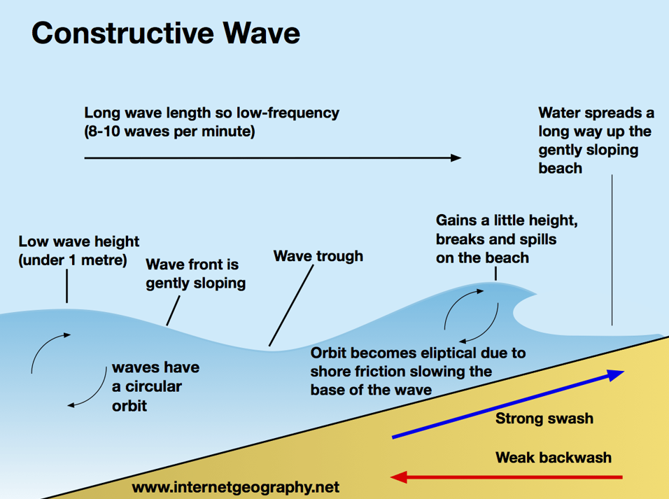
Constructive Waves
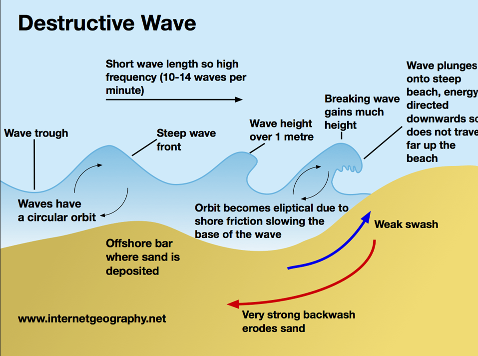
Destructive Waves
Tsunami generation. Tsunami wave properties
Very long wavelengths waves caused by rapid displacement of water; Not caused by wind (Earthquakes, Volcanic Eruptions, Landslides, Asteroid Impacts); Always shallow water waves; Very rapid-function of water depth
Beach Slope – Grain Size
Larger grain size = steeper slope