Unit 6 Ap Human Geography
4.0(2)
Card Sorting
1/60
There's no tags or description
Looks like no tags are added yet.
Last updated 7:10 PM on 4/30/23
Name | Mastery | Learn | Test | Matching | Spaced | Call with Kai |
|---|
No analytics yet
Send a link to your students to track their progress
61 Terms
1
New cards
influences on urbanization
changes in
-transportation
-communication
-population growth
-migration
-economic development
-government policies
-transportation
-communication
-population growth
-migration
-economic development
-government policies
2
New cards
situation
the location of a place relative to other places (what is it near)
ex:located near shipping routes (Hong Kong, Singapore)
ex:located near shipping routes (Hong Kong, Singapore)
3
New cards
qualitative data
from field studies and narratives provide information about individual attitudes toward urban change.
-maps show ethnicity of neighborhoods and other characteristics like predominant gender
-maps show ethnicity of neighborhoods and other characteristics like predominant gender
4
New cards
quantitative data
about a city's population is provided by census and survey data and provides information about changes in population composition and size in urban areas
-with this data from the census, lawmakers can create maps to look at residential and racial segregation
-with this data from the census, lawmakers can create maps to look at residential and racial segregation
5
New cards
site
the actual physical qualities of a place
ex: valley, mountains
ex: valley, mountains
6
New cards
megacity
City with more than 10 million people found increasingly in periphery and semi periphery
ex: Paris, Sao Paulo
ex: Paris, Sao Paulo
7
New cards
meta-city
a large city with over 20 million people and found increasingly in the periphery and semi-periphery
ex: Beijing, tokyo
ex: Beijing, tokyo
8
New cards
Ecumene
A variety of of community types with a range of population densities.
9
New cards
suburbanization
the transformation of large areas of rural land to urban uses
10
New cards
edge city
a concentration of residential and economic (business, shopping, entertainment) activity located in the suburbs
11
New cards
Metropolitan statistical area (MSA)
a central city of at least 50,000 people and urban areas linked to it.
12
New cards
exurb
a residential area beyond the suburbs, often in more rural areas
13
New cards
boomburbs
large, rapidly growing, incorporated communities of more than 100,000 residents that are not the biggest city in their region.
14
New cards
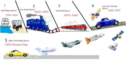
Borchert's transportation model
a model that describes urban growth based on transportation technology
15
New cards
world city
a city that is a control center of the global economy, in which major decisions are made about the world's commercial networks and financial markets. (Tokyo, Paris, New York City)
16
New cards
network
a system of interconnected people or things e.g. transportation, communication, financial, governmental
17
New cards
urban hierarchy
ranking urban settlements by: population size and economic function
18
New cards
rank size rule
the idea that the population of a city or town will be inversely proportional to its rank in the hierarchy
if the largest city in a country contained 1 million citizens then:
2nd largest city would contain 500,000 (1 million/2)
3rd largest city would contain 333,333 (1 million/3)
4th largest city would contain 250,000 (1 million/4)
if the largest city in a country contained 1 million citizens then:
2nd largest city would contain 500,000 (1 million/2)
3rd largest city would contain 333,333 (1 million/3)
4th largest city would contain 250,000 (1 million/4)
19
New cards
primate city
an urban area that dominates its country's economy, culture, and political affairs and is more than twice the population of the next largest city.
ex: London, Paris, Bangkok
ex: London, Paris, Bangkok
20
New cards
gravity model
interaction of places based on their population, sizes, and distances between them
21
New cards
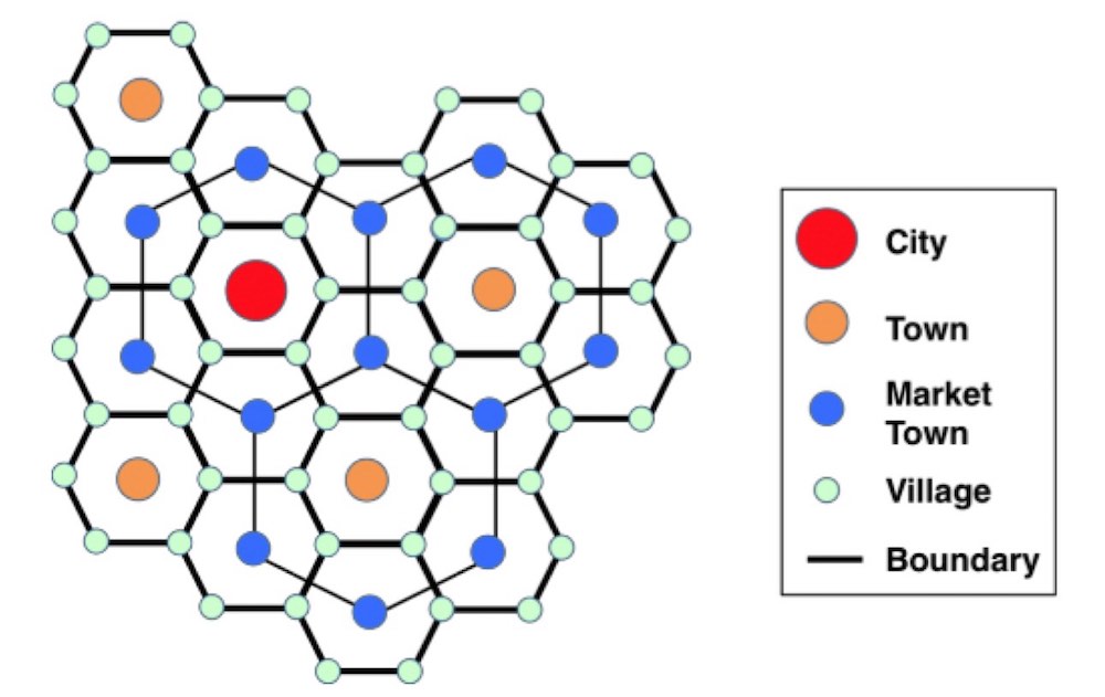
Christaller's Central Place Theory
explains how services are distributed and why a regular pattern of settlements exists.
22
New cards
low order central place functions
are used by consumers on a regular/daily basis and as a result, people are not willing to travel for to use them
ex: Walgreens, gas station, grocery store
ex: Walgreens, gas station, grocery store
23
New cards
high order central place functions
are used less frequently by consumers and as a result, people are willing to travel further for it
ex: baseball games, football games, hospitals
ex: baseball games, football games, hospitals
24
New cards
threshold
The \# of people required o support businesses
25
New cards
range
the distance people will travel to acquire a good
26
New cards
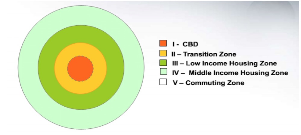
Burgess Concentric Zone Model (E.W. Burgess 1923)
divides the city into 5 concentric zones defined by their function, centered around the CBD.
27
New cards
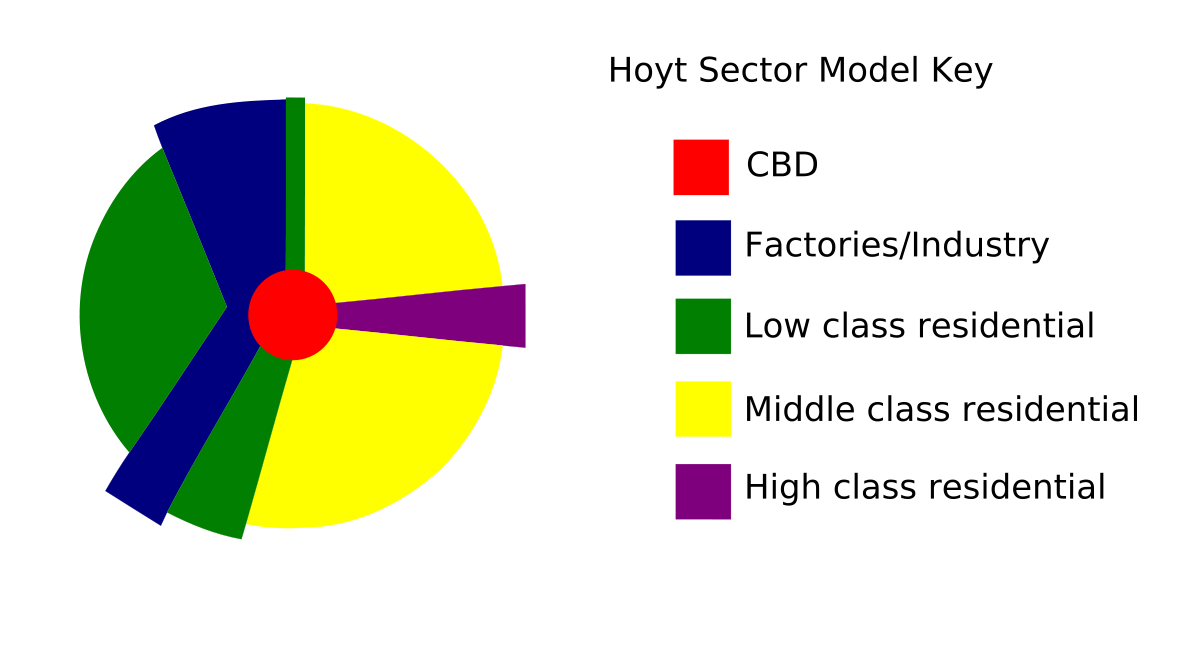
Hoyt Sector Model (Home Hoyt 1939)
zones expanded outward from the city center along transportation corridors creating a wedge shape. As growth occurs, similar activities stay in the same area and extend outward.
28
New cards
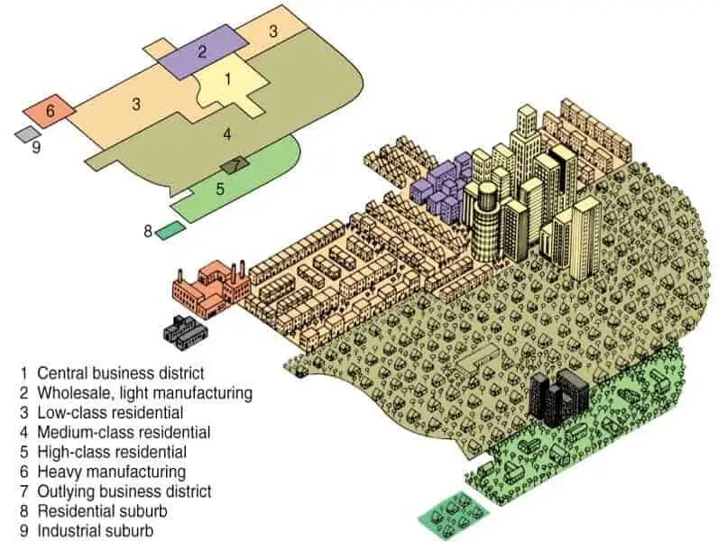
Harris and Ullman Multiple Nuclei Model-
Chauncey Harris and E.L. Ullman (1945)
Chauncey Harris and E.L. Ullman (1945)
for developed countries and large expanding cities. The CBD is scattered into several nodes, with transportation hubs near industries and airports. Low income housing is found near workers while high income housing is found in elite districts
29
New cards
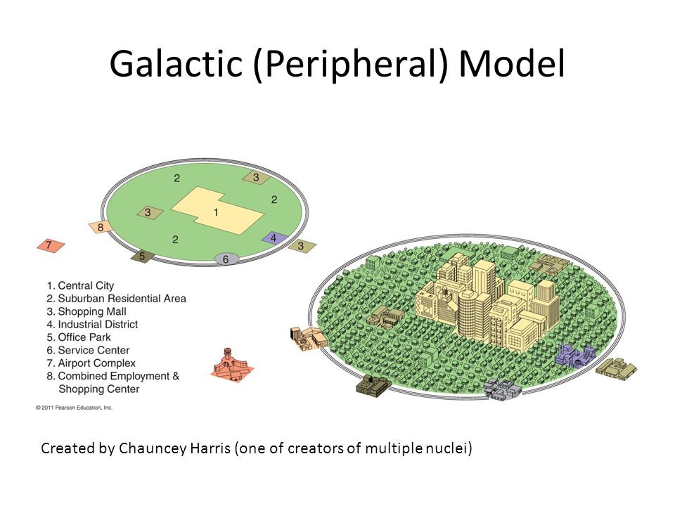
Galactic City Model (Peripheral Model)
updated `model` by Chauncey Harris (1997)
updated `model` by Chauncey Harris (1997)
consists of an inner city, surrounded by large suburban residential and business areas and tied together by transportation nodes (edge cities)
30
New cards
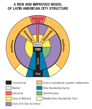
Latin American City Model (Griffin Ford 1980)
attempting to generalize Latin American cities. Mall, spine, disamenity zone, etc.
31
New cards
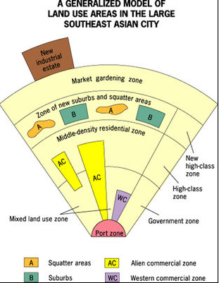
### Southeast Asian City Model (McGee 1967)
several cities in southeast asia share certain aspects of land use: old colonial port zone surrounded by a commerical business district, western commercial zone, alien commercial zone, no formal CBD, hybrid sectors and zones growing rapidly new industrial parks on the outskirts of the city.
32
New cards
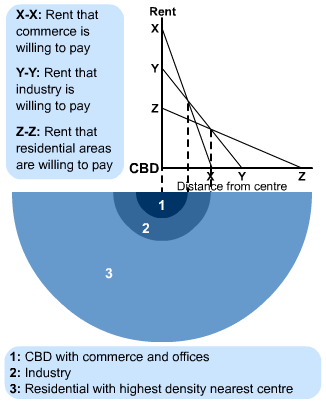
Bid rent theory
geographical economic theory that refers to how the price and demand on real estate changes as the distance towards the Central Business District (CBD) increases.
33
New cards
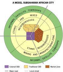
Sub-Saharan African City Model (de Blij)
fast growing cities with three CBDs: colonial CBD, traditional CBD, and market CBD. The quality of residence gets poorer the farther from the CBDs. Lacks elite, middle class, or gentrification zones which shows a lack of development.
34
New cards
housing discrimination
The illegal practice of denying an individual or group the right to buy or rent a home based on race, color, religion, national origin, sex, disability or family status.
35
New cards
redlining
discriminatory real estate practice in North America in which members of minority groups are prevented from obtaining money to purchase homes or property in predominately white neighborhoods
36
New cards
blockbusting
a real estate technique used to encourage people to sell their property at a very low price by giving the impression that the neighborhood was changing for the worse, especially in reference to minorities moving in and led to a significant turnover in housing which benefited real estate agents and led to the "white flight" to the suburbs
37
New cards
affordable housing
housing that people on low/limited income are able to afford to buy or rent
38
New cards
environmental injustice
disproportionate exposure to communities of color and the poor to pollution and its effects on health and the environment; includes inadequate access to healthy food, transportation, unsafe neighborhoods with poor water and air quality.
39
New cards
disamenity zone
area located within the city characterized by slums and the homeless and in extreme cases are controlled by gangs or drug lords
40
New cards
slow growth cities
slowing a citys growth to limit the problems associated with grwoth and improve sustainability.
41
New cards
land tenure
system regulating the rights to ownership and control and usage of land
42
New cards
inclusionary zoning
planning ordinances that provide affordable housing to people with low to moderate incomes
43
New cards
urban renewal
the clearing and rebuilding and redevelopment of urban slums
44
New cards
gentrification
the restoration of deteriorated urban areas by wealthier (mostly middle-income) people who move into, renovate, and restore housing and sometimes businesses
45
New cards
functional fragmentation of government
refers to the way governmental institutions are dispersed between many local agencies including state, county, city and neighborhood levels
46
New cards
urban sustainability
the idea that a city can meet the needs of the present without compromising the ability of future generations to meet theirs in terms of economic, environmental and social impact
47
New cards
medium density housing
townhomes, single unit housing
48
New cards
low density housing
residential homes, lots of open space fewest people per geographic unit (suburbs)
49
New cards
high density housing
high rises, most people per unit (cities). Land is more expensive in these areas and causes people to b more crammed into smaller apartments.
50
New cards
sustainable development
meeting human development goals while sustaining the natural systems that provide the natural resources upon which the economy and society depend
51
New cards
zoning
the practice of classifying areas for different types of development and land use
52
New cards
mixed land use
land development that blends a combination of residential, commercial, cultural, institutional and/or industrial uses
53
New cards
smart growth policies
urban planning that avoids urban sprawl and focuses on long term implications with sustainable design initiatives and guides development into more convenient patterns and into areas where infrastructure allows growth to be sustained over the long term
54
New cards
new urbanism
walkable blocks and streets, housing and shopping in close proximity, and accessible public spaces
55
New cards
socioculture patterns
-low income live closer to work/CBD
- middle and upper class move away from CBD as they can afford transportation
-suburbs (white)
-CBD (diverse)
- middle and upper class move away from CBD as they can afford transportation
-suburbs (white)
-CBD (diverse)
56
New cards
brown fields
abandoned industrial sites that are contaminated to the point that new development is curtailed
57
New cards
ecological footprint
how many resources consume and how much waste we produce faster than the world can handle
58
New cards
infilling
The process by which population density in an urban center is increased by building on waste land or underused land.
59
New cards
Megalopolis
a region in which several large cities and surrounding areas grow together
60
New cards
micropolitan areas
population between 10,000-50,000 people. Smaller city, and surrounding towns/counties
61
New cards
infrastructure
the basic physical and organizational structures and facilities (e.g., buildings, roads, and power supplies) needed for the operation of a society or enterprise.