ap hug unit 1
 Call Kai
 Learn
Learn Practice Test
 Spaced Repetition
 Match
Match Flashcards
 Knowt Play
1/39

There's no tags or description
Looks like no tags are added yet.
Name | Mastery | Learn | Test | Matching | Spaced | Call with Kai | Chat |
|---|
No analytics yet
Send a link to your students to track their progress
40 Terms
what is a thematic map?
communicates information about a place including spatial aspects (like what it is like there). it always displays data
choropleth
dot-density
graduated/proportional symbol
cartogram
isoline and topographic
what is a reference map?
how general information, like navigation and location. they show where things are.
political: states/countries/capitals
physical: natural features
road: highways, streets, etc.

what kind of map is this? what are its strengths and weaknesses?
choropleth map: uses various shades of a color or patterns to show location/distribution of spatial data
strengths: easy to collect data for (through census records, etc.); offer big-picture view of what’s being mapped
weaknesses: scale matters (doesn’t show regions of a country/makes them seem uniform), not 100% accurate
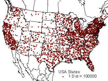
what kind of map is this? what are its strengths and weaknesses?
dot distribution/dot-density map: each dot represents a specified quantity of a spatial characteristic
strengths: extremely specific/accurate
weaknesses: takes longer to collect data; more expensive

what kind of map is this?
graduated/proportional symbol map: uses symbols of different sizes to indicate different amounts of a variable

what kind of map is this? what is it used for?
isoline map: use lines that connect points of equal value to depict variations in the data across space
used for weather and elevation

what kind of map is this?
topographic map: shows elevation through texture or through lines and their distance apart
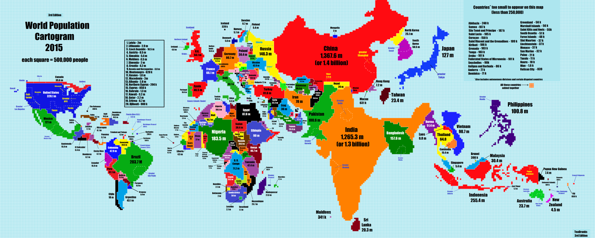
what kind of map is this? what are its strengths and weaknesses?
cartogram: the sizes of countries are shown according to a specific variable
strengths: displays just data; shows variables in proportion; good for visualization
weaknesses: distorts area and gives up geographical accuracy
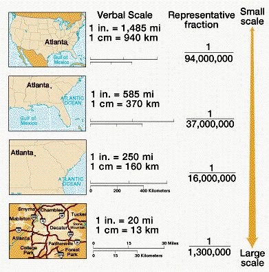
small scale maps vs. large scale maps?
small scale map: shows a large area with small amounts of data/detail
has a smaller ratio
zoomed out
large scale map: shows a small area with a large amount of data/detail
has a larger ratio
zoomed in
absolute vs. relative location?
absolute location: the exact, precise location of something, often denoted by address or latitude and longitude
relative location: the location of something based on its relationship to another place (reference point)
the way something is spread out over an area
distribution
an indication that two (or more) phenomena may be related associated, or correlated with one another
pattern
things on a map are close together
clustered/agglomerated
things on a map are far apart
dispersed
how many units are in a given area
density
what is remote sensing? what is it used for?
the use of cameras or other sensors mounted on aircraft or satellites which orbit the earth above the atmosphere to collect digital images of the earth’s surface
used for monitoring environmental changes and weather
what are satellite navigation systems, or global positioning systems (gps)?
satellites orbit the earth to communicate locational information to gps receivers
display absolute location and is used for navigation
what is geographic information systems (gis)?
computer system/software that stores, analyzes, and displays information from multiple digital maps or data sets
has both thematic and physical layers
what is space?
the measurable, physical distance between locations
location vs. place?
location: where something is on a map (describes where a place is located)
place: what is at a location (describes what a location is like)
site vs. situation?
site: local conditions
physical characteristics like climate, soil, landforms, minerals
human characteristics like age, education, savings, buildings
situation: a location’s relationship/link with the outside world
includes natural transportation corridors as well as roads, railroads, cables, airports
what is sense of place?
factors that contribute to the uniqueness of a location and can be used to distinctly identify a location (like if u saw a picture you’d know where it is)
a location’s name, usually reflecting the culture and history of a place
toponym
the increasing sense of accessibility and connectivity which seems to bring humans in distant places closer together (through globalization and technology)
time-space compression
what is friction of distance?
the fact that distance creates a barrier, cost, or resistance to the interaction between two places
what is distance decay?
the interaction (people, trade, etc.) between two places declining as the distance between two places increases
can also be caused not by distance but by physical barriers like mountains, rivers, oceans, and deserts or by cultural barriers like language and religion
what is a region?
one or more unifying characteristics (human or physical) patterns of activity
formal, functional, or perceptual/vernacular
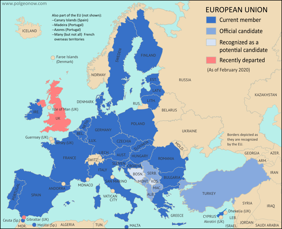
what is a formal region?
a region that is uniform in whatever trait(s) is being mapped
economic: picture shown; all use a common currency (euro)
social: maps of islamic world
political: could be a country itself, or even a state like florida
environmental: the sahara desert on a map
what is a functional region
regions organized around a central node (focal point) and the relationship is typically based around economics, travel, or communication
ex: airports are nodes that connect to other places. all the places it connects to are the functional region but nothing else

what is a perceptual/vernacular region
regions based on a person’s perspective or perception of a certain location
informal; can be based on sense of place and cultural identity; boundaries often vary because people have a different sense of what defines and unites a region
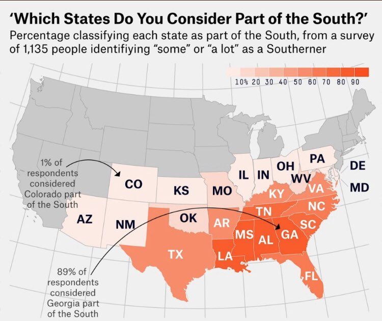
environmental determinism vs. possibilism?
environmental determinism: the belief that climate and landforms are the most powerful forces shaping human behavior and societal/cultural development; environment determines success of a society
possibilism: acknowledges the limitations imposed by the natural environment, but focuses on the role of human culture to modify and respond to the environment to better fit human needs
humans can modify environment to support them
what are some examples of possibilism?
building dams or bridges
air conditioning
terrace farming
irrigation projects
screened porches and breezeways
basically anything you can see is a result of humans trying to mitigate environmental factors
what are scales of analysis?
the level at which data is being presented
smallest to largest: census tract (neighborhood) < city/local < county < sub-state/state (florida) < state/country/national < regional (bigger than a country) < global
how do scales of analysis impact the results of a study
changing the geographic "zoom level" can reveal, hide, or completely alter spatial patterns and conclusions
broader levels (national, regional, etc.) can hide local inequalities/opinions
the process of a cartographer showing the curved surface of the earth on a flat surface (map)
map projection
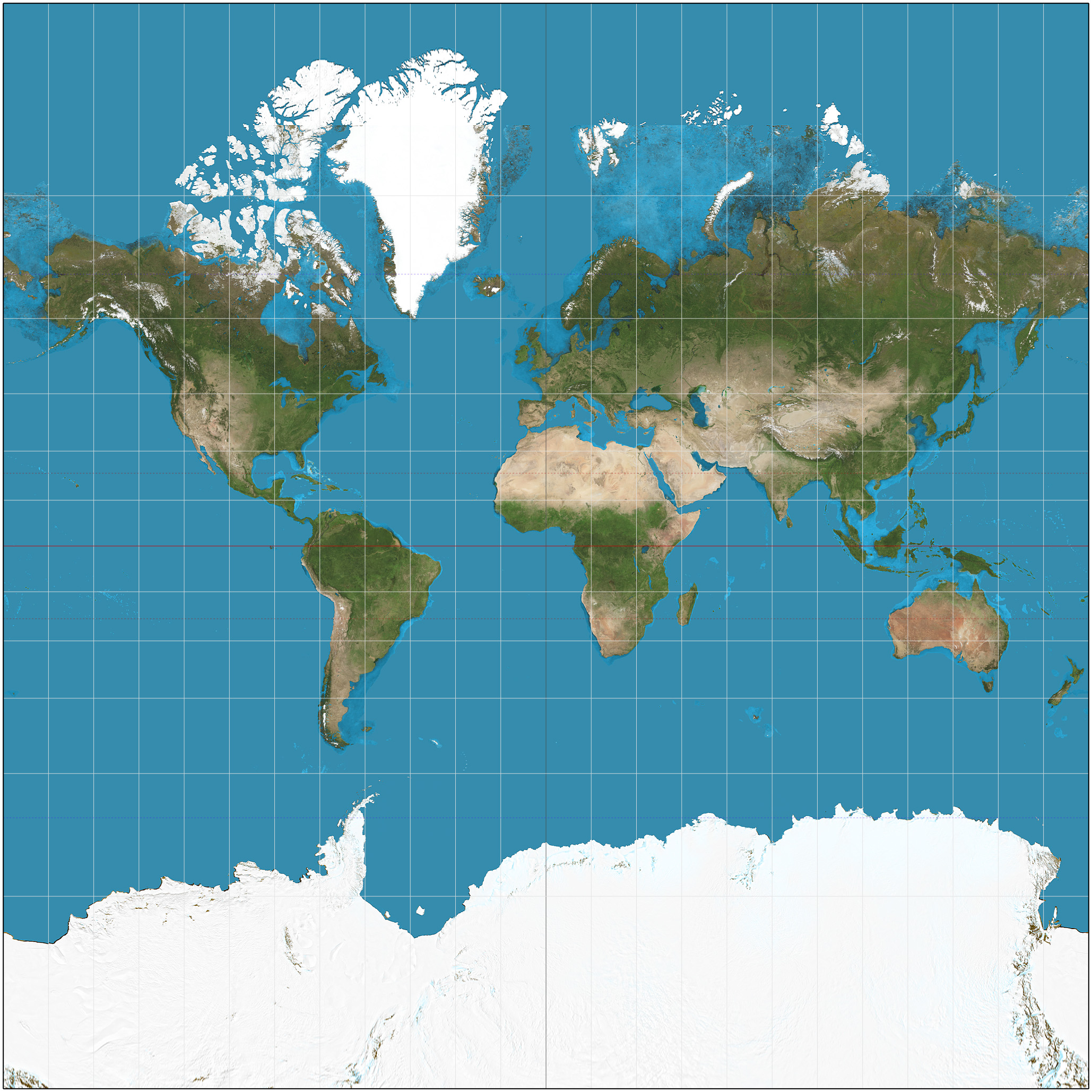
what map is this? what are its advantages and disadvantages?
mercator map
advantages: used for direction and shape; it preserves right angles of latitude and longitude, so it is good for naviagtion
disadvantages: area distorted near the poles (shows greenland and africa to be the same size, but this is not true irl); increases size of high latitude areas
map scale vs. scales of analysis?
map scale: the mathematical ratio between distance on a map and the actual distance on the ground
scale of analysis: the observational level or geographic grouping (such as local, national, or global) used to organize and interpret data
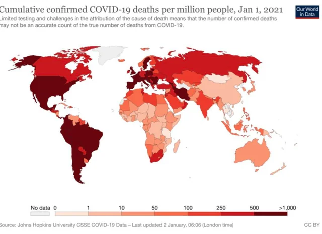
what is the scale of analysis of the data? how do you know?
national, because it shows the amount of deaths per nation
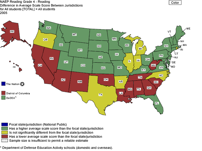
what is the scale of analysis of the data? how do you know?
sub-state, because it shows the data for each state in the u.s.
how is geographic data collected?
fieldwork: the act of physically visiting a location or place and recording the information there
can be in-person or census