Looks like no one added any tags here yet for you.
Lithosphere
Crust and rigid upper mantle
Asthenosphere
Flowing mantle layer, moved by convection currents
Layers of earth- Top down
Crust: continental and oceanic,
mantle: peridotite (iron, magnesium, silica)
Outer core: liquid iron, nickel, possibly oxygen
Inner core: solid iron due to high pressure
Continental Crust
low-density granite (rich in silica and aluminum), older, 20-70km thick
Oceanic Crust
Mostly basalt (rich in iron and magnesium), high density, younger, 6-10 km thick
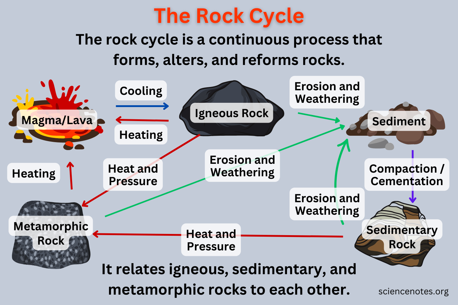
Rock cycle
Shows transitions btwn rock types, driven by hydrological cycle and earth’s internal heat engine, demonstrates geologic history and rock interconnectivity
Mineral
-naturally occurring pure substance
-specific elemental composition
-3d repeating structure
Rock types
Igneous: form from cooled magma (slow-granite, fast-basalt)
Sedimentary: form from compressed rock fragments (sandstone, Limestone)
Metamorphic: form from altered igneous/sedimentary rocks under heat and pressure (marble, schist)
Mineral classes:
Sulfide
Oxide
Silicate
sulfate
halide
carbonate
phosphate
native element
Some Old Scientists Study Hard Crystals Passionately, Naturally."
Sulfide
Oxide
Silicate
Sulfate
Halide
Carbonate
Phosphate
Native elements
Sulfide: S and metal
Oxide: O and metal
Silicate: Si + O + R
Sulfate: S + O + metal
Halide: Halogen anion (F, Cl, Br, I)
Carbonate: CO3 and metal
Phosphate: PO4 + R
Native elements: Ag, Au, Cu, C
Characteristics used to identify minerals
Cool Scientists Love Collecting Hard Crystals, Discovering Textured Glowing Formations
Color
Streak
Luster
Cleavage
Hardness
Crystal Structure
Density
Texture
Grain Size
Field Relationship
Color
Streak
Luster
Cleavage
Hardness
Crystal Structure
Density
Texture
Grain Size
Field Relationship
Color- varies due to trace elements
Streak- powder left on unglazed porcelain reveals true color by removing surface variability
Luster: Way light interacts with surface, metallic, glassy, earthy, pearly
Cleavage: Breakage along planes, determined by weaknesses in atomic lattice
Hardness: ability to resist deformation (mohs scale 1-10)
Crystal Structure: determines mineral shape
Density: varies based on atomic structure
Texture: shape/distribution of mineral grains
Field relationships: nearby rocks provide clues about type and origin
Geologic history: Eras
Precambrian era (4.6 bya- 542 mya)
Paleozoic (542-250 mya)
Mesozoic (250-65 mya)
Cenozoic (65 mya- present)
Please pay my cat
Geological periods:
Poor Charlie Often Sings Dreadful Covers, Perhaps To Just Create Pretty New Quilts
Precambrian:
-Hadean Eon
-Archean Eon
-Proterozoic Eon
Paleozoic:
-Cambrian
-Ordovician
-Silurian
-Devonian
-Carboniferous (Mississippian and Pennsylvanian)
-Permian
Mesozoic:
-Triassic
-Jurassic
-Cretaceous
Cenozoic
-Paleogene
-Neogene
-Quaternary
Precambrian Era
4.6 BYA-542 MYA
Hadean Eon: Earth and moon formed
Archean Eon: Plate tectonics, origin of life
Proterozoic Eon: O2 in atmosphere, sexual reproduction, photosynthesis
Paleozoic Era:
542 MYA-250 MYA
-Cambrian Period: Cambrian explosion, first vertebrates
-Ordovician period: pangea formed, first land plants, mass extinction
-Silurian period: 1st jawed fish, ozone layer
-Devonian Period: 1st forests, seeds, soils, insects and spiders, tetrapods, mass extinction
-Carboniferous: Mississippian: amphibians, limestone formations. Pennsylvanian: conifers, coal-forming swamps
-Permian period: mammal ancestor, 95% mass extinction
Mesozoic Era
250-65 MYA
Triassic: reptiles dominant, pangea starts separating, mass extinction
Jurassic: first birds
Cretaceous: angiosperms, rocky mountains, chalk cliffs of over, dino-killing asteroid
Cenozoic Era
65 MYA-Present
Paleogene: mammals diversify, Himalayas form
Neogene: Grasslands develop, hominids emerge
Quaternary: Ice ages, modern humans, megafauna extinct
Alfred Wegner
Continental drift theory, pangea, plate tectonics
Paleomagnetism
Evidence of variations in earth’s magnetic field
Magnetic anomalies indicate pole shifts
Fe rich minerals in cooling lava align with magnetic field. Preserve field orientation once solidified.
Evidence suggests multiple field reversals
Tectonic/lithospheric plates
14 crust sections floating on earth’s fluid mantle
move 1-15 cm/ yr
Possible mechanism: thermal convection currents in asthenosphere
Collisions lead to mountains and volcanic activity
Earth with no tectonic activity
no new mountains or volcanoes
erosion would flatten and submerge land
no >7 earthquakes
loss of magnetic field leads to atmospheric loss and ocean evaporation
Subduction zones
-dense oceanic crust subducts beneath continental crust
-subducting portion melts as it enters asthenophere
-accretionary wedges form from scraped off material
3 means of mountain formation
Continental convergence:
Subduction
Hot spot mantle plumes:
Continental Convergence
-continental plates collide, crust is crumpled and uplifted
Subduction
-oceanic crust subducts under continental crust
-scraped off material can form mountains
-parallel to accretionary wedge, under continental crust, subducting plate releases hot water, melting rock and creating magma, forming volcanic arc on continental crust
Hot spot mantle plumes
-buoyant magma released from mantle
-erupt as volcano
-carried away from hotspot by moving plate
-volcanoes can become inactive mountains or eroded to form island chains
Life cycle of a Hawaiian island
Deep submarine stage
Shallow Submarine stage
Shield-building stage
Post-Shield stage
Erosional Stage
Rejuvenation stage
Reef-growth stage
Atoll Stage
Guyot (Seamount stage)
Deep submarine stage
-rapid growth because buoyant force of water allows magma to amass at top near extrusion point. >300,000 years
3 components of magma
oxygen, silicon, aluminum
Factors affecting magma viscosity
pressure, temperature, silica polymerization (as temperature drops, silica tetrahedra form and polymerize increasing viscosity), Magma is liquid at >1300 C
Explosive vs Effusive eruptions
Effusive: minor, localized, predictable,
Explosive: eject ash, toxic gas and debris. Quick emptying can cause collapse. landslide and tsunamis.
Role of Gases and Viscosity in explosive eruptions
Less silica: less viscous. erupt in steady flow, gasses can escape-effusive eruption
High Viscosity: under high pressure, gases can’t escape. pressure increases until volcano breaks-explosive eruption
Felsic Rocks
high silica composition, made of light colored minerals like quartz, feldspar, and muscovite mica.
Mafic Rocks
low silica composition, made of dark colored minerals like olivine and biotite
Rhyolite
volcanic, felsic, extrusive. Pink with very fine crystals
Andesite
extrusive, intermediate. Equal amounts of felsic and mafic minerals. Grey, crystals= porphyritic
Basalt
extrusive, mafic.
dark grey, fine grained, porous
phenocrysts=olivine or plagioclase
Pahoehoe v A’a
Pahoehoe: solid sheet of lava
thin surface layer of volcanic glass
extensions=toes
flows smoothly until it drops off and tumbles, breaking into pieces
A’a: rough elements or various sizes. Formed when pahoehoe drops
Volcanic Glass
Columnar Lava
Pillow Lava
Volcanic glass: dark, shiny, opaque product of rapidly cooling basaltic lava
Columnar Lava: upright hexagonal prisms formed by slow cooling and contraction of thick lava flows. 90 degrees to coolest surface
Pillow lava: round masses of hardened lava that extruded into water and quickly hardened without causing steam explosion. Indicate volcano was aquatic at time of eruption.
Shield Volcano
Composite volcano
Calderas
Cinder Cones
Lava Domes
Shield volcano: broad, convex shape. flat summit region. largest volcanoes by volume
Composite volcano: cone shaped. made of alternating strata of solid lithic material and fluid lava at continental plate subduction zones
Calderas: large craters around summit caused by eruption, then collapse
Cinder cones: most common type. steep cones topped by summit crater
Lava domes: small, steep, rough sided
Cascades
subduction, then molten material erupted through continental rock to form a line of volcanoes parallel to coast
Convergent plate boundary eruptions are more explosive
subduction zone/convergent plate boundary eruptions have a higher gas content, which contributes to increased pressure
pressure causes lava to erupt explosively and be carried higher in air
lava is more viscous
at divergent plate boundaries, some lava is used to replace plate material that moved away
Rifting and landslides
heavy volcanic material pushes island down into crust, creating rifts and fault lines
slumps and landslides make up most of islands mass
Bowen’s reaction series
Top: all minerals are molten at 1250c and 1 atm
Bottom: all minerals are solid at 700c and 1 atm
olivine is at top, crystallizes at high temp
Discontinuous: mineral changes at specific temp and constant pressure
Continuous series: changes gradually as conditions are altered
Crystalline structure gets more complex as temp decreases
Lava tubes
Formation: peripheral surfaces of lava cool, inner portion stays hot and fluid.
Trade winds
unequal solar radiation heats equatorial air, driving hadley cell system.
rising air moves toward poles, sinks back to surface at 30 lat, returns to equator
earth’s rotation causes air in N hemisphere to flow from NE-SW otw back to eq, creating NE trade winds- Coriolis effect
Weathering:
-Mechanical
-Chemical
Weathering: the means by which rocks become sediment
-Mechanical: rocks break into smaller pieces due to interactions with ice, water, wind, or other rocks. Increases SA, accelerates chemical weathering
-Chemical: reactions change one type of mineral into another. Allows minerals to become stable at surface.
Ocean tides:
-Spring tides
-Neap tides
Ocean tides:
-moon’s gravity pulls seawater, creating tidal bulges and lowered water on either side- second bulge 180 away
-earth’s revolution pulls land masses thru the bulges and valleys of water, causing tides to rise and fall
SPRING TIDES:
high tides created when moon, earth, and sun are aligned. Suns pull increases size of bulge opposite moon.
NEAP TIDES:
low tides created when sun is 90 degrees to earth and moon
Waves:
Waves: wind and storms move water
little E is lost as a wave travels because affected water only moves a small distance
Feeling bottom- wave motion reaches a depth of half a swell’s wavelength. frictional drag slows swell so crests move closer together and get taller until water collapses as a breaker.
Undertow
Rip Currents
Undertow: backwash of waves moving onto beach, easier to feel in shadows
Rip currents: outward flow of water parallel to shore until a bottom irregularity causes them to flow out to sea.
SAND:
White
Black
Green
White- continental: quartz. Oceanic: calcium carbonate from coral and calcareous algae
Black- contact between lava and seawater creates a steam explosion and particles coated in volcanic glass
Green- fragmented olivine crystals created from erosion of Pu’u Mahana
Shoreline lithic features:
-Sea Stacks
-Blowholes
-Nips
-Sea Cliffs
Sea stacks: Islets formed from partially submerged basalt ridges.
—waves erode part of it, creating a sea cave
—cave extends thru ridge until it forms an arch
—arch roof collapses, remaining portion forms sea stack
Blowholes: roof of a sea cave develops an opening that leads to surface
—waves fill cave or tube, air is compressed, water and air erupt
Nips: sea lvl notches in shore rock caused by waves at constant height hitting rock over a long time
Sea Cliffs: inland part of a nip increases. Rock above collapses and is washed away.
Water’s heat capacity and Hawaii’s climate
water heat capacity moderates temperature adn increases humidity.
pcean absorbs heat by day and releases it at night
heat stored in ocean- evaporation-humidityand rainfall
ocean holds heat from summer radiation
Prevailing trade winds
blow northeast across Hawaii, present most days. gentle and consistent. usually under 25 mph
North pacific high
high pressure systems NE of north pacifc high generates eastward moving storm track
During summer NPH shields Hawaii from storms, not in winter
when low is near hawaii, it causes Kona storms and cold front storms
The inversion layer
the reason there is little rainfall on Hawaii mountaintops.
dry air descends after ascending above the eq and moving N due to hadley cell.
warms as it descends, creating layer with war, atop cold
usually present, weakest during winter (rains then). Prevents precipitation above itself by preventing wet tradewind air from descending
Hilo vs Kailua rainfall
hilo is on eastcoast. trade winds that blow over it are blocked by mauna loa and mauna kea, forcing air to rise and cool above hilo- precipitation. Mountains create upward convection current as they warm, bringin in moist ocean air. Kailua is at similar elevation and position to hilo, but nearest range is smaller and lower
island rainfall:
16% runs off into ocean, 44% evaporates, the rest permeates into groundwater and becomes part of basal lens
Basal lens
-fresh groundwater that floats atop saltwater, permeating base of island
-thickest at abocve sea level at island center, thinner and lower near coast
-hydrostatic pressure created by differnc in elevation causes freshwater discharge from subaerial adn submarine springs
-at equilibrium when amount lost to ocean=amount added
-some heated by volcanic activity and becomes hot springs
Groundwater
-porosity
-permeability
-perched water
porosity: quantity of gaps or pores between bits of sediment that allow water to enter
permeability: when pores in a substanve are sonnected and unobstructed, allowing water to move thru
layers of caldera-fillin
Perched water: water that collects in low-permeability area, can be extractd thru wells or tunnels
Soik and rainfall
More rainfall-may be more fertile, could be leeched
-well-draining can prevent swamp
-arid mountaintops may be more rich in salts and water soluble minerals
-fertile and well-drained=good for crops