6.3 THE CHANGING STRUCTURE OF URBAN SETTLEMENTS
1/32
There's no tags or description
Looks like no tags are added yet.
Name | Mastery | Learn | Test | Matching | Spaced | Call with Kai |
|---|
No study sessions yet.
33 Terms
Name the two groups of factors that affect the location of urban activities
market forces (economic)
Local or central government planning decisions (political)
Explain how market forces can affect the location of urban activities
The demand and supply of land in various locations dictates its price (links to bid-rent theory)
In additions the cost of buying or renting land or premises, local taxes come into play: taxes levied on premises in CBD are high and companies need to ensure they will make enough profit to cover these extra costs
Explain how local or central government planning decisions can affect the location of urban activities
planners can overrule market forces where they consider it necessary for the public good. Govt. may be able to decide, within certain constraints, where the locations of public housing, open spaces, schools, hospitals should be
Under extreme conditions, govt. can issue compulsory purchase orders
In UK green belt policy has limited urban sprawl
Ex-soviet bloc countries have been affected by control from central government
State and give examples of physical factors that can affect the location of urban activities
cities which developed as ports often had their original growth point near to the waterfront and this developed into its CBD e.g. Chicago
Defensive cities are sometimes cramped and the CBD has grown just beyond the original site e.g. Edinburgh on a volcanic plug
Flat land, especially if the city is avoiding steep slopes e.g. Cape Town, South Africa
Avoidance of marshy land, in the tropics this might be insect infested e.g. Dharavi in Mumbai
Islands restrict growth and create high density populations e.g. Hong Kong
State and give examples of transport routes (socio-economic factors) that can affect the location of urban activities
intersections of routes attract services
Cities which are compact and have buildings close together are easier to serve by public transport e.g. Hong Kong
Cities that are more spread out with lower building densities are dominated by cars e.g. Los Angeles
Land use models: growth in sectors is along main transport routes from the CBD outwards
CBD:
Stands for?
Features that identify the CBD
Why is it located there?
Central Business District
High/multi-storey buildings
Expensive land values
Department stores
Shopping
Cultural/historical buildings (museums, castles)
Bus and railway stations
Finance, banks, offices (business sector)
Central location for road/railways to converge
The most accessible location for workers
Accessible to most people for shops and businesses
Name factors influencing CBD decline
City centres are perceived as dirty, unsafe, with an ageing environment and poor infrastructure
Rise in car ownership leads to increased personal mobility
Planning policies can encourage urban expansion (out of town)
Companies and customers find peripheral locations cheaper
Costs of development and upkeep of CBDs are high (business rates, rents, land costs)
Reduced accessibility due to congestion
Explain changes to retailing in urban locations
In HICs smaller shops, which could not afford the high rents of the CBD left long ago
Outward growth of the cities has meant people live some distance from the CBD and the growth of suburban retail and business centres help to provide for these people
Urban super stores are located at points of high accessibility - away from the CBD, near road intersections
Many larger retailers have also moved:
to inner city brownfield sites
to greenfield sites in the suburbs or the rural-urban fringe where retail parks and out of town shopping malls have been built
Growth of online shopping has led to further decline in the CBD
Global recession has caused the closure of shops
State problems that have occurred due to the decline of retailing and the possible solutions
PROBLEMS:
Empty units = potential businesses are more reluctant to locate in any area that is going downhill
Streets go in and out of fashion in CBDs
Clustering of certain shops and services may repel other businesses
SOLUTIONS:
Speciality markets
Street entertainment
Improved/lower cost/free parking
Pedestrianisation, shopping malls and visual improvements
Explain changes to services in urban locations
HEALTH:
tendency in many countries to invest in larger hospitals and health centres in order to achieve economies of scale = closure of smaller local hospitals and clinics → people have to travel further to reach nearest hospital
EDUCATION:
primary schools tend to remain local, secondary schools are provided in larger schools = increased distance between said schools = longer travel times → travel congestion
SPORT:
Redevelopment of sports stadia = move from inner city to a suburban due to shortage of space and congestion in inner-city locations.
Explain changes to manufacturing in urban locations
the compact nature of towns and cities during the Industrial Revolution resulted in a concentration of manufacturing industry in the inner cities → factories located near canals and railways and workers lived walking distance
Industrial buildings of nineteenth century shut down as were unsuitable for modern manufacturing
Intensive nature of land use results in manufacturing sites being hemmed in by other land users preventing on-site expansion
High level of competition for land in urban areas has pushed up prices to prohibitive levels for manufacturing industry in many towns
Planning policies to clear slum area in 1950s, 60s and 70s cleared old industry too
Planning restrictions prevented further development of industry in the inner city
Regional economic planning has offered incentives to encourage industry to relocate to other areas
State advantages to industry of a suburban location
The labour force had moved to the suburbs, with the development of public transport and later the private car
For some industries, population movement also meant a locational shift to their markets
Land prices and rents are usually lower in suburban locations
Newer industrial areas closer to the outskirts of the city were preferred with good access to road transport.
Quality of life is perceived to be higher in suburban locations
State problems that have occurred due to the traffic and the possible solutions
PROBLEMS:
Traffic congestion
Pollution
Accidents
SOLUTIONS:
Emission charges
Restriction according to number plates
Invest in more public transport
Bus lanes
Park and ride
Smart lanes to increase flows in/out of day depending on time of day
Define functional zonation as applied to urban settlements?
Functional zonation is where different land-uses and activities are found concentrated together in certain parts of the urban area, with other functions not found, under-represented or excluded
Define functional zonation as applied to urban land-use?
Functional zonation is the dominance of one function or land-use over others spatially so that observable clusters or associations exist in different areas of towns and cities
Advantages and disadvantages of functional zoning
Advantages: time or cost saving for the function: aids the consumer, reduces pollution
Disadvantages: increased competition for businesses, further to travel for consumers
What is the Burgess Model?
A model that splits urban areas into 4 categories: CBD, Inner city, Inner suburbs, outer suburbs
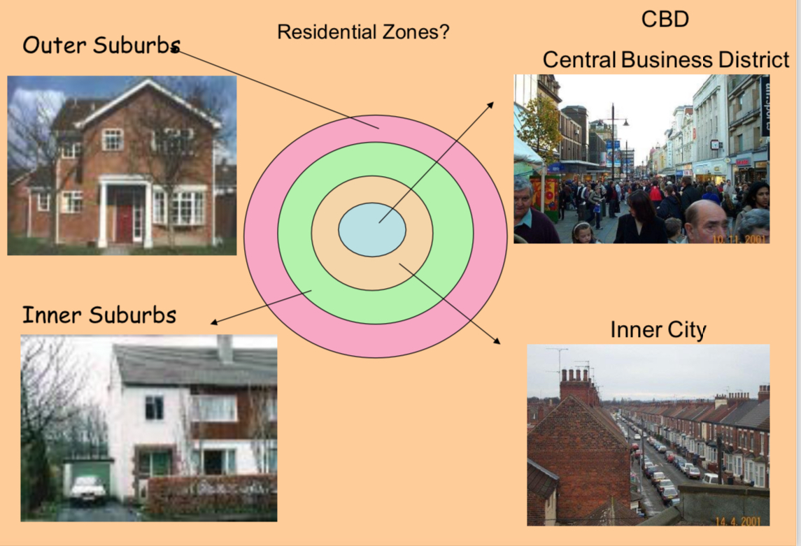
Advantages and criticisms of the Burgess Model
Advantages:
easy to understand
Clearly identifies zones
Criticisms:
too many assumptions: uniform land surface, development moves outward from CBD
Natural features?
Transport?
Why does spatial competition occur in urban areas?
urban locations are desirable, especially central ones and easily accessible ones because of market potential and profitability
Space within urban areas is limited, especially central space
Retailers bid for space and the highest bidder gains the use of that space
What is the Bid Rent Theory?
Concentric rings of land use form due to ability for different types of economic activity to pay for the land
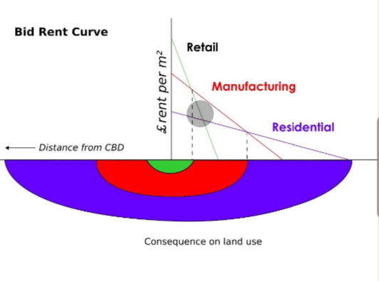
What 3 ideas is the Bid Rent Theory based on?
Land would be occupied by the land use that could afford to pay the highest rent
Land values would decrease from the city centre outwards
Shops and offices would be able to afford the highest rents, followed by industry, followed by residences
Advantages and criticisms of the Bid Rent Theory
Advantages:
clear to understand
Links land price to zones
Criticisms:
residential areas in city centres too: high rises → penthouse, high prices
Internet: people shop online so retail can’t afford high rents
Local centres for shopping in residential areas
Photo of the Hoyt model
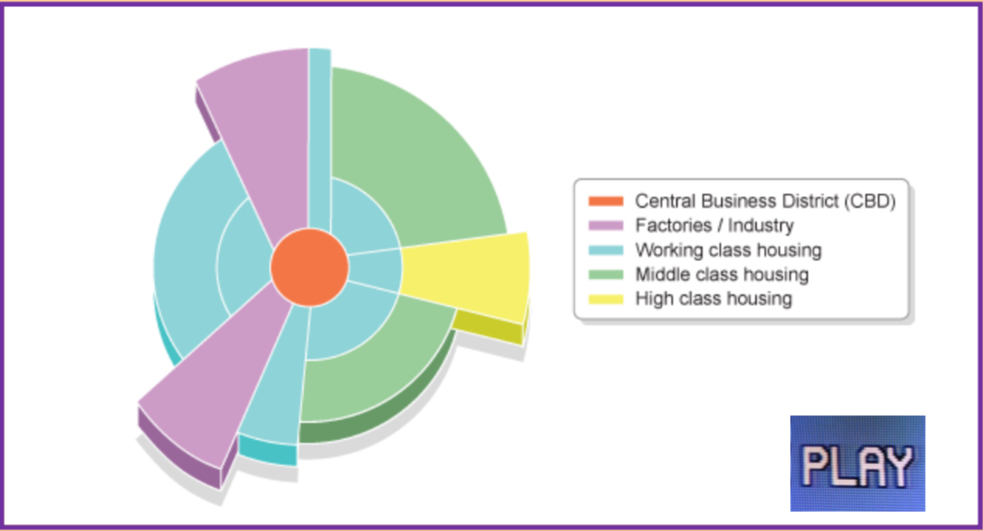
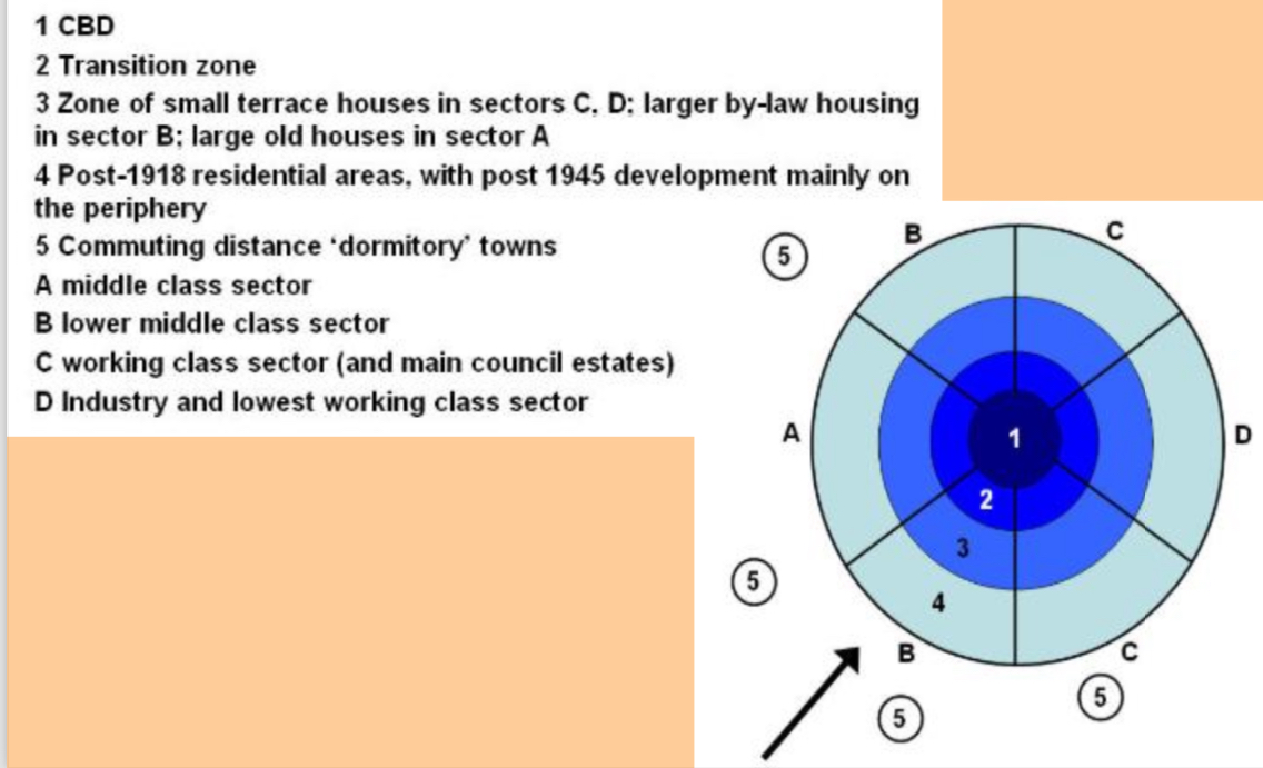
Photo of the Mann model
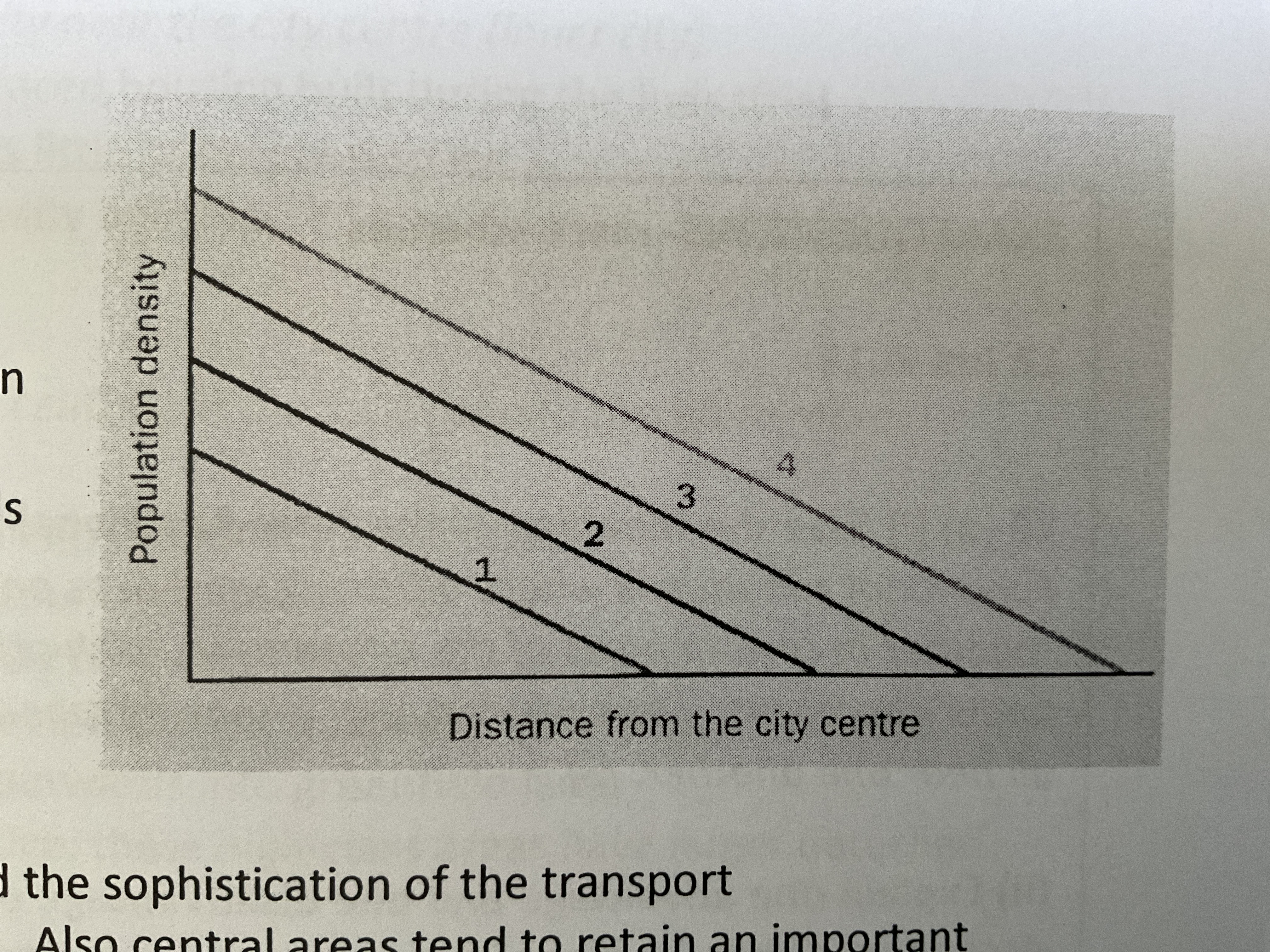
Explain the urban density gradients in cities in LICs/MICs?
In LIC and MIC cities:
continual rise over time in central population density
Stable gradients as the city extends outwards with increasing density
Personal mobility = central areas retain an important residential function
Sophistication of the transport infrastructure operates at a low level = restricted urban sprawl
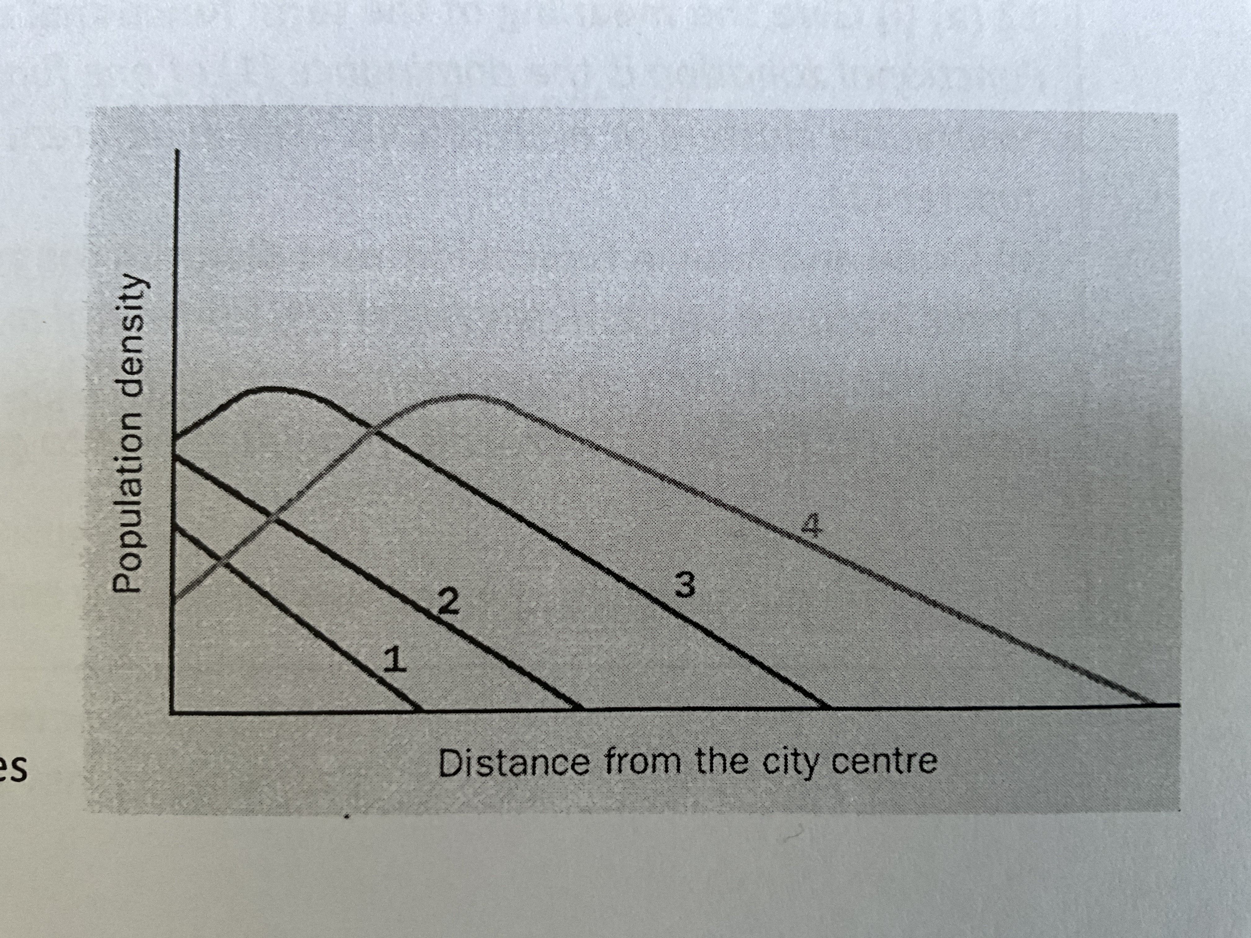
Explain the urban density gradients in cities in HICs?
More complex pattern:
population density reduces as city extends outwards
Population density increases in CBD, then decreases
Population density in inner city residential zones increases, then decreases
The zone of highest population density moves outwards
Recent trends and changes in residential areas
since the 1980s many new houses and flats have been built on brownfield sites, thus regenerating old areas
As house prices increase, there is now a real need for affordable housing
Modern estates in the UK are now often built with a mix of housing styles
Name 4 processes that result in residential segregation
the operation of the housing market
Planning
Culture
The influence of family and friends
Explain how the operation of the housing market and planning can lead to residential segregation
In some urban areas where population is growing housing is in short supply, resulting in high prices and overcrowding at the lower end of the market, so people with lower incomes are gradually pushed out of desirable areas
Access to finance, mainly availability of mortgages, in the efficient operation of the house market
3 main causes of residential segregation
Income
Age
Ethnicity
Explain how income is a cause of residential segregation
People with high incomes = wide choice of where to live, more concentrated in affluent suburbs with large houses and gardens.
People with low income = limited, live in cheaper areas,
Car ownership = restricts lower-income groups to areas of the inner city with cheap public housing.
E.g. inner areas of London specifically Camden
Explain how ethnicity is a cause of residential segregation
Cities have always attracted immigrants and often newer immigrants can only afford the cheaper housing, also want to live near to people from their own culture and speaking their language.
Conflict may arise between immigrant communities and the native population or between different immigrant communities
Explain how age is a cause of residential segregation
Location and type of property is often affected by someones age and family size.
Young people = rent small flats
Families with children = need more space, buy largest properties they can afford
Older people = often ‘trade down’ to a smaller property when their children leave home, single storey housing