Hydrology and Fluvial Geomorphology Flashcards
1/103
Earn XP
Description and Tags
Vocabulary flashcards related to hydrology and fluvial geomorphology.
Name | Mastery | Learn | Test | Matching | Spaced |
|---|
No study sessions yet.
104 Terms
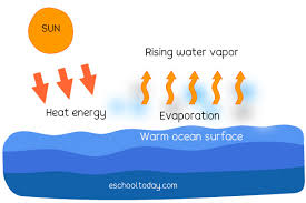
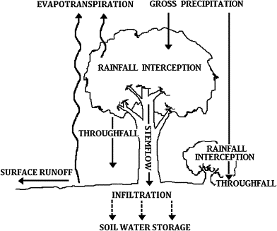
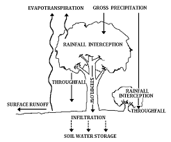
Evaporation
The transformation of water from liquid to gas (water vapor); occurs on surfaces like rivers, lakes, and moist soil and is controlled by temperature, wind, and humidity.
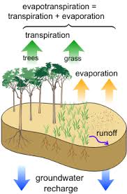
Evapotranspiration
A combination of evaporation and transpiration (water lost from plants leaves stomata); depends on vegetation type, climate, and time of year.
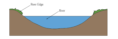
River discharge
total volume of water flowing thoguh a river channel at a specific point in time, measured in cubic meters per second (m³/s).
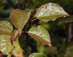
Interception
Water held on leaves and branches, affected by vegetation type (e.g. dense forest intercepts more than grasslands)
Surface Storage
Water held in puddles, lakes, and reservoirs. Storage increases if rainfall is more than infiltration capacity.
Soil moisture / soil water
Water stored between soil particles, determining how much water can infiltrate further. Saturated soils lead to more surface runoff.
Groundwater Storage
Water stored in aquifers, the permeable rock beneath the surface, and is important for dry season flows (baseflow).

Channel Storage
Water held in rivers and streams.

Throughfall
Rain dripping through leaves to the ground.
Stem flow
Rain running down stems/trunks.
Overland Flow
Water flows over the surface, often when soils are saturated or impermeable.

Channel flow
Water movement within the river channel.

Infiltration
Entry of water into the soil from the surface through pores, could be made by animals like worms; influenced by the nature of soil, vegetation, and antecedent moisture.

Percolation
Downward movement of water into drainable rocks; recharge rates are lower than infiltration.

Through Flow
Lateral movement of water within the soil, above an impermeable layer, through the unsaturated zone. Faster than groundwater flow and contributes to river flow.
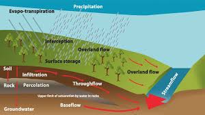
Groundwater Flow
Water moves slowly through saturated rock aquifers, maintaining river flow in dry seasons.
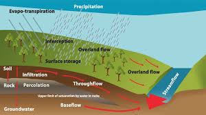
Baseflow
Portion of groundwater that flows into rivers gradually; critical for ecosystems during dry periods.

Water table
Upper limit of saturation in the ground that can rise or fall with rainfall or drought; often shallower in wetlands and deeper in deserts.
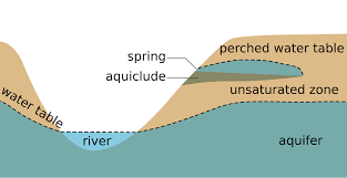
Groundwater
Water stored in pores and cracks below the water table, often stored in aquifers; can be fresh or saline.

Recharge
Replenishment of groundwater via percolation from rainfall or rivers, or artificial via injection wells.
Springs
Natural outflows of groundwater where the water table meets the surface; often found on valley sides or fault lines and can feed perennial streams.

storm hydrograph
A graph that shows the flow rate of a river over time in response to a storm event.

Peak rainfall
Time of maximum rainfall.

Lag time
Time between peak rainfall and peak discharge.

Falling limb
Rate of decrease in discharge after the peak.

Rising limb
How quickly discharge increases after rainfall.

Base Flow
Normal river flow before a storm.
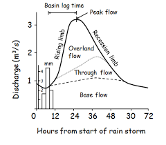
Storm flow
Base flow in the river during the storm.
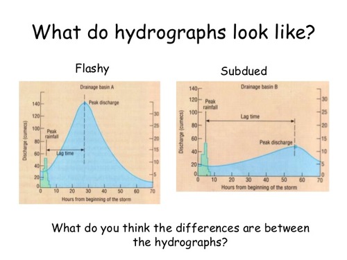
how flashy precipitation affects strom hydrograpgh (lag time, rising limb, peak discharge, risk, causes)
lag time - short
rising limb - steep
peak discharge - high
high flood risk
causes - urban land, saturated/impermable, heavy/intense rain, steep slope, vegetation cover, high temperatures, antecedent moisture, precipitation type/duration.

how subdued precipitation affects strom hydrograpgh (lag time, rising limb, peak discharge, risk, causes)
lag time - long
rising limb - gentle
peak discharge - low
lower flood risk
causes - foreseted, permable, light rain, gentle slope
drainage basin characteristics
basin size - larger vs smaller (smaller basins respond quicker)
basin shape - circular vs elongated (elongated basines produce longer lag times)
drainage density - more channels mean more water getting to the drainage basin (high drainage density = steep rising limb)
soil type - permeable vs impermeable (clay = more runoff, sandy = more infiltation)
rock type - permeable vs impermable (impermeable rock in urrban areas = high surface runoff compared to rural areas where there is more infiltration)
relief/slopes - steep vs gentle (steep slopes = rapid surface runoff)
vegetation - dense vs sparse (forest intercept rain and delay surface runoff)
land use - urban vs rural (urban areas typically have more impervious surfaces, increasing runoff and agricultural land use can affect infiltration and runoff patterns)
annual hydrograpgh
a graph illustrating the seasonal pattern of river discharge over a year.
influences on annual hydrograpgh (7)
climate patterns (rainy seasons raise discharge compared to dry seasons(monsoon season))
snowmelt (seasonal snowmel causes spring peaks (Colorado river high sprring flow))
temperature variation (affects evapotranspiration warm summer causes more evapotranspiration lowerr river flow)
soil moisture storage (wet winters cause more runoff, dry summers cause more infiltration)
human activity (dams, irrgation, deforestation alterr flow (Niler river controled by Aswan Dam))
agricultural demand (more irrigation in dry seasons reduces discharge)
dam management (releases water during dry seasons to maintain baseflow)
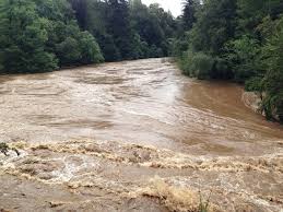
erosion
river eroison refers to the wearing away of the riverbed, banks and load. there are four main types (abrasion, hyraulic action, solution and cavitation)

Abrasion (corrasion)
River loads against the bed and banks, acting like sandpaper. like pebbles grinding down rock in a fat-flowing stream)

Hydraulic action
Fast-flowing water forces air into cracks in the riverbank, weakening and breaking it apart.
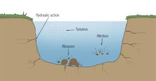
Solution (corrosion)
Slightly acidic water dissolves soluble rocks like limestone.

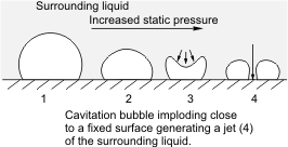
Cavitation
Explosive force of air bubbles collapsing under pressure, releasing energy.
attrition
where particles (rocks, pebbles, etc.) carried by water collide with each other, breaking down into smaller, smoother pieces over time

Traction
Large, heavy pebbles are rolled along the river bed, most common near the source of a river.

Saltation
Pebbles are bounced along the river bed, most commonly near the source.
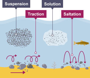
Suspension
Lighter sediment is carried within the water.

Solution
The transport of dissolved chemicals, which varies along a river depending on the presence of soluble rock.

Hjulström Curve
A graphical representation that illustrates the relationship between sediment particle size and the velocity required for erosion, transportation, or deposition.

Erosion curve
The minimum velocity required dislodge particles from the riverbed.
Transportation Zone
Zone where a particle is in motion and can be carried at lower velocities than required to pick it up.
Deposition Curve
The process that occurs when velocity drops below a certain threshold, where particles are dropped from the river.
observations from the curve (5)
sand is easiest to erode (requies least amount of energy because they are light weight but not samll enough to stick together)
clay and silt require high velocities to be eroded (they ae very small but cohesive, so they stick together making it hard to lift)
large particles need high velocity to be eroded ( their mass and size means more energy is needed to lift them from the riverr bed)
transport is easier than erosion (once in motion a particle stays suspended at lower velocties than those needed to erode it)
deposition occurs at low velocities (when flow slows down the heaviest particles drop first then medium then fine, this leads to sorting of sediments where coarses upstrream and finer downstream)
velocity
the speed of water flow in a river or stream, affecting sediment transport and erosion. meausrred in meters per secon (m/s). fastes at surface and center and slower near the banks and bed due to frriction.
factors affecting velocity
gradient/slope (steepr gradient = higher velocity)
channel storage ( more efficient shapes (semi-circular) reduce frriction and increase velocity)
channel roughness (rough beds with boulders and debris slow donw velocity due to increased turbulence)
discharge (more water usually = more energy and a higherr velocity)
obstuction (vegetation, debris, rocks reduce veloccity)
discharge
the volume of water flowing through a river or stream per unit of time, typically measured in cubic meters per second (m³/s).
discharge formula
discharge (Q) = cross-sectional area (A) x velocity (V)
discharge increases when? (3)
from source to mouth
after rainfall event or snowmelt
in wet seasons
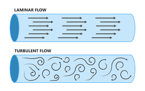
laminar flow
a smooth, orderly flow of fluid where layers move parallel to each other, typically at lower velocities. Found at shallow water, rarely found in nature. Found in slow moving water like groundwaterr or artificial channels.
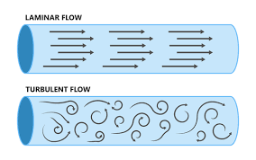
turbulent flow
a chaotic and irregular flow of fluid where layers mix and move independently, often occurring at higher velocities and in deeper water. Found more commonly in nature.
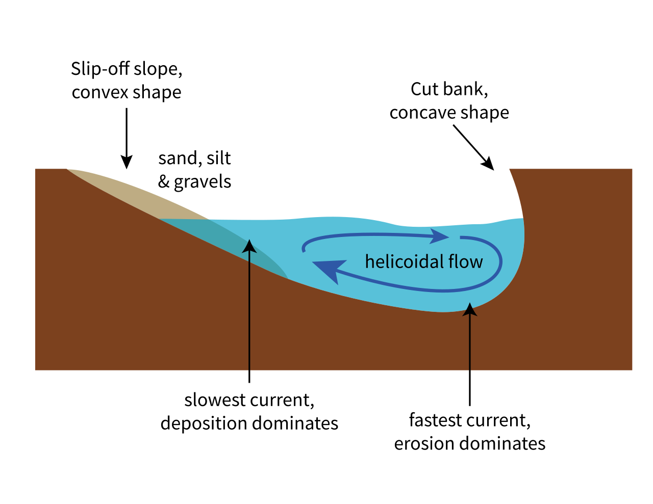
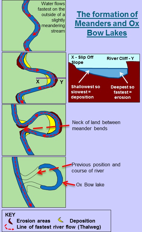
Helicoidal flow
Corkscrew-like flow that moves water laterally across the channel, from the outer bend (erosion) to the inner bend (depostion), especially important in meander formation.
Straight Channels
A river with a relatively linear course; rare in nature, often man-made.
Braided channels
Consists of multiple interweaving channels separated by mid-channel bars or islands made of deposited sediment.
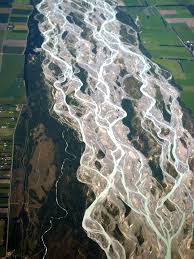
formation of a braided channel (4)
1 sediment supply exceeds the rivers capacity to transport it
2 the river deposits material, forming mid-channel bars
3 the water splits around these bars into smaller channels
4 during floods new bars form and channels shift postion
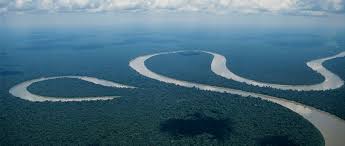
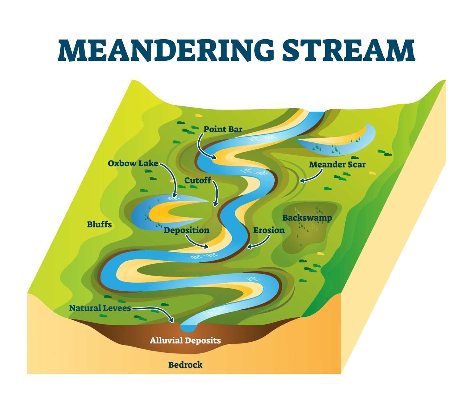
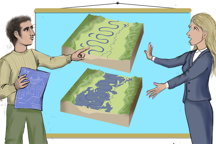
Meandering channels
A single curving river channel, typically found in the middle and lower course of a river.
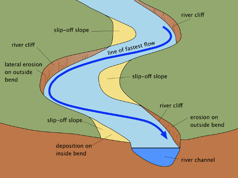
formation of a meandering channel (4)
1 slight irregularities in the riverbed and banks create small bends in the river these bends disrupt the flow and trrigger the development of helicoidal flow, that shifts the thawleg1 A single curving river channel, typically found in the middle and lower course of a river.1 A single curving river channel, typically found in the middle and lower course of a river.
2 as the river adjusts to these bends it begins to develop a repeating riffle-pool sequence
3 the outside banks erode due to the thawleg and helicoidal flow hittting it directly while the inside banks deposit sediment.
4 over time erosion on the outer and band and depostion on the inner bank widen the meander bends.
river cliff
A steep riverbank formed by erosion, often exposing layers of sediment and soil.

formation of a river cliff (2)
1 fastest flow hits the outer banks causing hydralic action and abradion to erode the bank
2 over time, this creates a steep, vertical wall or cliff feauture along the riverbank
point bars (slip-off slope)
Deposits of sediment on the inner bank of a river bend, formed as a result of reduced water velocity.

formation of a point bar (slip-off slope) (3)
1 slower flow on the inner bend lacks enegry to transport load
2 fine sediment like silt and sand are depostied
3 creates a gentle sloping deposit called a point bar
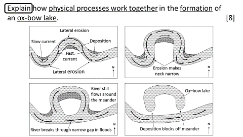
Oxbow Lakes
Crescent-shaped lakes formed when a meander loop is cut off from the main river.
formation of an oxbow lake (4)
1 the riverr meander which has faster flow on the outer bend where erosion occurs and a slower flow on the inner bend where depostion occurs, the combination of these makes the meander more pronounced.
2 continued erosion and depostion gradually narrrows the meander neck, the land between the closet parts of the loops. The rivers course becomes longer and less efficient, increasing the likelihood of a cut-through.
3 during flooding, the river gains energy and may breach the narrow neck, carving a straighter path and the original loop is left behind and becomes a cut-off meander, as the main flow now follows the new more direct channel
4 with the loop abondoned, depostion at both ends of the cut-off gradually seal it off from the main rirver. This forms an oxbow lake, which may dry up except in heavy rainfall
riffles
shallow sections of a river where water flows rapidly over rocks and creates turbulence. Riffles are important for oxygenating the water and supporting aquatic life.
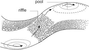
pools
deeper sections of a river characterized by slower water flow, often serving as habitats for fish and other aquatic organisms.

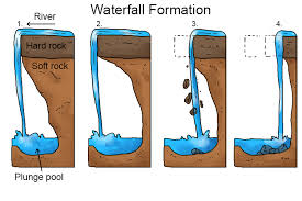
Waterfalls
A vertical drop in the river profile, found in the upper course.
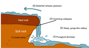
formation of a waterfall (5)
1 occurs when a river flows over a hardened rock layer, utilizing its energy to erode the softer rock beneath it, creating a dip.
2 as erosion continues, a vertical drop is formed, which eventually leads to the plunge pool being formed as falling water and particles contiue to erode the soft rock.
3 the soft rock is undercut by erosinal prrocesses such as hydraulic action and abrasion, depening the plunge pool, wherre water and debris swirl around eroding the rock through corrrasion furthere depedning the plunge pool and creating an overhang
4 hard rock overhangs above the plunge pool after plunge pool collapses as its weight is no longer supported
5 over time, the now fully formed waterfall retreats upstream as erosion continues, creating a gorge
Gorges
A narrow, steep-sided valley formed by the retreat of a waterfall or vertical erosion.
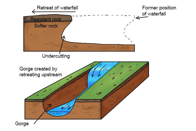
formatioin of a gorge
waterfall retreats upstream overtime a gorge forms
can also forrm through rapid river downcutting during tectonic uplift or glascial melt
Bluffs
Steep-sided bluffs marking the edge of a river's floodplain.
formation of a bluff
a steep cliff or bank created by the erosion of rock and soil, often alongside rivers, lakes, or coastlines.
Floodplains
Flat land adjacent to a river that is periodically flooded and built up by alluvial deposits.
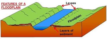
formtion of a floodplain
1 during floods river overflows leading to fine sediments (clay, silt) being deposited
2 over time these deposits build up floodplains
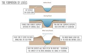
Levees
Natural embankments formed along the edge of a river channel due to sediment deposition during floods. The largest and most coarse material is deposited at the edge of the channel.
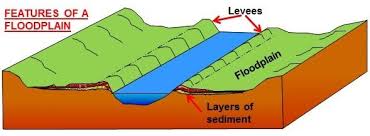
formation of levēes
1 when a river overflows (floods) their banks, they deposit transported sediment due to increased friction with the floodplain
2 as the velocity of the water decreases due to the increased frriction, its ability to transport material is rapidly reduced
3 larger sediment is depostited firrst (coarrse material) often along the edge of the rirver channel whereas finer sediments are transpoted further across the floodplain
4 this results in a high ridge of material or embankment next to the river channel after repeated flooding, known as levee
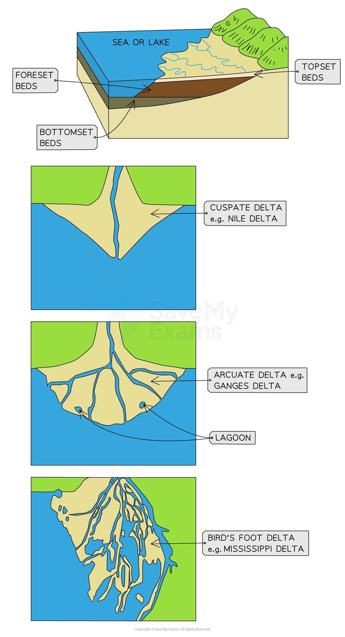
Deltas
A low-lying landform formed where a river enters a standing body of water (sea or lake), depositing its sediment load.
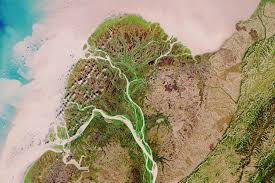
formation of a delta
1 river slows on entering still waterr leads to velocity droping
2 deposition of sediment begins due to not enough energy to transpot sediment
3 river splits into distributaries
4 sediment builds outwards forming a delta
types of delta (3)
Deltas can be classified into three main types: arcuate, bird's-foot, and cuspate, based on their shape and formation processes.
arcuate - fan-shaped, even spread out, Nile river
bird's-foot - extends like a bird's foot, with channels pushing into the water; Missiissippi River
cuspate - triangular shape with pointed ends, formed by opposing currents. tiber river
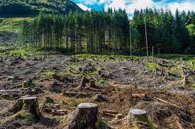
Deforestation (Amazon)
Reduces interception capacity and evapotranspiration; shortens lag time and increases flood risk and soil erosion and sediment in river. long-term can alter local climater and groundwater recharge
Afforestation (Wales)
Increases interception and infiltration; reduces surface runoff, peak discharge, and flood risk; improves soil stability and water retention.

Urbanization (Londons Thames Basin)
Replaces permeable surfaces with impermeable materials, shortens lag time, increases surface runoff, drainage density, and flood risk.
Abstraction (wells, boreholes)
Reduces baseflow and groundwater levels; can cause river levels to drop, drying up smaller channels. In extreme cases can lead to saltwater intrusion in coastal areas
Water storage (Dams & Reservoirs) (1 example)
Alters river discharge, reduces seasonal variability, stores water, slows downstream flow, reduces flooding, may cause evaporation losses, and traps sediment, reducing fetility downstram (e.g floodplain agriculture). e.g. Awan dam on the river Nile has reduced annual flooding and trapped nutrient-rich soils and silt
natural causes of river flooding (6)
prolonged rain
intense rain
snowmelt
impermeable geology
steep relief
climate change

human causes of river flooding (5)
urbanization
deforestation
river mismangement
drainage systems
building on floddplains
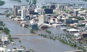
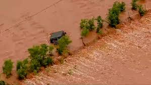
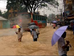
impact of river flooding on people (5)
deaths, injury and diplacement of communities
damage to homes, businesses and infrastructure
disruption to transport and utilites
economic loss (agriculture, tourism and productivity)
phycological stress, long term trauma
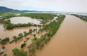
impact of flooding on the enviroment (5)
watterlogging of soil, affecting crop growth
contamination of water sources (from sewage/chemical)
habitat destruction and biodiversity loss
riverbank erosion, loss of fertile land
increased sediment load downstream
predicting floods (2 examples)
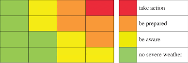
forecasts and warnings - issued by enviromental agencies and meterological services using: weather radar and satellite data, hydrological models, like the annual hydrograpgh, river level sensors and discharge gauges. (the UK enviroment agency issues flood alerts A yellow alert indicates possible severe weather. Amber warnings signal an increased risk of bad weather. Red alerts signify extreme weather)
recurrence level - the statistical measure of how likely a flood of a certain magnitude is to occur in any given year. a “1 in 100 year flood“ has 1% chance each year of happening not one every 100 years (flood defence structures in the UK are typically built to withstand these “1 in a 100 year flood“ plus climate uplift)
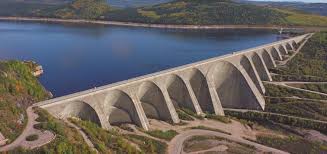
hard engineering (prevent) (5) (advantages and disadvantages plus example)
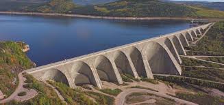
dams - constructed to hold back water and control river flow. its benefits include flood control, HEP, water storage although it has a high cost, displacement of people, sediments trapped and dam collapse.
straightening - removing river meanders to increase flow speed and reduce flooding, its benefits are it helps water exist quickly although it increases flooding downstream and can lead to habitat loss and increased erosion.
levees (embankments) - built alongside rivers to prevent flooding, providing protection to adjacent land, like farmland and settlement. They can increase flood risk if overtopped or fail, and often require ongoing maintenance.
diversion spillways - structures designed to redirect excess water during floods, helping to manage flow and prevent overflow into populated areas or high value areas. Although it is expensive and may bring flooding to other areas.
dredging - the process of removing sediment and debris from river channels to deepen the channel and improve capacity. Benefits include, increases river capacity to carry more water and reduces flood risk in the short term. although temporary solution as sediment builds up again, disrupts aquatic habitats and is expensive and needs regular maintenance.
surge barrier - a structure used to protect against storm surges and floodwaters. Its benefits include protects large, low-lying areas from tidal and storm surge flooding, can be opened for ships and normal tidal flow and a long-term solution for flood risk. Although it isextremely expensive to build and maintain, requires constant monitoring and operation can affect local ecosystems and tidal flow.
A system of levees, storm surge barriers and diversion spillways, protect low-lying land from the Rhine and Meuse rivers in Netherlands
soft engineering (protect) (4)
floodplain zoning - resticts development in high-risk zones of flodding. It benefits are its cost effictive, reduces damage or hazard. Although it is politically difficult and it limits housing
afforestation - planting trees to increase infiltrtion and interception, which can decrease runoff and mitigate flood risk. Its advantages include enhancing water retention in soil and improving biodiversity, while downsides may include the time needed for trees to mature and land use conflicts.
wetland/riverbank restoration - rehabilitating natural ecosystems to restore them back to their original state (restores buffers and slows) improving their ability to absorb floodwaters. This approach can reduce flash floods, increase habitat for wildlife. Requires space and long-term management.
river restoration - reintroducing natural river processes, such as restoring meanders and resoration of natural river plants. This increases storage and slows down water. Although it is costly in urban areas and may cause displacement
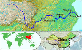
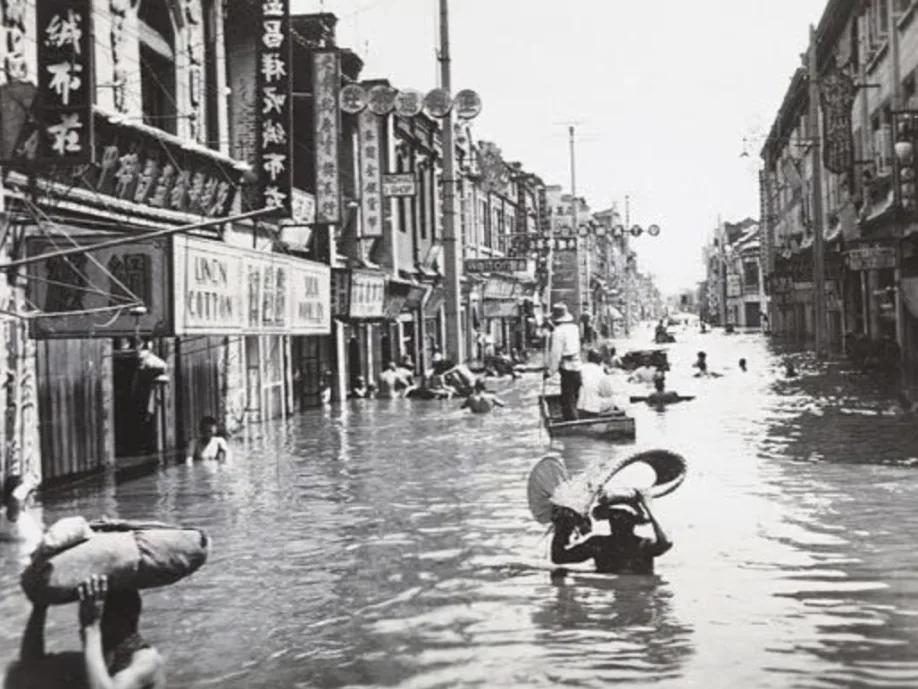
Yangtze river flooding (1998) (background) (3)
The Yangtze river is the third longest river in the world at 6,380 km
Its basin covers 1.8 million km², supports 400 million people and produces 66% of Chinas rice.
The region faces annual monsoon flooding, but the 1998 one marked the worst flooding event in modern history
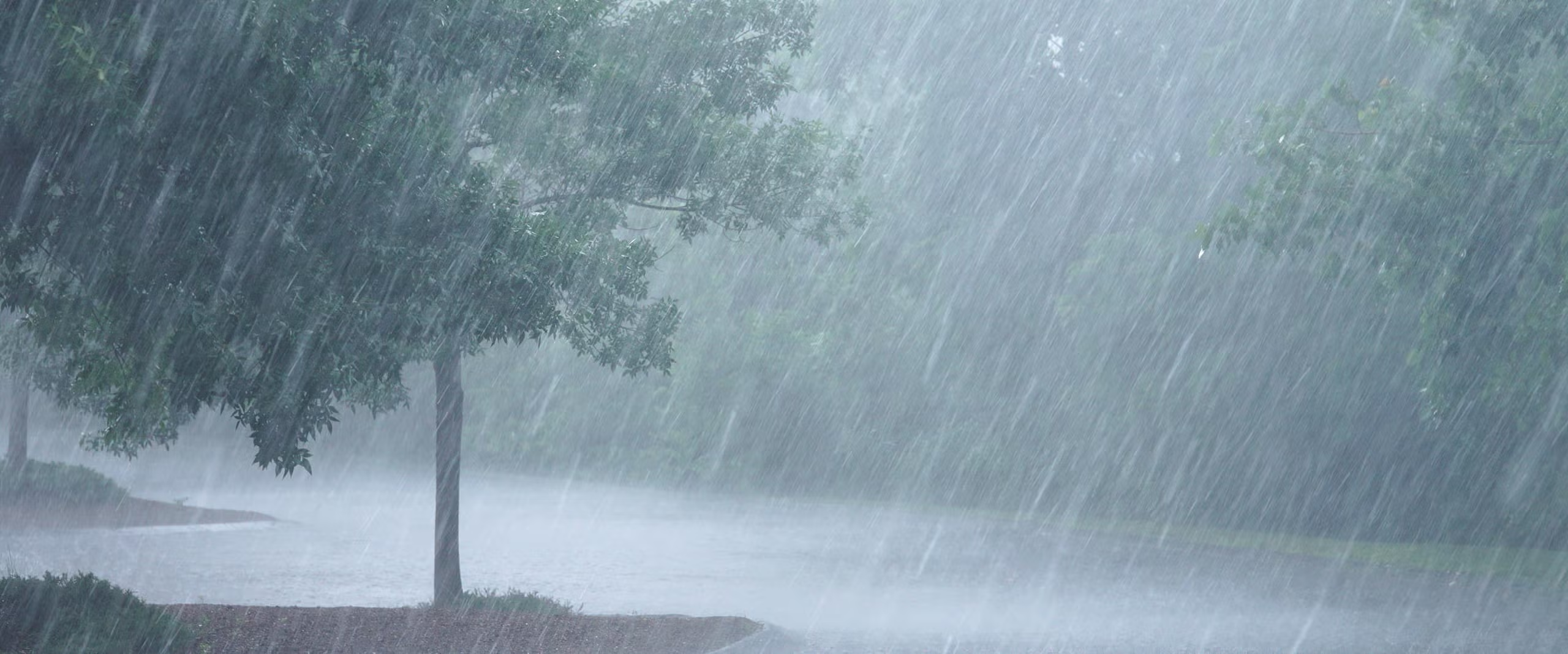
Yangtze river flooding (physical causes) (4)
monsoon rainfall + snowmelt - intense and prolonged precipitation combined with melting snow from the Himalays, leading to excessive runoff and increased river flow.
El Niño (1998) - warm pacific ocean temperatures alter wind and rainfall patterns, extending rainy season.
steep slopes - rapid surface runoff and minimal infiltration
global warming - increased intensity and duration of rainfall events
Yangtze river flooding (human causes) (6)
deforestation
urbanization
channel straightening
polder reclamation (reduced lake size)
hard engineering (levee breakage)
overgrazing (soil erosion increased sedimentation reducing river capacity)
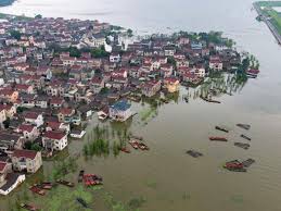
Yangtze river flooding (social impacts) (5)
240 million people affected
4000 deaths, 15 million homeless
1.2 million animals killed
thousand of towns and villages submerged
areas intentionally flooded to protect cities like Wuhan
Yangtze river flooding (economic impacts) (4)
factories flooded and industrial production halted
crops destroyed, agricultural losses severe
transport routes submerged
huge cleanups costs (e.g removing thick clay from fields)
Yangtze river flooding (enviromental impacts) (3)
widespread soil erosion
increased landslide on saturated valley sides
polluted floodwaters impacted ecosystems