Unit 6 APHG
1/70
There's no tags or description
Looks like no tags are added yet.
Name | Mastery | Learn | Test | Matching | Spaced |
|---|
No study sessions yet.
71 Terms
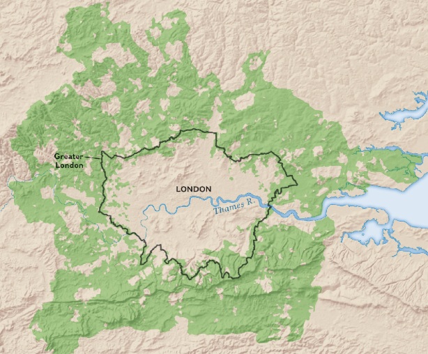
metropolitan area
includes a city and the surrounding areas that are influenced economically and culturally by the city.
site
actual place or location of the settlement and the land on which the city was built
include the landforms, climate, availability of water, soil quality, and natural resources of the land
things located at a place
physical characteristics
situation
refers to the connections between its site and other sites
A city with a favorable situation has easy access to trading partners, resources, and other connections, which fuels growth and economic development
what is surrounded by a place
urban area
defined as a city and its surrounding suburbs
urban sprawl
urban areas expand in an unplanned and uncontrolled way, covering large expanses of land in housing, commercial development, and roads.
The spread of dispersed urban land uses outside compact urban centers into previously rural areas.
the uncontrolled expansion of urban areas into the surrounding rural land, resulting in low-density, car-dependent development patterns
edge city
a type of community located on the outskirts of a larger city
-Edge cities are commercial centers with office space, retail complexes, and other amenities typical of an urban center.
boomburb
suburb that has grown rapidly into a large and sprawling city with more than 100,000 residents
exurb
fast-growing community outside of or on the edge of a metropolitan area where the residents and community are closely connected to the central city and suburbs
low-density residential community; may include wealthy estates or small rural towns
infill
redevelopment that identifies and develops vacant parcels of land within previously built areas
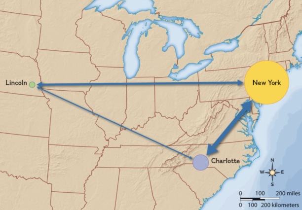
gravity model
Cities have an area of influence based on their size.
The interaction of people and
goods between cities is generally proportional to the product of their populations and inversely proportional to the distance between them.
primate city
a city that far exceeds, in population size and influence, the country’s next largest city.
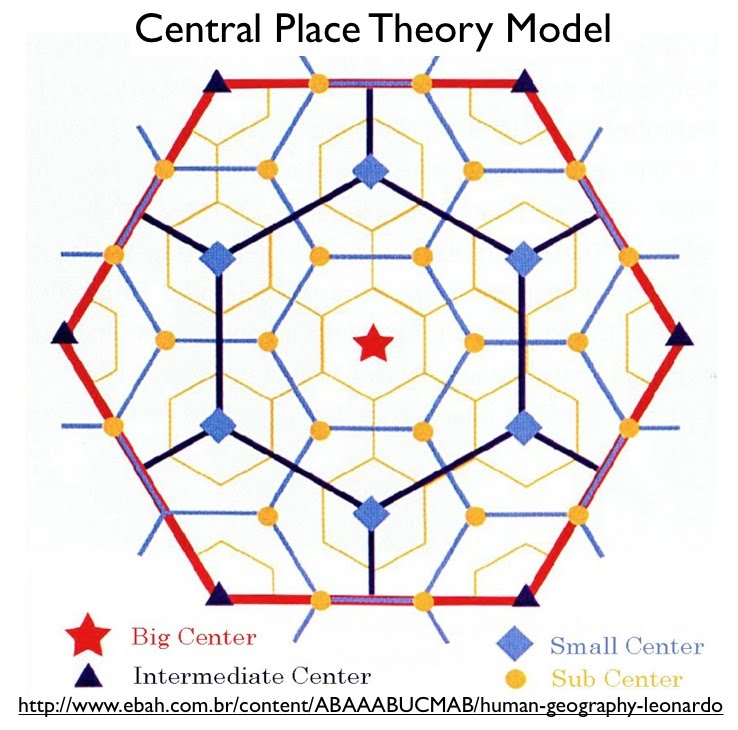
central place theory
Theory which explain the hierarchical patterns in the number, size, and location of cities and other settlements.
describes a central place as a settlement that provides goods and services for the surrounding area
megacity
metropolitan area with a population of over 10 million people
metacity
metropolitan area with a population of over 20 million people
world cities
top of the world’s urban hierarchy
significant urban centers that have a substantial impact on global economic, cultural, and political affairs
rank size rule
the population of a country matches with its rank
1) most population
2) half of first
3) one third of first
etc
Annexation
Taking over land to use as own
Megapolis
the merging of the urbanized areas of two or more cities, usually through suburban growth and expansion
Greenbelt
ing of parkland, agricultural land, or other open space maintained around an urban area to limit sprawl
Sprawl + issues
The spread of dispersed urban land uses outside compact urban centers into previously rural areas.
more traffic
pollution
uses open space
expense of providing urban services
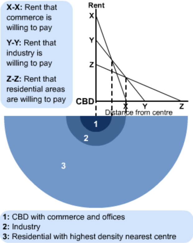
Bid-Rent Theory
Key terms: land value, commercial location, and transportation.
Land costs drop as distance from the CBD grows
Urban Hierarchy
Different cities have different functions within an urban hierarch
Order depends on what the area offers
City → town → village → hamlet
Central Business District
Main commercial area of a city, typically characterized by high land values, dense construction, and a concentration of businesses and services
land tenure
People living in informal housing lack land tenure, or legal rights associated with owning land.
Shack dwelers
abuse from land owners
can be kicked out
in some countries, women don’t have land tenure
challenges in core relating to housing
Redlining
rising labour and material costs
expensive homes near CBD so poor moves far from work- high home + transport costs
Urbanization in MDCs versus in LDCs (Who lives where?)
MDCs;
urbanization is mainly complete
Gentrification: renewing older areas so rich population takes over poor population by raising rent
wealthier people live in surburbs
LDCs:
Suburbanization is rapidly increasing
rural to urban, densly impact
both: shanty towns are a problem
Two types of urban areas
Urbanized area: pop of 50,000+
Urban cluster: pop of 2,500-49,999
Suburbs
less densely populated residential and commercial areas surrounding a city
urban renewal
term associated with U.S. movement of 1950s and 1960s when cities were given grants to rebuild downtown
The three policies displaced 1 million+ people, mostly lower-income and African American
1+2) The Housing Act of 1949 and Housing Act of 1954 established federal funding to cover a large part of the cost of demolishing aging neighborhoods and building new ones.
3) The Federal-Aid Highway Act of 1956 launched the building of the Interstate Highway System which crisscrosses the USA
most places that had urban renewal were lower income areas for blacks, leading to homelessness
Gentrification
High income young people take over inner city
For character of old buildings and central location
Low-income people driven out by high rents
Gentrification leads to homelessness
infill
redevelopment of old land that used to be used
EX: Building townhouses in a gap between two already-existing neighborhoods
qualitative data vs quantitative data
qualitative: word form
EX: interviews
qualitative: numbers
EX: statistics
Redlining
When the government takes a red marker and circles certain areas with “higher risks” because it is usually black + hispanic people- were not given loans as it was a risk
when a lending institution refuses to offer home loans on the basis of a neighborhood’s racial or ethnic makeup
Effects: denied colored people to create generational wealth through property- many remained in low income areas and may have to rent
Block busting
when real estate agents would spread misinformation to white property owners to sell their house in the fear that black people will live there. they would sell their house for “below market prices”
real estate agents would then sell houses for more to colored people
Disamenity Zone
high-poverty urban area in a disadvantaged location containing steep slopes, flood-prone ground, rail lines, landfills, poor infrastructure, crime, squatters, etc
due to lack of investment from priv and formal sector, lack of affordable housing, and de-industrialization
areas composed of shantytowns or other informal housing
deindustrialization
process by which a country or area reduces industrial activity, particularly in heavy industry and manufacturing→ leads to breakdown of the cbds
Inclusionary zoning
Inclusionary zoning is a strategy first developed in the 1970s to counter the effects of exclusionary and racially segregated zoning
Inclusionary zoning laws create affordable housing by offering incentives for developers to set aside a minimum percentage of new housing construction to be allocated for low-income renters or buyers.
Eminent Domain
Sometimes a government invokes a right to land tenure that overrides the rights of individual owners.
a government’s right to take privately owned property for public use
The rationale for eminent domain is that it allows the government to make decisions that benefit the population as a whole rather than deferring to the benefit of private landowners.
Mixed used development
single planned development designed to include multiple uses
EX: apartment right above grocery store to increase walkability
Transit Oriented development
the creation of dense, walkable, pedestrian-oriented, mixed-use communities centered around or located near a transit station
smart-growth policies
The aim is to create sustainable communities by placing development in convenient locations and designing it to be more efficient and environmentally responsible
Zoning (Traditional vs Mixed-use) + Impacts
Zoning is a tool of smart growth
government uses to dictate what types of areas are built where
1) Mixed-use zoning permits multiple land uses in the same space or structure.
EX: A building where the ground floor is a small storefront (commercial) and the upper floors are apartments (residential)
2) Traditional zoning creates separate zones based on land-use type or economic function.
EX: Areas where only houses or apartments are allowed. No commercial or industrial activity is permitted.
New Urbanism
reaction to sprawling, automobile-centered cities.
main goal: preserve nature and create a sense of place where people can interact with eachother
limits urban expansion while preserving nature and usable farmland
preserve historic buildings
infilling to create new urban spaces
slow growth cities
Slow-growth cities slow the pace of development to retain sense of place and preserve open space and decrease the outward growth of a city
filtering
housing vacated by more affluent groups passes down the income scale to lower-income groups
The process of buildings being divided into smaller units for lower-income housing
zone of abandonment
A zone of abandonment refers to an area within a city that has experienced significant decline, resulting in disinvestment, vacant buildings, and general neglect.
causes:
deindustrialization
Suburbanization
natural diasters
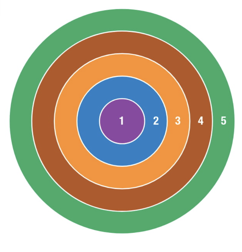
concentric zone model
The Burgess concentric-zone model visualizes cities developed in rings around a central business district, or CBD.
1) Central Business Theory: The CBD is the heart of the city — it's the economic and commercial hub where businesses, offices, shops, and entertainment are concentrated.
traffic congestion
high land value
2) Zone of Transition: This is a mix of residential and commercial use, transitioning from the central CBD to more stable residential areas. It's often characterized by social and economic changes as older industrial or commercial areas begin to be replaced by lower-income housing or mixed-use developments
Housing: low quality, high density, ethnic, sometimes renovated or gentrified
lots of people travel from suburbs to cbd via transition zone
3) Zone of independent worker’s home: This ring consists of more stable, lower-middle-class neighborhoods, where working-class families can afford to live while still being close to the city center. It’s often characterized by modest, single-family homes or apartments
Blue-collar residences
apartments
4) Zone of better residencies: This is a suburban ring where wealthier individuals and families live. These areas are typically more affluent with larger homes and access to more green space
better schools
richer shopping centers
5) Commuter Zone: The outermost ring of the city consists of suburbs or exurbs — more rural or residential areas where people typically commute into the city for work or leisure. This zone represents the areas that are farther from the city center, often where people can afford larger homes with more space
car dependent
largest homes
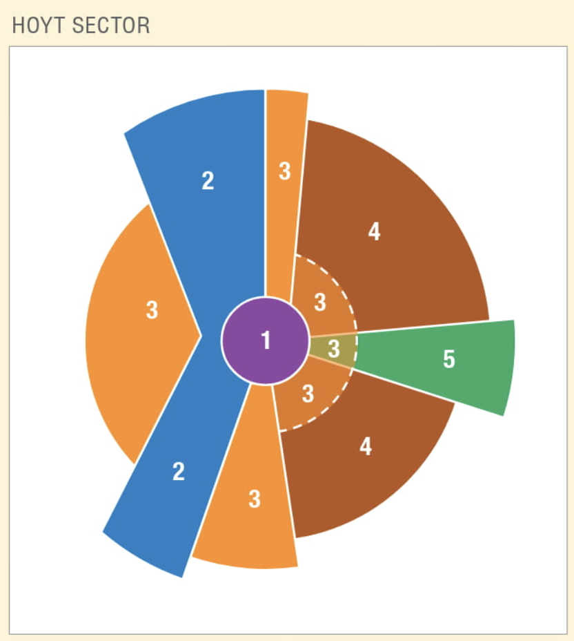
Sector model (hoyt)
The Hoyt sector model envisions cities developed around a CBD and heavily influenced by transportation routes.
Spread along rail lines or transportation
1) CBD (middle): the CBD is the center of economic and commercial activity
2) transportation and industry (blue) : heavy industry or manufacturing typically located along railroads, highways, or waterways for easy transport of goods
3) low class residential (orange): These neighborhoods tend to be located in areas where land is cheaper but still accessible to the CBD and its commercial activities.
single family homes
pollution
4) middle class residential (brown): farthest from industrial areas and closest to recreational areas, parks, or natural amenities
5) high class residential (green): farthest from industrial areas and closest to recreational areas, parks, or natural amenities.
high property values
larger homes
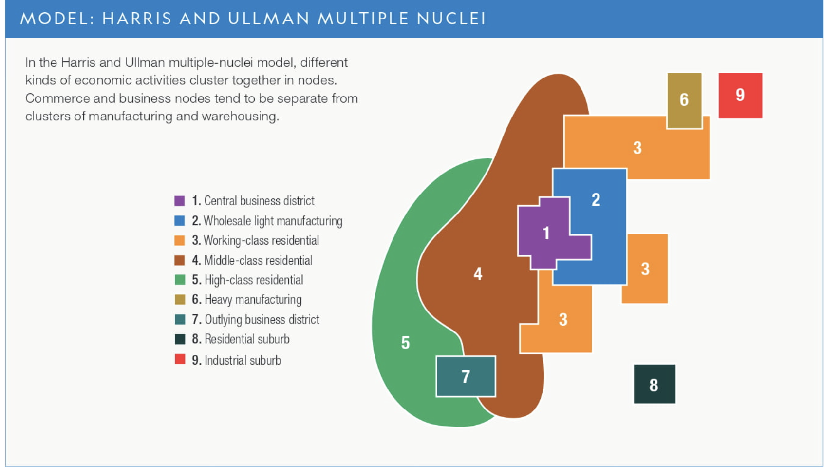
multiple nuclei model
In the Harris and Ullman multiple-nuclei model, different kinds of economic activities cluster together in nodes. Commerce and business nodes tend to be separate from clusters of manufacturing and warehousing.
model with multiple CBD’s- attracts certain activities and repels others
people will live near the node they work (EX: manufactures would live in their specific nodes and wealthy people wouldn’t)
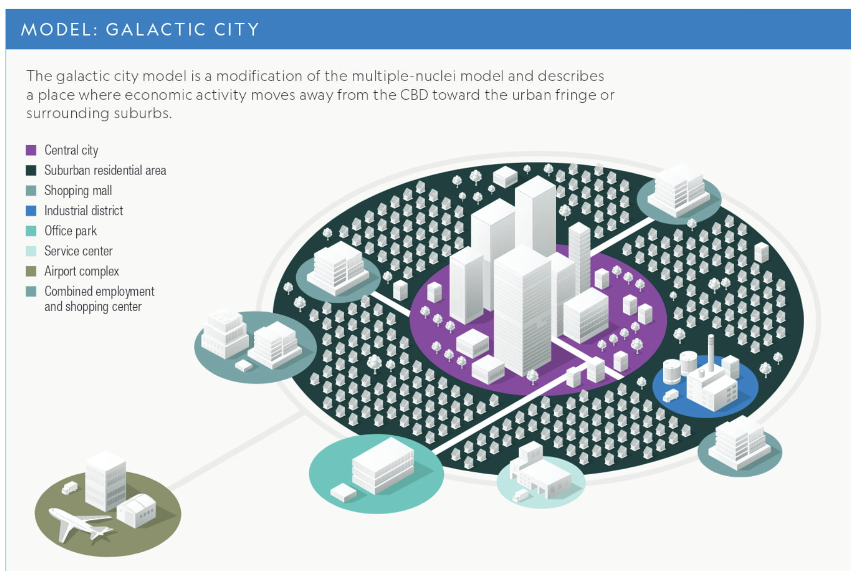
galactic model
The galactic city model is a modification of the multiple-nuclei model and describes a place where economic activity moves away from the CBD toward the urban fringe or surrounding suburbs
service based
acknowledges edge cities
Based on independent transportation
includes beltways
more specialization=less manufacturing
post industrial
Latin America city model
center: plaza that used to be ruled by another country and usually had religious aspects
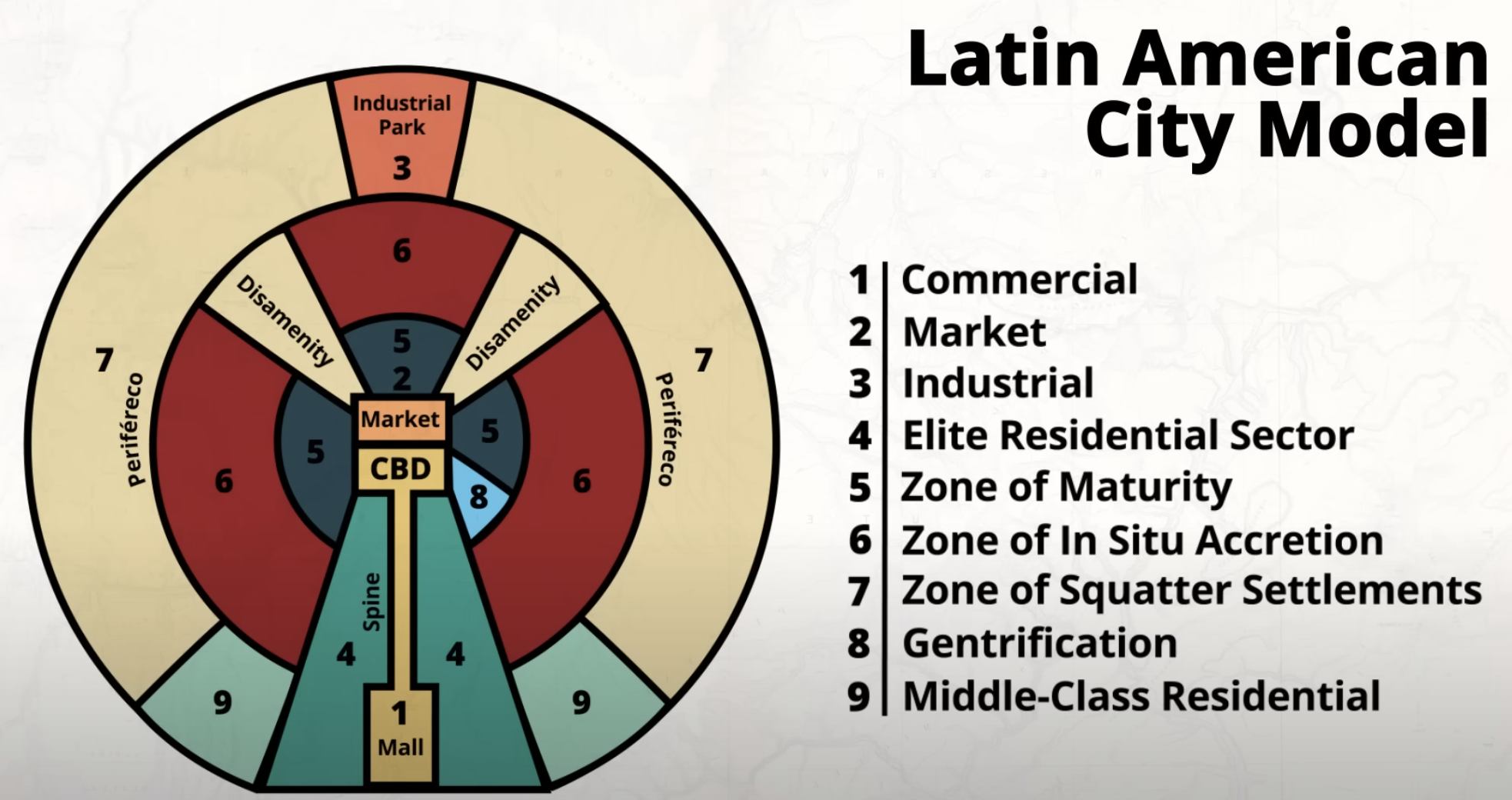
squatter settlements
Disamenity zones often include informal housing areas known as squatter settlements , which are beset with overcrowding and poverty
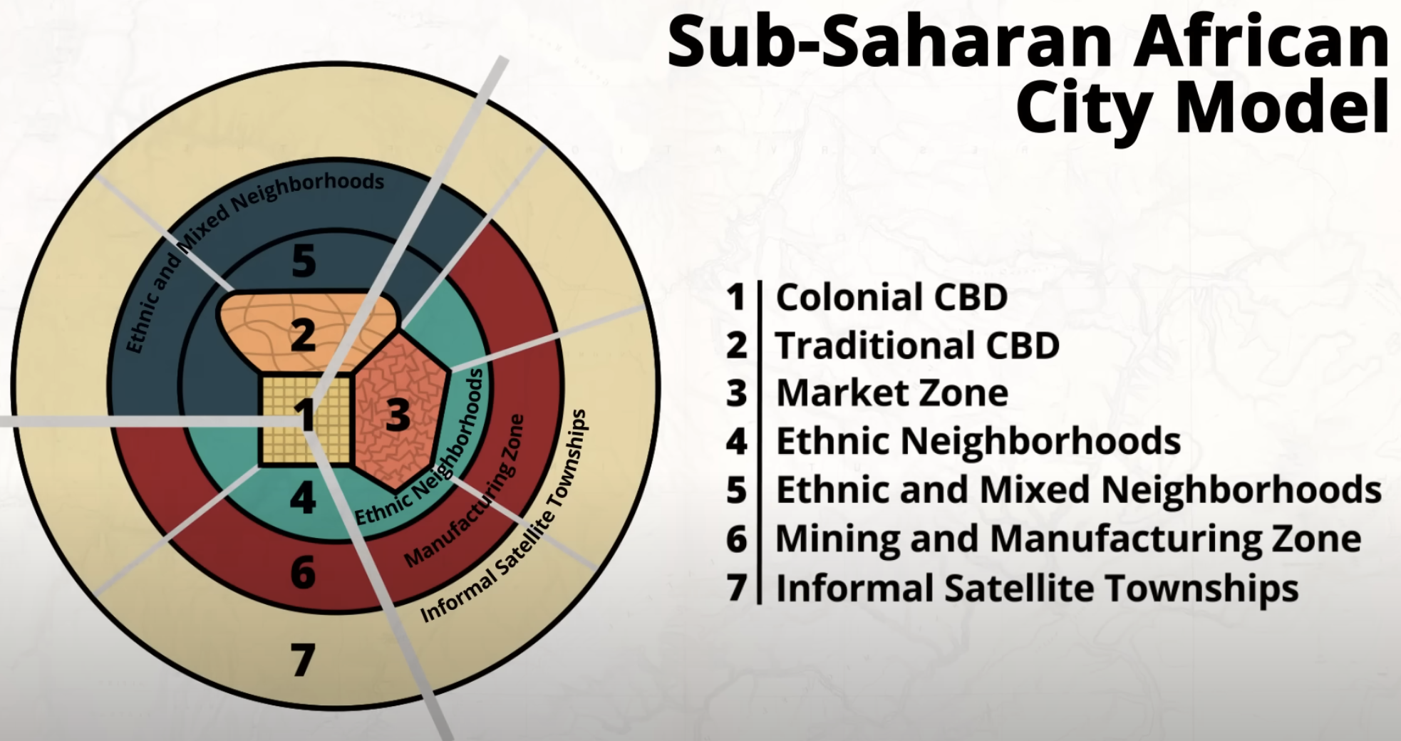
sub-saharan african city model
The neighborhoods in the African city model tend to be divided along ethnic lines, reflecting the great diversity found on much of the continent.
3 cbds
1) colonial=grid
2) traditional=informal shops
3) market zones=trading
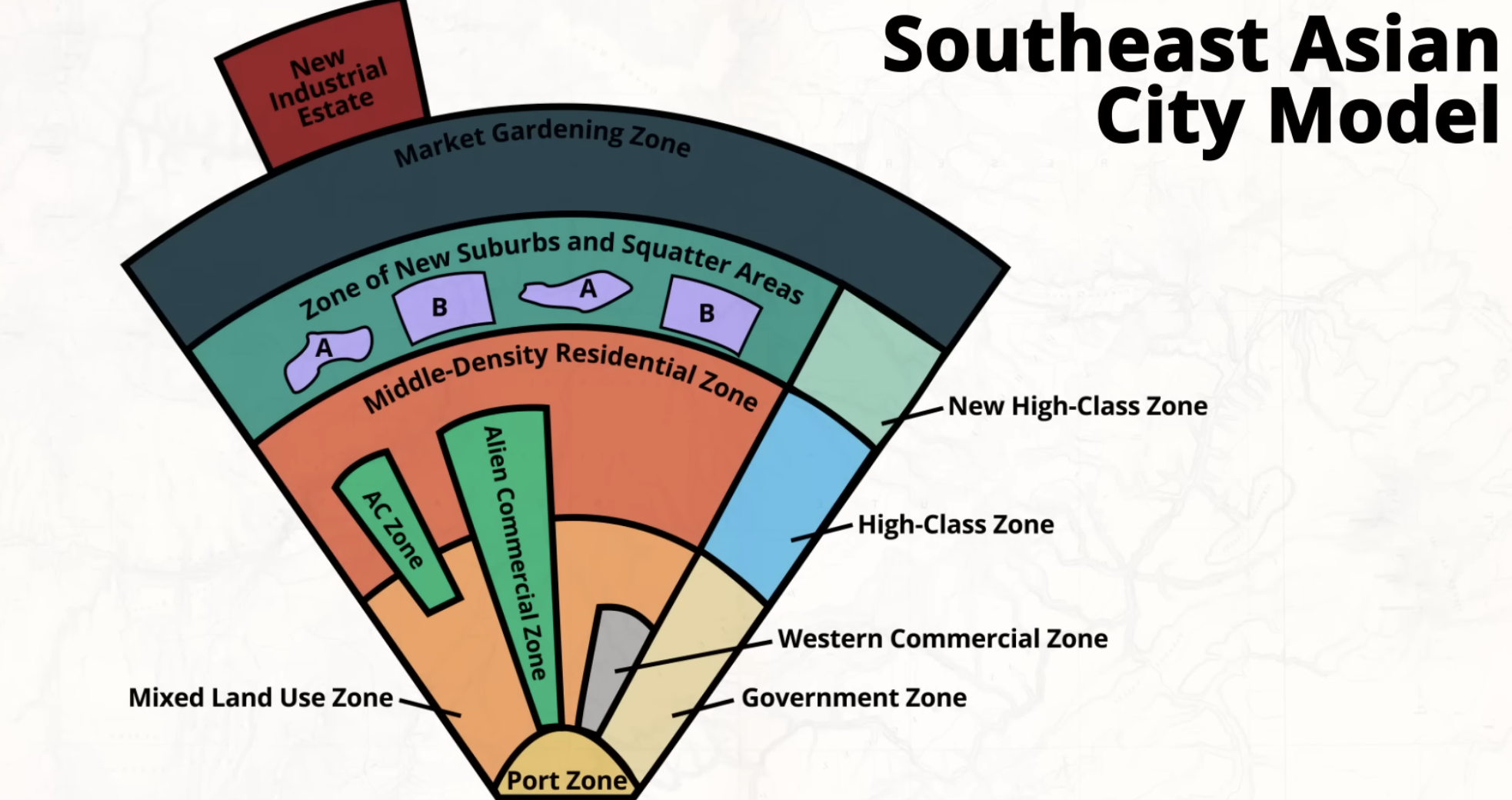
Southeast asian model
Many cities in Southeast Asia grew up around ports, which explains the cities’ relationship with imperialistic powers as well as the importance of trade.
no cbd, just a port- many developed as trading posts in colonial area
rapid urbanization- center of city should be near port to quickly transport items international
world cities
connected globally -drivers of globalization
hearths of contemporary culture
centers of innovation, trade, manufacturing, etc
public housing
Government-owned housing provided for low-income individuals or families who can't afford market-rate housing.
Often found in inner cities or areas with high population density.
market areas/hinterlands
the area of influence a city/town/village has- a larger area have larger market areas, however, they are fewer in numbers
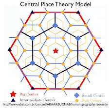
treshold vs range
treshold: minimum amount of people needed to support a business
range: maximum distance people are willing to travel to get a service
Leapfrog Development
developments that jump over established developments , leaving undeveloped or underdeveloped land between developments.
origins of urban place
access to resources and access to transportation
Types of Regions (Cultural, Formal, Functional, Vernacular)
cultural: based on languages, food; culture
formal: A geographic area that has common attributes traditionally defined by economic, political, social, or environmental characteristics
functional: A geographic area that is organized around centerpoint,or a node. Often tied to transportation,to communication,or an economic activity.
Vernacular: This is a region that only exists because people believe it exists. This region will change based on who you are. It is based on common Qualitative Characteristics (non-number)
counterurbanization
moving out of the inner city to rural areas to escape congestion, crime, pollution, etc
metropolitin statistical area
Is a city and the surrounding areas that are influenced economically and culturally by the city, including suburbs
A region in which a central city and surrounding areas are linked by social and economic ties
cultural region
A cultural region is defined by the shared cultural traits of the people in the area. These traits can include language, religion, traditions, or ethnicity.
EX: bible belt
vernacular region
A vernacular region is based on people's perceptions
EX: ideas of the midwest
formal region
A formal region is an area that is officially recognized and defined by specific, measurable criteria (such as political boundaries, climate, language, or economic activities
EX: country/state borders, climate borders
functional/nodal
Defined by a specific function or activity revolving around a node
EX: airport
types of smart growth policies
zoning
slow groth cities
transit oriented development
new urbanism
urban renewal connects to
gentrification
Governments use various means to attract businesses into cities
•tax breaks or financial incentives
•industrial parks or zones
•land-use plans and zoning ordinances
•transportation linkages or improvements
•safety and security
•policies that promote livability
exurbs, boomburbs,
exurbs=low density, rich neighborhoods: rural to semi-rural
boomburbs= population growth
edge city=commercial use