W6 - Fire (Bushfires)
1/24
There's no tags or description
Looks like no tags are added yet.
Name | Mastery | Learn | Test | Matching | Spaced |
|---|
No study sessions yet.
25 Terms

Key Concepts for Quiz 1
Covers content from Weeks 2–6.
Key areas:
Concepts: vulnerability, resilience, DRM.
Definitions and statements.
Graphics and models (e.g., DRM propeller).
Frameworks: UN, government approaches.
Knowledge: scientific vs Indigenous; top-down vs bottom-up.
Case studies: Philippines, Mekong Delta, drought in South Africa.
Hazards: droughts and bushfires – definitions, types, examples, impacts
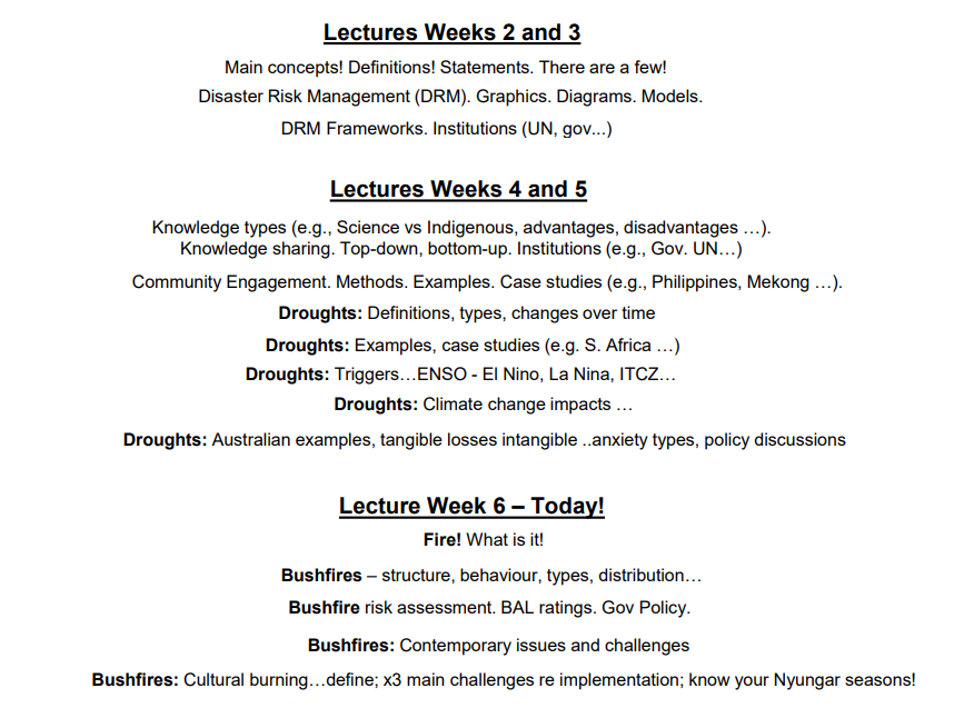
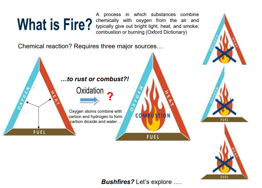
What is Fire
Defined as a chemical reaction where substances combine with oxygen, producing light, heat, and smoke (combustion/burning).
Requires fuel, heat, and oxygen (fire triangle).
Oxidation process: carbon and hydrogen combine with oxygen to form CO₂ and water.
Transcript: compared to rusting – same oxidation process but fire happens rapidly
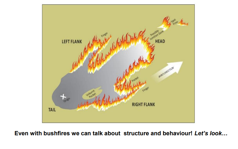
Parts of a Bushfire IMAGE
IMAGE
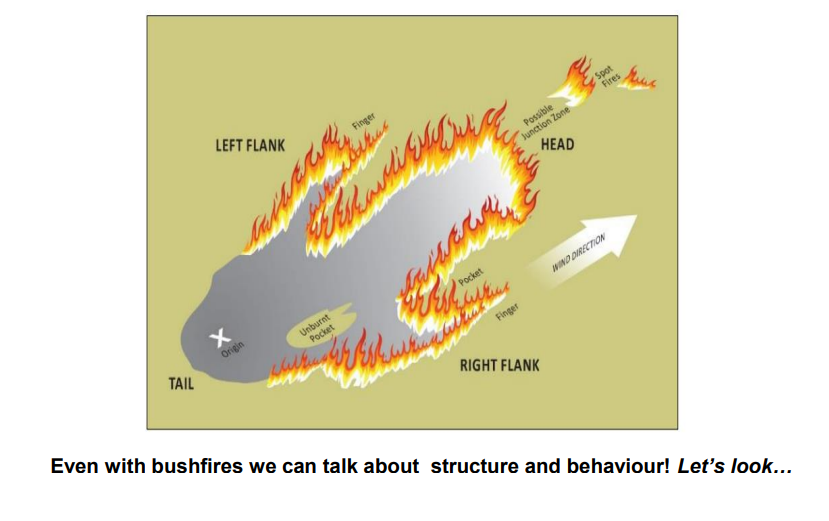

Bushfires - Structure and Behaviour
Basic anatomy: head, flanks, tail/origin, with spread influenced by wind.
Spot fires: embers can ignite new fires kilometres ahead.
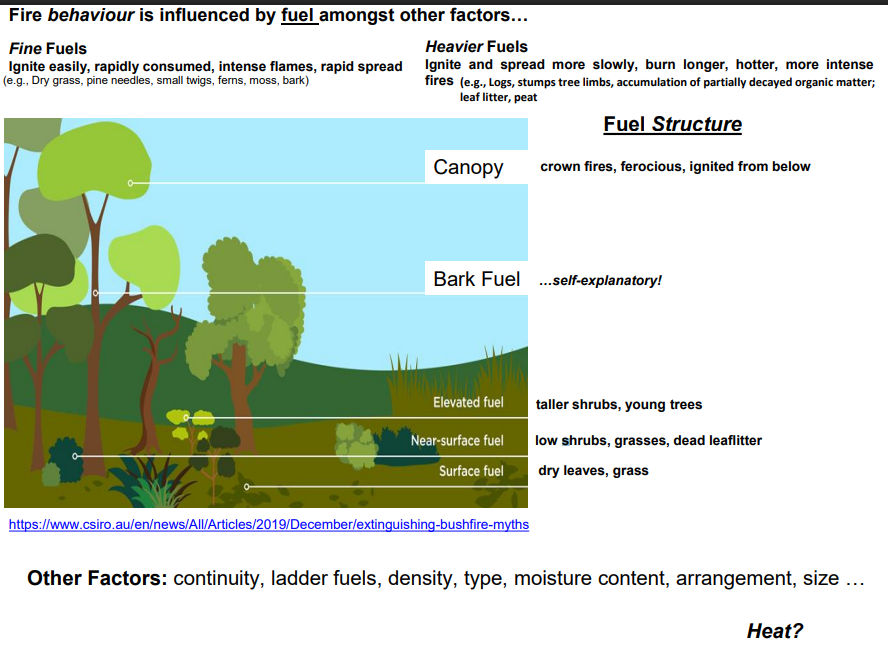
Fuel types:
Fine fuels: dry grass, pine needles, twigs → ignite easily, spread fast.
Heavy fuels: logs, stumps, accumulated organic matter → burn slower, longer, more intensely.
Fuel structure: surface fuels (leaves, grass), near-surface (shrubs), elevated fuels (young trees), canopy (crown fires).
Factors affecting fire: fuel continuity, ladder fuels, density, type, moisture content
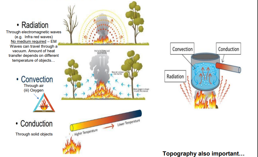
Heat Transfer
Radiation (infrared waves, no medium needed).
Convection (through air/oxygen).
Conduction (through solids).


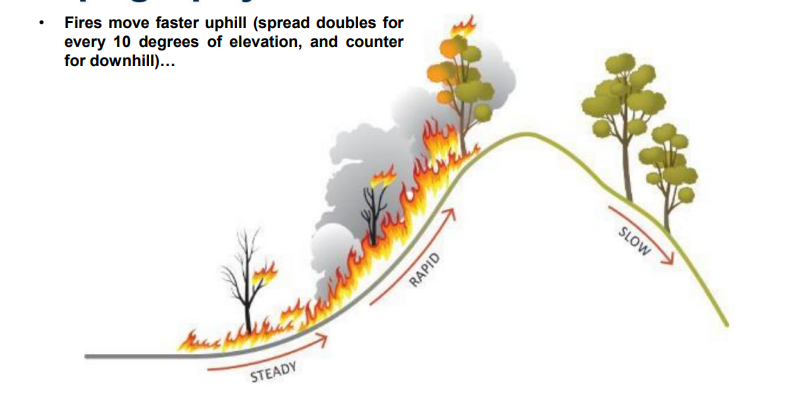
Topography
Fires move much faster uphill – spread doubles with every 10° slope.
Grassfires on slopes can reach 30 km/h; spot fires recorded 30 km away
travels faster uphill because the slope preheats fuels in front of the fire's path, and rising convective heat (hot air) concentrates more heat on the fuel ahead
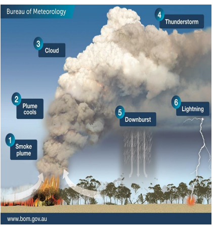
Pyrocumulonimbus
1. A plume of hot, turbulent air and smoke rises.
2. Turbulence mixes cooler air into the plume, causing it to broaden and cool as it rises.
3.. When the plume rises high enough, low atmospheric pressure causes its air to cool and cloud to form.
4. In an unstable atmosphere a thunderstorm can develop: pyrocumulonimbus cloud
5. Rain in the cloud evaporates and cools when it comes in to contact with dry air, producing a downburst.
6. Lightning may be produced and can ignite new fires

Weather and Bushfires
Weather conditions shape intensity, speed, and unpredictability.
Northern Australia → peak season in dry winter/spring.
Southern Australia → peak in summer/autumn.
Risk increases with hot, dry, windy, low-humidity conditions.
Pyrocumulonimbus clouds: fires create their own weather, producing thunderstorms, lightning, embers up to 30 km, and even fire tornadoes.
Transcript: Black Saturday and Canberra fires worsened by these phenomena

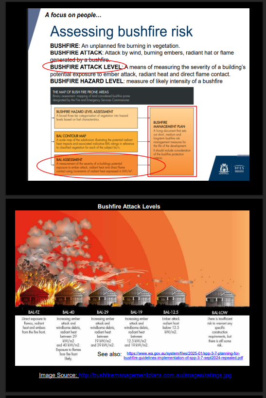
Assessing Bushfire Risk
Fire Danger Ratings: from low/moderate to catastrophic.
Bushfire Attack Level (BAL): measures heat exposure risk to homes (ember attack, radiant heat, flame contact).
Ranges from BAL-FZ (Fire Zone) to BAL-Low.
Integrated into State Planning Policy (SPP) 3.7 – Bushfire: WA land-use policy for bushfire-prone areas.
Transcript: BAL especially relevant in urban sprawl areas near bushland
SPP 3.7 Bushfires
State Planning Policy 3.7 Bushfire (SPP 3.7) is a Western Australian policy that guides land use and development in bushfire-prone areas, focusing on risk-based planning and design to protect life, property, and infrastructure. The latest version, operational from 18 November 2024, emphasizes incorporating bushfire considerations early in the planning process and includes a broader landscape assessment to avoid development in high-risk areas. The policy is implemented through the Planning for Bushfire Guidelines, which provides detailed guidance for planning stages and requires the use of accredited practitioners for Bushfire Attack Level (BAL) assessments and Bushfire Planning and Design (BPAD) advice

Bushfires in the Australian Landscape - Physical and Climatic Factors
IMAGE
Bushfires are often described in relation to the primary fuel source burning: Four major types of (bush) fires: Forest Fire (tropical, temperate … rainforests) Woodland Fire (tropical, subtropical, temperate…Eucalypt) Shrubland Fire (Chenopod, hardy low shrub species)
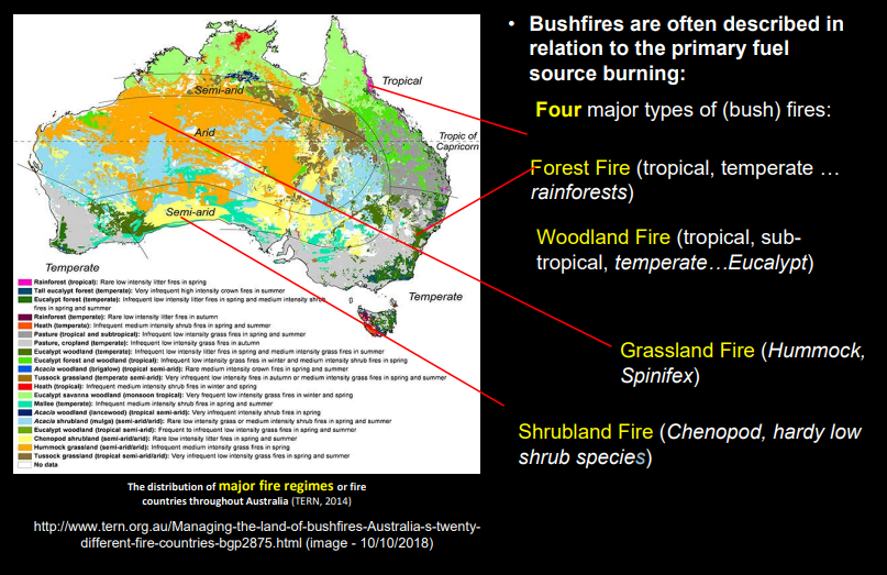
Bushfires in the Australian Landscape Summarised
Bushfires linked to fuel source and vegetation.
Four main fire types:
Forest fires – tropical/temperate rainforests.
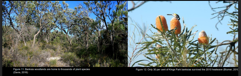
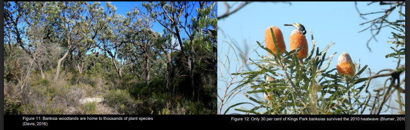
Woodland fires – common in eucalypt areas (e.g., Banksia woodlands).
Shrubland fires – mallee shrublands, southern Australia.
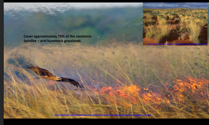
Grassland fires – dominant in central and northern Australia, Spinifex
Transcript: highlights biodiversity differences and challenges of varied landscapes.
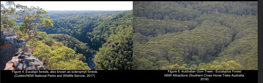
Forest Fires
tropical/temperate rainforests.
.'
Rainforest are either tropical (moist and warm/Queensland) or temperate (cool in winter, warm in summer/Victoria and Tasmania) 22% Australia is covered in forest and 78% Eucalypt Range from 5-30metres tall Fuel Strata: Surface fuel, dead leaves, bark and twigs Near surface fuel, grasses, low shrubs, creepers and collapsed understorey Elevated fuel, shrubs, regeneration of overstorey trees Canopy, crowns of the tallest trees (closed or open)

Woodlands Fires
common in eucalypt areas (e.g., Banksia woodlands).
.
Tropical and Temperate Low (less than 5metres) and tall (no more than 30metres) Topical and sub-tropical woodlands (Kimberley and far north Queensland) Winter significant grass growth that dries in summer mand becomes flammable Temperate (west of Great Dividing range, and western Victoria) Human impacts, agriculture, fires have become more infrequent and more intense

Shrubland Fires
mallee shrublands, southern Australia.
.
Found in southern parts of the continent Include eucalypt, acacia and shrub steppe Less than 8metres tall Fire threat is determined by scattered clumps of shrubland Above average rainfall promotes growth of grasses and can increase fire risk
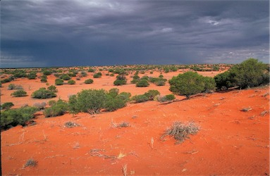

Grasslands Fire
dominant in central and northern Australia, Spinifex
.
Human Factors
Ignition sources: deliberate, accidental, lightning.
Land-use planning: settlements expanding into bushfire-prone areas.
Exposure: people, property, infrastructure.
Response capacity: emergency services.
Cultural perspectives:
Indigenous Australians – used fire for millennia (fire-stick farming, cultural burning).
Europeans – tended to “fight” fire, viewing it as an enemy.
Historical examples: Black Thursday (1851), Ash Wednesday (1983), Black Saturday (2009)
Contemporary Issues and Challenges
Urban sprawl: Perth’s northern corridor expansion into bushfire-prone areas.
Tourism/farm stays: risks if planning doesn’t account for fire breaks and safety.
Climate change: hotter summers, more frequent and intense fires.
Need for improved planning and resilience strategies

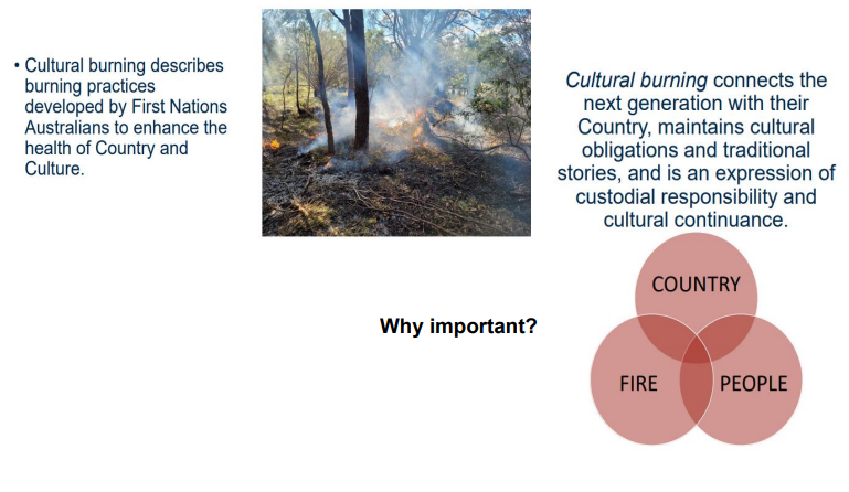
Cultural Burning
Indigenous practice of using cool, small, controlled fires to manage country.
Benefits:
Reduces risk of severe bushfires.
Supports biodiversity and land health.
Connects people and culture to country.
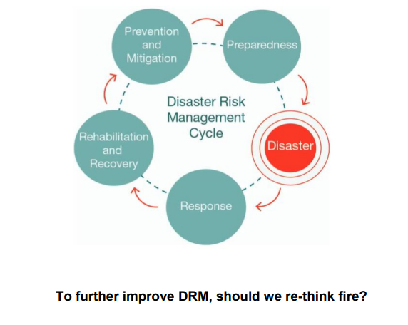
Transcript: contrasts Indigenous long-term adaptive practices with European approaches, raising the question: “Should we rethink fire?”
Vulnerability, Resilience, Differentials
IMAGE

Uses of Fire
WHY DID ABORIGINAL PEOPLE USE FIRE:
Practical
Spiritual
Ecological (Environmental)
This is how aboriginal people care for country
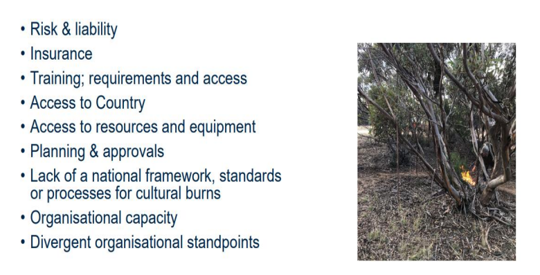
Challenges
IMAGE

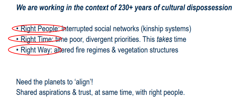
Key Challenge 1: The right people/time/way isn’t always straightforward

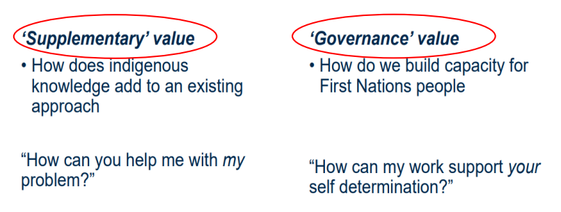
Key Challenge 2: How are our motivations interpreted?
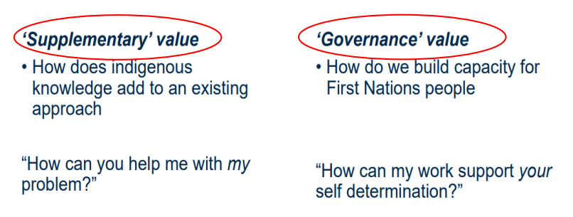
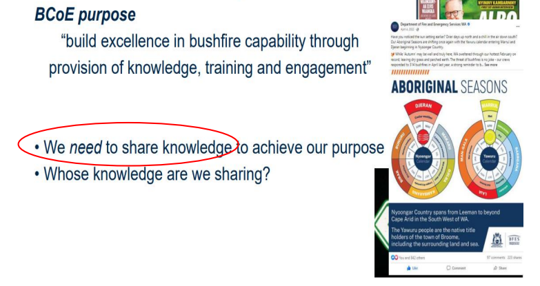
Key Challenge 3: Respecting First Nations knowledge and IP
IMAGE
