CONTINENTAL DRIFT PALEOMAG
1/53
There's no tags or description
Looks like no tags are added yet.
Name | Mastery | Learn | Test | Matching | Spaced | Call with Kai |
|---|
No study sessions yet.
54 Terms
Bathymetry
•Shape or topography of the ocean floor
•Measurements of the vertical distance between sea surface and the bottom of the ocean.
•Soundings are used to collect this information, by rope, echo (ping) and sonar, satellite
Marine Provinces: 3 Major Types
Continental margins
–Shallow-water areas close to shore
Deep-ocean basins
–Deep-water areas farther from land (Much deeper and flatter)
Mid-ocean ridge
–Submarine mountain range (elevated submarine mountain range that runs along divergent plate boundaries) (SAME AS SPREADING CENTER THAT MAKES MORB)
Continental Margins
Passive
–Not close to any plate boundary
–No major tectonic activity
–Example: east coast of the United States
Active
–Associated with convergent or transform plate boundaries
–Much tectonic activity
A continental margin is the zone where a continent meets the ocean, made of the continental shelf, slope, and rise.
Continental shelf A wide, shallow stretch of seafloor just off the shore where the water is relatively shallow and waves and rivers drop most of their sand and mud.
Continental slope The steeper drop that starts where the shelf ends and the seafloor falls away toward the deep ocean.
Continental rise A gentler slope below the steep part where sediments collect into a thick, sloping pile before the abyssal plain begins
Deep-Ocean Basins
Broad, relatively flat low-lying regions between continental margins and mid-ocean ridges. (Much deeper; includes abyssal plains, trenches at basin margins, and seamounts.)
Abyssal Plains:
Trenches at Basin Margins:
Seamounts:
A deep-ocean basin is an old part of the seafloor that has cooled and sunk, slowly covered by layers of sediment carried and sorted by ocean currents, and that layers act like a long-term storage of materials and a written record of Earth’s ocean history
Record the history of oceanic crust aging, sedimentation, and oceanographic circulation and host major reservoirs for sediments and marine resources.
-Ocean crust ages like a timeline. New crust forms at ridges and moves outward; the farther it travels the older it becomes.
-Sedimentation is a slow blanket. Tiny bits of shells, dust, and mud fall through the water and pile up on the old seafloor, layer by layer.
-Water movement shapes where things end up. Currents carry sediments and nutrients across the basin and decide where sediments collect and where life concentrates.
-Basins store resources and records. Those thick sediment layers hold buried materials such as minerals and organic remains and preserve a history of past climates and ocean life
Oceanic crust created at ridges moves outward, cools, sinks, and accumulates sediment over time; older crust lies farther from ridges and forms the flat, sediment-covered basins. Trenches form where oceanic crust is pushed back into the mantle at convergent boundaries.
Mid-Ridge
Textbook: A divergent boundary within an oceanic plate, where new lithosphere and crust is created as the two plates spread apart. Mid-ocean ridge and spreading center are synonyms
Site of active magma upwelling and seafloor spreading where new oceanic crust is formed from rising basaltic magma.
-Linear, elevated submarine mountain range that runs along divergent plate boundaries.
-little to no sediment on the ridge crest because the crust is young and continuously renewed; crust is very young at the spreading center.
-Active plate-boundary features that generate new crust and drive plate motions.
Mantle rock rises beneath divergent plate boundaries, melts, and produces basaltic magma that solidifies as it cools, pushing older crust outward and creating a ridge with a central rift valley. New crust at the ridge is very young and barely has any sediment on it.
Marine Provinces (Photo)
Vertical Exaggeration: A visual trick used in maps, profiles, or cross-sections that makes height or depth look larger than it really is.
It stretches the vertical scale compared to the horizontal scale so small hills or deep valleys are easier to see.
It does not change real distances; it only makes up–down features look more dramatic.
Ocean Trench: Moving down to be recycled.

Abyssal Plains
Abyssal plains are very flat, wide areas of the deep ocean floor covered by a thick blanket of mud and tiny shell fragments
They form where fine sediments slowly fall and spread out over old, quiet seafloor until the bottom becomes smooth.
They lie far from shore and are among the deepest, flattest places on Earth.
Abyssal plains form far out on the deep ocean floor, usually between the continental margins and the mid-ocean ridges where the seafloor is old and quiet.
Trench
A deep and narrow valley on the ocean floor where one piece of the Earth’s crust bends down and dives under another. Happens when two tectonic plates move toward each other (the oceanic is the thinner)
From Deep-Ocean Basin
Ridge
A ridge is a long, raised underwater mountain chain where tectonic plates pull apart and new oceanic crust is formed.
From Deep-Ocean Basin
How Continental Margins Form
A continental margin is the ocean edge of a continent made of three parts: shelf (shallow nearshore), slope (steeper drop), and rise (gentle buildup before the deep sea).
They form because the continent’s thick rock extends under the nearby sea and because material from land keeps washing out onto that edge.
Rivers, waves, and glaciers carry sand, mud, and broken shells off the land and drop them on the shelf; over long time those bits pile up, slide down the slope, and build the rise.
Plate tectonics changes the margin type:
Passive margin: no nearby plate boundary, so sediments quietly pile up and the shelf is wide and calm.
Active margin: near a plate boundary, so the edge is steep, earthquake-prone, and may have trenches or volcanoes.
Oceanic Vs Continental Crust
Continental crust is thicker than oceanic crust.
Plate Tectonics: A Unifying Theory Of Geology
•The Earth’s surface is separated into huge plates of lithosphere (crust + upper upper (or uppermost) mantle) that float or slide on the underlying asthenospheric mantle
•Tectonics is the study of the movement and deformation of these plates
•All the major topographic features on Earth’s surface arise as a direct result of the motion and interactions of lithospheric plates
•Plate tectonics explains the global distribution of
→Volcanoes, Earthquakes, Faults, Mountain belts, Features of seafloor
•Evolution of continents and oceans
Can Plates Explain Climate Change?
No, it just features solid Earth over long periods of time.
Asthenosphere (Short Definition in Class)
(plastic) Under Lithosphere
Plate Tectonics
•The theory of plate tectonics has emerged over centuries of contributions from many scientists including DaVinci, Hutton, Darwin and Wegener
•In 1508 Leonardo DaVinci discovered fossil seashells (it’s usually formed in oceans, so they must of been transported somehow) high in the Italian mountains and reasoned that part of the seafloor must have been uplifted
•In the late 1700s James Hutton realized that such uplift would expose rocks to weathering and erosion
•In 1835 Charles Darwin experienced a great Chilean earthquake that brought mussel shells 10 feet above the high water mark
Alfred Wegener
•Attempted to match shorelines of continents like puzzle pieces.
•Noted similarities among different continents
Plate Tectonics (Wegener)
•In 1914 Alfred Wegener published his Continental Drift hypothesis, which tried to explain the parallel shapes of the Atlantic coastlines, matching glacial landscapes (glaciation marks left on land), mountain ranges, and plant and animal fossils on continents separated by ocean basins
•He suggested that these landmasses were together in a single supercontinent “Pangea”
•Wegener presented his observations to support that the continents of today slowly drifted away from each other after having been disrupted and broken apart
•However, Wegener could provide no mechanism to explain how the continents moved, and when he died in 1930 there were few supporters of his hypothesis
Evidence for Continental Drift
Puzzle-like fit of continents
Edward Bullard fit continents at 2000 m water depth (Used that depth because that marks the true edge of continental crust and gives a much cleaner fit than the modern shoreline)
Matching sequences of rocks and mountain chains
–Similar age, rock types, structures
Glacial ages and other climate evidence
–Ancient glaciation in modern tropical regions (Finding ancient glacier marks in today’s tropics tells us continents moved from cold to warm places, supporting continental drift.)
–Direction of glacial flow
Distribution of organisms
–Same land animals distributed in different continents (e.g., South America and Africa)
Other “Explanations” to “Disprove” Continental Drifting
Rafting: Fossils ended up in different places because of rafting. It can happen but not to this scale.
-Transporting by carrying away from land by riding on a floating carrier.
Isthmian Links: narrow land connections or little land bridges
Island Steeping Stones
What was the Problem Behind the Continental Drift Theory?
It had no mechanism to explain it.
Objections to Continental Drift
•Continents cannot “plow” through ocean crust (it’s impossible for a continent to push straight across and crush through the ocean floor like a ship plowing through water.)
•Gravitational forces associated with tides is too small
Earth’s Physical (MECHANICAL Structure)
Think of a boiled egg.
A “plastic” lower layer
A rigid, brittle outer shell
Cracked Shell: Tectonic plates (Lithosphere- flakes and moves around)
-Brittle shell, breaks under pressure/force. Solid if you press, it will move/sink
(White): aesthenosphere. Solid but fluid but NOT a liquid. Capable of moving (can squish it)
Outside pressure: low
Inside Pressure: High (surrounded by rock); Lithostatic pressure
-Right now, is low pressure due to atmospheric pressure,
Is the Mantle a liquid?
The Mantle is NOT a liquid. It is a solid and green.
Asthenosphere
The asthenosphere is a solid part of the upper mantle that behaves like a very slow-moving, deformable solid rather than a true liquid.
It is soft enough to flow slowly over long timescales, allowing tectonic plates to move above it because parts of it can bend and creep under pressure.
Internal Structure of the Earth (Simple)
Mesosphere: “Middle Sphere” within the mantle.
Asthenosphere: “Weak Sphere” in the upper mantle.
Lithosphere: “Rocky Sphere” The outermost 100km
Internal Structure of the Earth (More Informed)
Lithosphere (sphere of rock)
•Consists of the crust and uppermost mantle (“upper upper mantle”)
•Averages about 100 km in thickness.
•Thickness of 80 km under oceans
•Thickness of 250 km or more beneath the older portions of the continents
Asthenosphere (weak “plastic” sphere)
•Beneath the lithosphere, in the upper mantle to a depth of about 660 km (D’’)
•Small amount of melting in the upper portion mechanically detaches the lithosphere from the layer below allowing the lithosphere to move independently of the asthenosphere (due to convection and heat; the asthenosphere moves REALLY SLOW)
Mesosphere or lower mantle
•Rigid layer between the depths of 660 km and 2900 km
•Rocks are very hot and capable of very gradual flow
Under different conditions- materials will behave differently
Think the lithosphere as a boat, more weight on top, and it will sink but if you remove it, then it will float (eventually bounces back up gradually but at a very slow pace)
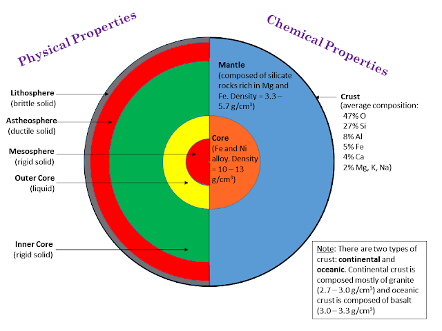
Earth’s Compositional Structure (3 Parts)
Crust: The comparatively thin outer skin that ranges from 5 – 10 km at the oceanic ridges and 35 – 100 km in some mountain belts
Mantle: A solid rocky (silica-rich) shell that extends to a depth of about 2900 km
Core: An iron-rich sphere having a radius of 3486 km
Earth’s Compositional Structure (2)
Outer Core:
•Composed mostly of an iron-nickel alloy
•Liquid layer
•2270 km (1410 miles) thick
•Convective flow within generates Earth’s magnetic field
Inner Core:
•Sphere with a radius of 3486 km (2164 miles)
•Stronger than the outer core
•Behaves like a solid
Earth’s Magnetic Field
The Earth’s magnetic field protects the Earth’s surface from harmful ionized particles from space (protects us from radiation)
Magnetic equator shown as red line (the line around Earth where the planet’s magnetic field is horizontal and the magnetic inclination (dip) is zero. It is defined by the shape of Earth’s magnetic field and slowly shifts over time as the field changes.)
Geographic equator is normal to earth’s rotation axis and is shown in black (The geographic equator is the imaginary line around Earth halfway between the North and South Geographic Poles. Defined by the direction of Earth’s rotation)
Note magnetic lines converge at poles
Magnetism flips and we see that in rock measurements
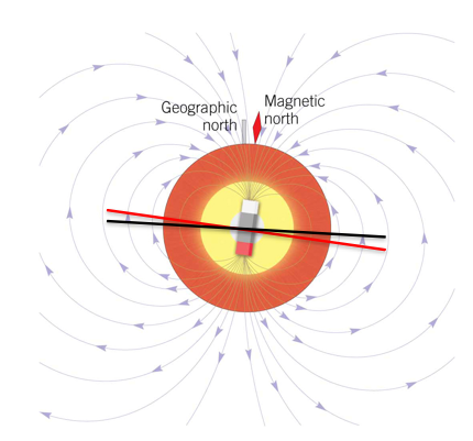
Plate Tectonics (Magnetism)
In the 1950s, scientists started using volcanic rocks to measure the past polarity of Earth’s magnetic field
Geophysicists found evidence that suggested the Earth’s poles wandered all over the globe - and that the apparent wandering for Europe and North America took different paths
Earth’s magnet field resembles a bar magnet.
Magnetosphere
•The earth’s magnetism is the result of the magnetic dynamo existing in the core.
•Convecting liquid iron creates a magnetic field in a manner analogous to the action of a magnetic coil.
The Earth’s magnetic field is produced by moving, electrically conducting liquid in the outer core that acts like a giant self‑sustaining generator.
Flowing, spinning liquid iron in the outer core makes electric currents that behave like giant coils and create Earth’s magnetic field.
Hot, molten iron in the outer core rises, cools, and sinks, creating slow convective currents.
Earth’s rotation twists those moving metal currents into organized, spiral patterns.
Moving conductive fluid across an existing magnetic field generates electric currents.
Those electric currents reinforce and sustain the magnetic field, so the motion keeps the field going.
Geodynamo
The outer core is rapidly convecting due to heat escaping from the core to the mantle
A "stray" magnetic field (from the Sun) interacts with the moving iron in the core to produce an electric current that is moving about the Earth's spin axis, yielding a magnetic field—a dynamo!
-Convection in the outer core generates the Earth’s magnetic field
Earth’s magnetic field is created by the motion of electrically conducting liquid iron in the outer core; that moving metal acts like a giant, self‑sustaining electric generator called the geodynamo
Heat from the deep Earth makes the hot liquid iron in the outer core rise and cooler liquid sink, so the liquid moves in slow, rolling currents.
The planet’s spin stretches and twists those currents, turning messy flow into organized loops around the spin axis.
Any moving conductor in a magnetic field makes electric currents; the moving iron produces currents that create their own magnetic field.
Those magnetic fields feed back on the flow so the process sustains itself — the flows make the field and the field helps keep the flows organized. That self‑reinforcing system is the dynamo
Magnetic North
Converging lines at poles tends to cause compass needle to dip.
North component of compass needle - swing and vertical component - magnetic inclination.
(The compass needle’s horizontal part points toward magnetic north and can rotate left or right across the horizon; that horizontal aim is called the needle’s swing
The compass needle’s vertical part tilts up or down relative to the ground; that tilt angle is called magnetic inclination or magnetic dip and measures how much the field points into or out of Earth)
Higher latitude would angle more to the magnetic pole.
Rock Cores
Core taken using diamond drill provides information on direction toward magnetic north pole and the inclination toward the pole.
A diamond‑drilled core preserves the rock’s frozen compass direction and tilt, allowing scientists to read where and at what latitude the rock formed
Rocks record the magnetic north pole at the time of crystallization or deposition
(deposition = sediments settling and locking in the magnetic direction that existed when they were laid down.) (Rocks can preserve a snapshot of the direction of Earth’s magnetic field from the moment they formed. the magnetic minerals inside a rock locked in the direction of magnetic north that existed when the rock either formed by cooling or when its particles were laid down.
-Crystallization is what happens when molten rock (magma or lava) cools and solid minerals grow out of the melt.
-Deposition is when loose particles (sand, mud, tiny mineral grains) settle out of water or air and build up a layer of sediment.
Magnetic grains in that sediment can rotate and align with the ambient magnetic field while they’re settling or before they’re buried and compacted; once buried, their orientation becomes fixed.
Simple image: picture dust settling on a table and each grain pointing like a tiny compass while it lands, then getting cemented in place.)
As those magnetic minerals form and the temperature drops below their Curie temperature, their tiny magnetic directions line up with Earth’s magnetic field and become fixed.
Simple image: imagine tiny compass needles frozen into the rock as it cools.
When magnetic dip was used to determine position of the pole it appeared that the pole was “wandering” (When scientists used the angle of the magnetic field recorded in rocks (magnetic dip) to calculate where the magnetic pole should have been, the calculated pole positions from rocks of different ages did not line up — they seemed to move or “wander” over time)
-Movement that continents them; supports the idea of the continents moving.
OBSERVATION: Does not explain why the continents move.
Polar Wander Paths
From apparent polar wandering, scientists had to conclude that the continents had moved, carrying magnetized rocks with them, rather than the magnetic poles having moved
Seafloor Spreading
•Though apparent polar wandering revived the continental drift hypothesis, a mechanism explaining the movement was still lacking.
•But it wasn’t until 1959 when geologist Harry Hess was examining the oceanic ridges, and hypothesized that the topography could be explained by the ocean crust moving laterally, splitting along the oceanic ridges: seafloor spreading (moving apart with new material replacing it)
However, Marie Tharp said it first (But he was credited)
Plate Tectonics Paleomagnetism
•The study of paleomagnetism revealed an extraordinary phenomenon: records of magnetic reversals
•One consequence of the splitting and spreading of the oceanic crust is that older crust is farther from the ridge, and new lava filling the gap along the ridge becomes magnetized with the polarity of the Earth’s magnetic field
•Paleomagnetic bands form sequentially.
•They provide a means for relative age dating.
Pattern on floor; symmetry of magnetism and reversal (magnetic north and south). Symmetric about the ridge submit.
Magnet Time Scale
a timeline of Earth’s magnetic polarity reversals recorded in rocks. When Earth’s magnetic field flips (north and south swap), that change is locked into cooling lava and into sedimentary particles, so layers of rock record a sequence of normal and reversed polarity that scientists line up to make a calendar of magnetic history
The magnetic time scale is a dated sequence of Earth’s magnetic reversals recorded in rocks and used as a global clock for geological events
Curie Temp
A general number to apply to anything magnetic when it solidifies. Like a timestamp.
The Curie temperature is the temperature at which a magnetic material loses its permanent magnetism and becomes only weakly magnetic.
Below the Curie temperature the material’s atomic magnetic moments line up and the material is ferromagnetic, so it can hold a permanent magnetisation.
Above the Curie temperature thermal motion disrupts that alignment and the material becomes paramagnetic, so it no longer keeps a permanent magnetic direction
A lava flow cools and crosses the Curie temperature at time X. The minerals lock in “normal” polarity. Later, lab dating shows the rock formed 780,000 years ago, so the recorded magnetic state gives a timestamp that links that layer to the known polarity at 780,000 years.
Polar Wander
Chrons (during a chron the magnetic north and south stay in the same orientation; when the field flips, a new chron begin) can exhibit normal or reverse polarity
Small flips in polarity are called subchrons
Magnetic record is a method of relative age dating.
Earth’s Magnetic Field
•It was first thought that the Earth's magnetic field was caused by a large, permanently magnetized material deep in the Earth's interior
•In 1900, Pierre Curie recognized that permanent magnetism is lost from magnetizable materials at temperatures from 500 ºC to 700 ºC (Curie point or Curie temperature) (Lost at a high temp)
Curie Temp (PowerPoint)
•Magnetite crystallizes from ocean floor magma
•High temperature magnetite is non-magnetic
Low temperature magnetite is magnetic
To figure out why the ocean floor is stripped/ why it flips.
Normal Polarity
Seafloor moving apart and eruption
-melting occurs from decompression
Magnetism About The Ridge
Magnetism is symmetrical about the ridge.
Polarity Reversal in mid-ocean Ridge Basalt (MORB)
•Topography at mid-ocean ridge: Pull-apart zone creates a linear depression
•Stripes denote a polarity change
More Info on Ridges
Core samples show that the thickness of sediments increase with distance from the ridge crest
Drilling ship collects core samples of seafloor sediments and basaltic crust.
The Relationship between the Age and Depth of the Sea Floor
The relationship between the age and depth of the sea floor is fundamentally a function of temperature.
In other words, depth is a proxy for temperature.
Seismology tells you density
-The less dense= seismic waves slow down; faster is more dense.
Hot is less dense
Older is cooled down; denser sinks down.
Evidence of Seafloor spreading
•Parallel magnetic anomalies record changes in Earth’s magnetic polarity as sea floor created
•Age of ocean floor increases away from crest of mid-ocean ridge
Continents move apart because of formation of lithosphere.
On the map
Plates moving apart faster even though its big because it’s on an active subduction zone to pull it faster. Less steep, so it doesn’t have time to accumulate.
-East Pacific Rise
Oldest in Pacific crust is being recycled.
Physical and Chemical Portions of Earth
Reasoning for Magnetism Flipping
Earth’s magnetic field is generated by moving liquid iron in the outer core acting like a giant self‑powered dynamo.
The flow of that liquid creates electric currents which produce the magnetic field and keep it oriented roughly north–south.
The flow is chaotic and changes over time. Occasionally those changes grow large enough to weaken, wobble, and then reverse the overall field direction.
During a reversal the field does not flip instantly; it weakens, becomes messy with multiple poles, and then regains strength with the opposite orientation.
Reversals happen irregularly — sometimes tens or hundreds of thousands of years apart, sometimes millions — and the switch itself typically takes thousands of years.
Evidence of past flips is preserved because volcanic rock and some sediments lock in the magnetic direction when they form, so scientists read that record like a tape of past reversals
The magnetic field flips because the turbulent motion of liquid iron in Earth’s outer core sometimes changes enough to reverse the self‑generated magnetic dynamo.
Mantle (In Class Notes)
Mantle- Green; parts of it melts (partially)
Peridotite= green (made of multiple phases, found in upper mantle)
Mantle Peridotite- olivine, pyrene, spinel: coexist as peridotite at one point in the mantle
→Partial Melting: Peridotite in the upper mantle is a hot, solid rock made of minerals like olivine and pyroxene; when it rises or pressure falls, the lowest‑melting minerals melt first and produce a small, basalt‑rich liquid that is lighter than the surrounding solid, so it moves upward, collects beneath the crust, and cools into basalt while the leftover mantle becomes more olivine‑rich.
Oceanic crust: has basalt (have magnetite, which is naturally magnetic)
45% SiO2 (ultramephic) → 70% SiO2
Dark color (denser) → Less dense (lighter)
→Manifested in color and amount of SiO2 (silica) density
→More silica is less dense; it goes hand to hand
Atlantic Ocean
Big basalt energy (flood)
-Spreading center
A lot of the Atlantic’s new crust is basalt made at mid‑ocean spreading centers where mantle rock melts and erupts; occasionally a mantle hotspot sits beneath the ridge so the spreading center and a hotspot coincide, producing extra melt, thicker basalt flows, and large volcanic features such as Iceland
Continents move…
Apart because of formation of new lithosphere.