Earth Science EXAM #1
0.0(0)
Studied by 0 peopleCard Sorting
1/123
There's no tags or description
Looks like no tags are added yet.
Last updated 8:03 AM on 2/23/25
Name | Mastery | Learn | Test | Matching | Spaced | Call with Kai |
|---|
No analytics yet
Send a link to your students to track their progress
124 Terms
1
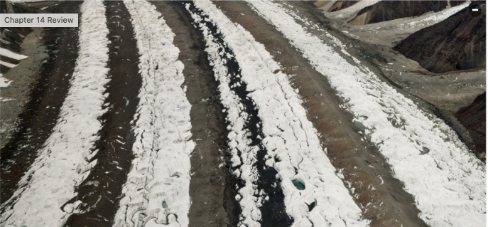
New cards
Deductive reasoning
Focuses on observation; involves logical conclusions drawn from general premises.
2
New cards
Inductive reasoning
Deals with inference; involves generalizing from specific observations.
3
New cards
Atacama Desert dryness
Caused by cold ocean currents and trade wind latitude, but not by intense evaporation.
4
New cards
Coriolis Effect
Influences Trade Winds and ocean gyres but not sinking polar air.
5
New cards

Features D
In landforms, refers to Terminal Moraine.
6
New cards
Wind-driven sediment transportation
Does not include Hoodoo; involves creep, saltation, and sliding stones.
7
New cards
Rifting
Current activity evident in the East Africa region.
8
New cards
NOT important in judging the credibility of a source?
Made by scientists who have never been wrong before
9
New cards
Clouds at the equator
Maintain speed due to inertia when blown northward.
10
New cards
Alpine glacier
Confined to a long, narrow valley in mountainous areas.
11
New cards
Ephemeral streams
Characteristic includes being dry much of the year and not being fed by groundwater.
12
New cards
Desertification feedback loop
Arid conditions kill plants, making soil less able to absorb moisture.
13
New cards
Tributary glaciers
Five tributary glaciers join to form the trunk glacier.
14
New cards
Plate sinking evidence
Lines of progressively-deeper earthquakes near arcs and trenches.
15
New cards
Glacier melting effects
Leads to isostatic rebound of land and rising sea levels.
16
New cards
Coriolis Effect wind deflection
In the Northern Hemisphere, wind deflects to the right.
17
New cards
Dominant erosion agent in deserts
Water is more effective than dust storms and wind.
18
New cards
Earth layers description
Asthenosphere moves plates, outer core is the only liquid layer, lithosphere is made of plates.
19
New cards
Glacier advancement factors
Global warming hinders glacier advance.
20
New cards
Liquid magma creation
Occurs in subduction zones.
21
New cards
What separates pseudoscience from science?
Concepts in science must be falsifiable.
22
New cards
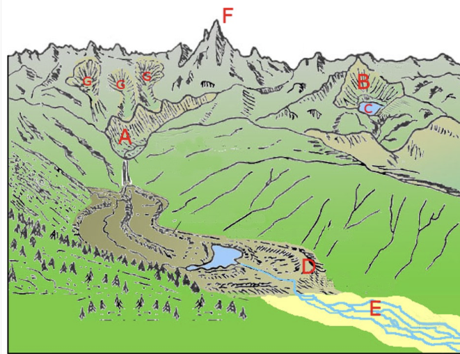
Features F
Identified as a Horn in glacial landforms.
23
New cards
Transform fault example
San Andreas fault separates the Pacific Plate and North American Plate.
24
New cards
Desert dune characteristics
Cross bedding is most characteristic of dunes.
25
New cards
Desert landform similarity
Alluvial fan is similar to a river delta.
26
New cards
Glacier definition
An iceberg is NOT considered a glacier.
27
New cards
Plastic deformation
A material bends or flows when stressed by a force.
28
New cards
Faster rotating location
Brazil moves faster in the context of Earth's rotation.
29
New cards
Sandstone composition observation
The observation that 23% is quartz is a quantitative and objective observation.
30
New cards
Uniformitarianism inconsistency
A large asteroid impact led to mass extinction is NOT consistent with uniformitarianism.
31
New cards
Aristotelian empiricism
Fell out of favor as it relied on evidence only observable by human senses.
32
New cards
Transform boundary motion
Plates move by slipping past each other.
33
New cards
Uniformitarianism assumption
Processes have always followed the same set of rules of nature.
34
New cards
Glacial striations cause
Grains of rock in ice grind against bedrock.
35
New cards
Ice Age trigger
Milankovitch Cycles cause glacial cycles.
36
New cards
Shallow earthquakes indicator
Often indicate a transform plate boundary.
37
New cards
Continental plate vs oceanic plate
Continental plates are ductile and can flow internally.
38
New cards
Igneous rocks formation
Igneous rocks form by crystallization.
39
New cards
Desert landscape sequence
Correct order: Alluvial Fan > Bajada > Inselberg.
40
New cards
Importance of piercing points
They track movement along transform boundaries.
41
New cards
Mid-ocean ridge danger level
It is the least likely to be dangerous to humans.
42
New cards
Drainage basins
Areas from which streams collect water separated by topographic highs.
43
New cards
Focus of an earthquake
Where the rupture of rock occurs beneath the Earth's surface.
44
New cards
Objective statement
An unbiased observation, e.g. 'I observed that it rained yesterday'.
45
New cards
Seismic intensity localization
In a horst-graben situation, seismic shaking is greatest in valleys.
46
New cards
Importance of objective observations
Help remove bias in scientific investigations.
47
New cards
Transform boundaries uniqueness
Characterized by fewer volcanoes compared to other boundaries.
48
New cards
Evidence against uniformitarianism
Banded iron formed as oxygen entered the atmosphere.
49
New cards
Antarctic ice sheet thickness
Can reach up to 13,000 feet thick.
50
New cards

Feature A
Identified as a Hanging Valley in glacial features.
51
New cards
Oceanic crust movement
As it moves away from the mid-ocean ridge, it gets colder.
52
New cards
Asthenosphere location
Is farthest from the surface during continental collisions.
53
New cards
Liquefaction requirements
Saturated unconsolidated sediment is necessary for liquefaction in earthquakes.
54
New cards
Driest state in America
Nevada holds the title of the driest state.
55
New cards
Theory definition
A well-tested and accepted concept in science.
56
New cards
Galileo's discovery evidence
Moons orbiting Jupiter proved Earth could not be the center of the universe.
57
New cards
Glacier advance definition
Terminus shifting forward indicates glacier growth.
58
New cards
Season affecting glacial budget
Summer controls the glacial budget with advance and retreat.
59
New cards
Ductile deformation location
Occurs in the lower part of the glacier where stress exceeds 100 kilopascals.
60
New cards
Earthquake location determination
Triangulation is used to determine earthquake locations.
61
New cards
Hot-spot volcanism difference
Hot spots display age trends compared to plate tectonic volcanism.
62
New cards
Hawaiian hot spot uniqueness
Different tectonic plate interactions set it apart from Yellowstone.
63
New cards
East coast seismicity explanation
Not near a plate boundary hence fewer earthquakes.
64
New cards
Quantitative data preference
Reveals trends for better analysis in scientific conclusions.
65
New cards
Dune type with limited sand
Barchan dunes indicate limited sand supply and constant wind.
66
New cards
Desert landform and salt flats
Playa is most associated with salt flats.
67
New cards
Desert weathering product
Desert varnish is a result of desert weathering.
68
New cards
Water budget definition
Compares precipitation to evaporation and discharge in hydrology.
69
New cards
Great Basin desert cause
Resulting from rain shadow and latitude.
70
New cards
Glacier base behavior
Ice slides over bedrock on a thin meltwater film.
71
New cards
Desert weathering and erosion rate
Slower due to limited water availability.
72
New cards
Rift feature prediction
An ocean basin can form as a rift develops.
73
New cards
Richter scale energy relation
An increase of one corresponds to 32 times more energy released.
74
New cards
Coriolis Effect in the Southern Hemisphere
Hurricanes rotate clockwise as influenced by the Coriolis Effect.
75
New cards
Great Basin uniqueness
All water drains internally without reaching the ocean.
76
New cards
Saltation effect on sand grains
Generates rounding and frosting on the surface of saltating grains.
77
New cards
Inductive reasoning example
Discovery of a new mineral on Mars leads to new water hypotheses.
78
New cards
Ephemeral streams definition
Streams that are dry much of the year.
79
New cards
Inductive reasoning advantage
Focus on observation rather than conclusions.
80
New cards
Lake Bonneville formation cause
Resulted from less evaporation and more precipitation.
81
New cards
Crustal divergence feature
Mid-ocean ridges are associated with crustal divergence.
82
New cards
Continental subduction reason
Continents have lower density which prevents subduction.
83
New cards
Natural sandblasting effect
Yardang forms from natural sandblasting.
84
New cards
Continental collision mountain formation
Similar densities of plates prevent one from subducting beneath the other.
85
New cards
Liquid Earth layer
Outer core is the liquid layer of the Earth.
86
New cards
Event marking recent ice age onset
Closing of the gap between North and South America occurred about 3 million years ago.
87
New cards
Seismic shaking measure
Mercalli Scale measures qualitative seismic shaking.
88
New cards
Feature G identification
Identified as a Cirque in glacial landforms.
89
New cards
Scientific method hypothesis process
Hypothesis development typically follows observation.
90
New cards
Science deniers arguments
Do not generally present alternative scientific data.
91
New cards
Geologic conclusion technique usage
Comparing ancient rocks and fossils to modern counterparts.
92
New cards
Crust age towards mid-ocean ridge
The crust gets younger as you approach mid-ocean ridges.
93
New cards
Deep Earth information source
Seismic waves provide the most direct information about the Earth's interior.
94
New cards
Wegener's hypothesis support lack
He couldn't provide a mechanism for continental drift.
95
New cards
Glacial evidence in valleys
A U-shaped valley with a broad bottom suggests glacial occupation.
96
New cards
Wilson Cycle sequence after collision
Rifting is likely to occur after continental collision.
97
New cards
Deepest earthquake location
Subduction zones are associated with the largest and deepest earthquakes.
98
New cards
Post-experimentation process in scientific method
Typically involves peer review.
99
New cards
Transform faults movement
Move left (sinistral) and right (dextral).
100
New cards
Ice age solar energy reflection reason
The albedo effect from ice and snow is primarily responsible.