Geohazards 1 (edit from Dianne)
 Call Kai
 Learn
Learn Practice Test
 Spaced Repetition
 Match
Match Flashcards
 Knowt Play
1/98

There's no tags or description
Looks like no tags are added yet.
Name | Mastery | Learn | Test | Matching | Spaced | Call with Kai | Chat |
|---|
No analytics yet
Send a link to your students to track their progress
99 Terms
Geohazards
Disasters and Geological Hazards
Earthquakes
Volcanic Processes
Landslides and Land Subsidence
Flooding
Sea Level Rise & Climate Change
Earth Materials
Extraterrestrial Hazards
Geology and Society: Challenges
Dwindling non-renewable resources
Environmental degradation through mining and other human activities
Human survival and the threat of geologic hazards
Geologic hazard (Geohazard)
Potentially destructive process that could harm man and his resources
Natural vs Man-made
Disaster
-No people & resources at risk → may have hazard but no disaster
-No hazard → no disaster
A function of hazard, people & resources at risk
Earthquake
The vibration of the earth, caused by the rupture and sudden movement of rocks that have been strained beyond their elastic limits.
-occur along plate boundaries
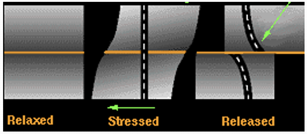
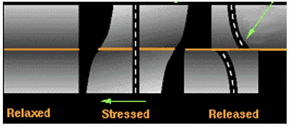
Elastic strain is recoverable portion like an elastic band being pulled
Rocks are subject to stress → rocks can rupture or slip and release elastic energy
Slip on old fault occur when stress > frictional forces
New fault occur when stress > strength
Explain: Elastic Rebound Theory
Slip rate and recurrence interval of faults
a function of:
Rate of motion
Friction or strength
(and cohesive strength of rocks)
Tectonic Earthquakes
Earthquakes associated with:
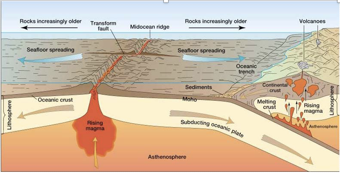
-Plate boundaries (subduction zones, mid-oceanic ridges, transform faults)
-Active Faults or faults that show movement over the last 10,000 years
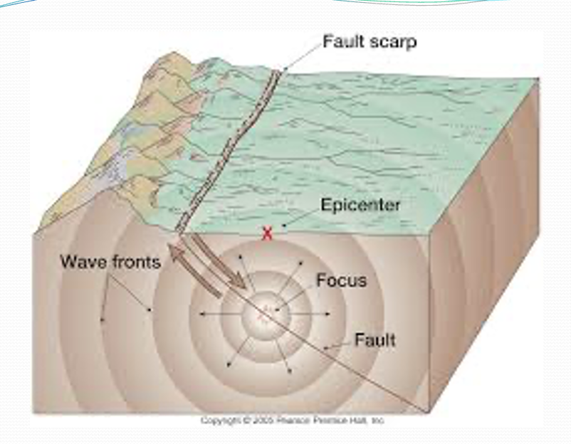
Parts of an Earthquake
-Fault line/scarp
-Focus: point of origin or main source
-Epicenter: point directly above the focus which lies on the surface of the earth
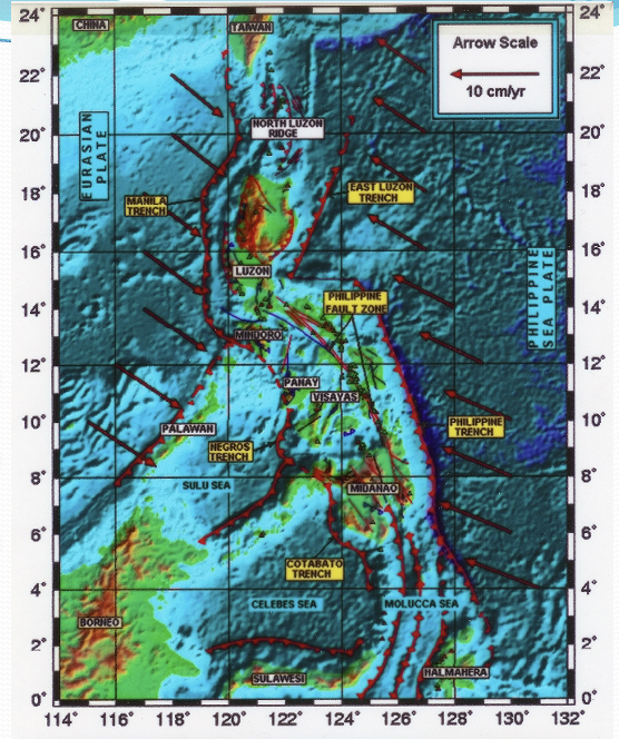
-subduction zones
-trenches
Earthquake Generators of the Philippines
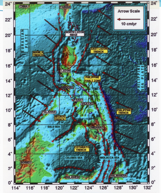
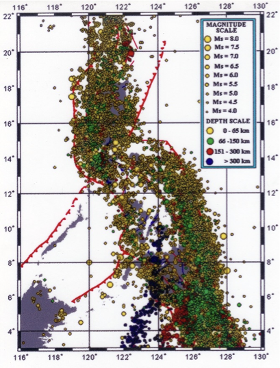
Seismicity of the Philippines
-shallow earthquakes are the most destructive
-most stable part of the Philippines is Palawan
Seismicity of the Philippines
-shallow earthquakes are the most destructive
-most stable part of the Philippines is Palawan
Earthquake Hazards
Ground Rupture
Ground Shaking
Liquefaction
Fire
Landslides and related downslope movements
Subsidence
Flooding due to dam failure
Ground Rupture
the visible offset of the ground surface when an earthquake movement along a fault affects the Earth's surface
-Digdig Fault, Nueva Ecija; July 1990
Ground Shaking
The vibration of the ground during an earthquake
-collapse of structures
-“pan-cake” effect for multistory building
-Kobe, Japan; 1995
Liquefaction
a process by which water-saturated sediment temporarily loses strength and acts like a fluid due to Earthquake shaking
-occurs in underlain by soft and unconsolidated material containing water
-the sand acts like a quicksand
-Dagupan, Pangasinan; 1990
Fire
Indirect effect
Can be devastating
Eg. Tokyo, 1923
Fire
Indirect effect
Can be devastating
Eg. Tokyo, 1923
Landslides and related downslope movements
Effect of Earthquakes on sloping areas which are unstable
Subsidence
the gradual caving in or sinking of an area of land.
-in coastal areas underlain by soft, unconsolidated material are subject to this
-very similar in process to liquefaction
Flooding due to dam failure
Fire
Indirect Effects of Earthquakes
Earthquake-Generated Tsunami
Occurs when earthquakes earthquake epicenter is offshore, specifically when there's a vertical component in the sense of motion of the fault blocks
Caused by vertical motion of seabed or submarine landslide
Travel times for tsunamis from Hawaii to/from other circum-Pacific spots
1998 Irianjaya
Caused by vertical motion of seabed or submarine landslide
Small wave at sea (< 1 m) but fast (® 800 km/hr)
As → shallow water slow to ~ 60 km/hr and height ® 20 m!
1960 Chile earthquake → tsunami that hit Hawaii 15 hrs later and killed 61 people
Hawaii and other areas have tsunami warning systems and beach signs
NW: Finding ancient tsunami deposits at coast and Puget Sound
Olympic coast very dangerous (no news or escape)
Considering a system for Alaskan and Cascade earthquakes using times and tide gauges
Tsunami Propagation
one of the blocks you have vertical motion and displaces water upwards and then it is generated in all direction
if you're at sea you will hardly notice this waves
the problem is when this waves approach the shore
you will observe that when a tsunami arrives there's a retreat of sea water and then it will come back as a tsunami inundating the land
Engineering solutions
How to prevent collapse?
-Shear wall and use of reinforced concrete & steel
Redundancy/regular shape in architecture
-Computer controlled dampeners
-Shock absorbers between buildings
-Design: natural ground vs building frequency (Avoid buildings with similar ground frequency)
-(building “heart beat” and resonance)
Earthquake Prediction
Preparedness is emerging as an alternative.
Seismic risk map
Strict building code
Zoning and land use
Earthquake Prediction
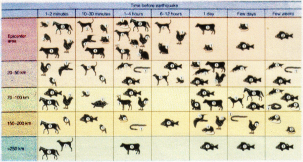
Unusual Animal Behavior
Use of Side-Aperture Radar (SAR) interferometry and GPS
Precursors
Use of seismic gaps
Earthquake Prediction: Unusual Animal Behavior
Earthquake Prediction: use of SAR interferometry and GPS
when rocks are being stressed, there is strain and deformation of the ground which is measured by these tools
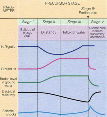
Earthquake Prediction: Precursors?
stage 1, 2, 3, and 5
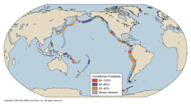
Earthquake Prediction: use of seismic gaps
Using portions of Earth where Earthquakes have not occurred for a long time despite known frequent occurrence. Especially observed in the pacific ring of fire. Probability estimated from theorized stored elastic energy.
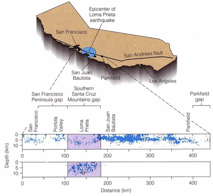
Seismic Gaps in the northern San Andreas Fault
A panel of experts concluded that there is a 67 percent chance for at least one earthquake of magnitude 7 or larger in the San Francisco Bay Area between 1990 and 2020 (but that a repeat of an M8.3 like the 1906 earthquake is unlikely in this period)
Issue #1: How to evacuate megacities?
Transport for millions of people???
To where? How far?
Evacuation route?
Traffic jams management?
Food and drink for millions? For how long?
Issue #2: Who will be left behind?
Security of properties?
Earthquake Prediction: Issues and Problems
Earthquake Intensity
qualitative measure (descriptive); effects on the Earth’s Surface and on humans and their structures. (e.g., based on survey)
for the same earthquake, _______ varies with distance from the epicenter and type of underlying rock
Earthquake Magnitude
quantitative measure, in terms of absolute amount of energy released
for any one earthquake, there is only one ______(unique)
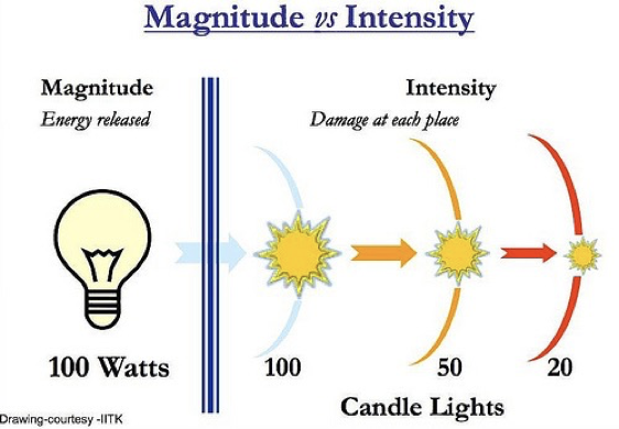
Magnitude vs Intensity
only 1 magnitude while intensity varies with distance
intensity decreases as distance increases
Intensity as a function of Underlying Rock
crystalline/hard rocks - less shaking of ground
loose and unconsolidated rocks - more shaking
water saturated sand and mud amplifies the shaking
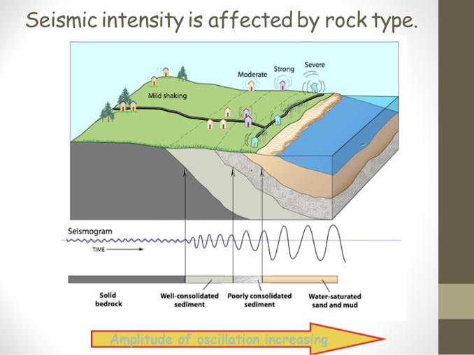
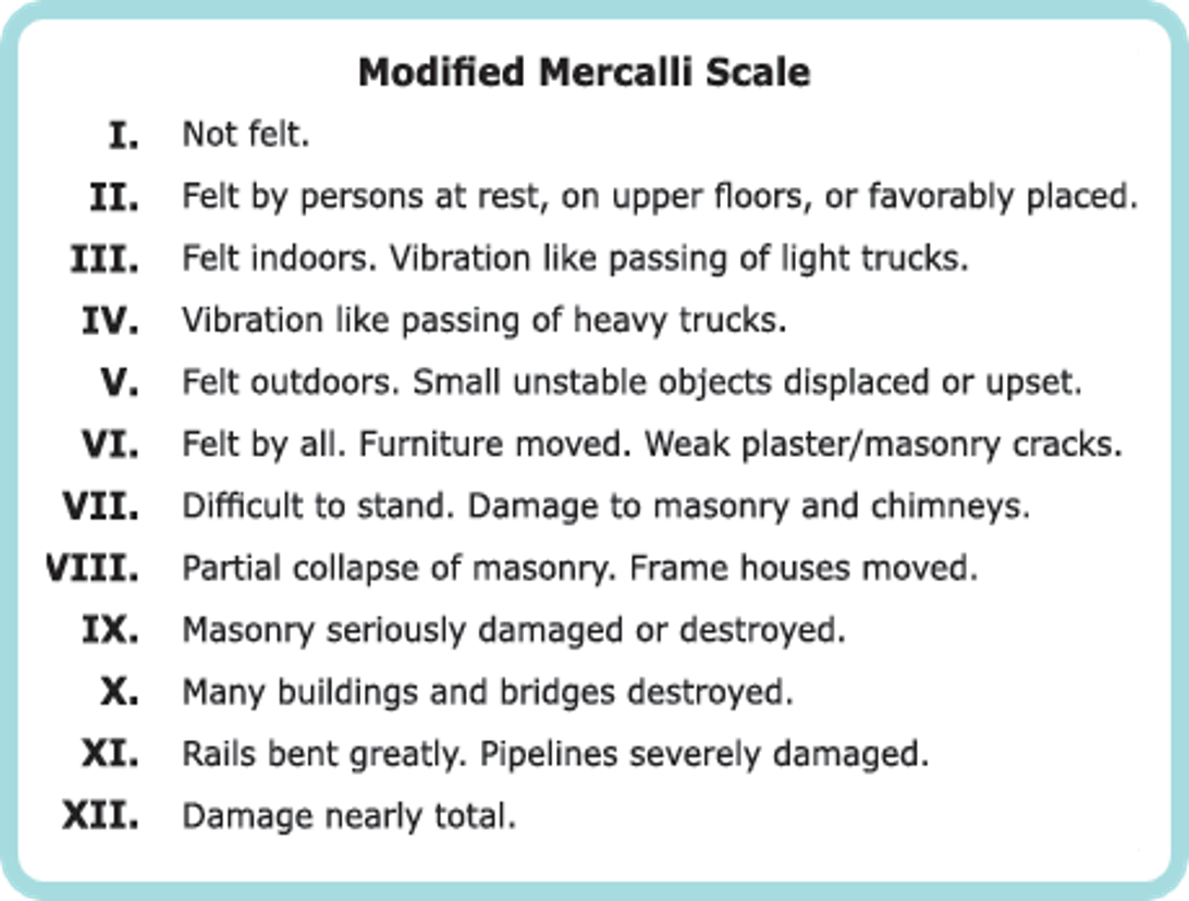
Modified Mercalli Scale
Scale for Intensity
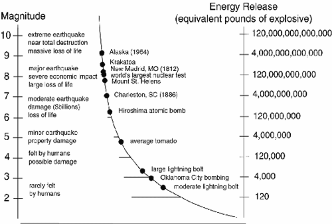
Earthquake Magnitude
absolute energy released during an earthquake
Volcanoes
-formed along plate boundaries (convergent and divergent)
-formed in the middle of plates (hotspot volcanoes, e.g., in Hawaii)
Plate Tectonics and Volcanism
-volcanoes form when tectonic plates collide and one plate is pushed beneath the other (convergent plate boundary)
-partial melting occurs when water from the subducted ocean sediment lowers the melting temperature of the mantle, giving rise to melt
-when tectonic plates move away from another to produce volcanoes (divergent plate boundary)
-the compression occurs when confining pressure is released due to blade separation hot magma rises from the mantel at the mid-oceanic ridges pushing the plates apart this molten rock then rises to the surface and erupts in volcanoes
-Hot spots can be either oceanic (Hawaii) or continental (CRB, Yellowstone)
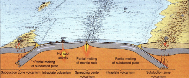
Hotspots or Hotspot activity
in the middle of the plates some areas of the mantle are anomalously of high temperature to cause melting
some of the voluminous eruptions were formed these volcanoes for example the decan traps associated with the extinction of dinosaurs which occurred at the same time and the other one is the siberian traps found in siberia
Volcanism (Hot Spots)
Implications: Plates move, as can be traced from the direction of the Hawaiian volcanic region.
The hot spot remains stationary, the islands were once on top of it, supplied with magma from below
model for hawaiian volcanism it's the most famous hotspot in the world
the plates move on top of a stationary magma source
a famous example of hotspot volcanoes in hawaii are those that form the chain of islands
it is the northwest north trending mechanic chain that can be traced from the emperor seamount chain where volcanoes increase in age
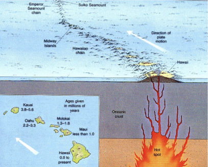
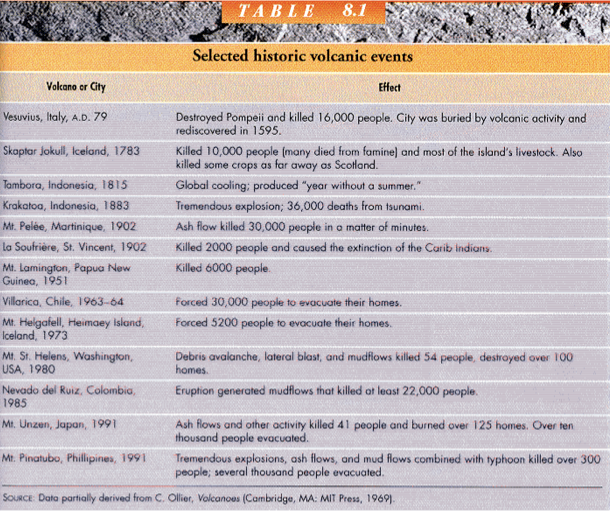
Table of Selected historic volcanic events
Internal factors
- vesiculation or degassing of magma (allows escape of magma from the melt??)
- influx of fresh magma supply and buoyancy of magma
External factors
- load pressing
- tectonic pressures
- ocean tides and earth tides
What Causes Volcanic Eruptions?
What comes out of a volcano?
Lava - molten rock coming from magma (only when extruded on the surface)
Pyroclast (fragmented magma) = tephra (fragments ejected through air by volcanic process)
- Example of pyroclast: pumice
Volcanic gases - made up of silicon, oxygen, aluminum, and other elements
Volatiles
gasses dissolved in magma are called ___
Eruption Products
Lava Flow
Pyroclasts: Pumice, Ash (Tephra/Ash fall)
Pyroclastic Flow and Deposits
Volcanic Gases
Lava Flow
the surface of the lava flow is fragmental and this is quite common but the interior is normally coherent when this lava was being erupted
Typically glows during an eruption and is visible at night
Pyroclast
derived from the greek terms meaning fire and broken
this mainly are derived from explosive eruption
occur in different sizes such as volcanic bombs as large as cars or houses
Pumice is produced when lava with very high water content is discharged from a volcano
A fragment of volcanic material that is ejected during explosive volcanic eruptions. These fragments can be molten, partially molten, or solidified magma.
Volcanic Ash
very fine as clay and sand
fine dust of volcanic rock
Pyroclastic Flow and Deposits
Pyroclastic flow is fast moving current of hot gas and volcanic matter collectively known as tephra that flows along the ground away from the volcano at high velocities of 100 kilometers per hour
Volcanic Gasses
principle components are water vapor (most abundant), CO2, H2S, nitrogen, argon, helium, methane, carbon monixide and hydrogen
H2S or hydrogen sulfide is the most toxic which can be fatal when inhaled in large quantities
there are some cases when volcano releases gasses (e.g. carbon dioxide) without any accompanying eruption
Types of Eruption
Explosive
Effusive
Explosive Eruption
characterized by gas-driven explosions that propels magma and tephra
e.g. 1991 mount pinatubo erruption
Effusive Eruption
characterized by outpouring of lava without significant explosive activity
e.g. kilauea volcano in Hawaii
Volcano Explosivity Index or VEI
a logarithmic scale from 0 to 8 that measures the relative size of explosive volcanic eruptions based on ejecta volume, eruption cloud height, and qualitative descriptions
Plinian Eruption
most explosive among the types of volcanic eruptions characterized by a high-speed column of gas and ash that can reach tens of kilometers into the atmosphere (>25km above crater)
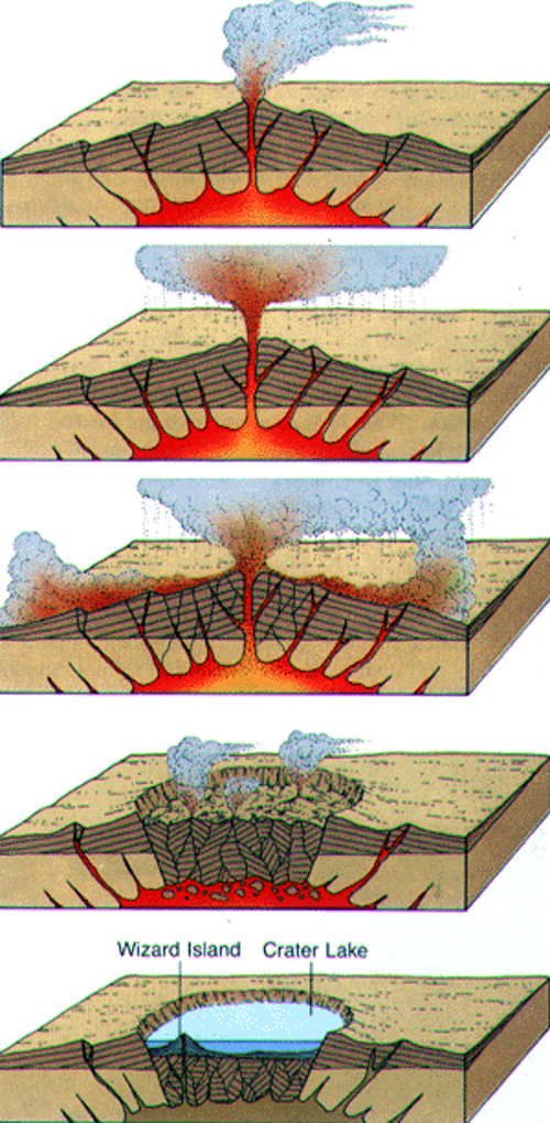
Caldera
Morphological feature, product of a Plinian Eruption, (most explosive eruptions)
largest volcanic landform on Earth
large depression formed by the collapse of a wide area due to the emptying of the magma chamber
Volcano with a crater greater than 2 km in diameter
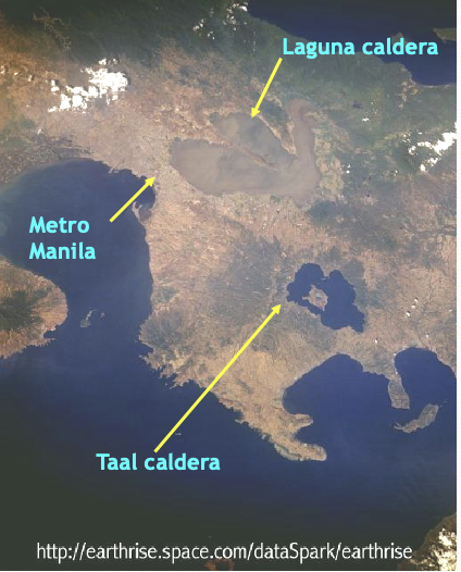
e.g. Laguna de Bay, Taal Volcano, Crater Lake, Oregon
Laguna and Taal calderas
Laguna caldera is much older than Taal caldera
Huge Rhyolitic Eruptions
A rhyolitic eruption is a powerful, explosive volcanic event driven by highly viscous, silica-rich magma that traps large amounts of gas. These eruptions are among the most destructive and can produce vast ash columns and extensive pyroclastic flows, sometimes leading to the formation of large calderas.
Mount Pinatubo erruption in 1991 is the third largest eruption in the century with 5km3 magma volume
Yellowstone Caldera (600,000 years ago) produced 2000km3 magma volume
Long Valley Caldera (760,000 years ago) produced 600lm3 magma volume
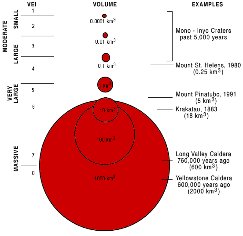
Volcanic Hazards
Lava flows
Tephra fall /Ash fall & Ballistics
Pyroclastic flows & Pyroclastic surges (PDCs)
Volcanic gases
Lahars
Debris avalanches, landslides, and tsunamis
Crater Lake/Mountain Lake breaching
Lava Flow: Burial
(Volcanic Hazards)
render land useless for decades
US Government turned the hazard into an opportunity in Hawaii by developing tourism
eruptions also provided additional land and space
Pyroclastic Flow and Pyroclastic Surge (PDCs)
(Volcanic Hazards)
Pyroclastic flow is a fast-moving current of tephra (hot gas and volcanic matter) that flows along the ground at high velocities (ave: 100kph, up to 700kph)
PDCs - pyroclastic density currents
dubbed as killers as they are the most dangerous process related to volcanic eruptions
contain hot solid (sometimes liquid) in gas dispersion
classified as density currents
main hazard is via Burial and Erosion
Death by asphyxia
a fast-moving current of tephra (hot gas and volcanic matter) that flows along the ground at high velocities (ave: 100kph, up to 700kph)
Mayon Volcano Eruption
June 24, 2001
the flows flowed along the streams on the slopes of the volcano mostly at the southeastern side
the pyroclastic flows are fed by glowing and collapsing pyroclast laden columns at the summit or at the crater
St. Pierre, Martinique: Mt. Pelee, 1902
worst volcanic disaster of the 20th century
Augustus Cybari
the lone survivor of the 1902 Mount Pelee eruption with 3rd Degree Burns
**
Tephra Fall/Ash Fall
(Volcanic Hazards)
cause collapse of roofs via accumulation
crop damage
eye irritant
respiratory problems
Ash and Hazards to Aviation
(Volcanic Hazards)
weight of ash when wet increases weight 3 times, collapsing supposedly safe structures
when an aircraft fly into an eruption cloud, engines can be damaged leading to engine failure mid-air
Global Cooling
(Volcanic Hazards)
pinatubo eruption produced colorful sunsets due to the reflection of light on the ash particles
aerosols including ash particles exert a cooling effect on the earth’s surface
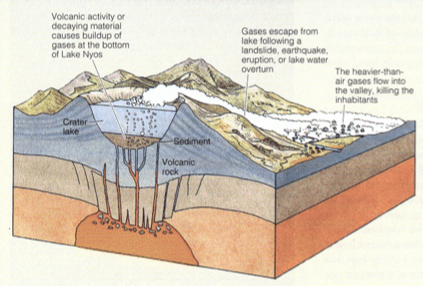
Noxious Gas - CO2
(Volcanic Hazards)
heavier than air
invisible
Lake Nios, Cameroon, 1986
Slow release by dormant volcano → bottom of lake in crater suddenly overturned and released CO2 which is heavy and hugged the ground suffocating
Limnic eruption in 1896 **
Lahar: Burial and Erosion
(Volcanic Hazards)
A fast-flowing torrent of (liquid) water and volcanic debris, such as mud, rock fragments, ash, and ice, that rushes down the slopes of a volcano
December 2006 Lahars, Mayon Volcano
lahar flowed on the slopes of Mayon Volcano
extreme rainfall due to super typhoon reming triggered lahars around Mayon Volcano
houses were buried in lahar
Crater Lake / Mountain Lake Breaching
(Volcanic Hazards)
Lake Maughan, Parker Volcano (September 6, 1995)
Pinatubo Volcano (July 10, 2002)
volcanic explosions as a trigger for flash floods
Debris Avalanche & Related Hazards
(Volcanic Hazards)
1980 Mount St. Helens Volcano was the most destructive in United States history
largest terrestrial landslide or debris avalanche reduced the summit of the volcano by 400m
Debris Avalanche Deposit
materials removed from the flank of a volcano
characterized by mounds
Hummocky Topography
signature topography of debris avalanche
landscape characterized by an irregular, rolling, or undulating surface of low, rounded hills (hummocks) separated by depressions
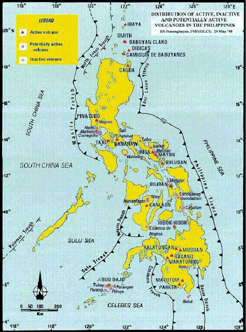
Philippine Volcanoes
23 active volcanoes and more than 400 inactive
most active is Mayon Volcano with 49 historical eruptions
7 active volcanoes are being monitored by PHIVOLCS
most volcanoes are subduction related; exotic types also exist, e.g. Amoguis Volcano in Palawan
Volcanoes in the Philippines
Volcano Monitoring
Volcano Observatories are set up on all active volcanoes that threaten the human population.
These are designed to monitor and potentially to predict the eruptive behaviour of the volcano in question.
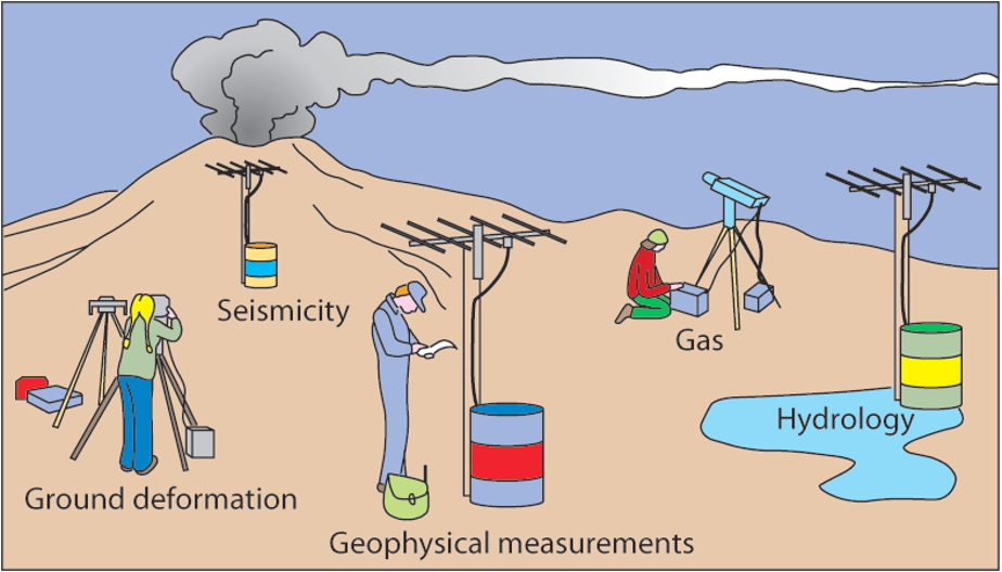
Precursors to an Eruption
Increased Seismicity
Deformation
Gas Output
(on volcano and remote sensing techniques)
Seismic Activity
(Precursors to an Eruption)
Earthquake activity commonly precedes an eruption
Result of magma pushing up towards the surface
Increase volume of material in the volcano shatters the rock
This causes earthquakes
Earthquake activity is measured by Seismographs
Seismographs are stationed on the flanks of the volcano
These record the frequency, duration and intensity of the earthquakes and report it back to the volcano observatory.
Deformation Monitoring
(Precursors to an Eruption)
“Tiltmeters” are used to measure the deformation of the volcano
The tiltmeters measure changes in slope as small as one part per million. A slope change of one part per million is equivalent to raising the end of a board one kilometer long only one millimeter!
Change in tilt indicates new magma entering magma chamber of the volcano (induces swelling). This is a precursor to eruption along with seismic activity/
Gas Monitoring
(Precursors to an Eruption)
Commonly gas output from a volcano increases or changes composition before an eruption.
As magma rises to the surface it releases (exsolves) much of its gas content.
This can be measured
Gas samples are collected from fumaroles and active vents.
Gas levels and types may also be monitored by remote sensing techniques indicating new magma in the chamber
Volcanism – Bad points
Hazards
1.Pyroclastic flow
2.Pyroclastic fall
3.Debris Avalanche
4.Lahar
5.Lava
6.Tsunami
7.Noxious gas
Volcanism – Good points
Benefits
Fertile soil
Valuable minerals
Water reservoirs
Geothermal energy
Scenic beauty
Landslides
general term for rapid downslope movements/failure
Mass Wasting
Is even more general and includes slow movements (creep, slow flows)
Mass wasting / slope failure / landslides – all downslope movement of rock and sediment that occurs at the surface of the earth (also underwater) in response to gravity. Speeds range from extremely fast to extremely slow.
Elastic Rebound Theory
Explains the energy released by an Earthquak
Slip (on old fault)
From elastic rebound theory, the effect when stress between rocks is greater than friction
New Fault
From elastic rebound theory, the effect when stress between rocks is greater than rock strength
Tectonic
Volcanic
Two types of Earthquakes based on generators
Volcanic Earthquakes
Frequent, Low-magnitude Earthquakes from rising magma fracturing rocks
Earthquake Intensity
Earthquake Magnitude
Two ways of measuring the strength of an Earthquake
1815 Tambora Eruption, Indonesia
Largest recorded Holocene eruption 180 km^3 of magma expelled
Vesiculation or degassing of magma
Most important cause of volcanic eruption
1. In the deep, high pressures mix gas and magma together as homogenous matter
2. Less dense magma rises over denser rocks beneath Earth surface
3. Gas separates in shallower regions with lower pressure, expanding magma
4. When too much pressure is built up on the surface, an explosion occurs breaking a weak spot in the Earth's crust, releasing lava in an eruption
Process of Vesiculation (Degassing of Magma)
Lava
Coherent molten rock coming from magma (magma when extruded on the surface)
Normally made up of crystals, volcanic glass, and bubbles
Pyroclast
(fragmented magma) = tephra
Fragmented Magma
Any volcanic fragments ejected through air by volcanic process (Example: pumice)
Volcanic gases
Gases released from Volcanoes, filled with tiny particles suspended in air
Made up of silicon, oxygen, aluminum, and other elements
Volcano Observatories
These are designed to monitor and potentially to predict the eruptive behaviour of the volcano in question.