2. Atmospheres info
 Call Kai
 Learn
Learn Practice Test
 Spaced Repetition
 Match
Match Flashcards
 Knowt Play
1/25

There's no tags or description
Looks like no tags are added yet.
Name | Mastery | Learn | Test | Matching | Spaced | Call with Kai | Chat |
|---|
No analytics yet
Send a link to your students to track their progress
26 Terms
Name the heights of each layer of the atmosphere
Troposphere = 0-10km
Stratosphere= 10-50km
Mesosphere = 50-80km
Thermosphere = 80km +
Explain diurnal energy budget
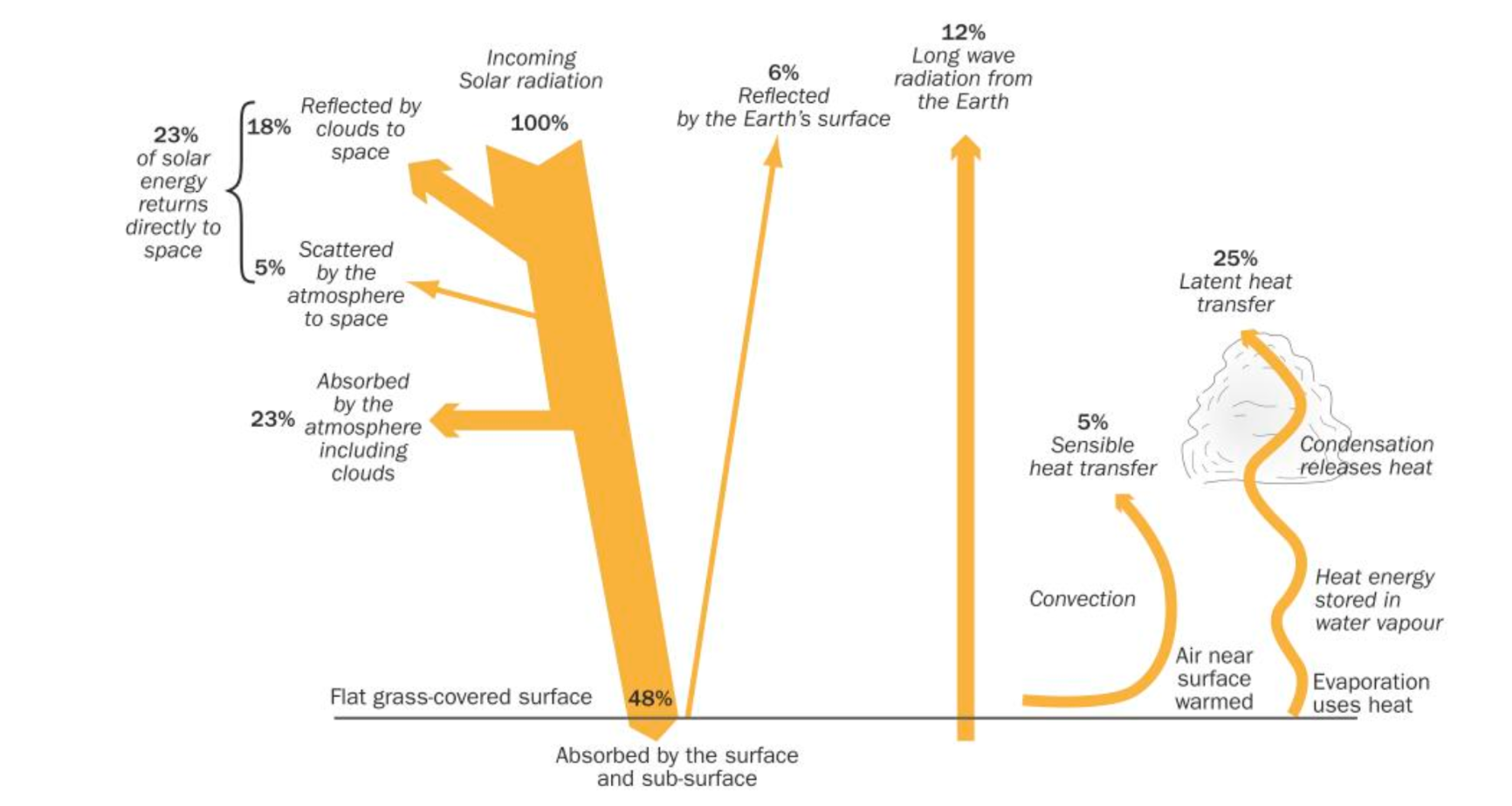
Types of cloud albedo affect
Cirrus clouds - thin and wispy - low albedo
Cumulonimbus clouds - thick so higher albedo
Stratus = low and thick clouds - highest albedo
Sensible vs latent heat transfer
Sensible = increase in air temp
Latent = energy held in changing of state
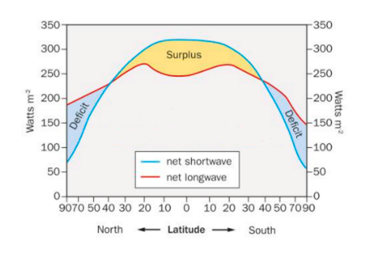
Explain this graph
Incoming short wave radiation decreases with latitude due to
Oblique angle of incidence
Travels through a longer distance of atmosphere
Higher albedo
Longwave changes based on insolation as this is what influences temperature of ground.
Dip in longwave near equator due to ITCZ.
What are geostrophic winds
Winds that travel parallel to isobars as the pressure gradient force is balanced with the Coriolis force
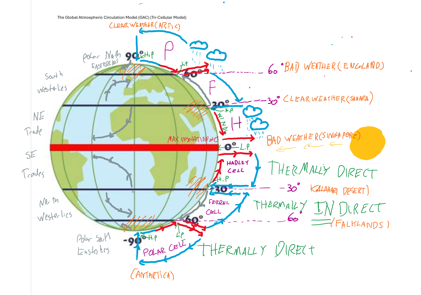
Name GAC cells from North to South explaining weather formations and pressure/direction of air
What drives ocean currents - rough model for their movement
Winds, tides, rotations of earth, changes in water pressure
Clockwise in NH, Anti-clockwise in SH in large circles
What role does the Great Ocean Conveyor Belt play in the development of heat circulation?
Distributes heat from hotter to colder regions
Define solstice and equinox
Solstice = longest/shortest day in year
Equinox = day and night are approx equal in length
Where and why is the thermal equator?
Usually, around 5N in July, Around equator or just below in January
Northern Hemisphere has more land
Land has low specific heat capacity so heats up and loses heat fast
Therefore, in NH land warms rapidly and surface temperature becomes higher
List all types of air mass and their characteristics
Polar - cold
Tropical - warm
Continental - dry - more extreme
Maritime - moist
Define continentality
Areas in centre of continents experience more extreme temperatures because moderating ocean currents do not reach there
Why does temperature change with altitude
Adiabatic cooling. 1C per 100m dry air, lower for saturated air
What are Rossby waves
Giant meanders in high altitude jet streams/winds
List all forms of cooling/fog
Radiation, advection, orographic, frontal, adiabatic
Explain radiation cooling
Ground loses heat rapidly by terrestrial long wave radiation - often on cloudless night
Moist air in contact with ground loses energy due to conduction
This causes temperature of air mass to drop below dew point
Excess moisture condenses to form radiation fog, dew and hoar frost
Explain advection cooling
Warm moist air moves over a cooler land or sea surface
This causes temperature of air mass to drop below dew point meaning condensation will occur
This forms advection fog and haar fog
Explain orographic rainfall
Moist air mass travels into mountain causing vertical movement of air
As air mass rises it cools due to adiabatic cooling, reaches RH of 100% and condenses
This forms clouds and precipitation on the windward side of the mountain
Air is now dry on Leeward side leading to a rain shadow
Foen Effect - adiabatic lapse rate of dry air is less than saturated air creating high temperatures on leeward side
Explain adiabatic cooling
A parcel of air rises
Air pressure decreases with elevation
Parcel of air will expand
Expansion causes molecules to spread out and cool
Bergeron-Findeisen theory vs Collision and Coalescence theory
BF - supercooled water collides with ice causing ice molecules to grow - when these are heavy enough they fall and melt as rain - cold sub zero conditions
CC - as water droplets move vertically past each other they combine into a larger droplet which eventually falls - tropical conditions
Ways we can record change in temperature of past and how far back can they track and how they work
Instrumental data - 150 yrs
Dendrochronology - 10,000 yrs
Ice cores - 1,000,000 years
Ocean sediment cores and foraminifera - many millions
All forcings for natural climate change
Sun spots - every 11 years - increase earths temp
Milankovic cycles
Eccentricity - every 100,000 yrs - elliptical orbits - more extremes
Obliquity - every 41,000 yrs - angle of earths axis changes - more extreme seasons
Precession - every 26,000 yrs - influences insolation received by each hemisphere over a year
Volcanic eruptions - months/years - reflect insolation causing global temperature drop
Human climate change influence - GHG/aerosols
GHG - enhanced Greenhouse effect as long wave radiation is absorbed and reradiated to earth
Aerosols - reflect insolation reducing temp
Ozone contribution to global warming
Does not contribute to global warming
allows more harmful UV in
What is El Nino
Weakening trade winds mean that the warm water that usually piles up on the West coast of Australia
This causes the colder parts of the ocean to warm and spread across the surface
this increases global temperature and increases risk of floods
La Nina isi nverse