CH 16 Weather Reports, Forecasts and graphics (INCOMPLETE)
 Call Kai
 Learn
Learn Practice Test
 Spaced Repetition
 Match
Match Flashcards
 Knowt Play
1/56

There's no tags or description
Looks like no tags are added yet.
Name | Mastery | Learn | Test | Matching | Spaced | Call with Kai | Chat |
|---|
No analytics yet
Send a link to your students to track their progress
57 Terms
METAR 151955Z
DDHHMMZ
DD = day of month, HH = hour, MM = Minute, Z = zulu
15 → 15th day of the month
19 → 19:00 (7 PM) UTC
55 → 55 minutes
METAR 32020G35KT 280V350
320 → wind is coming from 320° (northwest)
20 → sustained wind speed is 20 knots
G35 → gusts up to 35 knots
KT → units are knots
280V350 → wind direction is variable between 280° and 350°
METAR TSRA BKN009CB 16/14 A2987
TS = thunderstorm
RA = rain
BKN = broken clouds (5/8 to 7/8 of the sky covered)
009 = cloud base at 900 feet AGL
CB = cumulonimbus clouds (thunderstorm clouds)
16 = temperature 16°C
14 = dew point 14°C
A = altimeter setting (in inches of mercury)
2987 = 29.87 inHg
METAR RMK SLP001
REMARK
SLP = sea-level pressure (in hectopascals / millibars)
001 = coded value
To decode:
If the number is 000–499, add 1000
If 500–999, add 900
For SLP001:
001 is between 000–499 → add 1000
1000.1 hPa
Sea-level pressure is 1000.1 millibars (hPa)
METAR CODE Weather Phenomena
+TSRA = thunderstorm with heavy rain
-SHRA = light rain shower
MI = shallow
DR = low drifting (dust, sand, snow)
BL = Bloweing low drifting (dust, sand, snow)
TS = Thunderstorm
BC = Patches
FZ = Freezing
SH = Showers
PR = Partial
METAR CODE Precipitation
DZ = Drizzle
SN = Snow
IC = Ice Crystals
GR = Hail
RA = Rain
SG = Snow grains
PL = ice pellets (illegal)
GS = small hail
UP = unknown
METAR CODE phenomena that reduce visability
BR = Mist
FU = Smoke
SA = Sand
PY = Spray (ocean spray)
FG = Fog
VA = Volcanic Ash
HZ = Haze
DU = Dust
METAR CODE Obscuration
SS = Sand storm
SQ = Squall
DS = Dust Storm
FC = Funnel Cloud
+FC = Tornado/water spout
PO = well developed dust/sand whirls
METAR CODE Sky Conditions
Below is not ceiling:
SKC or CLR = Clear sky
Few = Few clouds
SCT = Scattered
Below are ceiling:
BKN = Broken
OVC = Overcast
VV = Vertical Visibility
CB = Cumulonimbus
TCU = Towering Cumulus
METAR CODES Lightning
Frequency:
OCNL = Occasional (less than 1 flash/min)
FRQ = Frequent (1-6 flashes/min)
CONS Continuous (More than 6 flashes/min)
Types of Lightning:
CG = cloud to ground
IC = in cloud
CC = cloud to cloud
CA = cloud to air
METAR CODE Ceiling
BCAT1 = celing below min (200ft) or vis less than ½ sm
LIFR = ceiling less than 500ft and or vis less than 1 sm
IFR = ceiling less than 1000 ft or vis less than 3 miles
MVFR = ceiling 1000 - 3000 ft or vis 3 - 5 sm
VFR = no ceiling or greater than 3000 ft and vis greater than 5 sm
METAR CODE special (SPECI)
special non routine aviation weather report if wind direction change by 45 degrees or more in less than 15 min, visibility decrease, runway visibility, tornado, thunderstorm, hail, freezing precipitation, ice pellets, volcano, squall
Squall
A squall is a sudden, sharp increase in wind speed lasting at least 1 minute, often accompanied by precipitation or storms.
Key characteristics:
Wind speed increases by at least 16 knots
Reaches 22 knots or more
Lasts at least 1 minute
Often associated with:
Thunderstorms
Heavy rain, snow, or hail
Rapid wind shifts
METAR
METAR = routine aviation weather report
Issued hourly (or half-hourly at busy airports)
Describes current weather conditions at an airport
Includes:
Wind
Visibility
Weather (rain, snow, etc.)
Clouds
Temperature/dew point
Pressure
✅ Simple: “What’s the weather right now at the airport?”
TAF
TAF (Terminal Aerodrome Forecast) = forecast of airport weather
Covers 24–30 hours into the future
Updated 4 times daily (typically)
Includes forecasts of:
Wind
Visibility
Weather
Cloud ceilings
Significant changes over time
✅ Simple: “What will the weather be at the airport?”
PIREP
PIREP (Pilot Report) = real-time weather report from a pilot
Given in-flight by pilots
Reports actual conditions experienced in the air
Includes:
Turbulence
Icing
Cloud tops/bases
Winds
Visibility
✅ Simple: “What is a pilot actually experiencing up there?”
METAR CODE Method
Nothing = Human
A01 = Automated station without precipitation discriminator
A02 = Automated station with precipitation discriminator
AUTO = automated (not specified)
AWOS
An Automated Weather Observing System (AWOS) is a, typically airport-based, suite of sensors and computers that provides real-time, minute-by-minute weather data for aviation safety, including wind, temperature, dew point, altimeter setting, visibility, and sky conditions
METAR SLP993
SLP993
Sea-level pressure (SLP) in millibars (hPa).
Formula:
SLP = 1000 + 993 / 10 = 999.3 hPaActually, in standard decoding: SLP993 → 999.3 hPa
Weather conditions expected to occur in the vicinity of the airport, but not at the airport, are denoted by the letters “VC.” When VC appears in a TAF, it covers an area of
5-10 sm radius of airport
What weather is predicted by the term VCTS in a Terminal Aerodrome Forecast?
Thunderstorms are expected in the vicinity. (5-10 SM, but not at airport)
Only cloud types forecast in the Terminal Aerodrome Forecast?
Cumulonimbus.
A calm wind that is forecast in TAF
00000KT
TAF KEY CODES
Code Meaning
FM1200 From 1200Z onward, conditions change (usually wind, weather, cloud)
TEMPO Temporary changes expected (less than 1 hour at a time)
BECMG Gradual change expected over a period
TX / TN Maximum / Minimum temperature forecast during period
What is the single source reference that contains information regarding volcanic eruption, turbulence, and icing conditions for a specific region?
In-Flight Weather Advisories.
What information is provided by a Convective Outlook (AC)
It provides prospects of both general and severe thunderstorm activity and specific severe weather threats during the following 8 days.
Maximum turbulence potential charts (GTG-3) are issued
hourly (06, 09, 12 hour forcasts which are update every 3 hours)
Isobars on a surface weather chart represent lines of equal pressure
reduced to sea level.
A prognostic chart depicts the conditions
forecast to exist at a specific time in the future.
U.S. High-Level Significant Weather Prognostic Chart is prepared for use
between 25,000 feet and 63,000 feet pressure altitude.
Forecast winds and temperatures aloft for an international flight may be obtained by consulting
Wind and Temperature Aloft Charts prepared by the U.S. National Centers for Environmental Prediction (NCEP).
What sources reflect the most accurate information on current and forecast icing conditions?
PIREP’s, AIRMET Zulu’s, and SIGMET’s.
A public severe thunderstorm watch implies
58 mph winds or greater and/or surface hail of 1 inch or more in diameter.
Analysis Heights/Temperature Chart, what is 500mb, 300mb, 200mb
MB stands for “millibars”, which is a unit of atmospheric pressure.
500 mb → about 18,000 feet
300 mb → about 30,000 feet
200 mb → about 39,000 feet
Constant Pressure Analysis Charts contain contours, isotherms, and some contain isotachs. The contours depict
ridges, lows, troughs, and highs aloft.
The vertical wind shear that is critical for probability of turbulence is
5 knots or more per 1,000 feet.
horizontal wind shear, critical for turbulence (moderate or greater) per 150 miles is
greater than 18 knots.
If a SIGMET alert is announced, how can information contained in the SIGMET be obtained?
By contacting the nearest FSS.
Which type weather conditions are covered in the Convective SIGMET?
Embedded thunderstorms, lines of thunderstorms, and thunderstorms with 3/4-inch hail or tornadoes.
SIGMETs may be issued for the contiguous U.S.
as convective SIGMETs when obscured thunderstorms are forecast.
Convective SIGMETs are issued for a line of thunderstorms at least
60 miles long with thunderstorms affecting 40 percent of its length.
Convective SIGMETs are issued for severe thunderstorms
occurring for more than 30 minutes of the valid period.
A SIGMET is issued when weather affects
3,000 square miles or more.
SIGMETs (other than domestic convective SIGMETs) may be valid for not more than
4 hours for other phenomena.
A SIGMET may be issued
for an area where conditions are deemed to have a significant effect on the safety of aircraft operations.
The Mid-Level Significant weather (SIGWX) Chart is used to determine an overview of flying weather conditions between what altitudes?
10,000 feet MSL and FL 450.
The Federal Aviation Administration’s Flight Information Service Data Link (FISDL) is designed to provide data on a common frequency to flight crews from
17,500 feet MSL down to 5,000 feet AGL.
The Federal Aviation Administration’s Flight Information Service Data Link (FISDL) provides what products?
METARs, SIGMETs, PIREPs, and AIRMETs.
The Federal Aviation Administration’s Flight Information Service Data Link (FISDL) products, such as ground radar precipitation maps, are
not appropriate for finding a path through a weather hazard area.
What weather database can a dispatcher access concerning wind shear activity at an airport?
TWIP
En route weather advisories should be obtained from an FSS on
122.2MHZ
What info is provided by a convective Outlook (AC)?
It provides prospects of both general and severe thunderstorms activity and specific severe weather threats during the following 8 days
The Federal Aviation Administration’s Flight Information Service Data Link (FISDL) is designed to provide data on a common frequency to flight crews from
17,500 feet MSL down to 5,000 feet AGL.
What wind direction and speed aloft are forecast by this WINDS AND TEMPERATURE ALOFT FORECAST (FB) report for FL 390 - “731960”?
731960
73 = wind direction
19 = wind speed
60 = temp
if first two is 50 - 99, subtract 50 from direction and add 100 knots to speed
73 - 50 = 23, 19 + 100 = 119
Wind direction = 230 degrees and wind speeds 119 knots
A station is forecasting wind and temperature aloft to be 280° at 205 knots; temperature –51°C at FL 390. How would this data be encoded in the FB?
But for winds ≥ 100 knots, use the special rule:
Add 50 to the wind direction (DD)
Subtract 100 knots from the speed (SS)
Temperature is always included at FL390
Direction: 280° → 28 → 28 + 50 = 78
Speed: 205 − 100 = 105 → last two digits = 05
Temperature: −51 → 51
780551
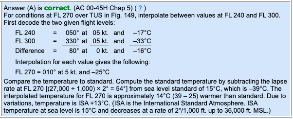
What approximate wind direction, speed, and temperature (relative to ISA) are expected for a flight over TUS at FL 270?
24,000 30,000
0505-17 330533
010° true; 5 knots; ISA +13°C.
WILL ADD INFO FOR TAF AND PIREP!!!!!!!
WILL ADD INFO FOR TAF AND PIREP!!!!!!!