Water Sciences Unit 1
 Call Kai
 Learn
Learn Practice Test
 Spaced Repetition
 Match
Match Flashcards
 Knowt Play
1/40

Earn XP
Description and Tags
WATS 281 UNL
Name | Mastery | Learn | Test | Matching | Spaced | Call with Kai | Chat |
|---|
No analytics yet
Send a link to your students to track their progress
41 Terms
Distribution of All Water on Earth
Ocean: 97%, Freshwater: 3%
Distribution of Freshwater on Earth
Ice caps/Glaciers: 69%, GW: 29%, Accessible Surface Freshwater: 1%
Distribution of Accessible Surface Freshwater
Lakes: 52%, Soil Moisture: 38%, Water Vapor: 8%, Rivers: 1%, Living Organisms: 1%
Water Balance Equation
P + SWin + GWin = E + T + SWout +GWout + ΔS
Watershed
Area that appears on the basis of topography to contribute all the water that passes thru a given cross-section of a stream
Divide
Surface trace of the boundary delimiting a watershed
Drainage Area
Horizontal projection of the area of a watershed
At or above the cross-section
4 Types of Uplift
Orographic Uplift
Convective Uplift
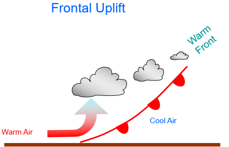
Frontal Uplift
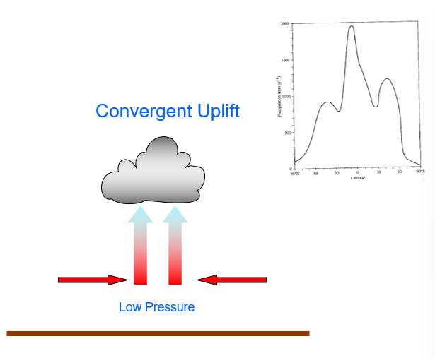
Convergent Uplift
Areal Estimation (3)
Arithmetic Average
Thiessen Polygons
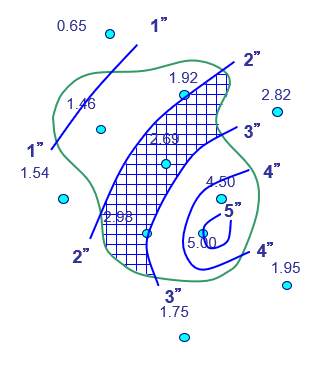
Isohyetal Method
Orographic Uplift

Convective Uplift

Frontal Uplift
Convergent Uplift
Arithmetic Method
Areal Estimation
For multiple stations in a watershed
Add the rainfall amounts at each station within the basin, and divide this total by the number of stations to get the average value

Thiessen Method
Areal Estimation
For multiple stations in a watershed
Connect stations with dashed lines
Bisect each dashed line with a solid line
Connect the lines to form the polygons
Determine the area of each polygon
Determine the weighted precipitation total for each polygon
Sum the data

Isohyetal Method
Areal Estimation
For multiple stations in a watershed
Contour the stations using lines of equal intensity (1 in, 2 in, etc)
Determine the area of each contour band
Determine the weighted precipitation total for each polygon
Sum the data
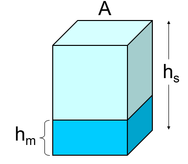
Snow Water Equivalent (hm)
Amount of water the snow actually contains and yields when melted
hm ≡ Vm / A
hm = (rs / rw) · hs
Factors Affecting Runoff (3)
Climate
Phys Characteristics of Watershed (Drainage Basin)
Land Use (Human Alterations)
Physical Characteristics of a Watershed (4)
Elevation and Orientation of Basin
Topography
Veg and Soil Type
Geology
Effects of Geology on Watersheds - Drainage Types (5)
Dendritic drainage
Centripetal drainage
Rectangular drainage
Radial drainage
Trellis drainage
Discharge (Q)
The volume rate of flow [L3/T] thru a stream cross-section at right angles to the flow direction
Process of measuring stream discharge = stream gaging
![<p>The volume rate of flow <span>[L<sup>3</sup>/T] thru a stream cross-section at right angles to the flow direction</span></p><ul><li><p><span>Process of measuring stream discharge = stream gaging</span></p></li></ul><p></p>](https://assets.knowt.com/user-attachments/cd4a721a-8349-4637-9366-89d3ffdf865b.png)
ET Formula
ET = P - SWout - GWout
Energy Balance

Hydrologic, Energy, and Radiation Balance

Aquifer
Subsurface geologic unit that stores and transmits water
2 Types:
Unconfined (Water table)
Confined (Potentiometric Surface)

Henry Darcy
Found that Discharge (Q) increased when the change in head (H1 - H2) was increased, and decreased when the head was decreased
Q decreased when the length (L) btn the 2 points where the head was measured was increased, and increased when L was decreased
Q increased when the cross-sectional area (A) of the column (cylinder) was increased, and decreased when A decreased
If (H1-H2) and L were constant, Q was larger for some soils and smaller for others
Accounted for this relationship with a coefficient for each different soil type that he put in his column - Hydraulic Conductivity of a material (K)
Darcy measured:
High K’s for very porous loose soils
Low K’s in very tight, compacted soils
Q is a function of: f(H1-H2, L, Length, Area, Material)

Henry Darcy Equation/Darcy’s Law
Q = Discharge
K = Hydraulic conductance
A = Area
H1-H2 = Hydraulic gradient
L = Length

Water Balance Concept - Conservation of Mass
Inputs = Outputs ± Change in Storage
I = O ± ΔS
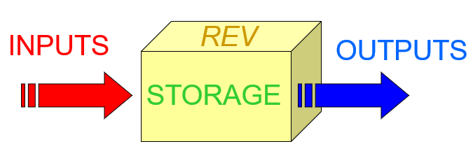
REV
Representative Elementary Volume
Ex: soil, lake, watershed
Precipitation and ET as:
Water Depth
mm or in
Stream Flow and GW as:
Rate or Velocity or Discharge
m/sec; ft/day; m³/day)
Storage as:
Volume
Liters, Gallons, Acre, Ft
Potential ET
Amount of water demanded by atm conditions (ie input rad)
Actual ET
Actual amount of ET that the land surface exchanges with the atm
For plants: PET is roughly AET in well-watered conditions where there is enough water in the root zone to meet the atm demand
Primary factors controlling the rate at which water will infiltrate into the ground following a rain event:
Rainfall amount and rate
Antecedent moisture conditions
Slope
Soil type
Soil hydraulic conductivity
Confined Aquifer
Energized - the pressure exerted on an open well would result in the height of the well being above the water table under atm conditions
Have potentiometric surfaces
Potentiometric Surface
Height at which the water in a well would rise due to pressure forces
Hydrology
Predicts the occurrence, circulation, and distribution of water of the earth and its atm
Global cycle includes: Terrestrial, Oceanic, and Atm
Inputs - Water Balance
Precipitation
Rain, Snow/ice, Fog/mist
Surface water
Runoff (overland flow), Soil water (interflow)
Groundwater
Outputs - Water Balance
Evaporation
Open water, Bare soil, Leaf/Plant surfaces)
Transpiration
Ground water
Surface Water
Runoff (overland flow)
Soil water (interflow)
Storage
Storage - Water Balance
Atmosphere/Clouds
Lakes/Rivers/Reservoirs
Glaciers
Canopy/Biomass
Soil Moisture
Aquifers (GW)
Ocean