2b: Spatial Interactions
1/37
There's no tags or description
Looks like no tags are added yet.
Name | Mastery | Learn | Test | Matching | Spaced | Call with Kai |
|---|
No study sessions yet.
38 Terms
what influences accessibility (2)
knowledge
cost
define spatial interactions
how people, goods, or ideas move from one place to another & how connected places are
movement between 2 or more places
what affects spatial interactions (3)
new transport mode
airplanes, high speed trains
infrastructure
roads, railways, airports
affordability
cheaper transport = more people can travel
what influences humans use of space
perceptions of a place
decision making for migration (do people think its safe, fun, rich, poor?)
marketing
affects where they move/shop
distance & perception of distance
a place may be close physically, but if its hard to reach (cost, homes, education) it feels far
why do geographers care about spatial interactions
to understand:
how space is used
why people move or want to connect between places
define “use of space”
→ how human activity fills and shapes geographical areas
how people live in, move through, or organize places
list some influences over use of space
awareness
cultural tendencies
money
transportation modes
distance (absolute & perceived)
mental maps
define mental maps
how you picture a place in your head
based on what you remember, your experiences, what stands out to you
different for every single person
distance decay: what does this graph mean
→ the farther something is from you, the less likely you are to interact with it

what is the first law of geography
distance decay
T/F Near things are more related than distant things
T
define friction of distance
→ distance exerts a “force” similar to friction on humans
aka distance makes travel harder
longer distance = feels more resistance to going
less likely to go to far place unless it’s really worth it
which has higher friction: walking to vancouver or flying? explain
walking = high friction (takes forever)
flying = low friction (fast and easy)
what does high and low friction mean
high - hard to travel & takes more time, energy and money
less likely to go
low friction = easy to travel (fast, cheap, convenient)
more likely to go
how is Millau Viaduct an example of reducing friction
Millau Viaduct
→ reducing friction of a distance from France to Spain
Before the bridge: travel was slower and harder through the valley
High friction
After the bridge: travel became faster and smoother through the valley
faster travel time
expensive but worth it
Low friction
why do geographers care about spatial interactions? explain the following
increase interaction
decrease interaction
change the type
change the timing
increase interaction
use ads to attract people to a store
decrease interaction
pandemic: stop people from gathering
change the type
get people to take bus instead of driving
change the timing
use higher prices during rush hour to make people travel at diff times (congestion pricing)
define congestion pricing. explain using Singapore’s electronic road pricing
→ charging people more money to use roads during busy times/rush hour
reduces traffic by making people travel at diff times
reduces overcrowding
singapore’s electronic road
drivers would have to pay money to use roads during rush hours
impact:
25,000 fewer cars on the road during rush hour
roads became faster
more carppooling
people were driving during off-peak hours to avoid the fee
what does it mean when we say distance has control
→ affects and limits what people do
eg. you’ll go to a mall 5 min away but not one 30 min away
controls:
how often you go somewhere
if you go at all
what kind of transportation you use
how would you reduce friction of distance on the UW website?
display attractive pictures (summer, no winter)
virtual campus tours
makes campus seem more familiar
welcoming people
comfortable and productive places
list why spatial interactions occurs
→ aka why do people, goods, or ideas move from one place to another
resources
labour and employment
opportunities
cost
reputation
perceptions
who is the person who explained why spatial interaction hapens
edward ullman
what are the 3 factors that explain spatial interaction (according to Edward Ullman). explain each
complementarity
→ one place has something (supply) and another place needs it (demand) = gives reason to move
desire
purchasing power (money)
transportation
toronto has jobs. you in waterloo wants jobs. so you commute to toronto for the job.
transferability
→ can the thing actually be moved?
depends on: cost and timing (acceptable)
eg. you want apples from a farm. if shipping is cheap and fast = trade happens
intervening opportunity
→ something closer pop up that meets the same need
if it’s just as good, you pick the closer option
eg. you were going to drive 30 min to get coffee, but a new coffee shop opened 5 min away. you switch. new place is intervening opportunity
explain what movement bias is and 4 controls
movement bias
→ things don’t move randomly
certain paths/directions are more likely due to different controls
4 controls:
distance
time and cost
direction
network eg. road patterns
define and explain the 3 types of diffusion
expansion diffusion (contagious)
→ spreads from person to person
occurs when people are close together
eg. a cold spreads from school → family
no one moves, but the idea/disease spreads
relocation diffusion
→ someone/something physically changes location
eg. a person emigrates to another country
hierarchical diffusion (network diffusion)
→ spreads from place to place through a hierarchical structure/network
spreads by connected places
eg. diseases spreads in places where people gather in structured ways:
examples:
Church
sick pastor shakes hands with 100 people. people go home and spread to their family and friends.
the disease doesn’t stay within the church, it spreads to separate interconnected areas
Airplane
a sick person boards a plane in toronto and lands in new york
everyone on the plane gets sick + some passengers go on more flights to other countries
the disease skips town and jumps between cities
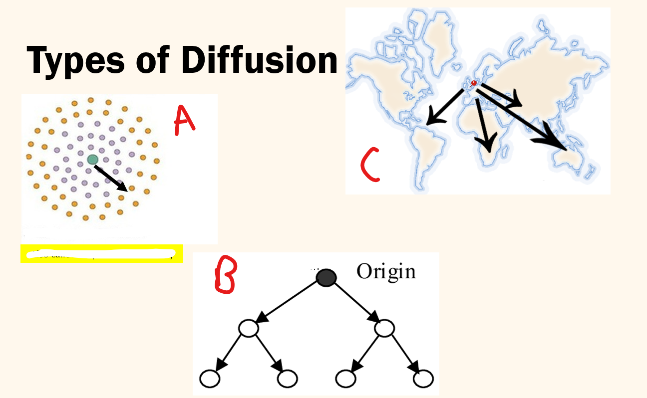
assign what types of diffusion each is
A: expansion/contagious diffusion
B: Hierarchical diffusion
C: Relocation diffusion
list what type of diffusion each one is:
technology
exercise trends
political movements
food/diet trends
disease
hierarchical: spreads from cities, influences, rich people first
contagious + hierarchical
relocation + contagious: people bring new ideas to places (relocation) and get people to join locally (contagious)
hierarchical + contagious: starts in cities with social media (hierarchical), then spreads by word of mouth (contagious)
all 3
covid-19 is what type of diffusion
all 3
relocation
someone from wuhan, china boarded a plane to italy= spread the virus there
hierarchical
spread through airports to major cities to hotels
contagious
spread from person to person through direct contact
eg. cough, close contacts
T/F Every person has a mental map
T
T/F Mentap maps of a specific region are the same for everyon
F
no two mental maps are alike
based on a person’s personal experience and memories
4 things that mental maps reveal
spatial awareness + lack of awareness
shows what places you know well + what places you ignore
priorities
you remember places that matter the most to you
eg. school, gym, home
psychology
shows your feelings or fears
you avoid an area that makes you feel unsafe
incorrect knowledge
mental maps can be wrong
you might think something is far when its actually close
how do mental maps dictate behaviour
it influences how you act (behaviour)
eg. you think a nearby place is far, so you avoid it
eg. you choose to visit places you remember fondly of and feel safe in & avoid areas that appear boring or unsafe
eg. how you travel - you take the route you believe is the fastest, even if it isn’t
what is spatial awareness
knowing where things are around you + how they relate to each other
how do mental maps help identify the following
service gaps
awareness gaps
invisible features
differences between individuals
personal attributes
lack of knowledge
service gaps
where people feel services like police or healthcare is missing
awareness gaps
people may not be aware of common services like stores
invisible features
identifies areas that aren’t marked on real maps
eg. gang zones or high-crime unsafe areas
differences between individuals
everyone sees places differently
locals vs. newcomers, men vs. women
personal attributes
someones age, gender, culture
lack of knowledge
people may not know where to go during an evacuation = dangerous
You must be ____ of a place before you can take advantage of it
aware
how are mental maps useful for planning out evacuation routes during tsunamis
talk about the issue and solution
It was discovered majority of citizens lived in dangerous hazard tsunami zones
Professionals spoke with survivors and what their escape plan was
They would map the responses in a mental map
Response
didn’t have a plan
used the same escape route
unsafe bc it can lead to overcrowding and road block
trying to run away rather than finding a tall building
Solution
Build new roads and ask citizens to use certain roads based on where they lived
Made it easier to evacuate an entire community within a couple minutes
add signs that point to locations of tall buildings
define hazard awareness + examples of it in the tsunami evacuation video
→ recognizing dangers before they cause damage
being alert to potential risks and knowing when to act, to avoid it
video
delayed evacuation: people not realizing how serious tsunami is
non-evacuation: not believing it’s that serious
people trying to outrun the wave by fleeing horizontally, rather than finding a tall building
Your spatial behaviour depends on your spatial ________
awareness
naturally, people choose the solution that make the most sense based on what they know about a place
Note: important to be spatially aware rather than rely on mental maps, especially during emergencies