IB Geography: Extreme Environments
1/126
There's no tags or description
Looks like no tags are added yet.
Name | Mastery | Learn | Test | Matching | Spaced | Call with Kai |
|---|
No study sessions yet.
127 Terms
What is a polar environment? And where?
- Year round permanent snow/ice.
-In the high latitudes above 65-70*N and some parts of the southern hemisphere
What is a glacial environment?
An area covered with snow and ice on a long term basis, where glacial process operate
What is periglacial/tundra? And where?
- Areas found on the edge of glaciers or ice masses.
-Intense freeze-thaw cycles
- High latitudes and altitudes. eg Himilayas, Andies and Rockies
-Cover ¼ of the earth
What is freeze thaw action?
The freezing and subsequent thawing of water
Other than areas with a high latitude. where can snow/ice be found?
In mountains in non-tropical latitudes, where the altitude is so high that there is year round ice and snow
How does Köppen-Geiger Climate Classification work?
Each country is coloured, depending on temperature, and given a letter based on its climate, precipitation and temperature
Where are most glaciers found?
In Greenland, on the coast of South America and North America and in high mountains
Polar characteristics (5)
- Year round permanent snow/ice
- Always below 0*C
- Precipitation below 200mm
- Extreme seasonality
- Flat relief
Periglacial/tundra characteristics (5)
- Seasonal ice cover
- High precipitation
- Tundra biome
- Sporadic/discontinuous permafrost
- Usually flat relief, up to 12 degree gradient
High mountains characteristics (5)
- Year round permanent snow/ice
- Cold all year due to altitude/snow line
- Extreme diurnal temp variation
- Limited biological activity
- High relief
What is a glacier?
A huge mass of ice + compacted snow slowly flowing over land mass
in an area where snow accumulation exceeds melting and sublimation
What is sublimation?
solid to gas
What is the snow line?
The point above which snow and ice forms on a mountain
Why is the snow line higher in hot countries?
Because you need to go higher up to reach temperatures cold enough for snow to form
What are glaciers made of?
Fallen snow that has compacted into large thickened ice masses
What is firn?
Snow that has survived one season
What is ice?
Interconnected air pockets become sealed off, isolating any air into separate air bubbles
How much of the earth surface is taken up by glaciers?
10%
Why is the amount of solar radiation received by the Earth not distributed evenly?
Because the Earth is titled at an axis of 23.5 so when the earth rotates the sun doesn't hit the earth evenly
What in insolation?
The solar radiation that reaches the earth's surface
What is albedo?
The reflectivity of a surface
Which is the most defective surface?
Dense, dry clean snow
What is the albedo of snow?
86-95
EG : low latitude but high altitude
Himalayas in Nepal - very close to equator but also very cold
What is environmental lapse rate?
The temperature decreases by 6.5°C for about every 1000m you go up
Why is air colder as you go up?
The pressure is lower, so is unable to hold as much heat
Why does the tricellular model occur?
There is an uneven distribution of insolation
if this isn't corrected then the tropics would become too hot and the polar regions would be too cold
so the planet redistributes this heat to find an equilibrium
How does the tricellular model work?
Warm air from the equator rises and cold air sinks, this forms a convection current, which triggers two other convection currents either side, distributing the heat from the equator to the polar regions
What happens when warm air rises?
Low pressure and rainfall
What happens when cold air sinks?
High pressure and lack of rainfall
Where is the Hadley cell?
Nearest the equator
Where is the Ferrel cell?
In the middle between latitudes 30-60°
Where is the polar cell?
Nearest the polar regions
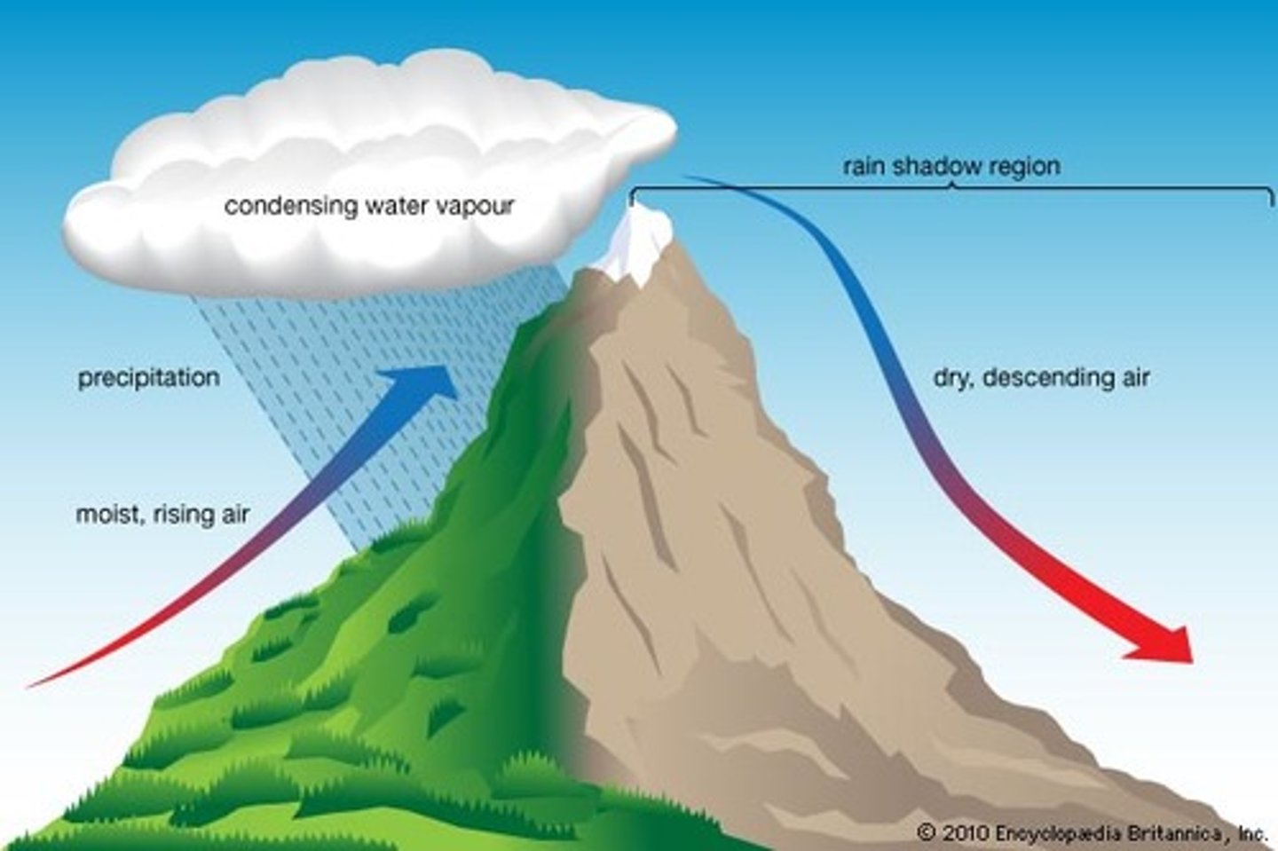
Four main factors that affect the location of a desert
1. Pressure conditions
2. Distance from the sea
3. Rain shadow effect
4. Proximity to cold upwelling currents
What is a fold mountain?
Mountain ranges that are formed at either a destructive or conservative plate boundary
How are fold mountains formed?
Through orogeny. When an area of sea separates two plates, sediment settles and compresses becoming sedimentary rock. The plates then move towards each other and the rock folds
What is a geosyncline?
A depression in the sea floor
What is permafrost?
Ground that remains frozen and stays at or below 0°C for two or more years
What is alpine or mountain permafrost? Example?
- Permafrost found in low latitude regions with a high elevation
- Andes
What affects the thickness of permafrost? (5)
- Snow cover
- Temperature of air near the ground
- Vegetation cover
- Bodies of water (higher soil water content)
- Heat from the interior of the Earth
What is the active layer of permafrost?
The uppermost ground layer which thaws in the summer and freezes in the winter
How is vegetation affected by the active layer of permafrost?
Plants can only grow within the active layer, as the roots are unable to break through the foreign ground beneath the layer
What is talik?
The layer of unfrozen ground below a lake
What are the types of permafrost?
- Continuous
- Discontinuous
- Extensive
- Sporadic
What is continuous permafrost? Location?
- Where permafrost is found underlying nearly all of the landscape, except under lakes that don't freeze all the way to the bottom
- In regions with severe winter and temperatures below freezing
What is discontinuous permafrost? Location?
- Permafrost that doesn't continuously cover an area - there are areas of unfrozen ground
-Regions with annual temperature slightly below 0°C
Location of extensive discontinuous permafrost ?
Mean annual temperature ranges between 2°C and -4°C
What is sporadic permafrost? Location?
- Permafrost that is found in isolated patches or islands
- Areas where the mean annual temperature ranges between 0°C and -2°C
Why are high mountains difficult for human habitation? (3)
- Risk of landslides and avalanches
- Too cold
- Only a thin layer of soil so difficult for farming
How do polar iceberg pose a threat to shipping lanes? Example?
- Icebergs break off and straying to areas where they aren't expected to be - can sink ships
- Large iceberg (80km long and 40km wide) broke off Larsen Ice Shelf in Antarctica
Challenges due to cold temperatures in periglacial climates (5) 🌱 💧 🏚 🚽
- Low temperature reduce plant growth
- Long hours of darkness can limit plant growth
- Ground tends to be waterlogged
- Building construction can cause the ice to melt causing subsidence
- Makes it difficult to provide services such as water and sewage disposal
What is subsidence?
When the ground sinks
How have people adapted to living near glaciers? (3)
- Drinking water
- Irrigation
- People generate HEP from melt water
Factors that affect population density (8)
- Climate
- Access
- Resources
- Facilities
- Remoteness
- Altitude
- Hazardous conditions
- Communication
Types of periglacial regions
Arctic continental, Alpine and Arctic maritime
What is pattered ground? Location?
- When rocks and pebbles line up on the ground to form a pattern
- S Iceland
How does patterned ground form?
Underneath pebbles in the ground is an ice lens, and in the night when temperatures drop, this ice lens freezes and expands, pushing the pebble up. Eventually these pebbles reach the ground surface and roll down slopes, forming a pattern
What are pingos? Size?
- Ice cored mounds that rise above a flat plain that consists of silt and sand
- Up to 60-70m
Where are open system pingos formed? Eg?
- In valley bottoms
- E Greenland
Where are closed system pingos found? Eg?
- Beneath lake beds
- Mackenzie delta, Canada
What happens when a pingo collapses?
An incision is left behind and filled as a pond
How do open system pingos form?
Water collected in a valley bottom with an area of talik, and water seeps into the talik. When temperatures drop, the talik expands and pushes the surface into a dome forming a pingo
How do closed system pingos form?
Under a lake there will be talik, and when the lake drains this talik is exposed to the cold and thus shrinks. The water becomes concentration within the talik and freezes to form a lump of ice which forms a pingo
What is thermokarst?
Irregular surfaces of marshy hollows and small hummocks formed by freezing and thawing, and subsequent subsidence
What is plucking? Where does it occur?
- When meltwater from a glacier freezes around a lump of rock, and when the ice moves downhill the rock is ripped from the back wall
- Base and sides of glacier
What is abrasion?
When rock frozen to the base and back of a glacier scratches the bed rocks leaving striations
What is basal debris?
Debris at the base of the glacier
What affects the rate of erosions processes? (4)
- Presence of basal debris
- Underlying geology
- Ice thickness
- Debris size and shape
Where are cirques found?
- North or east facing slopes of mountains
- Accumulation is greater than ablation
How are cirques formed?
1. A periglacial hollow is enlarged by freeze thaw and removal by snow melt
2. Ice accumulates in this hollow
3. Having reached a critical weight, the ice moves out in a rotational manner, eroding the floor by plucking and abrasion
4. Meltwater trickling down allows the cirque to grow by freeze thaw
Bergschrund
A crevasse at the head of a glacier
Crevasse
A deep crack or fissure in the ice of a glacier
Arête
A jagged, narrow ridge that separates two adjacent glacier valleys or cirques
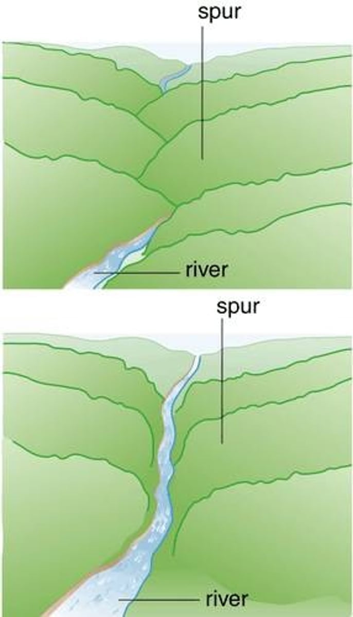
Truncated spurs
Eroded triangular shaped cliffs in glaciated valleys
Ribbon lakes
Long thin lake that fills the floor of a glaciated valley
Hanging valley
u-shaped valley left by a melted tributary glacier that enters a larger glacial valley above its base, high up on the valley wall
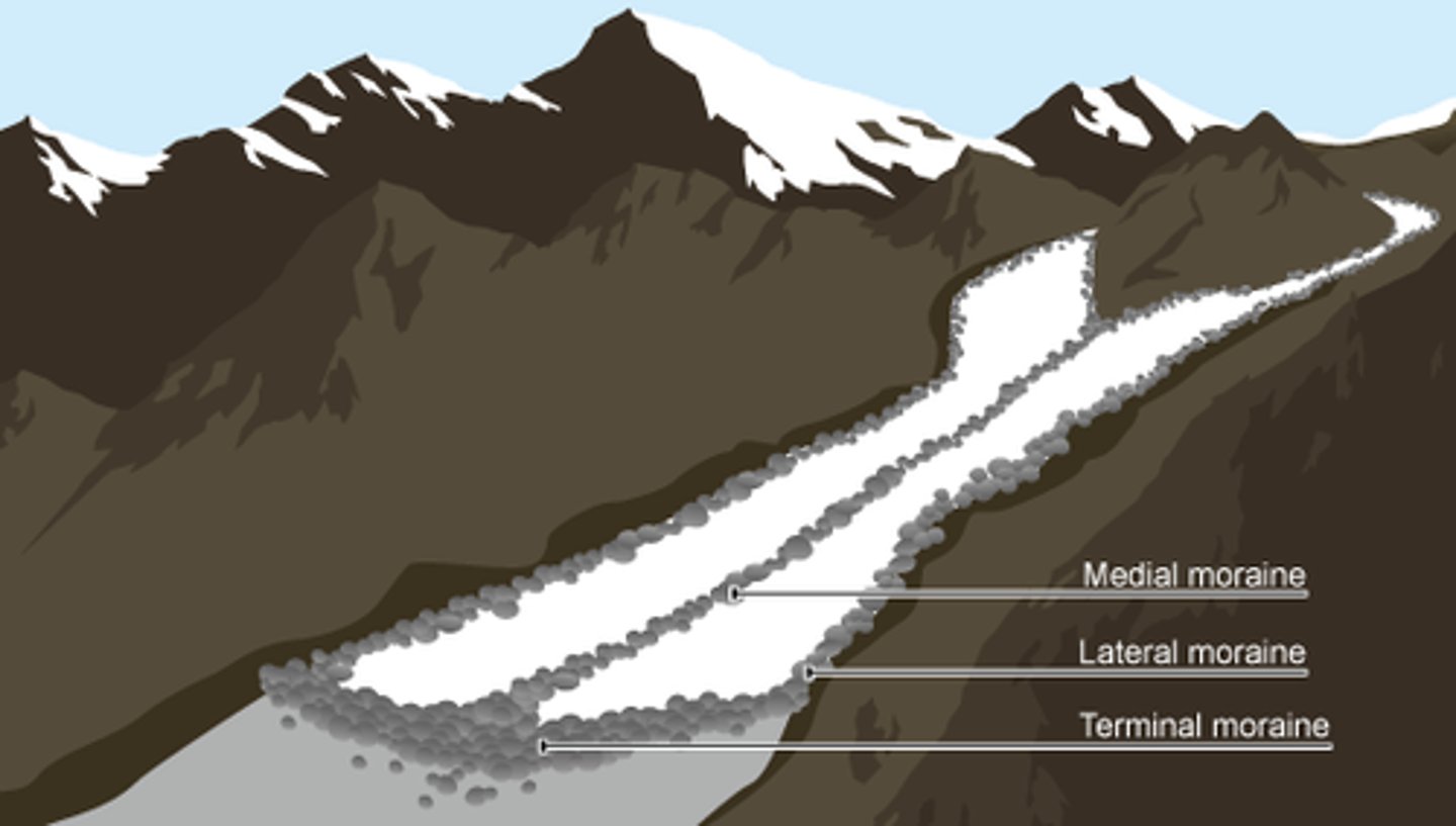
Lateral moraine
Moraine along the side of a glacier
What is meant by drift?
All the glacial and fluvioglacial deposits left after the ice has melted
Characteristics of glacial deposits
- Angular
- Unsorted
- Mixed sizes and rock type
- Striations
Erratics
Boulders transported by a glacier with foreign geology

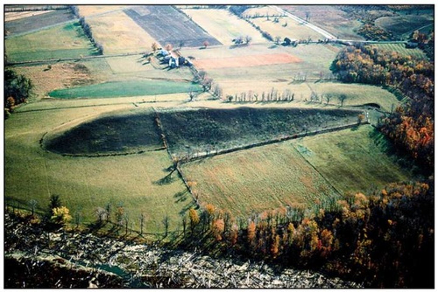
Drumlin
A long mound of till that is smoothed in the direction of the glacier's flow
Medial moraine
- A moraine formed when two valley glaciers come together to form a single ice stream
- Forms in the middle of the glacier
Up valley of a moraine
Side of the moraine in contact with the ice, usually the steeper side
Frost heave
When water freezes and it pushes particles in the soil upwards
Solifluction
The slow, downslope flow of soil saturated with water in areas surrounding glaciers at high elevations
Thermokarst
Depressions caused by the melting of permafrost
How can human activity lead to thermokarst?
Fires, removal of vegetation
Rain shadow effect
A side of the mountain that is kept dry and shielded by the mountain
Physical factors increasing the chance of a flash flood in hot environments? (3)
- High intensity rainfall
- Impermeable land
- Lack of vegetation
Human factors that cause desertification (5)
- Overgrazing
- Mismanagement of water supplies
- Deforestation
- Over population
- Global warming
Reasons why people are in hot arid areas
- Tourism
- Jobs
- Resource abundance (Mining/mineral deposits e.g. uranium mining in Niger)/Aquifers
- Family + friends
- Military
- People enjoy the hot environment
Wadis
Dry gullies that have been eroded by flashfloods
Alluvial fan
Cones of sediment deposited by rivers when they move from the mountains to an open plain
Yardangs
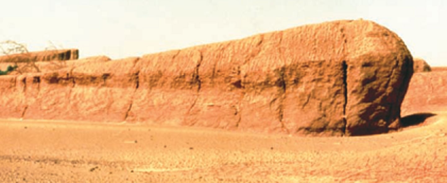
Wind eroded rocks, where alternating vertical strata of hard and soft rocks produce a series of ridges
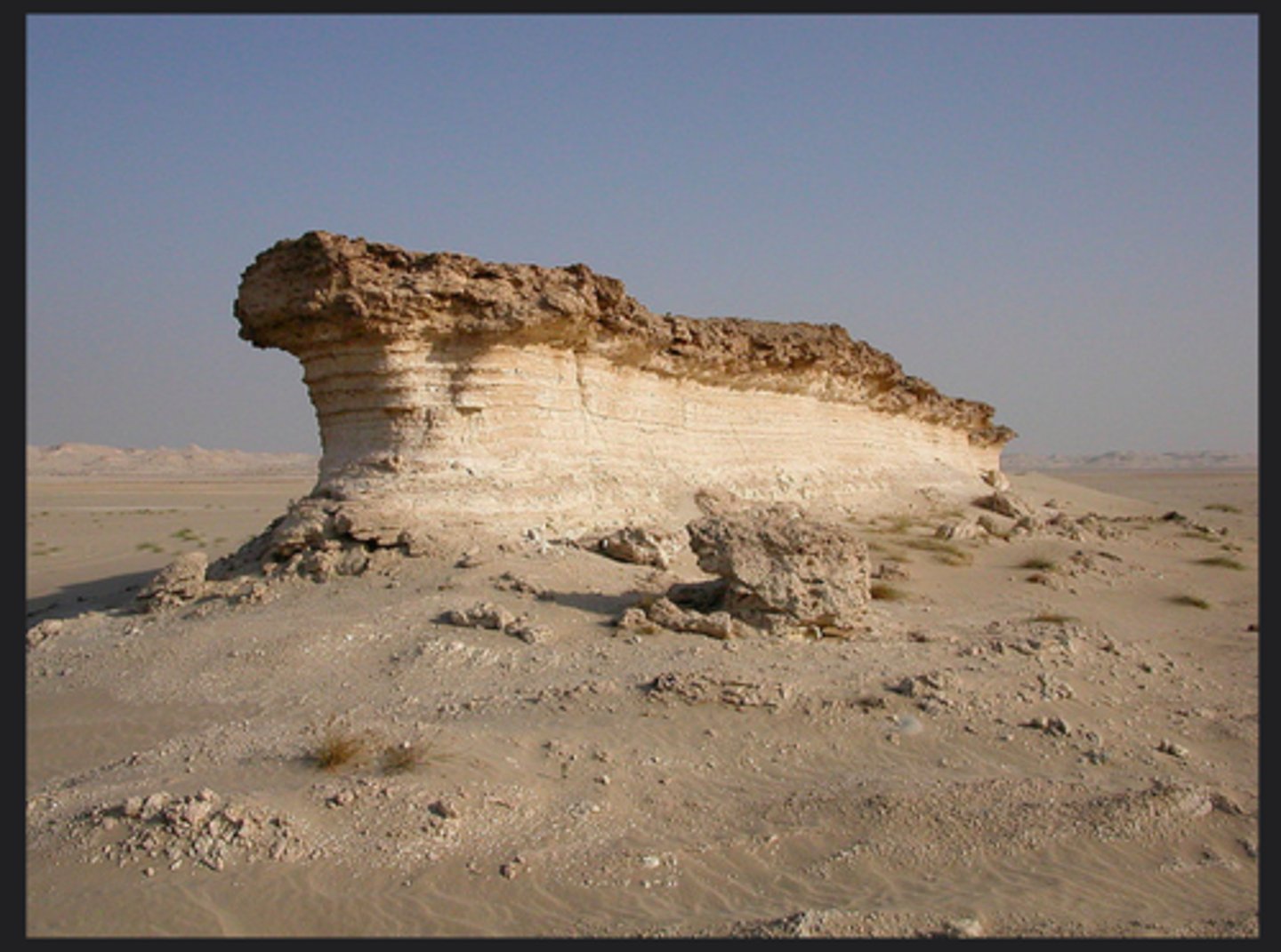
Zeugens
Wind eroded rock structures consisting of horizontal layers of hard and soft rock
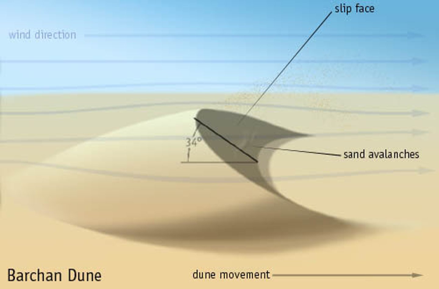
Barchan Dunes
Solitary crescent-shaped mounds of sand with downwind pointing tips. Occur when there is a limited sand supply, little vegetation and constant wind direction
Types of weathering in the desert
Salt crystallisation and disintegration
Salt crystallisation
Breakdown of rock by solutions of salt:
in temps around 26-28C sodium sulphate and sodium carbonate expand by 300%, and when the water evaporates this salt leaves pressure on the rock
Disintegration
Similar to freeze thaw
Exotic river
Comes from a different climate zone