Geography A level - Water and Carbon cycles
1/99
There's no tags or description
Looks like no tags are added yet.
Name | Mastery | Learn | Test | Matching | Spaced | Call with Kai |
|---|
No analytics yet
Send a link to your students to track their progress
100 Terms
System
a set of interrelated components that are connected together to form a working unit or unified whole
Dynamic equilibrium
the balanced state of a system when opposing forces, or inputs and outputs are equal
Inputs
elements that enter a system to be processed
Outputs
outcomes of processing within the system
Stores
amounts of energy or matter held, and not transferred until the appropriate processes are in place to move them
Transfers or flows
movements of energy or matter through the system, which enable inputs to become outputs
Positive feedback
where a change causes a further effect, continuing or even accelerating the original change
Negative feedback
acts to lessen the effect of the original change and ultimately reverse it
Key features of major water stores
- 97% worlds water is saline sea water
- 79% total fresh water is locked in ice and glaciers
- 20% fresh water is I'm in the ground
- 1% is surface fresh water
Major water stores
- hydrosphere
- atmosphere
- cryosphere
- lithosphere
Hydrosphere
- supply 90% of evaporated water to water cycle
- hold majority of all water on earth
Atmosphere
- contains 0.001% of earths total water
- main vector that moves water around the globe
- clouds are visible manifestation of atmospheric water
Cryosphere
- Antarctica holds 90% of Earth's ice mass
- Greenland ice cap contains 10% of total global ice mass
- ice caps and glaciers cover about 10% of the Earth's surface
- ice shelves cover 11% of total area in Antarctica
- sea ice surrounds polar regions
Lithosphere
- surface fresh water represents 2.5% of all water on Earth
- rivers hold only 0.006% of total fresh water reserves
- lots of water held in aquifers
Ice shelf
a floating extension of land ice
Aquifer
a permeable rock that can store and transmit water
Evaporation
the process by which water changes from a liquid to a gas or vapour
- head energy necessary to occur to break the bonds that hold water molecules together
Condensation
the process by which water vapour in the air is changed into liquid water
- occurs when saturated air is cooled to below the dew point
Precipitation
water released from clouds in the form of rain, freezing rain, sleet, snow or hail
Dew point
the temperature at which a body of air at a given atmospheric pressure becomes fully saturated when cooled
Evapotranspiration
the combined water gain by the atmosphere through evaporation and transpiration
Precipitation mechanism
- tiny water droplets condense on microscopic particles which act as condensation nuclei
- droplets grow to additional condensation of water vapour or when the droplets collide
- condensation and collisions occur to produce a droplet with a fall velocity that exceeds the cloud updraft speed
- the droplet then falls out of the cloud as precipitation
Drainage basin
the catchment area from which a river system obtains its supply of water
Watershed
the imaginary line that separates adjacent drainage basins
Runoff
the amount of water that leaves a drainage basin through a river
Groundwater store
water that collects underground in pore spaces in rock
Groundwater flow
the movement of groundwater. the sis the slowest transfer and provides water to rivers during drought
Infiltration
the movement of water from the surface downwards into the soil
Interception
the process by which precipitation in prevented from reaching the soil by the leaves and branches of trees as well as by plants and grasses
Overland flow
the movement of water over saturated or impermeable land
Percolation
the downward movement of water from soil into the rock below or within
Stemflow
the water that runs down the stems and trunks of plants and trees to the ground
Throughfall
the water that drips off leaves during a rainstorm
Throughflow
the water that moves down-slope through soil
Flood hydro-graph
- graph of discharge or a river before, during and following a storm event
- can help predict how a river might respond to a rainstorm, which in turn can help in managing a river
- is described as flashy when water is transferred to a river quickly - responds rapidly to storm and leads to flooding
Natural variables that affect flood hydro-graph
- antecedent rainfall = rain falling on saturated ground produces steep rising limb and short lag time
- snowmelt = release of lots of water greatly and rapidly increase discharge
- vegetation = in summer interception higher, discharge lower and greater lag time
- basin shape = water takes less time to reach river in circular drainage basin
- slope = steep-sided drainage basins mean water gets to river quicker
- geology = permeable rocks allow percolation which slows water transfer, impermeable rock give greater discharge and short lag
Natural variations in water cycle
- storm events = cause steep rising limb, short lag time and steep recession limb
- cyclonic rainfall = can cause multiple flood events, timeline in hours / days, similar period for recovery
- seasonal floods = seasonal rainfall such as monsoon, seasonal snowmelt
Human impacts in water cycle
- farming practices - changing of vegetation cover changes interception rate
- land use change - more impermeable surfaces
- water abstraction - use water from natural stores e.g. aquifers - water table lowered
Stores of carbon
- most of earths carbon is stored in lithosphere (100m PgC)
- much of this in fossil fuel rock and limestone
- remainder in hydrosphere (38000 PgC), atmosphere (750 PgC), biosphere (3000 PgC) and cryosphere (unknown)
- carbon flows between each of these stores
- any shift in in one store will directly effect another
Changes in the magnitude of stores
- weak carbonic acid falls as acid rain
- acid dissolves rocks and releases ions
- plants break up surface granites in growth
- micro-organisms hasten this weathering with enzymes and acidic soils
Carbon sequestration in oceans and sediments
- weathers calcium and bicarbonates are washed to sea and used by microscopic marine animals to form shells
- ocean algae also draw down co2 from air
- when microfauna die their shells sink ocean floor and are compressed to form sediment
- carbon locked up in limestone can be stored for millions of years
- carbon also stored in rocks by plant material that built up too quickly to decay - to come coal oil and gas
- carbon also stored in compressed clay deposits called shales
Photosynthesis, respiration, decomposition and combustion - carbon cycle
- during photosynthesis plants absorb co2 and sunlight to create glucose for building plant structures
- phytoplankton also take co2 from atmosphere by absorbing it into cells
- both create carbohydrate and o2
- carbon then returned to atmosphere by respiration, decomposition and combustion
Natural variations in carbon cycle
- wild fires
- volcanic activity
Human impacts of the carbon cycle
- hydrocarbon fuel extraction and burning
- farming practices
Impacts on carbon stores from deforestation
- biomass from trees may be burned, releasing carbon into the atmosphere
- forrest clearance accelerates decay of dead wood and litter as well as below ground organic stores
- tropical regions biomass will decay in less than 10 years
- some carbon accretes to soil carbon pool
- less photosynthesis and respiration from trees
- but increased respiration by decomposers
Land-use effects on carbon
- deforestation (-ve)
- drainage of wetlands (-ve)
- afforestation (+ve)
- all contribute to net 1.6PgC to atmosphere
IPCC
Intergovernmental Panel on Climate Change
Carbon budget
the balance of exchanges between the four major stores of carbon
Increasing carbon budget facts
- 2003-2013 increase in atmospheric co2 correlated to 45% co2 emitted by human activity
- 2013 atmospheric co2 reached 142% of pre-industrial level
- current carbon budget shows net gain of 4.4PgC per year in the atmosphere
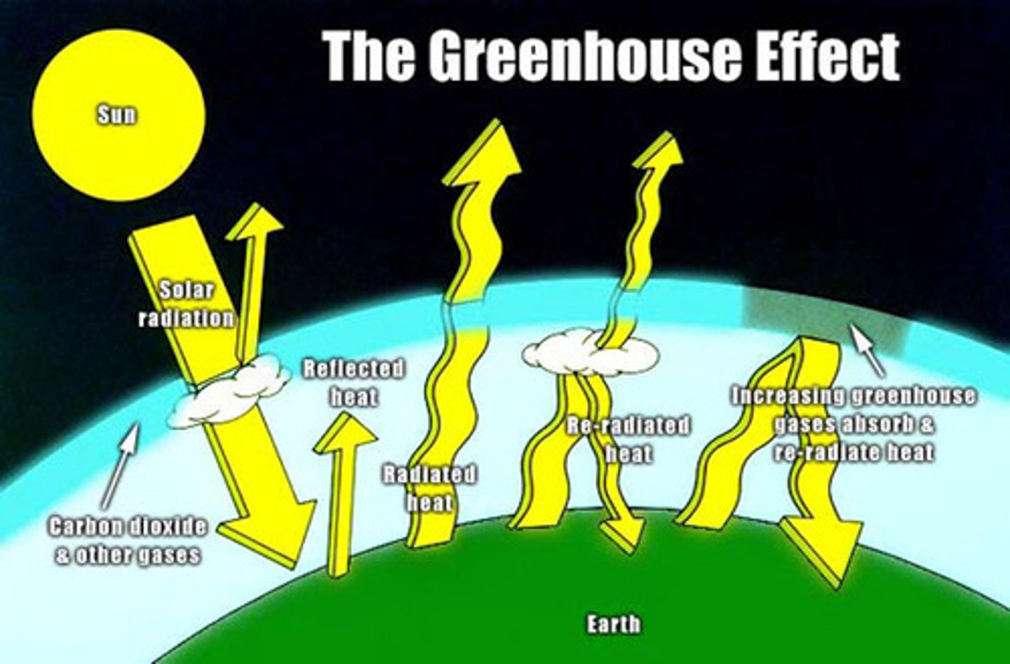
Greenhouse effect
the natural process whereby outgoing thermal radiation is trapped by atmospheric gases such as water vapour and co2
Enhanced greenhouse effect
the increased impact of greater amounts of GHGs caused by human activity
Relationship between water and carbon cycle and climate change...
- change in the carbon cycle are the causes of climate change, through the combination of the greenhouse and enhanced greenhouse effects
- climate change will the have a further effect on the water and carbon cycles respectively
- humans have to either adapt to hazards of climate change or mitigate, or both
The greenhouse effect diagram
1. Sunlight passes through atmosphere.
2. energy is re-absorbed or re-radiated as long wave radiation
3. Heat is captured by greenhouse gases and kept in atmosphere leading to a warmer temperature.
Positive feedbacks in climate change
- as oceans warm, more water is evaporated, which amplifies natural greenhouse warming
- warm ocean water is less able to absorb co2, so more in atmosphere
- warm temperatures warm permafrost, releasing co2 in tundra and peat bogs
Human mitigation
- setting targets to reduce GHGs
- switching to renewable energy sources
- capturing carbon emission and sequestering them
Human adaptation
- developing drought- resistant crops
- managing coastline retreat in areas vulnerable to sea level rise
- investigating in fresh water provision to cope with higher levels of drought
The Kyoto Protocol
- set legally binding targets for co2 emissions compared with 1990
- proposed schemes to enable governments to reach targets
Evaluation of Kyoto Protocol
Success:
- UK's climate change act 2008
- EU emissions 22% lower than 1990
- 75 countries developed less polluting technology
- started global approach to dealing with anthropogenic climate change
Failures:
- slow ratification (Canada withdrew and USA did not ratify)
- growth of emissions by 65% globally due to China and India
- carbon sinks and carbon trading systems between countries set up
- only industrial countries involved, not BRIC
COP21 Paris Agreement 2015
- temperatures should not increase by more than 1.5'C by 2100
- GHG emissions allowed to rise for now, but more sequestration planned to keep within limits
- emissions targets set by individual countries and reviewed every 5 years
Effects of water cycle and climate change on the Amazon rainforest
- increase temp will increase evapotranspiration
- El Nino may occur more frequently as sea temperatures warm
- decrease of precipitation on dry season
- more intense rainfall in wet season
- increased erosion and flooding will destroy low lysing areas
- glaciers will shrink
Effects of the carbon cycle and climate change on the Amazon rainforest
- 40% plant species may become unviable by 2050
- reduction in net carbon store as a result
- wild fires will increase as dry seasons lengthen
- will become a net source of co2 rather than a sink
Fixed amount of water in the earth-atmosphere system
1,385 million cubic kilometres in volume
- at any moment is held in one of several stores of is being transferred between via a series of flows
Store
a reservoir where water is held, such as the ocean or ice caps
Flow
is movement / transfer / flux between stores in a system
Cyrosphere
those areas of the earth where water is frozen into snow or ice, including ice caps, sheets, alpine glaciers, sea ice and permafrost
Global stores
atmosphere, ocean, soil, rivers, lakes, reservoirs and vegetation
Water flows
- water flow entering a store in an input
- flows leaving stores are outputs
- global hydrological cycle is a closed system
- does not have any external inputs or outputs operating across the system boundary
- systems mass balance doesn't change over time
Mass balance
means that the total amount of water is always conserved, although changes can occur in where it is stored or accumulates. at a local scale (drainage basin), water systems imputes are equal to outputs, plus or minus any changes in storage
The global water cycle
1. in the oceans the vast majority of water is stored in liquid form, with only a minute fraction as icebergs
2. in the cry-sphere water is largely found in a solid state, with some in liquid form as meltwater and lakes
3. on land the water is stored in rivers, streams, lakes and groundwater in liquid form. it is often known as blue water, the visible part of the hydrological cycle. water can also be stored in vegetation after interception or beneath the surface in the soil. w ayer stored in the soil and vegetation is often known as green water, the invisible part of the hydrological cycle
4. water largely exists as vapour in the atmosphere, with the carrying capacity directly linked to temperature. Clouds can contain minute droplets of liquid water or, at a high altitude, ice crystals, both of which are a precursor to rain.
Cryospheric water
1. sea ice (the ross ice shelf)
2. ice caps (the Iceland ice cap)
3. ice sheets (the Greenland ice sheet)
4. alpine glaciers (mar der glace, france)
5. permafrost (the Alaska north slope)
Seasonal changes in cryosphere storage
- seasonal variations in ice accumulation (build up) and ablation (change from solid ice to liquid or vapour above 1'C) bring marked fluctuations in water flows and storage in mountainous glaciated regions
- balance is called the steady state equilibrium - the system maintains balance when viewed over long term despite imbalances within times of the year
- extent of arctic sea ice reduced by 50% during summer
- also permanent reduction is size due to anthropogenic reasons
Long term changes in cryosphere storage
- glacial and inter glacial epochs
- cryogenian ice ages 650-750 million years ago
- paleocene and eocene epochs 65-35 million years ago - the poles were ice free so global sea levels higher due to 99% off water in oceans
- changes due to milankovitch cycles and plate tectonic movements
Seasonal changes in rainfall
- monsoon especially wet season triggered by periodic alternation of wind direction and velocity, affecting some tropical regions of the world (east Asia)
- strongest felt in India, Pakistan, china
- in SW india more than 2/3 of the years rainfall falls in 3 months each year so transfers from atmosphere to land and land to sea are seasonally uneven
Year to year climatic and rainfall variability
- el nino southern oscillation is natural climatic phenomena in Pacific basin which recurs every 3-5 years and last for 18 months
- cool water normally found along the coast of Peru is replaced by warmer water, and warmer water near Australia and indonesia becomes colder
- very dry conditions arrive in Asia
- precipitation transfers from atmosphere to land are greatly reduced for a period of time, but increases along east-central and eastern pacific ocean (California)
Long term changes in rainfall and aridity
- anthropogenic climate change
- warmer air can hold more moisture, so precipitation will change
- areas with rain will experience more
- but arid areas will experience less
- increase in episodic and heavy downfalls, punctuated by longer periods of drought
- increased aridity in Sahel, china, USA and Australia
- rainfall change in UK - longer and hotter summers and warmer and wetter winters
- also lose ice sheets - Antarctica is currently losing more ice than it gains - 70 gigatonnes loss a year
- if all melts sea levels could rise by 70 metres
Drainage basin
- subset of the hydrological cycle, and is the catchment area forming part of the wraths surface which is drained by a particular stream of river
- all land belongs in a drainage basin
- dividing line between basins is the watershed
- drainage basins are open systems
Drainage basin inputs
- precipitation (rain, snow, sleet, hail, frost)
- duration and intensity affect how drainage basin systems respond
- in Uk rainfall between 50 and 100 mm per hour causes flash flooding (boscastle 2004 as a result of 185mm rainfall in five hours)
- low intensity but long duration rainfall is much more common
Drainage basin flows
- through fall: rainwater dripping from leaves and branches towards ground
- stemflow: water falls directly onto vegetation but flows to ground via stems and trunks
- infiltration: movement of water from the ground surface into the soil
- infiltration capacity: the rate at which water can pass into soil
- through flow: movement of water laterally through the soil, via pores, fissures and pipes in soil created by roots and burrows
- percolation: transfer of water from soil into underlying bedrock
- groundwater flow: vertical and lateral movement of water through drainage basins underlying rock as a result of gravity ad pressure
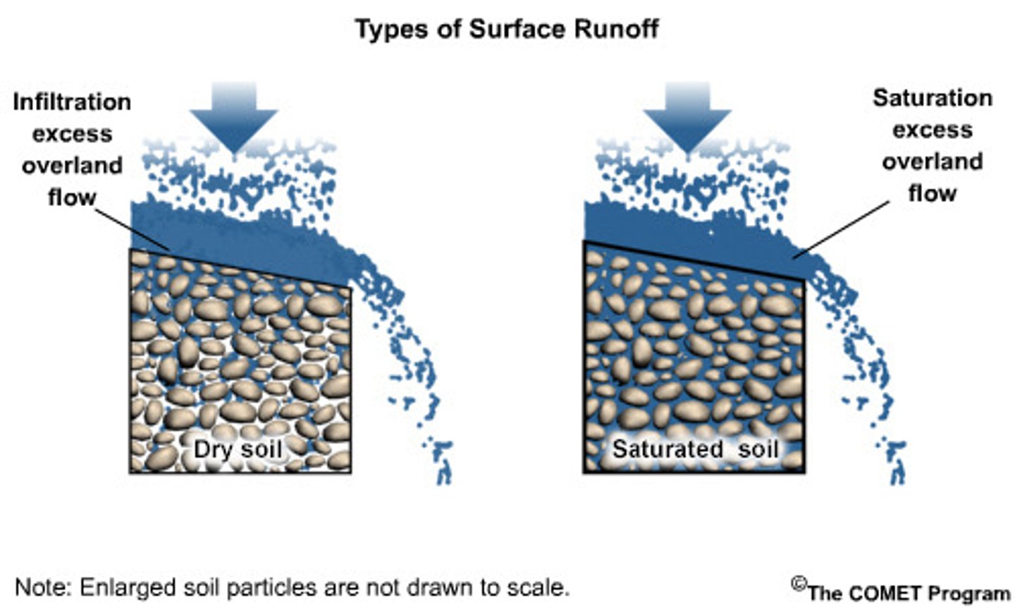
Saturation-excess overland flow
- if rainfall continues for a long time
- all soil layers become saturated and through flow is deflected closer and closer to surface as upper and more permeable soil become saturated as water level in soil rises
- then overland flow occurs

Infiltration-excess overland flow
- overland flow which occurs when rainfall intensity is so great that not all water can infiltrate, irrespective of how dry or wet the soil was before rainfall event
- common in semi arid areas
- leads to flash flooding
Drainage basin stores
- interception stores (leaf and plant surfaces)
- vegetation store (water held in the biomass itself - green water)
- surface store (water collected on surface of ground)
- soil moisture store (water held in pore spaces in soil matrix)
- channel store (water held in the river channel itself at any moment in time)
- groundwater store (water stored in solid rocks and in any superficial deposits)
Capacity for interception storage of different global biomes
- tropical rainforest tress are well adapted to a hot humid equatorial climate by possessing 'drip tip' leaves: these encourage a more rapid flow of rainwater through the tree canopy and towards the ground via throughfall and stem flow
- high latitude coniferous trees have sloping branches: snow slides towards the ground instead of building up on the branches, which might cause them to break. as a result of this adaptation, snow is transmitted from th vegetation store to the drainage basin's surface store.
Pluvial flooding
the collection of large amounts of surfacer water can result in flooding in urban areas especially
Three different types of soil water
1. hydroscopic water: water adhering in thin films by molecular attraction to the surface of soil particles
2. capillary water: water forming thicker films and occupying the smaller pore spaces in the soil, held against force of gravity by surface tension, important for plant health and remains in soil
3. gravitational water: excess water that occupies all large and usually free-draining spaces in soil, this transitory water drains away soon after rain stops falling
Drainage basin outputs
1. evaporation: change in state from liquid to gas, where heat energy is required. can occur from water surface. dependant on temperature, humidity and wind speed
2. transpiration: the diffusion of water from vegetation into the atmosphere involving a cane from liquid to gas, water lost through stomata. Evapotranspiration.
3. Channel discharge: the volume of water leaving a drainage basin via its main stream or river during a specific unit of time
River regime
the annual variations in the pattern of flow, or discharge, of a river, measured at a particular point
- flow from base flow and storm flow
River regime influenced by...
- annual pattern of precipitation, snowmelt, temperatures and evaporation, along with the factors of relief, vegetation and the underlying soil and geology
- human factors include construction of damns and reservoirs, levels of irrigation and the extent to which water is removed from a river through transfer schemes that help supply other places with water
Storm hydro-graph
- peak discharge: the maximum rate of flow during a storm event
- peak rainfall: the maximum rainfall recorded in one of the time intervals
- rising limb: the part of a storm hydrograph in which the discharge starts to rise
- lag time: the time elapsed between peak rainfall and peak discharge
- falling limb: the part of the storm hydrophraph in which the discharge starts to fall
- preceding discharge: the rate of flow prior to the latest storm event
- bankfull discharge: the maximum discharge reached during a storm event prior to overtopping of the river banks and the inundation of the floodplain with excess water
- baseflow: the normal minimum flow of the river (supplied by groundwater flow)

Climatic influences on storm hydrographs
- antecedent conditions: the weather and soil moisture conditions immediately prior to a storm event are called
- if the basins soil was already saturated then overland flow have occurred early on in storm event, creating a flashy graph
- in low intensity rainfall on dry ground is unlikely to produce a flashy graph
- flashiest associated with high intensity winter rainfall at a time of year when evaporation and transpiration outputs are minimal
- snow melt creates greatly delayed peak discharge
Non-climatic influences on storm hydrographs
- steep relief and impermeable geology creates flashes
- free draining and sandy soils or highly permeable porous geology can lower an areas overland flow and flood risk
- flashy hydrographs more likely to be seen in poorly drained upland regions of the UK where grass or peat moorland dominates, resulting in limited interception storage
- soils and land use: pasture has good infiltration but urban areas create peaks in hydrographs
- size and shape of drainage basin along with its drainage density (measure of the length of the river channel and its tributaries per unit area)
Precipitation
- condensation must take place, by cooling of air below its dew point or by continued evaporation resulting in saturation of the air
- condensation leads to cloud formation and possible precipitation
- water droplets in the atmosphere form typically when condensation takes place around small dust or sea salt particles - condensation nuclei
Air uplift and condensation
- the reason why air uplift leads to cooling and condensation is because of the fall in pressure with altitude
- this results in the expansion of air
- as a result, there are fewer collisions between air molecules. this reduces the amount of heat energy per unit volume and leads to a fall in air temperature
- cloud formation take place once air temperatures have fallen low enough for water vapour to condense into water droplets
Reasons for air uplift
1. convectional rain: results from intense daytime heating of the land. air parcels adjacent to the ground heat up by conduction; they rise, cool and may form cumulus or cumulonimbus cloud
2. frontal rain: forms when two surface air streams meet, for instance when polar and tropical air masses meet over the north Atlantic Ocean in the mid-latitudes, the latter will rise up over the former under low pressure conditions
3. orographic rainfall: the result of uplift related to relief features, augmented by feeder-seeder mechanism - creates rain shadow effect
Feeder-seeder mechanism
a process that increases levels of orographic rainfall. water droplets or ice particles from high altitude 'seeder' clouds fall through a lower-level orographic stratus cloud (the feeder), collecting more cloud water as they do so, which results I heavier rainfall
The Bergeron-findeisen process (precipitation)
- clouds at high altitude with temperatures just below 0'C contain a mixture of water droplets and ice crystals
- the ice crystals grow quickly at the expense of the water droplets (because of a rapid flux of water vapour from the droplets towards the ice crystals)
- the ice crystals fracture as they are jostled by fast high-altitude air currents. hexagonal ice shapes begin to develop with an even larger surface area. now even more vapour can condense around these larger snowflake shapes, accelerating their rate of growth even further
- eventually, the hexagonal snowflakes become too large and dense to be held aloft. in falling to the ground, they pass through warmer air and melt to produce rain
The collision process (precipitation)
- super-sized condensation nuclei, such as are sea salt particles provide seeds around which water droplets form. these are far larger and heavier than normal sized droplets
- the larger super droplets fall and collide with smaller droplets by sweeping them into their wake and absorbing them
Causes of excess runoff generation
- snowmelt and ice ablation
- storm activity
- monsoons
urbanisation and overland flow generation
- urbanisation renders previously permeable ground surface impermeable
- surfaces such as concrete and tarmac increase surface runoff generation and decrease the effectiveness of infiltration, through flow and soil storage
- the more ground that is covered by impermeable hard surfaces such as concrete or paving slabs, the less rainfall will soak into the ground and the more will run over the surface into drains and sewers
- the drain and sewer network is effectively an extension of the river channel network which allows water to be drained from the land even faster
- there will be less transpiration and interception without vegetation, which means yet more runoff can be expected
Deforestation and overland flow generation
- 1919 forrest cover reached a low of 3%
- currently stands at 10%
- flood risk higher due to changing land use over time
- infiltration rate 67 times higher under tress than under sheep pasture
- Amazonia, 20% forest destroyed due to cattle ranching, soya bean production and larger scale agribusiness
Water balance
balance between precipitation, evapotranspiration and runoff